



The drainage system is an integrated system of tributaries and a mainstream that collects and funnel surface water to the sea, lake or some other water bodies. The total area that contributes water to a single drainage system is known as a drainage basin
Contents
- 1 Introduction to Drainage
- 2 Drainage Pattern of Rivers
- 3 Drainage system
- 3.1 Sequent Drainage System
- 3.2 Insequent Drainage System
- 3.3 Drainage System of Indian Rivers:
- 3.4 Government Initiatives for Ganga Conservation
- 3.5 The Indus River System
- 3.6 The Brahmaputra River System
- 3.7 The Brahmaputra System (Brahmaputra and its Tributaries)
- 3.8 The Peninsular Drainage System
- 3.9 List of Major Rivers of India
- 3.10 Major Towns Situated on the Banks of Rivers
- 4 Inland Drainage
- 5 River Regimes
- 6 Inter-State River Water Disputes
- 7 National Water Grid
- 8 National River Linking Project Plan
- 9 Lakes
- 10 Waterfalls
- 11 Prelims Facts
- 12 UPSC NCERT Practice Questions
- 12.1 1. When the rivers discharge their water from all directions in a lake or depression, the pattern is known as
- 12.2 2. The rivers of South India mainly have which of the following drainage patterns? UPPSC (Pre) 2014
- 12.3 3. Among the following tributaries, which one is the part of the Ganga river basin? BPSC (Pre) 2019
- 12.4 4. Which river flows through the valley of Kashmir? WBCS (Pre) 2013
- 12.5 5. Which of the following is not a tributary of Brahmaputra river? Manipur PSC (Pre) 2016
- 12.6 6. Identify the only tributary of river Ganges which rises in the plains.
- 12.7 7. Consider the following tributaries of river Yamuna and arrange them from West to East.
- 12.8 8. Four rivers have been mentioned below. What will be the decreasing order of these rivers in length (starting from the longest to the shortest)? HPSC (Pre) 2022
- 12.9 9. Dubbed as the Dakshin Ganga (the Ganges of the South), the largest river of South India is WBCS (Pre) 2021
- 12.10 10. Consider the following rivers. IAS (Pre) 2015
- 12.11 11. Consider the following rivers. IAS (Pre) 2015
- 12.12 12. Which of the following characteristic feature is appropriate for Narmada River? JPSC (Pre) 2021
- 12.13 13. The following characteristics are of which river?
- 12.14 14. The source of the Kaveri river lies in UPPSC (Mains) 2011
- 12.15 15. Kolleru Lake is located between WBCS (Pre) 2019,2021
- 12.16 16. Which of the following statements is correct? UPPSC (Pre) 2023
- 12.17 17. Chilika Lake is a WBCS (Pre) 2018
- 12.18 18. Hundru fall is formed on BPSC (Pre) 1994
- 12.19 19. Consider the following statements TAS (Pre) 2023
- 13 Know Right Answer
- 14 Frequently Asked Questions (FAQs)
- 14.1 Q: What is the significance of studying the drainage system of India for UPSC exams?
- 14.2 Q: Which are the major river systems discussed in UPSC NCERT Geography notes?
- 14.3 Q: How does the drainage system of India impact its agriculture and economy?
- 14.4 Q: What are the key challenges and issues related to India’s drainage system?
- 14.5 Q: How can the study of the drainage system contribute to disaster management in India?
- 15 In case you still have your doubts, contact us on 9811333901.
Introduction to Drainage
- The movement of water along well-defined channels is referred to as drainage, with these channels carving out distinct paths in various directions. Drainage is influenced by factors such as the nature and structure of rocks, geology, slope, topography, velocity, etc.
- A watershed denotes a smaller land area that directs water flow towards a particular stream, lake, or wetland.
- A river basin encompasses multiple watersheds, and these watersheds serve as boundaries that separate one drainage basin from another.
- The catchment area is where water accumulates before being directed by the river.
Drainage Pattern of Rivers
- Drainage basins represent regions where a large river, along with its tributaries, collects and discharges all its water.
- The arrangement formed by the river and its tributaries from the origin of the river to its mouth is termed a drainage pattern.
Drainage Pattern of Rivers
| Name | Description |
| Dendritic Drainage | A drainage pattern resembling tree branches with lots of twigs. Examples include rivers in the Northern plain like Ganga, Yamuna, etc., following a dendritic pattern. |
| Radial Drainage | A drainage pattern in which rivers originate from a hill and flow in all directions. Examples include rivers originating from the Amarkantak range like Narmada, Son, etc. |
| Centripetal Drainage | Formed when rivers discharge their water from all directions into a lake or a depression. Examples include Loktak Lake in Manipur. |
| Trellis Drainage | Main stream bends at right angles, and the tributaries join at right angles, creating rectangular patterns. Examples include streams found in the Vindhyan mountain range. |
| Rectangular Drainage | Main stream bends at right angles, and the tributaries join at right angles, creating rectangular patterns. Examples include streams found in the Vindhyan mountain range. |
| Parallel Drainage | Tributary streams stretch out in a parallel-like fashion following the slope of the surface. Examples include rivers originating in the Western Ghats. |
| Annular Drainage | Streams flow in a nearly circular or concentric pattern along with a weak rock band, resembling a ring in the plan. Examples include Nilgiri hills in Tamil Nadu. |
| Deranged Drainage | Drainage pattern with no coherent pattern, formed when an area is recently vacated by an ice-sheet. |
| Barbed Drainage | A rare drainage pattern formed when tributaries flow in the opposite direction to their master streams. |
| River § Tributary | Formed when primary tributaries of main rivers flow parallel to each other, and secondary tributaries join them at right angles. Examples include the old folded mountains of the Singhbhum (Chhota Nagpur plateau). |
Drainage system
- A drainage system refers to a network of defined channels, categorized into two parts based on slope and geological structure:
Sequent Drainage System
- Consequent Stream: Develops in accordance with the initial slope, present in the area. Examples include Godavari, Krishna, Kaveri, etc.
- Subsequent Stream: Develops after the consequent stream and joins it at a right angle. Examples include Chambal, Sindh, Betwa, etc.
- Obsequent Stream: Moves in the opposite direction to the consequent stream but joins it at a right angle.
- Resequent Stream: Moves in the direction of the master stream but joins it at a right angle.
Insequent Drainage System
- Antecedent Stream: Maintains its original course and pattern despite changes in underlying rock topography. Examples include Indus, Brahmaputra, Sutlej, etc.
- Superimposed Stream: Does not follow the slope of the landmass. Examples include Son, Chambal, Banas, etc.
Drainage System of Indian Rivers:
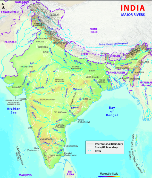
- The drainage system of Indian rivers can be divided into the Himalayan drainage system and the Peninsular drainage system.
The Himalayan Drainage System
- The Himalayan drainage system comprises all the international rivers of India, i.e., the Indus, the Ganga and the Brahmaputra,
- Most of these rivers and their major tributaries are perennial in character, obtaining their water from the glaciers, springs and rains.
- These rivers are in their youthful stage carving out a number of erosional landforms like Waterfalls, cataracts, rapids, gorges, steep-sided valleys, alluvial fans and river terraces.
- The regimes of these rivers exhibit wide seasonal fluctuations, causing devastating floods, especially during the season of general rains.
- Most of the rivers, which rise in the Himalayas are antecedent in nature
- These antecedent rivers existed and flowed before the Himalayas were formed.
Ganga River System
- The Ganga originates as the Bhagirathi from the Gangotri glacier. Before it reaches, Devprayag in the Garhwal Division, the Mandakini, Pindar, Dhauli Ganga and the Bishen Ganga rivers merge into the Alaknanda and the Bheling drain into the Bhagirathi.
- The Pindar river rises from East Trishul and Nanda Devi unites with the Alaknanda at Karnaprayag. The Mandakini meets at Rudraprayag
- The water from both Bhagirathi and the Alaknanda flows in the name of the Ganga at Devprayag
Panch Prayag
- Vishnuprayag Where the river Alaknanda meets river Dhauli Ganga.
- Nandprayag Where river Alaknanda meets river Nandakini.
- Karnaprayag Where river Alaknanda meets river Pindar.
- Rudraprayag Where river Alaknanda meets riverMandakini.
- Devprayag Where river Alaknanda meets river Bhagirathi Ganga.

The Ganga System
| Rivers | Source | Total Length (km) | River Basin (Sq km) | Information |
| Ganga (formed by Alaknanda and Bhagirathi) | Gangotri glacier | 2525 | 861404 | Above Devprayag, it is called as Bhagirathi and below it is referred as the Ganga. Total length of 861404 sq km, largest river basin in India. Covers more than 1/4th of the country’s total surface. Left bank tributaries: Ramganga, Gomati, Ghaghara, Gandak, Burhi Gandak, and Kosi. Right bank tributaries: Yamuna, Son. The Bhagirathi-Hooghly is the Westernmost distributary of the river. Beyond Farakka, it bifurcates itself into Bhagirathi-Hooghly in West Bengal and Padma-Meghana in Bangladesh. |
| Yamuna | Yamunotri glacier | 1376 | 366223 | Rises in Yamunotri glacier, which is West of Ganga source. 1300 km from its source to Allahabad, where it joins Ganga. Feeded by Bandarpunch glacier. Important tributaries: Chambal (rises in Mhow in the Vindhya), Son, Betwa, and Ken. It joins Ganga at Allahabad. |
| Son (right bank tributary of Ganga) | Amarkantak plateau | 780 | 71900 | Rises from the Amarkantak plateau. It joins Ganga near Patna. |
| Ramganga | Kumaun Himalaya | 696 | 32412 | Rises in the Kumaun Himalaya near Nainital. It joins the left bank of Ganga below Farukkhabad. |
| Ghaghara | East of Gangotri | 1080 | 127500 | Rises from East of Gangotri. 127500 sq km more than half of its basin is in Nepal. It joins the left bank of Ganga near Chapra (Bihar). |
| Gomati | Manikot Taala lake | 960 | 30843 | Rises near Manikot from Gomat Taala lake. It is the only tributary of Ganga that originates in plains. It joins the left bank of Ganga near Patna. |
| Saryu | Milam glacier | 350 | – | It demarcates the Western border of Nepal and India. |
| Mahananda | Darjeeling Hills | – | – | It is the last left bank tributary of Ganga. |
| Gandak | Nepal-China border | 360 | 20600 | Rises near the Nepal-China border at an altitude of 7600 m in the Central Himalaya. It flows through the Central part of Nepal, enters Bihar in Champaran district, and turns South-East to join the left bank of Ganga near Sonepur. |
| Kosi (formed by the confluence of the Son, Kosi, Arun Kosi, and Tamur Kosi) | Nepal-Tibet | 730 (in India) | 11600 (in India) | It flows through Eastern Nepal, enters Bihar in Saharsa district, and joins the left bank of Ganga below Bhagalpur (Bihar). |
| Damodar | Chhota Nagpur plateau | 541 | 22000 | It joins the Bhagirathi-Hooghly in West Bengal. It is also known as the Sorrow of Bengal. |
Doab of Ganga River System
| Doab | River Region |
| Ganga Yamuna Doab | Ganga and Yamuna |
| Plain of Rohilkhand | Ramganga and Gomati |
| Awadh Plains | Gomati and Ghaghara |
| Eastern Plains of Uttar Pradesh | Ghaghara and Gandak |
| Sam Plain | Gandak and Old Gandak |
| Mithila Plain | Old Gandak and Kosi |
| Plain of West Bengal | Kosi and Mahananda |
Government Initiatives for Ganga Conservation
Several government initiatives aimed at the rejuvenation of the Ganga river include
- Namami Ganga Programme: Launched in 2014, this flagship program under the Ministry of Jal Shakti focuses on the effective abatement of pollution and the conservation and rejuvenation of the National River Ganga.
- Smart Ganga City: Introduced in 2016 by the Ministry of Water Resources, River Development, and Ganga Rejuvenation, in collaboration with the Ministry of Urban Development, the Smart Ganga City scheme targets ten major cities along the banks of the Ganga, including Haridwar, Rishikesh, Mathura-Vrindavan, Varanasi, Kanpur, Allahabad, Lucknow, Patna, Sahibgunj, and Barrackpore.
- Chitale Committee: Constituted in July 2016 by the Ministry of Water Resources, River Development, and Ganga Rejuvenation, the Chitale Committee was tasked with preparing guidelines for the desolation of the Ganga river from Bhimgauda (Uttarakhand) to Farakka (West Bengal).
The Indus River System
- The Indus, also known as Sindhu, boasts one of the world’s largest river basins, covering an area of 1,165,000 sq km. With a total length of 2,880 km (1,114 km in India), it originates from a glacier near Bokhar Chu in the Tibetan region, within the Kailash mountain range.
- Cutting across the Ladakh range, the Indus forms a gorge near Gilgit in Jammu and Kashmir, with major tributaries including Shyok, Gilgit, Zanskar, Nubra, Shigar, and Dras in the upstream region. It then flows southward, receiving the Panjnad above Mithankot, which comprises the five rivers of Punjab: Sutlej, Beas, Ravi, Chenab, and Jhelum.
- Finally, the Indus discharges into the Arabian Sea east of Karachi, with its presence in India limited to the Leh district in Jammu and Kashmir.
- Notable tributaries like Beas, Jhelum, Chenab, Ravi, and Sutlej contribute to the overall flow of the Indus, each originating from different regions and adding to the river’s vast and intricate system.
The Brahmaputra River System
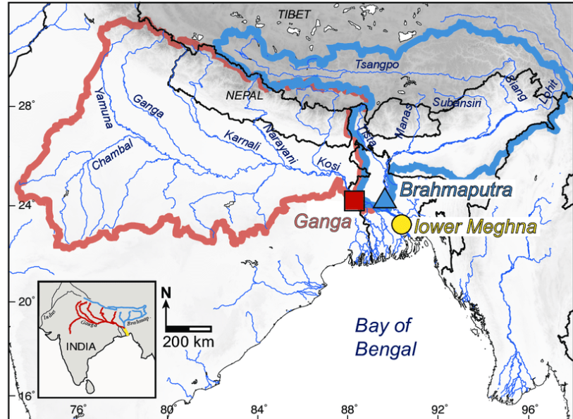
- The Brahmaputra River System Eastward direction. When it Heches Namcha Barwa.
- It flows parallel to the Himalayas in the Fate of Arunachal Pradesh. Here, it is known as the Dihang River.
- In India, it flows through the states of Arunachal Pradesh and Assam and is connected by several
The Brahmaputra System (Brahmaputra and its Tributaries)
| River | Sources | Total Length | River Basins |
| Ganga | Gomukh, Gangotri Glacier in the Himalayas | 2,525 km | 1,086,000 sq km (in India) |
| Brahmaputra | Chemayungdung glacier in the Kailash range | 2,960 km | 240,000 sq km (in India), 580,000 sq km (total) |
- Sankosh River serves as a significant North bank tributary to the Brahmaputra, establishing the boundary between Assam and West Bengal.
- Teesta River, a tributary of the Brahmaputra (known as Jamuna in Bangladesh), flows through India and Bangladesh. Its source lies in the Himalayas near Chunthang, Sikkim, and it courses southward through West Bengal before entering Bangladesh.
- Rangit River, a tributary of the Teesta, holds the distinction of being the largest river in Sikkim, originating within the state. Notably, it is renowned for various water sports activities.
The accurate descending order of the rivers of India by length is as follows:
- Ganga
- Indus
- the Godavari
- Krishna
- the Brahmaputra
- Mahanadi
Major dams Related to Himalaya Rivers
| Dam | State | River |
| Tilaiya Dam | Jharkhand | Barakar |
| Baglihar Dam | Jammu and Kashmir | Chenab |
| Rihand Dam | Uttar Pradesh | Rihand |
| Maithon Dam | Jharkhand | Barakar |
| Pong Dam | Himachal Pradesh | Beas |
| Salal Dam | Jammu and Kashmir | Chenab |
| Uri Dam | Jammu and Kashmir | Jhelum |
| Chamera Dam | Himachal Pradesh | Ravi |
| Dulhasti Dam | Jammu and Kashmir | Chenab |
| Bhakra Nangal Dam | Punjab, Himachal Pradesh | Sutlej |
| Border Dam | Uttarakhand | Bhagirathi |
The Peninsular Drainage System
- The Peninsular drainage system comprises the Mahanadi, the Godavari, the Krishna, the Kaveri and other numerous West flowing rivers.
- The drainage of Peninsular India is much older than that of the Himalayan drainage system. They are mostly seasonal. Their erosional and carrying capacity is low. Their channels are more defined and are close to the base level.
- There are many small rivers in the coastal areas and called coastal rivers. These flow towards the Arabian Sea in the West and towards the Bay of Bengal in the East.
- The major West flowing rivers are Shetrunji, Kalindi, Sharavati, Bhadra, Mandavi, Zuari, Bharathapuzha, Pamba, Periyar, etc. The major east-flowing rivers are Vamsadhara, Brahmani, Baitarani, Subarnarekha, Penneru, Palar, Tamrapani and Vaigai, etc.
The Peninsular River System
| River | Sources | Length (km) | River’s Basin Areas (Sq km) | Informations |
| Godavari | Nashik district of Maharashtra | 1465 | 3.13 lakh | Mahabaleshwar in Sahyadri, Brahmagiri hills in Karnataka |
| Narmada | Rises in Amarkantak in Madhya Pradesh | 1312 | 98796 sq km | Mewar hills in Aravalli range, Vindhya range at an altitude of 500 m, flows through a Rift valley between the Vidhyas and the Satpura range |
| Sabarmati | Rises in the Mewar hills in Aravalli range | 320 | 21674 sq km shared by Rajasthan and Gujarat | Sihawa Mountain, Chhattisgarh, Western slopes of Aravalli ranges |
| Mahi | Western slopes of Aravalli ranges | 583 | 34862 sq km | The Penganga, Indravati, Pranhitra, and the Manjra are its main tributaries, shared by Madhya Pradesh, Rajasthan, and Gujarat |
| Tapti | Rises near Multai on the Satpura range | 724 | 65145 sq km (in Madhya Pradesh, Maharashtra, and Gujarat) | Koyna, Tungabhadra, and Bhima are the major tributaries, Left bank tributaries (Tawa, Burner, etc.), Right bank tributaries (Hiran, Dhuan, Dhar, etc.) |
| Krishna | Mahabaleshwar in Sahyadri | 1401 | 258948 | It receives rainfall from both South-West and North-East Monsoon, Kabini, Bhavan, and Amravati are the important tributaries |
| Chambal | Rises in the Sihawa Mountain, Chhattisgarh | 800 | 81155 | Important tributaries; Hathmati, Sedhi, Wakul, etc. |
| Yamuna | Rises in the Yamunotri glacier in the Himalayas | 1376 | 366223 | Left bank tributaries (Tons, Chambal, Betwa, Ken, etc.), Right bank tributaries (Hindon, Rind, Sengar, etc.) |
| Bhima | Rises in the Bhimashankar hills in Maharashtra | 861 | 70515 | It flows through the Deccan Plateau region |
| Kaveri | Brahmagiri hills Kgad district in Karnataka | 765 | 81155 | It receives rainfall from both South-West and North-East Monsoon, Kabini, Bhavan, and Amravati are the important tributaries |
| Son | Rises in the Amarkantak hills in Madhya Pradesh | 784 | 110,100 | It flows through the states of Madhya Pradesh, Uttar Pradesh, Bihar, and Jharkhand |
| Gandak | Rises in the Nepal Himalayas | 630 | 46,300 | It is a tributary of the Ganges river |
| Mahanadi | Rises in the Sihawa Mountain, Chhattisgarh | 858 | 1.41 lakh | Hirakud dam, the longest Earthen dam in the world, is located on it |
| Luni | Rises in the Aravalli Range | 496 | 37,363 sq km | Largest river system of Rajasthan, its water is brackish below Balotra |
Differences Between the Himalayan and Peninsular Rivers
| Feature | Peninsular Rivers | Himalayan Rivers |
| Perennial or Seasonal | Perennial (linked with glaciers) | Seasonal (South-West Monsoon) |
| Basin Size | Small (e.g., Narmada basin, Tapi basin) | Large (e.g., Ganga basin, Indus basin) |
| River Length | Comparatively smaller | Longer (due to distant water sources) |
| Valley Characteristics | Deep valleys with steep rock sides | Shallow river valleys |
| Flow Destination | Most flow into the ocean (high peninsular slope) | Most flow into the ocean |
| Valley Formation | Form deep valleys and gorges in source areas | River valleys are often shallow |
| Meanders Formation | Form meanders through plains (soft land) | Form meanders through rocky areas |
| Delta Formation | Often form large deltas at mouths | Often form estuaries or small deltas at mouths |
| Drainage Pattern | Antecedent drainage (existing before uplift) | Sequent or consequent drainage (formed after uplift) |
| Source | Name | Mouth |
| Vindhya Range (Kumhra village, Betwa) | Kosi | Ganga |
| Raisen, Madhya Pradesh | Betwa | Yamuna |
| Near Mansarovar Lake | Son | Ganga |
| Betul district, Madhya Pradesh | Narmada | Gulf of Khambat |
| Gulf of Khambat | Tapti | Gulf of Khambat |
| Bay of Bengal | Mahanadi | Bay of Bengal |
| Bay of Bengal | Luni | Rann of Kutch |
| Shiwalik Hills (Himalayas) | Ghaggar | Gulf of Khambat |
| Aravalli Range of the Udaipur district of Rajasthan | Sabarmati | Gulf of Khambat |
| Near Fatehabad | Yamuna (Saraswati) | Gulf of Khambat |
| Near Mahabaleshwar, Jor village (Satara district, Maharashtra) | Krishna | Bay of Bengal |
| Bay of Bengal | Godavari | Bay of Bengal |
| Brahmagiri Mountain, Tryambakeshwar (Nashik, Maharashtra) | Kaveri | Bay of Bengal |
| Talakaveri, Kodagu, Western Ghats, Karnataka | Tungabhadra | Krishna |
| Koodli, Bhadravathi, Karnataka | Krishna River | Bay of Bengal |

List of Major Rivers of India
| Name | Source | Mouth |
| Ganga | Gangotri Glacier | Bay of Bengal |
| Sutlej | Lake Rakshastal in Tibet | Indus |
| Chenab | Glacier near Bokhar Chu in the Tibetan region of the Kailash Mountain range | Arabian Sea |
| Ravi | Chamba district of Himachal Pradesh | Chenab |
| Beas | Beas Kund, Himalayas, Himachal Pradesh | Sutlej |
| Jhelum | Verinag Spring (Pir Panjal Range) | Chenab |
| Yamuna | Yamunotri, Champasar Glacier | Ganga |
| Chambal | Singar Chouri (Mhow in Indore district, Madhya Pradesh) | Yamuna |
| Ghaghara | Mapchachungo Glacier, Tibet, China | Ganga |
Major Towns Situated on the Banks of Rivers
| Town | River |
| Agra | Yamuna |
| Jaunpur | Gomati |
| Ahmedabad | Sabarmati |
| Jagdalpur | Indravati |
| Allahabad | Ganga |
| Ajmer | Luni |
| Kota | Chambal |
| Leh | Indus |
| Betul | Tapti |
| Chamba | Ravi |
| Lucknow | Gomati |
| Cuttack | Mahanadi |
| Ludhiana | Sutlej |
| Delhi | Yamuna |
| Nasik | Godavari |
| Dibrugarh | Brahmaputra |
| Nellore | Pennar |
| Farrukhabad | Ganga |
| Patna | Ganges |
| Guwahati | Brahmaputra |
| Srinagar | Jhelum |
| Haridwar | Ganga |
| Surat | Tapti |
| Hyderabad | Musi |
| Tiruchirapalli | Kaveri |
| Varanasi | Ganga |
Inland Drainage
- Some rivers in India don’t reach the sea or ocean; instead, they discharge water into lakes or inland seas, constituting inland drainage.
- These rivers are mostly found in the drier regions like Western Rajasthan, Ladakh, and Aksai Chin. The Chaggar River serves as a significant example of inland drainage, acting as a seasonal stream flowing on the ancient dried bed of River Saraswati. It forms a boundary between Punjab and Haryana, eventually getting absorbed in the Rajasthan desert.
- Another instance of inland drainage is the River Luni, which rises from the lower slopes of the Himalayas, draining the steep North-West of Aravalli hills, and joining the Rann of Kutch in the left side. Its entire catchment area falls within Rajasthan.
River Regimes
- River regime refers to the annual variation in a river’s discharge—the amount of water flowing through it and how this changes throughout the year. Factors influencing river regimes include changes in the water cycle, temperature, and the characteristics of the drainage basin. Examples of river regimes can be observed in the two Himalayan rivers (Ganga and Jhelum) and two Peninsular rivers (Narmada and Godavari).
Inter-State River Water Disputes
- Despite India’s abundant water resources, the distribution is uneven. Himalayan rivers are large, perennial, and glacier-fed, while Peninsular rivers are seasonal.
- The overwhelming demands of riparian states during dry seasons lead to disputes due to excessive demand, inadequate water supply, and varied utilizations like irrigation and hydropower projects. The Inter-State River Water Disputes (ISRWD) Act of 1956 was enacted by Parliament for adjudication of such disputes.
Major Inter-State River Disputes
| River(s) | States |
| Ravi and Beas | Punjab, Haryana, Rajasthan |
| Narmada | Madhya Pradesh, Gujarat, Maharashtra, Rajasthan |
| Krishna | Maharashtra, Andhra Pradesh, Karnataka, Telangana |
| Godavari | Andhra Pradesh and Odisha |
| Vamsadhara | Andhra Pradesh and Odisha |
| Kaveri | Karnataka, Kerala, Tamil Nadu, and Puducherry |
| Mahanadi | Chhattisgarh, Odisha |
| Mahadayi | Goa, Maharashtra, Karnataka |
| Periyar | Tamil Nadu, Kerala |
National Water Grid
- The National Water Grid, proposed by Dr. KL Rao in 1972, aims to interlink rivers for irrigation and hydro projects. If implemented, it would connect major Himalayan and Peninsular rivers through a network of canals.
- The project involves linking 37 rivers with 30 different canals to redistribute surplus water from Himalayan rivers to water-deficient Peninsular regions. However, environmental concerns and political difficulties pose challenges to the project.
National River Linking Project Plan
The National River Linking Project plans to redistribute river water from surplus to deficit basins. It comprises two components:
- Himalayan Component: Includes 14 projects to link various Himalayan rivers like the Ghaghara-Yamuna link (feasibility study complete).(Feasibility study complete), Yamuna-Rajasthan link, Rajasthan-Sabarmati link, Kosi-Ghaghara link, Kosi-Mechi link, Manas-Sankosh-Tista-Ganga link, Jogighopa-Tista-Farakka link, Ganga-Damodar-Subarnarekha link, Subarnarekha-Mahanadi link, Farakka-Sunderbans link, Gandak-Ganga link, Chunar-Son Barrage link, Son dam-Southern tributaries of Ganga link.
- Peninsular Component Under this segment, 16 projects are enlisted to link various peninsular rivers, including inter-linking Mahanadi-Godavari-Krishna-Palar-Pennar-Kaveri, inter-linking West flowing rivers (North of Mumbai and South of Tapi), inter-linking Ken with Chambal, and diversion of water from West flowing rivers.
Lakes
- A lake is defined as an area of variable size, filled with water, localized in a basin, surrounded by land, without any other rivers or outlets surrounding it.
Lakes can be classified as
- Tectonic Lakes: Formed due to fractures and faults in the Earth’s crust, e.g., Nainital, Bhimtal, Wular, Dal Lake, etc.
- Crater Lakes: Formed when craters and calderas are filled with water, e.g., Lonar Lake in Buldhana.
- Glacial Lakes (Tarns): Resulting from glacial erosion, e.g., Gangabal Lake in Kashmir.
- Fluvial Lakes: Formed by rivers through erosional and depositional work, such as Ox-bow lakes, e.g., in the upper, middle, and lower courses of the Ganga and Brahmaputra rivers, and Kolleru Lake in Andhra Pradesh.
- Aeolian Lakes: Small depressions on wind-blown sand surfaces, e.g., Sambhar and Panchbhadra lakes.
- Lagoons: Formed by depositions of sand bars along the sea coast, e.g., Vembanad, Asthamudi, Kayals of Kerala, and Lake Chilika of Odisha.
Important Lakes in India
| Name | State/UT | Type | Details |
| Pulicat Lake | Andhra Pradesh | Brackish Water | Pulicat Lake Bird Sanctuary; Satish Dhawan Space Centre is located here |
| Kolleru Lake | Andhra Pradesh | Freshwater | Home to migratory birds |
| Nagarjuna Sagar | Andhra Pradesh | Freshwater | Artificially constructed, Krishna river |
| Haflong Lake | Assam | Freshwater | High altitude lake |
| Deepor Beel | Assam | Freshwater | Under Ramsar Convention |
| Kanwar Lake | Bihar | Freshwater | Asia’s largest freshwater Ox-bow lake |
| Hamirsar Lake | Gujarat | Freshwater | Situated in the center of Bhuj |
| Blue Bird Lake | Haryana | Freshwater | Migratory Birds, Wetland Habitat |
| Chandra Taal | Himachal Pradesh | Freshwater | Ramsar wetland site |
| Suraj Taal | Himachal Pradesh | Freshwater | Freshwater |
| Maharana Pratap Sagar | Himachal Pradesh | Freshwater | Bhaga river inflow |
| Prashar Lake | Himachal Pradesh | Freshwater | Ramsar site |
| Renuka Lake | Himachal Pradesh | Freshwater | Holomictic |
| Dal Lake | Jammu and Kashmir | Freshwater | It has a floating Island |
| Pangong Tso | Ladakh | Saltwater | Remnants of past glacial period |
| Wular Lake | Jammu and Kashmir | Freshwater | Indo-China Border |
| Tso Moriri | Ladakh | Freshwater | Tectonic Lake Largest freshwater lake in India |
| Bellandur Lake | Karnataka | Brackish Water | Part of Bellandur drainage system |
| Ashtamudi Kayal | Kerala | Ramsar Wetland | Ramsar wetland site |
| Kuttanad Vembanad | Kerala | Backwater Paddy Cultivation | Brackish water |
| Sasthamkotta | Kerala | Ramsar Wetland | Ramsar site; largest artificial lake in India |
| State/UT | Type | Details | Name |
| Maharashtra | Freshwater | Birdwatching | Salim Ali |
| Maharashtra | Freshwater | Koyna dam | Shivsagar |
| Maharashtra | Crater lake | National Geo-Heritage Monument | Lonar Lake |
| Manipur | Lenticular freshwater | Ramsar wetland; Phumdis (Floating Islands); Multipurpose project | Loktak Lake |
| Odisha | Brackish water | India’s largest brackish water lake; lagoon | Chilika Lake |
| Punjab | Freshwater | Ramsar wetland site | Harike |
| Punjab | Freshwater | Manmade riverine lake | Rupar |
| Punjab | Freshwater | Ramsar wetland site | Kanjil |
| Rajasthan | Saltwater | Ramsar wetland; largest inland saltwater lake in India | Sambhar Lake |
| Rajasthan | Freshwater | Built by Rana Raj Singh | Rajsamand |
| Tamil Nadu | Artificial lake | Boat club, boathouse, and boat service | Kodaikanal Lake |
| Uttar Pradesh | Man-made lake | Govind Ballabh Pant Sagar | |
| Uttar Pradesh | Freshwater | Rihand dam | Bhimtal |
| Uttarakhand | Freshwater | Medium altitude lake | East Calcutta Wetlands |
| West Bengal | Brackish water | Ramsar wetland | – |
Waterfalls
- A waterfall is an area where water flows over a vertical drop or a series of steep drops in the course of a stream or river.
- In India, waterfalls are mostly formed in the upper course of a river where lakes flow into valleys in steep mountains.
List of Major waterfalls in India
| Name | Location |
| Talakona falls | Andhra Pradesh (Tirupati) |
| Tirathgarh falls | Chhattisgarh (Mugabahar river) |
| Chulia falls | Rajasthan (Chambal river) |
| Hundru falls | Jharkhand (Subarnarekha river) |
| Lodh falls | Jharkhand (Budha river) |
| Dudhsagar falls | Goa (Mandovi river) |
| Barkana falls | Karnataka (Sita river) |
| Unchalli falls | Karnataka (Aghanashini river) |
| Gokak falls | Karnataka (Ghataprabha river) |
| Gersoppa (Jog) falls (Highest) | Karnataka (Sharavathi river) |
| Shivasamudram falls | Karnataka (Kaveri river) |
| Palaruvi falls | Kerala |
| Chachai falls | Madhya Pradesh (Bihad river) |
| Rajat Prapat falls | Madhya Pradesh (Pachmarhi) |
| Dhuandhar (Marble) falls | Madhya Pradesh (Narmada river) |
| Nohkalikai falls | Meghalaya |
| Elephant falls | Meghalaya |
| Barehipani falls | Odisha (Budhabalanga river-Simlipal National Park) |
| Khandadhar falls | Odisha (Kaprani stream) |
| Catherine falls | Tamil Nadu |
| Kutralam falls | Tamil Nadu (River Siruvani) |
| Thalaiyar falls | Tamil Nadu (Near Kodaikanal) |
| Birthi falls | Uttarakhand (Panchooli peak) |
| Vasudhara falls | Uttarakhand (near Badrinath) |
| Kapildhara falls | Madhya Pradesh (Narmada river) |
| Jonha (Gautam Dhara) falls | Jharkhand (Ganga river and Raru river) |
| Dassam falls | Jharkhand (Kanchi river) |
Prelims Facts
- The Western part of Teesta river is known as? – Terai /WBCS (Pre) 2019]
- Punarbhava and Atrai are the distributaries of which Rivers?- Teesta [WBCS (Pre) 2020]
- The Confluence of Bhagirathi and Alakananda is located at – Devprayaga [WBCS (Pre) 2021]
- River Beas, flowing from Himachal Pradesh and Punjab, joins the river – Sutlej [UPPSC (Pre) 2015]
- Geomorphologists opine that change of the course of the Kosi river resulted in – Ganga river flowing through Padma in Bangladesh [WBCS (Pre) 2017]
- Baspa, Spiti and Beas are the tributary of the river – Sutlej [UKPSC (Pre) 2022]
- The Main purpose of ‘Ganga Action Plan’ project, launched in 1985 was to – Make it water pollution free [UPPSC (Pre) 2022]
- ‘Moribund delta’ is a subdivision of which delta – Bengal Delta [UPPSC (Pre) 2019]
- In Bangladesh, the Ganga is know by the name of – Padma [UKPSC (Pre) 2005, UPPSC (Mains) 2016]
- From which place the Bhagirathi river originates? – Gaumukh [CGPSC (Pre) 2011, MPPSC 2013)
- The Tributaries of river Yamuna from West to East are – Chambal-Sindh-Betwa-Ken [UPPSC (Pre) 2020]
- Which valley is known for its deep ravine – Chambal [MPPSC (Pre) 2019]
- Which range acts as a water divide between Yamuna and Son? – Kaimur IMPPSC (Pre) 2016]
- Which river joins the Ganga at Fatuha? – Punpun [BPSC (Pre) 2017]
- What is the Indian name of the Yarluny Zangbo river? – Brahmaputra [BPSC (Pre) 2015]
- The river Manas is the tributary of river – Brahmaputra [BPSC (Pre) 2000]
- Rivers like Dibang, Kameng and Lohit are tributaries of – Brahmaputra [IAS (Pre) 2016]
- The most important reason for the construction of the Farakka Barrage was – Raise the Lower Ganges flow [UPPSC (Pre) 2005]
- What is the name of those two rivers which do not form delta? – Narmada and Tapi [MPPSC (Pre) 2013]
- The river Ganga flows into the Bay of Bengal through – A Triangular Delta [WBCS (Pre) 2012)

UPSC NCERT Practice Questions
1. When the rivers discharge their water from all directions in a lake or depression, the pattern is known as
(a) trellis
(b) dendritic
(c) radial
(d) centripetal
2. The rivers of South India mainly have which of the following drainage patterns? UPPSC (Pre) 2014
(a) Radial
(b) Intermittent
(c) Dendritic
(d) Trellis
3. Among the following tributaries, which one is the part of the Ganga river basin? BPSC (Pre) 2019
(a) Sankh
(b) North Koel
(c) South Koel
(d) Barakar
4. Which river flows through the valley of Kashmir? WBCS (Pre) 2013
(a) Sutlej
(b) Ravi
(c) Chenab
(d) Jhelum
5. Which of the following is not a tributary of Brahmaputra river? Manipur PSC (Pre) 2016
(a) Kolong
(b) Sankosh
(c) Kopili
(d) Dhaleshwari
6. Identify the only tributary of river Ganges which rises in the plains.
(a) Son
(b) Sharda or Saryu
(c) Gomati
(d) Ramganga
7. Consider the following tributaries of river Yamuna and arrange them from West to East.
1. Betwa
2. Ken
3. Sindh
4. Chambal
Codes
(a) 4, 3, 1, 2
(b) 1, 2, 3, 4
(c) 3, 2, 1, 4
(d) 2, 3, 1, 4
8. Four rivers have been mentioned below. What will be the decreasing order of these rivers in length (starting from the longest to the shortest)? HPSC (Pre) 2022
1. Mahanadi
2. Krishna
3. Godavari
4. Narmada
Codes
(a) 4, 1, 2, 3
(b) 2, 3, 1, 4
(c) 1, 2, 4, 3
(d) 3, 2, 4, 1
9. Dubbed as the Dakshin Ganga (the Ganges of the South), the largest river of South India is WBCS (Pre) 2021
(a) The Godavari
(b) The Kaveri
(c) The Penganga
(d) The Mahanadi
10. Consider the following rivers. IAS (Pre) 2015
1. Vansadhara
2. Indravati
3. Pranahita
4. Pennar
Which of the following above are tributaries of Godavari?
(a) 1, 2 and 3
(b) 2, 3 and 4
(c) 1, 2 and 4
(d) 2 and 3
11. Consider the following rivers. IAS (Pre) 2015
1. Brahmani
2. Nagavali
3. Subarnarekha
4. Vamsadhara
Which of the above rise from the Eastern ghats?
(a) 1 and 2
(b) 2 and 4
(c) 3 and 4
(d) 1 and 3
12. Which of the following characteristic feature is appropriate for Narmada River? JPSC (Pre) 2021
(a) Wind origin
(b) Structural origin
(c) Glacial origin
(d) Volcanic origin
13. The following characteristics are of which river?
1. Originates from the Aravallis near the fort of Kumbhalgarh.
2. Flows through the Mewar plain.
3. Bedach, Kothari and Morel are its tributaries.
Codes
(a) Champal
(b) Mahi
(c) Banas
(d) Luni
14. The source of the Kaveri river lies in UPPSC (Mains) 2011
(a) Sahyadri
(b) Brahmagiri hills
(C) Gavaligarh hills
(d) Amarkantak
15. Kolleru Lake is located between WBCS (Pre) 2019,2021
(a) Godavari and Kaveri
(b) Godavari and Krishna
(c) Krishna and Kaveri
(d) Mahanadi and Godavar
16. Which of the following statements is correct? UPPSC (Pre) 2023
1. Ram Ganga river joins the Ganga at Kannauj.
2. River Betwa joins the Yamuna near Prayagraj
Codes
(a) Only 2
(b) Neither 1 nor 2
(c) Only 1
(d) Both 1 and 2
17. Chilika Lake is a WBCS (Pre) 2018
(a) saltwater lake
(b) freshwater lake
(c) freshwater lake in the monsoon season
(d) saltwater lake in summer season
18. Hundru fall is formed on BPSC (Pre) 1994
(a) Indravati
(b) Kaveri
(c) Subarnarekha
(d) None of these
19. Consider the following statements TAS (Pre) 2023
1. Jhelum river passes through Wular Lake.
2. Krishna river directly feeds Kolleru Lake.
3. Meandering of the Gandak River formed Kanwar Lake.
How many of the statements given above are correct?
(a) Only one
(b) Only two
(c) All three
(d) None of these
Know Right Answer
1 (d)
2 (c)
3 (b)
4 (d)
5 (d)
6 (c)
7 (a)
8 (d)
9 (a)
10 (d)
11 (b)
12 (b)
13 (c)
14 (b)
15 (b)
16 (c)
17 (d)
18 (c)
19 (a)
Frequently Asked Questions (FAQs)
Q: What is the significance of studying the drainage system of India for UPSC exams?
A: Understanding the drainage system of India is crucial for UPSC exams as it forms a significant part of the geography syllabus. It helps candidates comprehend the geographical features, regional variations, and the impact of rivers on the socio-economic and environmental aspects of the country. Additionally, questions related to river systems often appear in UPSC exams, making it essential for aspirants to have a comprehensive knowledge of India’s drainage system.
Q: Which are the major river systems discussed in UPSC NCERT Geography notes?
A: The major river systems covered in UPSC NCERT Geography notes on the drainage system of India include the Ganges, Brahmaputra, Yamuna, Godavari, Krishna, and the Indus. These rivers play a crucial role in shaping the landscape, supporting agriculture, and influencing settlement patterns across different regions of the country.
Q: How does the drainage system of India impact its agriculture and economy?
A: The drainage system significantly influences agriculture and the economy of India. The fertile alluvial plains formed by rivers like the Ganges and Brahmaputra are major contributors to agricultural productivity. Additionally, the river systems provide water for irrigation, transportation, and various industries, making them integral to India’s economic development. Knowledge of these aspects is important for aspirants preparing for the UPSC exams.
A: UPSC aspirants should be aware of challenges such as water pollution, over-extraction of groundwater, and the impact of dams and irrigation projects on the natural flow of rivers. Understanding these issues is crucial as questions related to environmental concerns and sustainable development are often asked in UPSC exams.
Q: How can the study of the drainage system contribute to disaster management in India?
A: The drainage system is closely linked to natural disasters like floods and droughts. UPSC candidates should be aware of how the geography of river basins and the monsoon patterns contribute to such disasters. Moreover, the knowledge of the drainage system is essential for devising effective disaster management strategies, including early warning systems, flood control measures, and sustainable water resource management, which are important topics for UPSC preparation.

In case you still have your doubts, contact us on 9811333901.
For UPSC Prelims Resources, Click here
For Daily Updates and Study Material:
Join our Telegram Channel – Edukemy for IAS
- 1. Learn through Videos – here
- 2. Be Exam Ready by Practicing Daily MCQs – here
- 3. Daily Newsletter – Get all your Current Affairs Covered – here
- 4. Mains Answer Writing Practice – here