

Contents
- 1 Technology and Infrastructure in Regional Development
- 1.0.1 1. Introduction: The Technological Paradigm in Regional Planning
- 1.0.2 2. Theoretical Frameworks: Time-Space Dynamics and Spatial Interaction
- 1.0.3 3. Sectoral Applications of ICT and Space Technology in India
- 1.0.4 4. The Economic Shift: Post-Fordist Models and Flexible Production
- 1.0.5 5. Navigation and Surveillance: The Strategic Importance of IRNSS/Navic
- 1.0.6 6. Maritime Infrastructure: Ports as Growth Poles and Economic Cores
- 1.0.7 7. Conclusion: The Integrated Future of Regional Planning
- 1.0.8 In case you still have doubts, contact us at 9773890604
Technology and Infrastructure in Regional Development
1. Introduction: The Technological Paradigm in Regional Planning
In the contemporary landscape of regional planning, Information and Communication Technology (ICT) and space technology have transcended their traditional roles as mere utilities. They now function as fundamental catalysts for regional development, serving as the primary drivers of spatial interaction and organisational efficiency. Within modern geographical strategy, these technologies act as sophisticated agents of horizontal and vertical unity, ensuring that developmental interventions are both comprehensive in scope and inclusive in execution. By facilitating a seamless time-space continuum, ICT empowers a shift toward multi-level planning and grassroots participation, where local populations are transformed from passive recipients of central mandates into active architects of their own regional trajectory.
2. Theoretical Frameworks: Time-Space Dynamics and Spatial Interaction
The impact of modern technology on regional development is best understood through the evolution of geographical perceptions regarding distance and interaction. 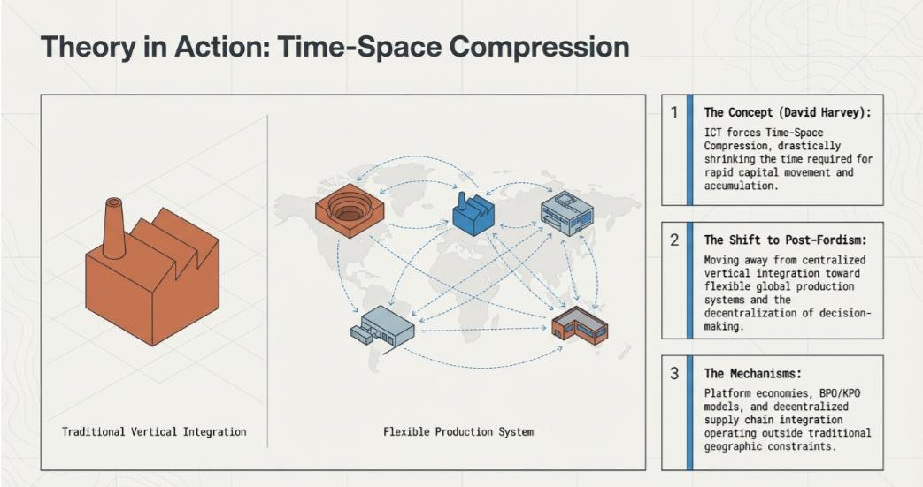
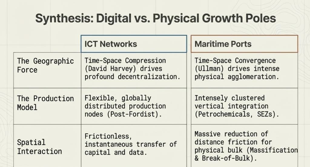
Donald Janelle’s “Time-Space Convergence” highlights the geometric reduction of the “friction of distance,” where advancements in communication effectively bring disparate locations closer in temporal terms. Conversely, David Harvey’s “Time-Space Compression” provides a more radical critique, emphasising how technology enables the decentralisation of production and the rapid accumulation of capital, allowing economic processes to be spread across vast distances while remaining structurally integrated.
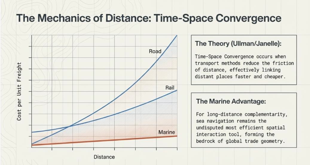
Crucially, these frameworks must be synthesised with Edward Ullman’s triad of spatial interaction: complementarity, transferability, and intervening opportunities. ICT serves as the modern engine of this triad; it identifies and enhances complementarity between regions, increases transferability by reducing information costs, and effectively manages intervening opportunities by providing real-time data on alternative markets and nodes. This digital infrastructure enables a robust multi-level planning environment, allowing instructions and data to flow from national cores to local peripheries, thereby bridging the time-space gap and ensuring that development is a continuous spatial process rather than a fragmented one.
3. Sectoral Applications of ICT and Space Technology in India
The fiscal sustainability and operational efficacy of regional interventions are predicated upon sector-specific technological integration. In the Indian context, the marriage of ICT and space-based Geographic Information Systems (GIS) has revolutionised traditional developmental models:
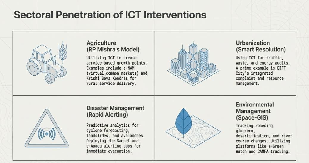
- Agriculture: Space technology, specifically remote sensing, has become indispensable for precision monsoon forecasting and crop monitoring. Aligning with R.P. Mishra’s theoretical model of service-based growth points, the establishment of Krishi Seva Kendras and Krishi Vikas Kendras provides rural landscapes with vital innovation diffusion centres. This is exemplified by “Digital Green Bihar,” where ICT-led extension services have localised agricultural knowledge. Furthermore, the e-NAM platform has created a virtual common market, overcoming spatial barriers to integrate agricultural trade across the subcontinent.
- Urban Development: The “Smart City” paradigm utilises ICT for sophisticated traffic management, waste logistics, and real-time grievance redressal. GIFT City stands as a premier example of an ICT-integrated urban core designed for high-tech economic activities. These technologies are increasingly managing the complexities of emerging urban conurbations, ensuring that density does not result in systemic collapse.
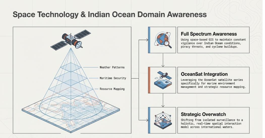
- Disaster and Environment Management: Real-time alerting systems, such as Sachet and Apada, have significantly mitigated the risks associated with cyclones and landslides through early evacuation protocols. In environmental governance, the “e-Green Watch” system provides essential transparency for forest management and CAMPA fund utilisation. Beyond the mainland, OceanSat and the “Indian Ocean Domain Awareness” strategy utilise space-based surveillance to monitor maritime security, piracy, and resource mapping, ensuring the environmental and strategic integrity of India’s blue economy.

4. The Economic Shift: Post-Fordist Models and Flexible Production
The global economy is currently witnessing a strategic departure from the “Fordist” paradigm of centralised vertical integration—the traditional “mining-to-marketing” model where all production stages were geographically co-located. Enabled by ICT, the contemporary “Post-Fordist” model favours decentralised, flexible production systems. In this new spatial arrangement, various stages of the global supply chain are situated in optimal nodes across the planet, linked by near-instantaneous digital interactions. ICT is the primary enabler of this decentralisation, facilitating rapid capital movement and accumulation. This shift has birthed platform economies and propelled the growth of Business Process Outsourcing (BPO) and Knowledge Process Outsourcing (KPO) sectors, where the “Work From Home” culture further diminishes the necessity of physical proximity. Consequently, traditional trade patterns are being redrawn, leading to the economic “Rise of Asia” and the emergence of Tier 2 and Tier 3 cities as new economic cores. By relocating production away from over-congested traditional hubs, ICT ensures a more balanced regional distribution of economic activity.
Strategic autonomy in regional development and national security is increasingly dependent on independent navigation capabilities. With the deployment of the Indian Regional Navigation Satellite System (IRNSS), commercially known as Navic, India has become the fifth country in the world to possess a regional navigation system.
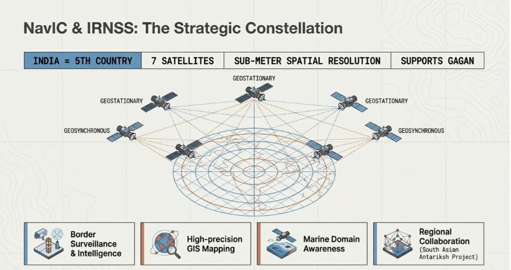
The Navic constellation consists of seven satellites—comprising both geostationary and geosynchronous orbits—providing a standard resolution of five meters and sub-meter accuracy for restricted uses. While Gagan serves as a space-augmentation system primarily for aviation safety, Navic provides the foundational infrastructure for Marine Domain Awareness, border surveillance, and precision intelligence gathering. This technology also serves as a pillar for regional diplomacy through the “South Asian Antariksh Project,” fostering collaborative development and disaster resilience across the subcontinent.
6. Maritime Infrastructure: Ports as Growth Poles and Economic Cores
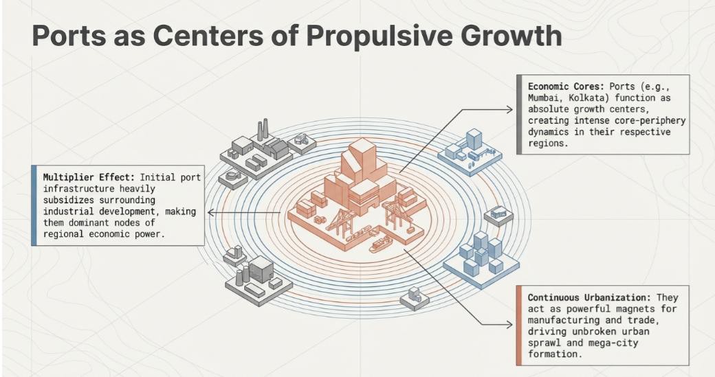
In the modern geography of trade, ports have evolved beyond mere transport nodes to become sophisticated “Growth Poles.” These maritime centres generate propulsive growth and multiplier effects throughout their hinterlands, often acting as the nuclei for vast urban conurbations.
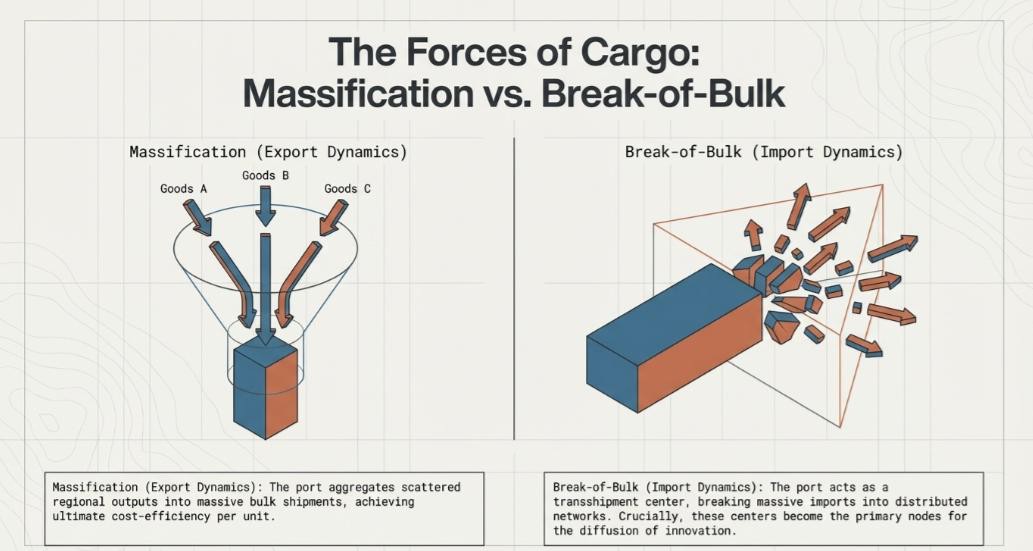
India’s maritime strategy effectively balances “Massification”—the efficient transport of bulk cargo—with “Break-of-Bulk” operations, where transhipment centres distribute large shipments into localised packets.
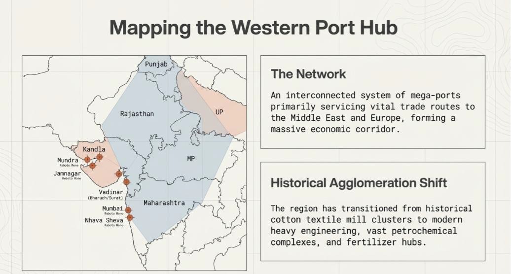
- Western Port Hub: This cluster includes Mundra, Kandla, Jamnagar, and the Mumbai-Nava Sheva complex. This hub is now augmented by the Vadhavan Port in the Palghar district of Maharashtra, which is poised to become one of the world’s largest deep-water terminals. This hub serves as a vital spatial integration point for Punjab, Rajasthan, Western UP, and Maharashtra, linking the Indian heartland to Middle Eastern and European markets.
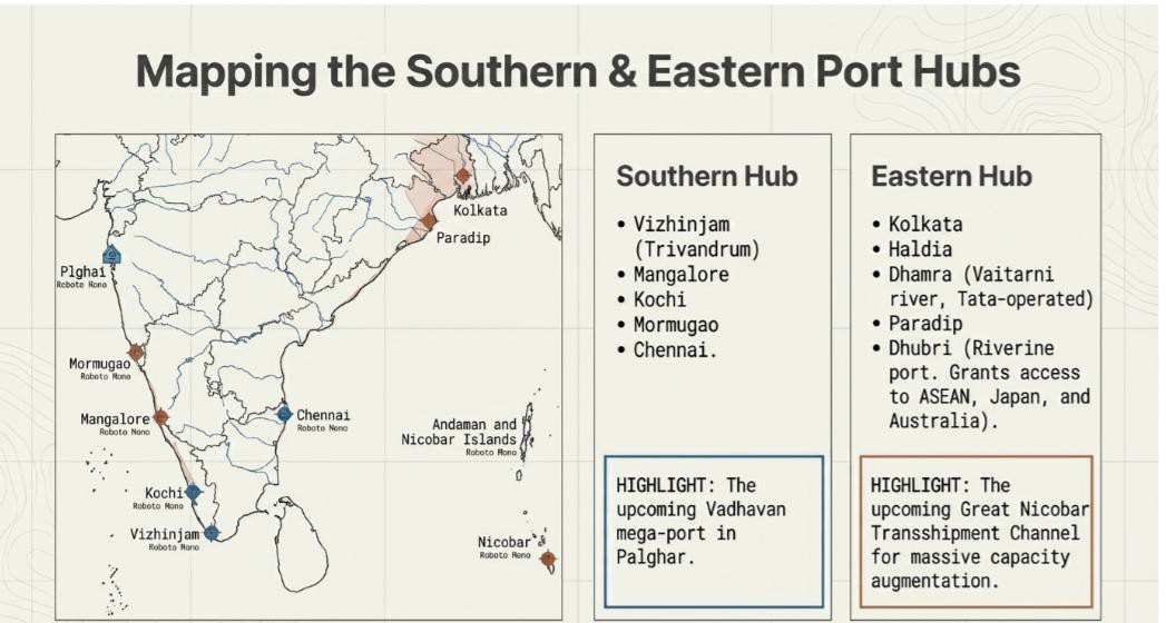
- Southern Port Hub: Centred on Kochi and Chennai, this hub is being significantly enhanced by the Vizhinjam transhipment port. These nodes are critical for capturing the heavy traffic along the East-West international shipping lanes.
- Eastern Port Hub: Comprising Kolkata, Haldia, Paradip, and Dhamra, this hub provides strategic access to ASEAN markets, Australia, and Japan. The addition of the Dhubri Port—a vital multimodal riverine node—ensures the integration of the Northeast into this trade matrix. The hub’s capacity is further bolstered by the Great Nicobar Transhipment Centre, which positions India as a central player in the Bay of Bengal’s maritime architecture.
7. Conclusion: The Integrated Future of Regional Planning
The synergy between ICT, space technology, and physical maritime infrastructure represents the new frontier of regional planning. By successfully mitigating the “Friction of Distance,” these tools have created a spatiotemporal environment where decentralised production coexists with high structural integration. From the precision of Navic’s orbital constellation to the massive transhipment capabilities of the Eastern and Western port hubs, the strategic nexus of technology and infrastructure is the prerequisite for modern development. Ultimately, this integration achieves both horizontal and vertical unity, creating a cohesive national space-economy that is ready for global competition while remaining rooted in local participation.
In case you still have doubts, contact us at 9773890604
Enrol in Geography Optional by Shabbir Sir: Here
Enrol in One-on-One Personalised Mentorship: Here
Enrol in GS Mentorship Program: Here
Enrol In GS Mains Mentorship Program: Here
Explore One Integrated Platform for UPSC Prep: Yooki
Visit our YouTube Channel: Here