Contents
- 1 Halford Mackinder’s Heartland Theory
- 1.0.1 Proponent, Context & Geopolitical Background
- 1.0.2 The Geographical Pivot of History: The 1904 Model
- 1.0.3 The World Island: The Geographical Core
- 1.0.4 Pivot Area: The Continental Land Fortress
- 1.0.5 1. Strategic Depth
- 1.0.6 2. Relative Inaccessibility to Sea Power
- 1.0.7 3. Resources and Mobility
- 1.1 Inner or Marginal Crescent: The Eurasian Rim
- 1.2 Outer or Insular Crescent: Maritime Power
- 1.3 Land Power vs. Sea Power
- 1.4 From Pivot Area to the Heartland Concept
- 1.5 First Revision: The Heartland Model and Dictum (1919)
- 1.6 Second Revision: The Round World and the Winning of the Peace (1943)
- 2 Critical Evaluation of Heartland Theory
- 3 2. Post-World War II Geopolitical Realities: Cold War and Bipolarity
- 4 3. Applications
- 4.1 Geopolitics of Afghanistan and Iran
- 4.1.1 1.1 Afghanistan: Buffer, Barrier and Strategic Crossroads
- 4.1.2 1.2 Soviet Intervention, 1979
- 4.1.3 1.3 Afghanistan and the Cold War Proxy Dimension
- 4.1.4 1.4 Iran: Gateway Between Eurasia and the Indian Ocean
- 4.1.5 1.5 INSTC: Connectivity as Geopolitical Power
- 4.1.6 1.6 Strait of Hormuz: Maritime Chokepoint
- 4.2 China as a Modern, Modified Heartland
- 4.2.0.1 8.1 China: Continental + Maritime Power
- 4.2.0.2 8.2 BRI: Infrastructure as Geopolitical Connectivity
- 4.2.0.3 Mackinderian Interpretation
- 4.2.0.4 8.3 Central Asia: The Eurasian Connector
- 4.2.0.5 8.4 CPEC and Maritime Diversification
- 4.2.0.6 8.5 Institutional Dimension: SCO
- 4.2.0.7 8.6 Western Counter-Moves
- 4.2.0.8 8.7 Multi-Vector Diplomacy in Central Asia
- 4.2.0.9 8.8 Modified Heartland: From Territory to Connectivity
- 5 PYQs
- 6
Halford Mackinder’s Heartland Theory
Proponent, Context & Geopolitical Background
Sir Halford J. Mackinder (1861–1947) was a British geographer and political thinker whose work connected geographical location, transportation, resources and state power. His geopolitical thinking developed within the strategic context of the British Empire, when Britain possessed extensive maritime power and depended heavily upon sea-based communication. 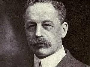 Mackinder was concerned that technological change could weaken the traditional advantage of sea power. The expansion of railways across Eurasia meant that a major continental power could increasingly mobilise resources, people and military forces across the interior without depending upon maritime routes. Core Concern: Could land-based mobility and continental resources challenge the traditional dominance of sea power?
The Geographical Pivot of History: The 1904 Model
Mackinder presented his foundational argument in his 1904 paper, “The Geographical Pivot of History.” At this stage, he used the term Pivot Area rather than the later, more familiar term Heartland. His argument was based on a changing relationship between geographical space and technological mobility. Historically, maritime powers had possessed major advantages in long-distance transportation and global communication. Mackinder argued that the development of railways could reduce the relative disadvantage of continental interiors.
The Central Logic 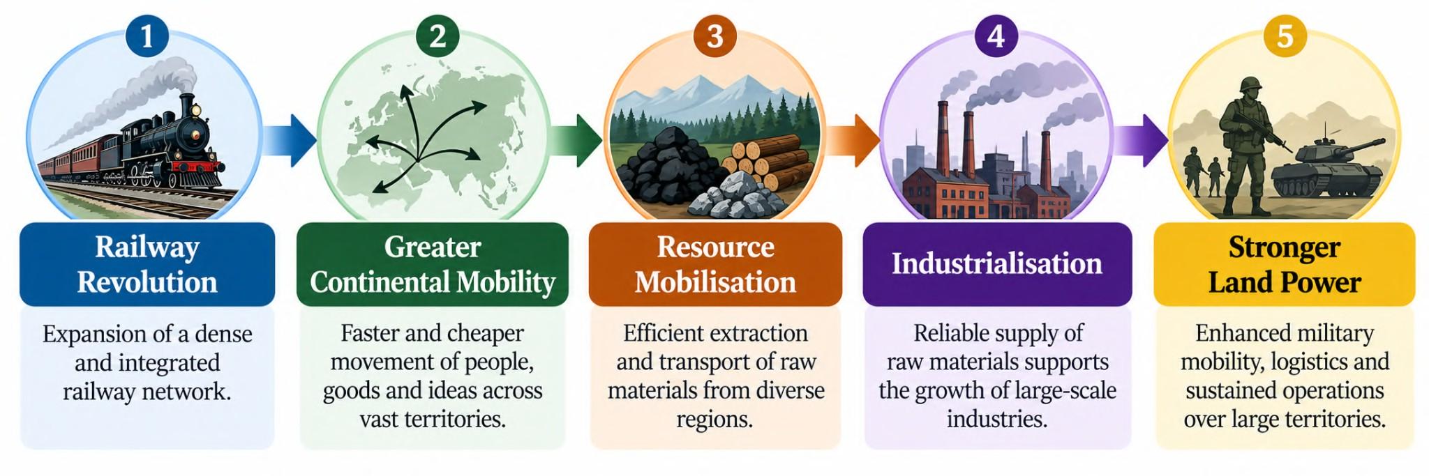 The significance of the argument was therefore not simply that the interior of Eurasia possessed resources. It was the combination of: Location + Resources + Strategic Depth + Land Mobility that gave the Pivot Area potential geopolitical importance.
The World Island: The Geographical Core
Mackinder divided the world into a broad hierarchy of geographical spaces.
World Island
The World Island consisted of the interconnected landmass of Europe, Asia and Africa. For Mackinder, this enormous landmass possessed the greatest concentration of population, resources and economic potential. 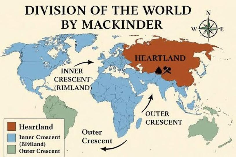 Its significance can be understood through a simple relationship:
World Island = Largest concentration of land + population + resources
Control over the World Island could therefore provide a potential foundation for wider global influence.
The Three-Part Spatial Structure
Within this larger geographical framework, Mackinder identified: Pivot Area → Inner/Marginal Crescent → Outer/Insular Crescent
Pivot Area: The Continental Land Fortress
The Pivot Area occupied the interior of Eurasia, broadly corresponding to parts of Russia and Central Asia. It should not be treated as a precisely bounded collection of modern countries because Mackinder’s geographical boundaries and terminology were different from today’s political map. 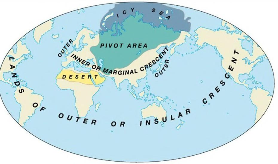
Its importance arose from three interrelated characteristics:
1. Strategic Depth
The enormous continental interior provided strategic depth. A land power operating from this region could potentially absorb military pressure without immediately losing access to its territorial core. The experience of Napoleon’s invasion of Russia illustrated the difficulties faced by an invading power operating deep within the Eurasian interior. However, this was an historical illustration of geographical depth rather than proof that the Pivot Area was inherently unconquerable.
2. Relative Inaccessibility to Sea Power
The interior was comparatively insulated from direct maritime penetration. The Arctic Ocean lay to the north, while major mountain systems and extensive continental distances constrained access from the south. Large inland areas were also separated from the world’s major oceans. Thus: Distance from coast + difficult terrain + continental scale = Strategic insulation
3. Resources and Mobility
Mackinder considered the Eurasian interior significant because of its agricultural land, mineral resources and growing transportation connectivity. Railways could overcome some of the traditional disadvantages of continental interiors by allowing resources and military forces to move across land. The Trans-Siberian Railway, extending across Russia to Vladivostok, became a particularly important illustration of this new continental mobility. 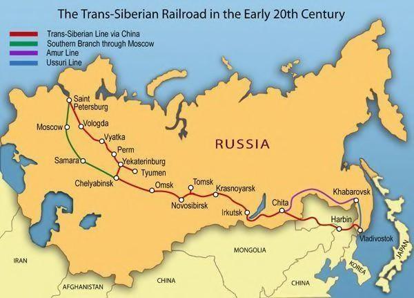 The Trans-Caspian Railway similarly demonstrated the growing penetration of railway networks into Central Asia.
The larger geopolitical significance was:
Railways reduced the relative importance of geographical distance within the continental interior.
Inner or Marginal Crescent: The Eurasian Rim
Surrounding the Pivot Area was the Inner or Marginal Crescent, consisting broadly of the more accessible coastal and transitional regions of Eurasia. These areas possessed greater interaction with both the continental interior and the maritime world. They therefore represented a zone where land power and sea power could come into contact and compete. The Inner Crescent included important regions of Western Europe, the Middle East, South Asia and East Asia. Its exact composition should be understood as a feature of Mackinder’s historical model rather than mapped rigidly onto contemporary political boundaries.
Geopolitical Significance
The Inner Crescent was strategically important because it contained:
Major population centres + industrial regions + agricultural zones + maritime access + land routes
It therefore represented a crucial interface between continental and maritime power.
Pivot Area = Continental Core
Inner Crescent = Strategic Interface
Outer Crescent = Maritime Periphery
Outer or Insular Crescent: Maritime Power
The Outer or Insular Crescent consisted broadly of the major maritime and island powers located beyond the immediate Eurasian continental core. This included Britain, Japan and the major overseas powers, including those of North America and the Southern Hemisphere. These powers derived strategic advantages from:
- Naval mobility
- Maritime trade
- Oceanic communication
- Geographical separation from continental conflicts
For Mackinder, however, the technological transformation represented by railways raised an important question: could maritime isolation continue to provide sufficient protection if continental powers acquired the ability to mobilise resources and forces rapidly across Eurasia? This was the fundamental strategic tension underlying the theory.
Land Power vs. Sea Power
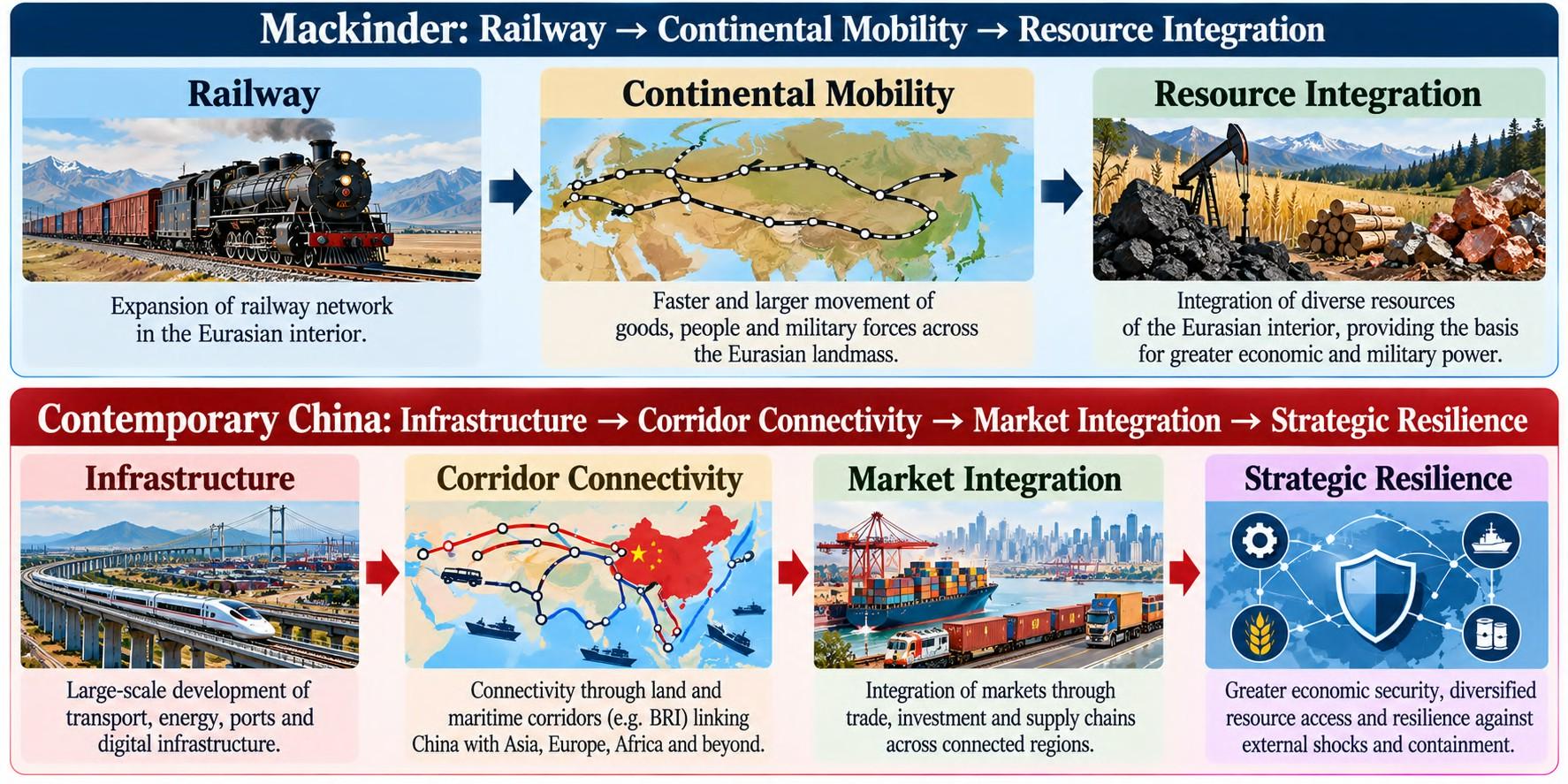
Mackinder’s argument can therefore be understood through the changing balance between land power and sea power. 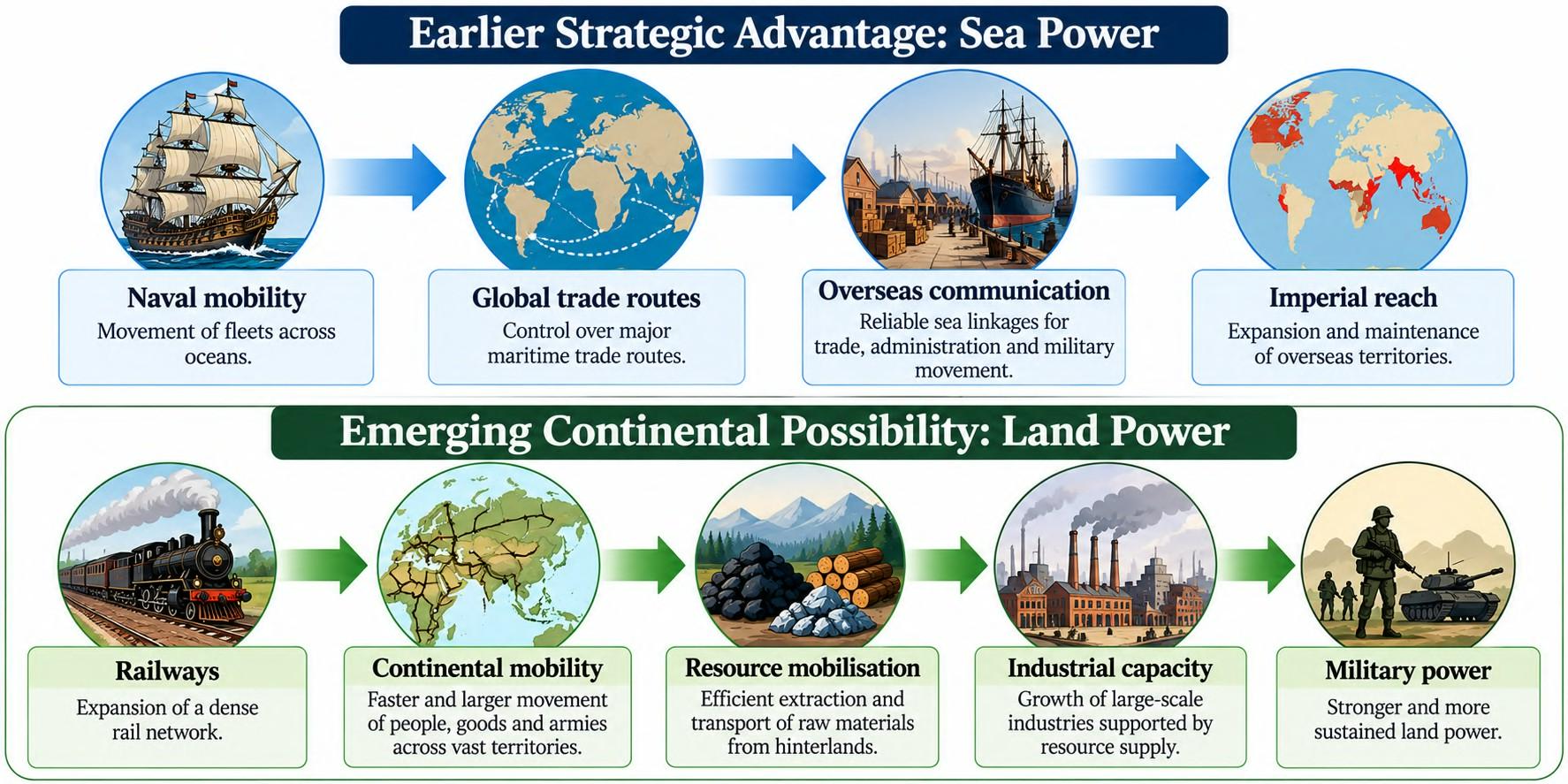 The railway was therefore not merely a transport technology in Mackinder’s argument. It was a geopolitical technology capable of changing the relationship between distance and power. Mackinder did not simply argue that land power would automatically defeat sea power. His deeper argument was that technological change could alter the geographical foundations of geopolitical power. The Eurasian interior, once constrained by distance and poor accessibility, could become strategically significant as railway networks improved.
From Pivot Area to the Heartland Concept
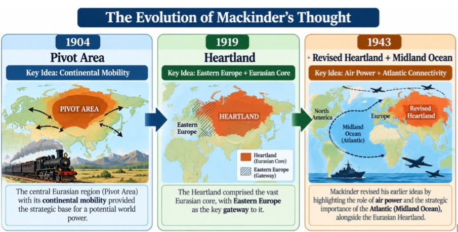
The 1904 Pivot Area became the foundation for Mackinder’s later and more widely known Heartland Theory. In his 1919 work Democratic Ideals and Reality, Mackinder reformulated the concept and used the term Heartland more explicitly. The evolution can therefore be remembered as:
1904: Pivot Area → 1919: Heartland → Geopolitical Control of Eurasian Core
This distinction is important because the 1904 model and the later Heartland formulation are related but not identical. The central proposition that emerged from Mackinder’s thinking was:
Control of the Eurasian core could provide a powerful geographical foundation for control over the wider World Island. This leads directly to the famous Heartland dictum, which connects the control of Eastern Europe, the Heartland, the World Island and ultimately the wider world system. Mackinder’s framework can ultimately be reduced to four geographical keywords:
Location → Mobility → Resources → Power
The theory therefore represents an attempt to explain global power through the spatial organisation of Eurasia, especially the relationship between its continental core, surrounding marginal regions and maritime periphery.
First Revision: The Heartland Model and Dictum (1919)
The experience of World War I, the collapse of the Russian Empire, and the emergence of revolutionary Russia led Mackinder to reconsider the geographical boundaries and strategic meaning of his earlier Pivot Area. In Democratic Ideals and Reality (1919), he retained the basic logic of continental power but refined the concept into the Heartland.
Pivot Area → Heartland
The major conceptual change was the replacement of the Pivot Area with the broader Heartland. Mackinder extended the strategically important area westward because land power could potentially close or control access to the Baltic and Black Seas. His 1919 formulation therefore placed greater emphasis on the relationship between the Eurasian interior and Eastern Europe.
1904: Pivot Area → Eurasian continental interior
1919: Heartland → Expanded continental core + strategically important adjoining areas
The important geographical principle was accessibility: areas that could be effectively controlled from the continental interior became strategically connected to the Heartland.
Eastern Europe: The Strategic Gateway
For Mackinder, Eastern Europe acquired exceptional importance because it formed the geographical interface between the Heartland and the rest of Europe. Its plains, population, agricultural resources and industrial potential made it more than a peripheral zone. The strategic concern was the possibility of a powerful state or coalition establishing control over Eastern Europe and the Eurasian interior simultaneously.
Eastern Europe → Gateway to Heartland → Heartland → World-Island
Mackinder’s concern was therefore not that possession of Eastern Europe mechanically produced world domination, but that control of this region could provide a favourable strategic route towards organising the Heartland. His 1919 argument was also closely connected with the post-war political reconstruction of Europe and the creation of a balance between Germany and Russia.
 Mackinder’s Famous Dictum
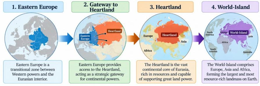
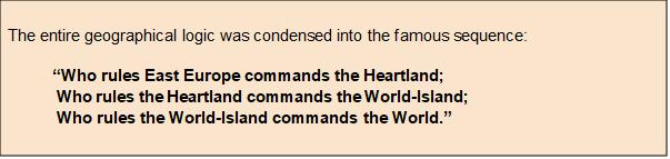 The dictum should therefore be understood as a geopolitical hypothesis about the concentration of strategic resources and mobility, rather than as a literal law that guarantees global domination.
The “Door and Room” Logic
Mackinder’s 1919 formulation gave particular importance to the Baltic and Black Seas because land power could potentially restrict access to these enclosed or semi-enclosed seas. His argument was explicitly concerned with how the geography of land power could constrain maritime access.
Open Ocean
↓
Strategic Straits /
Access Points
↓
Baltic or Black Sea
↓
Heartland
The Bosphorus–Dardanelles system is especially important in the Black Sea context because the straits connect the Black Sea with the Mediterranean through the Sea of Marmara. 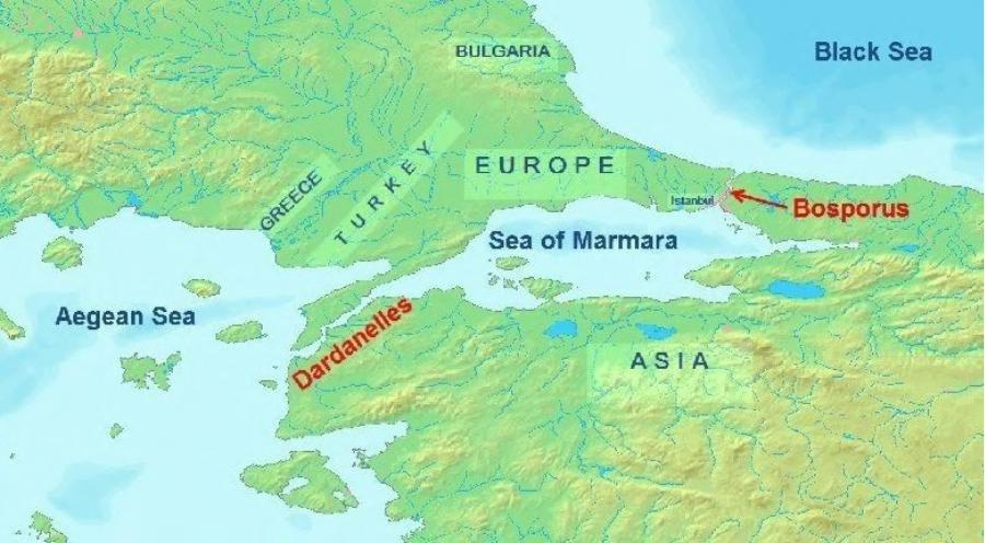 Thus, the geographical relationship can be remembered as:
Straits = Door | Enclosed Sea = Room | Continental Interior = Core
This illustrates a broader Mackinderian theme: control of strategic access points can extend the influence of land power beyond the immediate continental interior. The 1919 revision transformed Mackinder’s argument from a relatively broad continental Pivot into a more politically focused Heartland strategy. The crucial relationship became:
Eastern Europe → Access to Heartland → Organisation of Eurasian resources → Potential global power
Second Revision: The Round World and the Winning of the Peace (1943)
By 1943, the strategic environment had changed dramatically. World War II, the emergence of air power, the growing industrial capacity of the United States, and the changing nature of warfare required another revision of Mackinder’s geographical framework. His final major formulation appeared in the essay “The Round World and the Winning of the Peace,” published in Foreign Affairs in July 1943.
Heartland and Lenaland
Mackinder now distinguished the Heartland from Lenaland, the sparsely populated territory east of the Yenisey River towards the Lena basin. His reasoning was based primarily on:
Sparse population + severe climate + difficult terrain + weak social/economic integration
Mackinder therefore excluded Lenaland from the core Heartland concept rather than treating the whole of Siberia as equally strategically integrated.
Spatial Logic
Yenisei River became an important eastern reference for distinguishing:
Heartland → More integrated continental core from Lenaland → More remote and sparsely populated eastern region
This demonstrates an important feature of Mackinder’s later thinking: geographical area alone was insufficient; population, mobility and integration also mattered.
The Midland Ocean: Atlantic Power Re-enters the Model The most important innovation of the 1943 formulation was the greater significance given to the North Atlantic, which Mackinder termed the Midland Ocean. 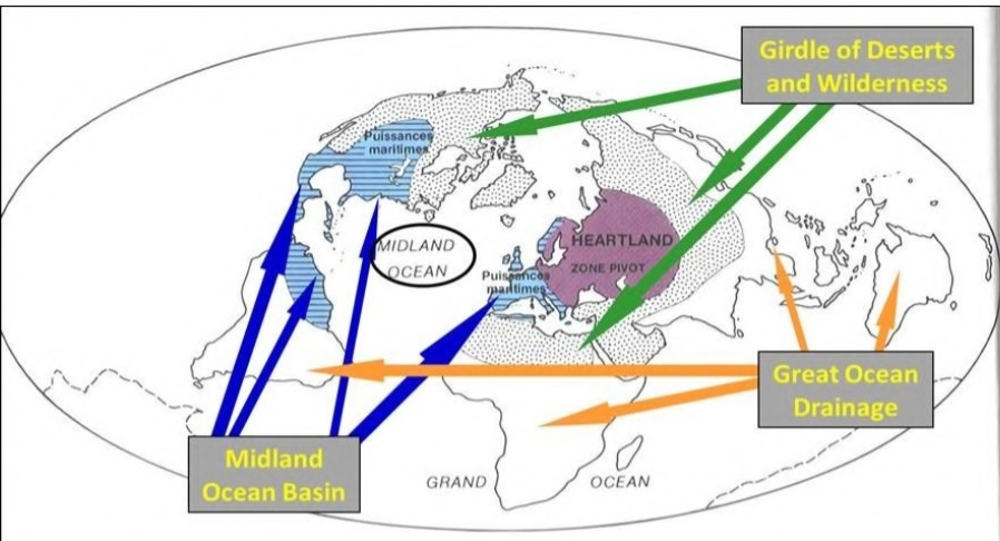 The rise of air power and transatlantic logistics weakened the geographical separation between North America and Europe. Mackinder conceptualised a strategic system linking:
United States + Canada + Britain + Western Europe
The North Atlantic was therefore no longer simply a barrier separating maritime powers. It could function as an interconnected strategic space. Mackinder described Britain as a “moated aerodrome” and France as a bridgehead, emphasising the strategic value of their geographical positions within an Atlantic system. The 1943 model therefore introduced a more complex balance:
Heartland / Continental Power ↔ Midland Ocean / Atlantic Power
Rather than simply predicting the triumph of land power over sea power, Mackinder increasingly recognised the importance of air power, industrial capacity and transatlantic connectivity. The framework subsequently influenced later strategic thinking about the relationship between Eurasian continental power and Atlantic powers, although it would be too strong to describe Mackinder’s 1943 formulation as directly creating NATO. It is more accurate to say that his ideas were later drawn upon in Cold War geopolitical thinking.
Critical Evaluation of Heartland Theory
Mackinder’s theory remains important because it introduced a powerful way of thinking about space, resources, mobility and strategic power. However, its assumptions also create significant limitations.
1. Geographical Determinism
The strongest criticism is the tendency to give geographical location an excessive causal role. Modern geopolitics demonstrates that outcomes also depend upon:
Institutions + Leadership + Economy + Technology + Diplomacy + Political legitimacy
The collapse of the Soviet Union in 1991 illustrates this limitation. Possession of the geographical Heartland did not prevent political and economic problems within the Soviet system from contributing to its eventual dissolution. Geography creates possibilities; it does not automatically determine outcomes.
2. Technological Change
Mackinder’s original framework was strongly influenced by the technological transition from maritime mobility to railway mobility. Subsequent technological developments have transformed the meaning of distance and accessibility. Railways → Air Power → Missiles → Satellites → Cyber Networks → Autonomous Systems
Long-range aircraft, ballistic missiles, satellites, drones and cyber capabilities allow states to project power across geographical barriers in ways that were difficult to incorporate into early twentieth-century geopolitical models. Therefore:
Strategic depth remains important, but physical inaccessibility no longer guarantees security.
1. The Eastern European Dictum: Historical Qualification
Historical experience also demonstrates that Mackinder’s dictum should not be treated as a deterministic law. Nazi Germany occupied or dominated large parts of Eastern Europe during World War II but did not achieve control of the Heartland or global domination. Similarly, the Soviet Union established extensive political and military influence across Eastern Europe after World War II, yet this did not translate into control of the entire World-Island or the world. The historical record, therefore, suggests that control of a geographical region is only one component of geopolitical power.
2. Changing Sources of Global Power
Contemporary power is distributed through multiple interconnected systems rather than territorial control alone. 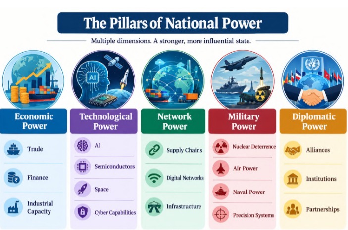 Thus, the contemporary geopolitical landscape cannot be explained adequately through Heartland control alone. Mackinder’s enduring contribution lies in showing that geographical space is not merely a passive backdrop to international politics. The location of resources, transport corridors, barriers, coastlines and strategic gateways can influence the distribution of power. Yet the later history of the twentieth and twenty-first centuries also demonstrates that these geographical possibilities are mediated by technology, institutions, economics, diplomacy and human agency. This makes Heartland Theory most useful today as a framework for analysing the strategic significance of Eurasian space, rather than as a deterministic formula for predicting global domination.
2. Post-World War II Geopolitical Realities: Cold War and Bipolarity
The end of World War II transformed the geopolitical structure of the world. European powers emerged economically and militarily weakened, while the United States and Soviet Union became the two principal centres of global power. The U.S. Office of the Historian describes the early post-war period as one in which Soviet domination of Eastern Europe and the Western response contributed to the emerging Cold War confrontation.
2.1 Post-War Power Vacuum
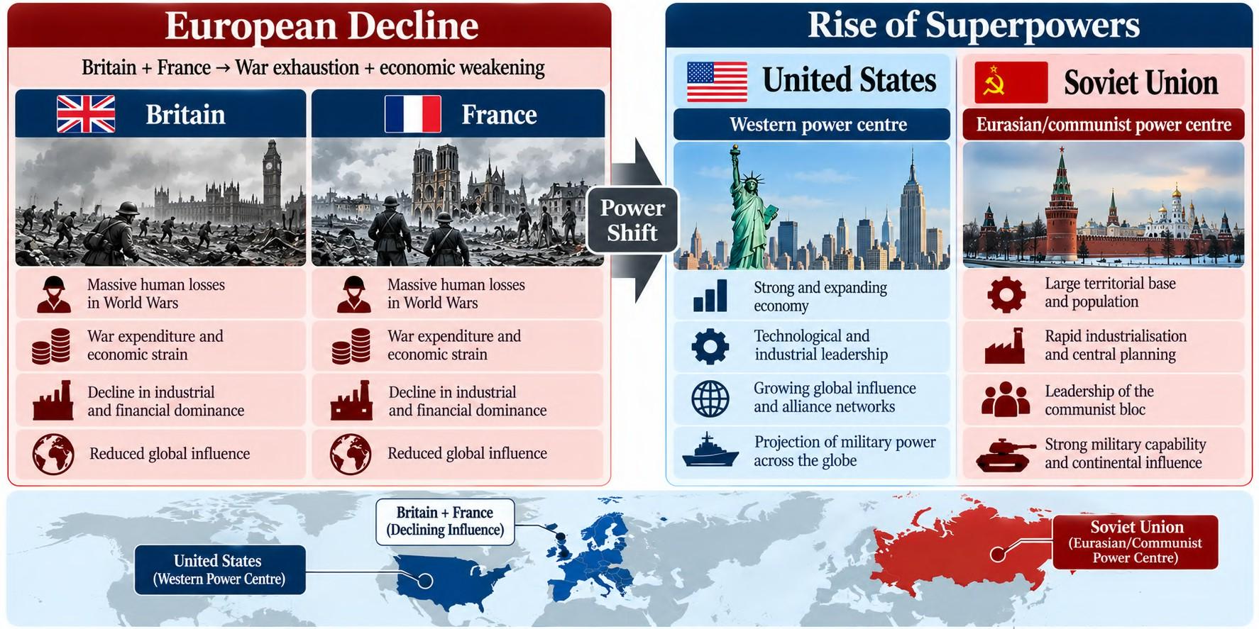 The result was a transition from a predominantly multipolar European balance towards a bipolar international system.
2.2 Eastern Europe: Security Buffer and Sphere of Influence
For the Soviet Union, Eastern Europe had major security significance because it provided strategic depth between Soviet territory and Western Europe. At the same time, Soviet influence in the region developed through political, military and economic mechanisms. U.S. archival assessments explicitly described Eastern Europe as a Soviet sphere of influence and a strategic buffer. Thus, the geopolitical logic can be represented as:
Soviet Heartland
↓
Eastern European Buffer
↓
Western Europe
↓
Atlantic Powers
This bears a conceptual resemblance to Mackinder’s concern with Eastern Europe as the gateway to the Eurasian core, although Cold War geopolitics cannot be reduced to Heartland theory alone.
2.3 Bipolar Ideological Structure
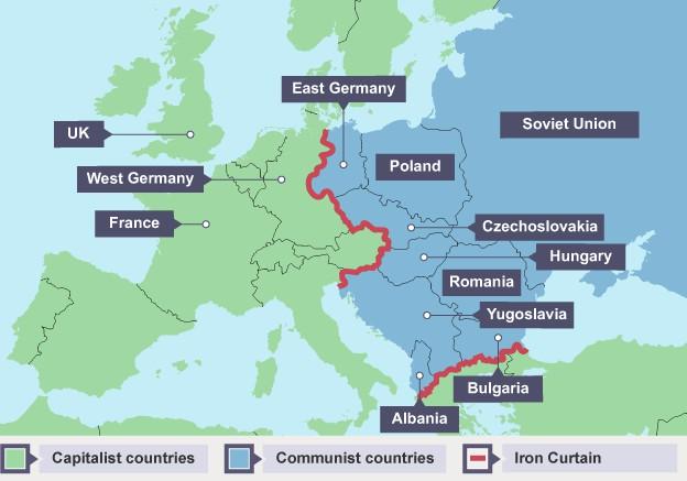
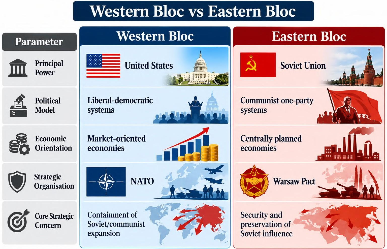 The Cold War combined geopolitical rivalry with ideological competition. NATO was established in 1949 as a collective-security alliance involving the United States, Canada and Western European states. The Warsaw Pact followed in 1955, linking the Soviet Union with several Eastern European states. Containment and Counter-Containment The resulting system was characterised by:
NATO → Western collective security Warsaw Pact → Eastern collective security Nuclear deterrence → Strategic restraint Ideological rivalry → Global competition 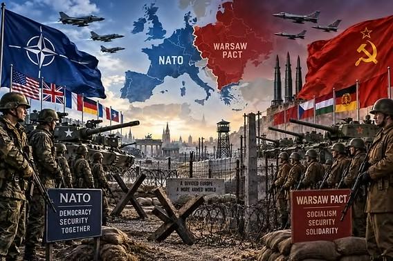 The Cold War, therefore, transformed Mackinder’s broad land-power versus sea-power framework into a more complex contest involving territory, ideology, military alliances, industrial capacity and nuclear deterrence.
2.4 The Geopolitical Synthesis
The progression can now be connected:
Mackinder: Heartland → Eastern Europe → Eurasian Power
Cold War: Soviet Eurasian Core → Eastern European Buffer → NATO Containment
But the Cold War also demonstrated the limits of a purely geographical explanation. Nuclear weapons, industrial capacity, ideological alliances, economic assistance and technological competition became critical determinants of power. The formation of NATO and the Warsaw Pact institutionalised the bipolar structure rather than simply reproducing a classical land–sea rivalry.
3. Applications
Encirclement and the Russia–Ukraine Conflict
The Russia–Ukraine conflict provides a contemporary case for applying Mackinder’s ideas of Heartland security, strategic depth, Eastern European access and maritime connectivity. Ukraine’s geographical position between Russia and the European security system makes it an important strategic space, although the conflict cannot be explained by Heartland theory alone.
3.1 Ukraine as a Strategic Node
Geographical Position
Ukraine occupies a broad East European plain, connecting the Russian interior with Central and Eastern Europe. Its significance arises from:
Broad plains + proximity to Russia + European connectivity + Black Sea access
Unlike mountain-frontier regions, the Ukrainian landscape contains extensive low-relief terrain, making mobility and depth important military-geographical considerations.
Economic and Agricultural Significance
Ukraine possesses highly productive chernozem soils and historically significant agricultural production, particularly cereals and oilseeds. It is therefore better described as a major agricultural producer/exporter rather than literally the “Granary of the World.” 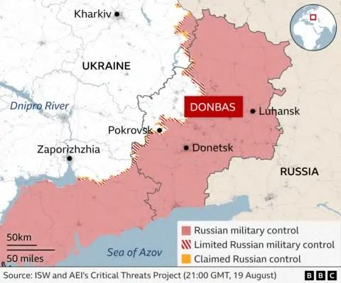
Industrial and Mineral Geography
The Donbas/Donetsk region has historically been associated with coal mining and heavy industry. Its significance illustrates Mackinder’s broader concern with the relationship between:
Resources → Industrial Capacity → Strategic Power
Black Sea Access
Ukraine’s Black Sea coastline gives it access to maritime trade routes.
Odesa → Black Sea → Bosporus → Mediterranean → Global Maritime System Crimea,
meanwhile, has major strategic significance because of its location in the Black Sea and the naval facilities around Sevastopol.
3.2 NATO and the Eastern European Security Space
The post-Cold War expansion of NATO altered the strategic geography of Eastern Europe. Poland, Romania, Bulgaria and the Baltic states became NATO members, while Ukraine remained outside the alliance but developed increasingly close relations with it. At the 2008 Bucharest Summit, NATO formally stated that Ukraine and Georgia would eventually become members, although Ukraine did not receive immediate membership or a Membership Action Plan. This distinction is important: 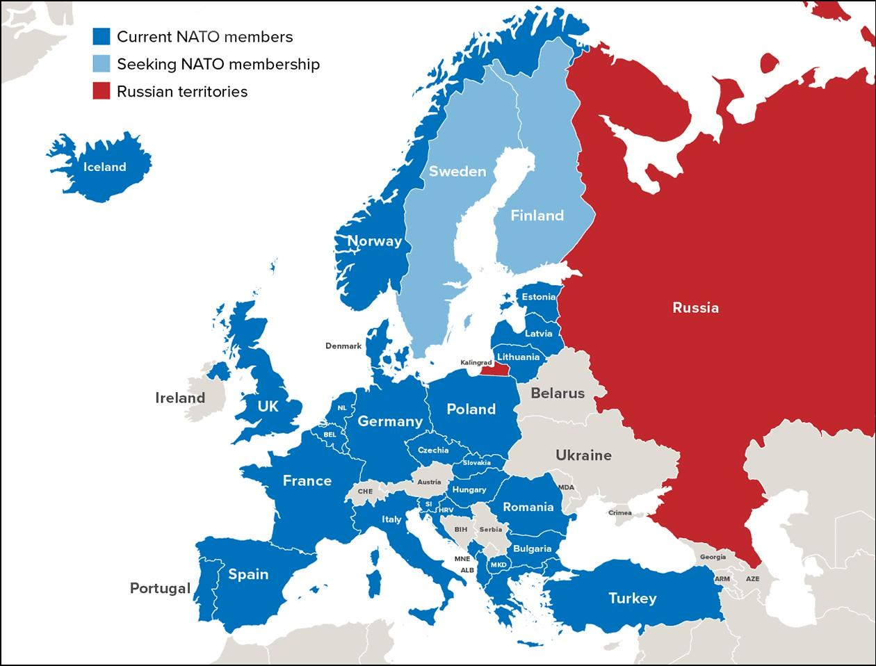 NATO aspiration ≠ NATO membership
Heartland Interpretation From a Mackinderian perspective:
Russian continental core
↓
Eastern European strategic belt
↓
NATO security space
This can be interpreted as a contemporary form of strategic competition over the European approaches to the Eurasian interior. However, the conflict also involves Ukrainian sovereignty, Russian-Ukrainian historical relations, domestic politics, European integration, military strategy and international law. Heartland theory provides one analytical lens, not a complete explanation.
3.3 Russia’s Security Concerns and the 2014–2022 Escalation
The Russia–Ukraine conflict did not begin in 2022. 2014 marked a major escalation, including Russia’s annexation of Crimea and the conflict in Donbas; the February 2022 full-scale invasion dramatically expanded the war. Russian leaders have repeatedly identified NATO expansion and Ukraine’s potential NATO membership as major security concerns. Western governments, meanwhile, have rejected the idea that Russia should have a veto over the sovereign foreign-policy choices of neighbouring states.
Geopolitical Interpretation
The Heartland framework highlights three strategic concerns: 1. Buffer Space Ukraine’s location between Russia and NATO states. 2. Strategic Depth The importance of distance and territorial space between the Russian core and potential military threats. 3. Black Sea Access The strategic value of Crimea and Russia’s naval position.
Thus:
Ukraine = Eastern European strategic node + agricultural/industrial space + Black Sea gateway
3.4 Strategic Backfire: Finland and Sweden
An important geopolitical consequence was the strengthening of NATO rather than its weakening. Russia’s 2022 invasion contributed to a major reassessment of security policy in Finland and Sweden. Finland joined NATO in 2023, followed by Sweden in 2024. The result can be represented as:
Russian security concerns about NATO expansion
↓
Full-scale invasion
↓
Greater European security mobilisation
↓
Finland + Sweden join NATO
This illustrates a broader geopolitical principle:
Attempts to prevent strategic encirclement can sometimes produce counter-mobilisation. The Russia–Ukraine case demonstrates that Mackinder’s ideas remain useful for analysing strategic depth, Eastern European access and continental–maritime competition. However, Heartland Theory explains geographical incentives; it does not by itself explain political decisions or determine outcomes.
Geopolitics of Afghanistan and Iran
The Afghanistan–Iran region demonstrates another dimension of Heartland geopolitics: the importance of the southern approaches to Eurasia, mountain barriers, transport corridors and access to warm-water maritime systems. 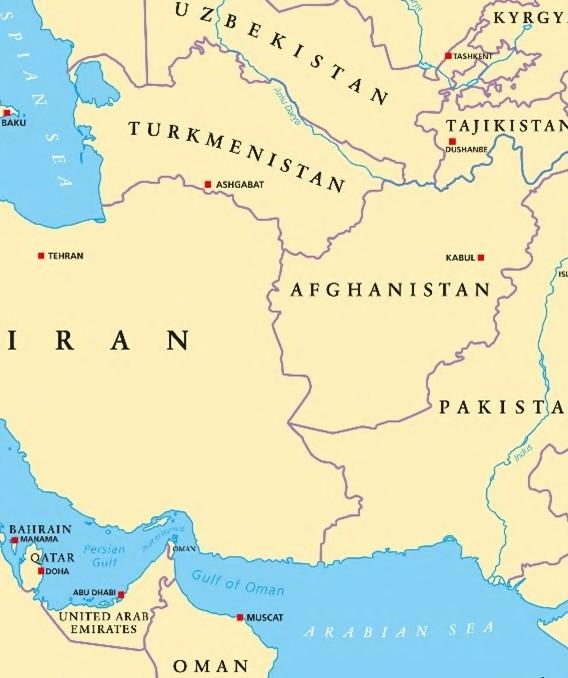
1.1 Afghanistan: Buffer, Barrier and Strategic Crossroads
Geographical Position
Afghanistan lies between: Central Asia + Iran + Pakistan + South Asia
Its location has historically made it a strategic crossroads between major continental regions.
Terrain as Strategic Defence
Afghanistan’s: Mountains + narrow valleys + rugged terrain + dispersed settlements
create major difficulties for external military powers attempting sustained territorial control. This makes Afghanistan a useful example of:
Terrain → Friction → Limited Mobility → Difficult Occupation
1.2 Soviet Intervention, 1979
The Soviet intervention in December 1979 is sometimes explained through the idea of Soviet expansion towards the Persian Gulf and warm-water routes. However, contemporary U.S. intelligence assessments found stronger evidence for more immediate concerns: protecting the pro-Soviet Afghan regime, preventing an insurgent victory, removing Hafizullah Amin and avoiding the emergence of a hostile government on the Soviet southern frontier.
1.3 Afghanistan and the Cold War Proxy Dimension
The Soviet intervention transformed Afghanistan into a major
Cold War conflict zone. Soviet intervention
↓
Anti-Soviet insurgency
↓
U.S. and allied support to Afghan Mujahideen
↓
Prolonged conflict
↓
Regional and international consequences
The United States pursued a containment strategy, while Pakistan became a major channel for assistance to Afghan insurgent groups. The conflict subsequently contributed to prolonged instability whose consequences extended far beyond the Cold War. The geographical lesson is:
Strategic location + difficult terrain + external intervention → Prolonged geopolitical competition
1.4 Iran: Gateway Between Eurasia and the Indian Ocean
Iran occupies a distinctive geographical position between:
Central Asia + Eurasia + Persian Gulf + Indian Ocean
Its location provides potential connectivity between continental markets and maritime routes. Warm-Water Connectivity Iran’s southern coastline provides access to the Persian Gulf and Gulf of Oman, while the country’s land routes connect towards Central Asia and the Caucasus. This creates a geographical combination of:
Continental Corridor + Maritime Gateway
1.5 INSTC: Connectivity as Geopolitical Power
The International North–South Transport Corridor (INSTC) illustrates how infrastructure can convert geographical location into strategic connectivity. 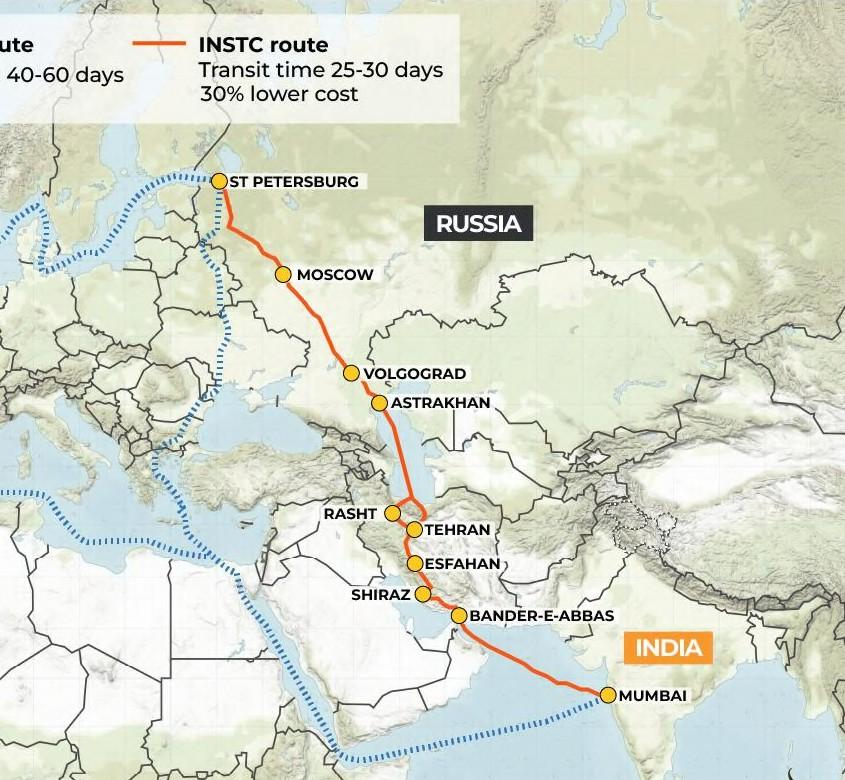 The corridor links:
India → Iran → Caspian Sea → Russia → Northern Europe
India’s official description envisages a multimodal route involving sea, road, rail and Caspian shipping, with Chabahar providing an important Indian Ocean connection. Thus:
Infrastructure → Accessibility → Connectivity → Strategic Leverage
1.6 Strait of Hormuz: Maritime Chokepoint
Iran’s geographical position also provides proximity to the Strait of Hormuz, connecting the Persian Gulf with the Gulf of Oman and Arabian Sea. The Strait remains one of the world’s most important energy chokepoints. EIA data show that approximately 20.7 million barrels per day of oil passed through Hormuz in 2024, equivalent to roughly one-fifth of global petroleum-liquids consumption. 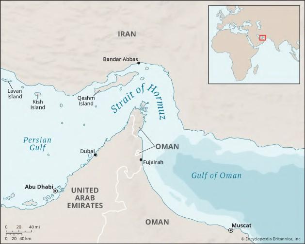
Strategic Chain
Persian Gulf energy resources
↓
Strait of Hormuz
↓
Arabian Sea
↓
Indian Ocean
↓
Global Energy Markets
This demonstrates that geopolitical significance can emerge not only from territorial control, but also from the ability to influence critical flows and chokepoints. Afghanistan and Iran reveal two different forms of geopolitical significance:
Afghanistan → Terrain + Buffer + Security Frontier Iran → Corridor + Gateway + Chokepoint
Together, they demonstrate that the southern Eurasian rim is strategically important because it connects continental power with maritime access.
China as a Modern, Modified Heartland
China provides a useful contemporary extension of Mackinder’s framework, although it should not literally be equated with the Heartland. 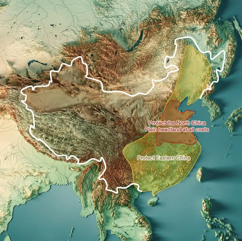 China combines the characteristics of a major continental power and maritime power, making it a hybrid geopolitical actor.
8.1 China: Continental + Maritime Power
Unlike Russia’s predominantly continental geographical orientation, China possesses:
Large continental territory + Central Asian connectivity + Pacific coastline + Major ports
This produces a hybrid spatial structure:
Land Power + Sea Power = Hybrid Geopolitical Capability
China’s significance therefore lies not merely in its territorial location, but in its ability to connect Eurasian land corridors with global maritime networks.
8.2 BRI: Infrastructure as Geopolitical Connectivity
The Belt and Road Initiative (BRI) provides a contemporary example of infrastructure being used to strengthen connectivity across Eurasia. Its geographical instruments include:
Railways + Roads + Pipelines + Ports + Logistics Hubs + Dry Ports
The objective is not simply territorial control. It is the creation of networks connecting production centres, markets and transport corridors.
Mackinderian Interpretation
8.3 Central Asia: The Eurasian Connector
Central Asia has become an important geographical interface between China, Russia, Europe and West Asia. The Khorgos Gateway on the China–Kazakhstan border illustrates the role of dry ports and logistics hubs in reducing border and trans-shipment barriers along China–Europe routes. The World Bank identifies Khorgos as a major transport node intended to facilitate trade between China and Europe.
Energy Connectivity
China has also developed extensive energy connections with Central Asia, strengthening the relationship between: Resource-producing states → Pipelines → Chinese markets
This converts geographical proximity into economic and energy connectivity.
8.4 CPEC and Maritime Diversification
The China–Pakistan Economic Corridor (CPEC) provides another example of China’s attempt to connect its western interior with the Arabian Sea through Pakistan. 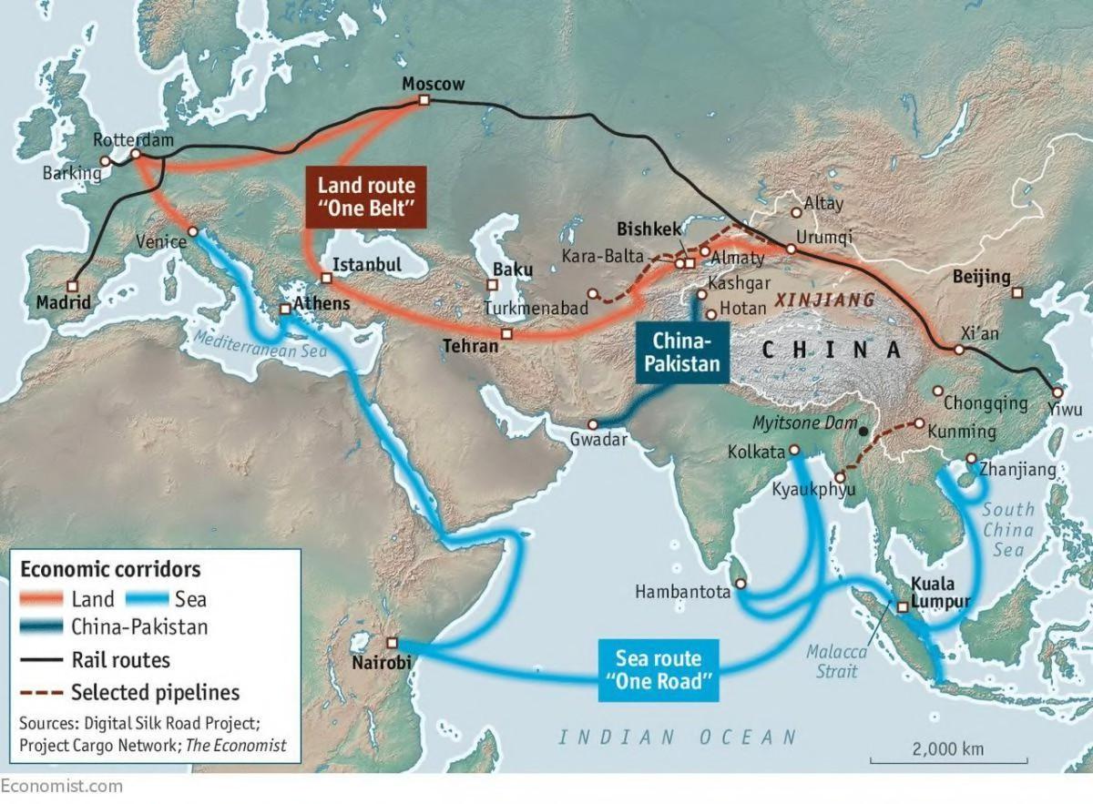 Its geographical logic can be represented as:
Western China
↓
Xinjiang
↓
Pakistan
↓
Gwadar / Arabian Sea
The corridor is sometimes presented as a complete alternative to the Strait of Malacca. A more precise formulation is that such overland infrastructure can diversify China’s connectivity options, although it cannot simply replace maritime trade at the scale of China’s overall economy.
Diversification of Routes ≠ Elimination of Maritime Dependence
8.5 Institutional Dimension: SCO
Infrastructure is accompanied by institutional engagement. The Shanghai Cooperation Organisation (SCO) provides a regional framework involving China, Russia and Central Asian states, with cooperation extending across security, transport, economic and diplomatic domains. Thus:
Infrastructure + Institutions + Trade + Energy create a broader form of network power. The important correction here is that the SCO does not currently operate an “SCO Bank” comparable to the Asian Development Bank or World Bank. It is therefore better to use SCO institutional cooperation and China-led financing mechanisms rather than presenting an established SCO Bank as a current fact.
8.6 Western Counter-Moves
China’s growing Eurasian and maritime connectivity has encouraged other states to strengthen their own networks. Important examples include: QUAD 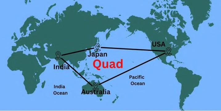 India + United States + Japan + Australia AUKUS
Australia + United Kingdom + United States Indo-Pacific Strategy
Greater emphasis on maritime security, connectivity and regional partnerships. These should not simply be described as a single “anti-China encirclement” because their objectives and institutional structures differ. However, collectively they illustrate the growing importance of Indo-Pacific strategic balancing.
8.7 Multi-Vector Diplomacy in Central Asia
Central Asian states occupy a strategic position between major powers: Russia + China + Europe + Turkey + Iran + United States
Their foreign policies therefore often seek multiple partnerships rather than exclusive alignment. This can be understood as:
Geographical Centrality → Multiple External Interests → Diplomatic Hedging
Such multi-vector diplomacy allows smaller and middle powers to diversify economic, security and diplomatic relationships.
8.8 Modified Heartland: From Territory to Connectivity
The contemporary extension of Mackinder’s framework is therefore not: China = Heartland but rather: China demonstrates how continental power can be strengthened through infrastructure, economic networks and maritime connectivity.
Classical Heartland Territory → Resources → Railways → Continental Power Modified Contemporary Model Territory + Infrastructure + Supply Chains + Technology + Ports → Networked Power
The contemporary applications demonstrate that Mackinder’s central insight survives, but in a modified form. The geopolitical importance of Eurasia still depends heavily on location, strategic depth, resources, corridors and access to maritime space. However, modern power is increasingly produced through connectivity rather than territorial possession alone. This is the key transition from Mackinder’s territorial Heartland to the contemporary geopolitics of corridors, chokepoints, supply chains and networked power.
PYQs
1. Explain the Heartland theory with reference to contemporary geopolitical scenario of the world. (15 Marks/2024)
2. “The Heartland Theory is gaining importance once again.” Comment. (20 Marks/2017)
3. Write short note: relevance of Heartland theory in Contemporary World. (10 Marks/2013)
4. Disuses in detail the Heartland concept of Mackinder and the criticism it has attracted in recent years. (1989)
In case you still have your doubts, contact us on 9773890604
Enrol in Geography Optional by Shabbir Sir: Here
Enrol in One on One Personalized Mentorship: Here
Enrol in GS Mentorship Program: Here
Enrol In GS Mains Mentorship Program: Here
Explore One Integrated Platform for UPSC Prep: Yooki
Visit our YouTube Channel: here