

Contents
- 1 The South Asian Monsoon: General Characteristics and Unique Features
- 2 Theories on the Mechanism of the South Asian Monsoon
- 2.0.1 1. Classical Theories and Their Limitations
- 2.0.2 The Thermal Theory (Hadley’s Theory)
- 2.0.3 The Air Mass Theory (Flohn’s Theory)
- 2.0.4 Modern Theories: Incorporating Upper-Atmospheric Dynamics
- 2.0.5 The Tibetan Heating Theory (Koteswaram’s Theory)
- 2.0.6 The Jet Stream Theory (Yin’s Theory) and the Onset Mechanism
- 2.0.7 The Critical Influence of the Sub-Tropical Westerly Jet (STWJ)
- 2.0.8 The Conflict: Thermal Low vs. Dynamic High
- 2.0.9 The Blocking Effect
- 2.0.10 A Consolidated View of Jet Stream Influence on Indian Monsoons
- 2.0.11 Global Oscillations and Their Impact on Monsoon Variability
- 2.0.12 1. El Niño Southern Oscillation (ENSO)
- 2.0.13 2. Indian Ocean Dipole (IOD)
- 2.0.14 3. Madden-Julian Oscillation (MJO)
- 2.0.15 4. Compounding Factors and Prediction Complexity
- 2.0.16 The Seasonal Cycle in India
- 2.0.17 The Hot, Dry Summers (Mar 15 – Jun 15)
- 3 PYQs
The South Asian Monsoon: General Characteristics and Unique Features
1. Defining the Monsoon Phenomenon
Before delving into the complex mechanisms that drive the Indian monsoon, it is essential to first define the general characteristics of monsoon systems as a global climatic phenomenon. Monsoons are not unique to South Asia but are a feature of several tropical regions around the world.
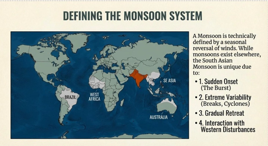
In general terms, monsoons can be defined by the following characteristics:
- A feature of tropical, warm climates.
- Essentially modified trade winds.
- Characterised by a seasonal reversal of winds.
- Linked to alternate wet and dry conditions.
- Associated with climatic extremes such as floods and droughts.
Globally, regions that experience these types of monsoon climates include the coasts of Brazil, Somalia, and the Gulf of Guinea, as well as broader regions such as South Asia, Southeast Asia, and Northern Australia. While these general features apply broadly, the South Asian monsoon possesses several unique attributes that require a more advanced and specific explanation.
2. The Unique Characteristics of the South Asian Monsoon
The South Asian monsoon system exhibits several unique features that distinguish it from the general global pattern, making its mechanism a subject of intense scientific study for decades. These characteristics cannot be explained by simple thermal theories alone. The specific, unique features of the Indian monsoon are:
- Sudden Onset: The beginning of the rainy season is not gradual but is marked by a rapid and abrupt event often referred to as the “burst” of the monsoon.
- Gradual Advance and Retreat: Following the initial onset, the monsoon slowly progresses across the subcontinent over several weeks. Similarly, its withdrawal at the end of the season is a gradual process.
- Associated Weather Systems: The monsoon season is influenced by, and interacts with, other distinct weather phenomena, including Western Disturbances and tropical cyclones.
- High Rainfall Variability: The monsoon is not a continuous period of rain. It is characterised by significant fluctuations in rainfall intensity and duration, including extended dry periods known as “monsoon breaks.”
Any comprehensive theory of the Indian monsoon must be able to account for not only the general characteristics of wind reversal but also these specific and unique features that define its behaviour over the subcontinent.
Theories on the Mechanism of the South Asian Monsoon
1. Classical Theories and Their Limitations
The scientific understanding of the monsoon has evolved significantly over time. The earliest theories were based on observable, surface-level phenomena, providing an intuitive but ultimately incomplete picture of the complex atmospheric processes at play.
The Thermal Theory (Hadley’s Theory)
This classical theory posits that monsoons are simply a regional-scale manifestation of a land and sea breeze, driven by the differential heating of land and sea across seasons.
- The seasonal parallel is direct:
Summer is analogous to daytime, where the hot landmass develops a low-pressure area, drawing in moist, cooler winds from the sea (onshore winds).
Winter is analogous to nighttime, where the land cools faster than the sea, creating a high-pressure area that causes winds to flow from the cool land towards the warmer sea (offshore winds).
While this theory correctly identifies the fundamental principle of seasonal wind reversal, it is now considered too trivial and simplistic. It correctly identifies the outcome (wind reversal) but fails to explain the complex underlying causes, much like stating an accident was caused by a car hitting a bicycle without analysing the dynamics of speed, road rules, or driver action. Its primary limitation is its failure to explain the defining characteristics of the monsoon. It cannot answer fundamental questions such as why the phenomenon is confined to the tropics and linked to trade winds, nor can it account for the unique features of the Indian monsoon like its sudden onset, gradual retreat, or high variability.
The Air Mass Theory (Flohn’s Theory)
A more sophisticated classical explanation is the Air Mass Theory, which connects the monsoon to global atmospheric circulation patterns. The core mechanism of this theory is the seasonal migration of the Inter-Tropical Convergence Zone (ITCZ)—the low-pressure belt where the trade winds converge—as it follows the apparent movement of the sun.
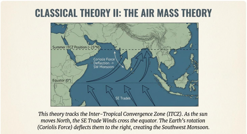
Summer Monsoon: As the sun moves into the Northern Hemisphere, the ITCZ shifts far north, positioning itself over the Indian subcontinent near the Himalayan foothills. To reach this low-pressure zone, the Southeast Trade Winds from the Southern Hemisphere must cross the equator. Upon crossing, they are deflected to the right by the Coriolis force and approach the subcontinent as the Southwest Monsoon winds.
Winter Monsoon: When the sun shifts into the Southern Hemisphere, the ITCZ moves south of the equator. This allows the dominant Northeast Trade Winds to re-establish themselves over India, creating the dry winter monsoon. This theory represents a significant improvement over the simple thermal concept, as it correctly explains the monsoon’s tropical nature and its direct link to the global trade wind system. However, it still cannot explain the unique features of the Indian monsoon, such as the sudden burst, the influence of Western Disturbances, or the occurrence of monsoon breaks. The inadequacies of these classical theories necessitated the development of modern models that incorporate upper-atmospheric dynamics and topographical influences.
Modern Theories: Incorporating Upper-Atmospheric Dynamics
The modern understanding of the monsoon views it as a complex, three-dimensional system. It is driven not just by surface heating but by an intricate interplay of ocean thermal conditions, the role of highlands like the Tibetan Plateau, and, critically, the behaviour of powerful, high-altitude wind patterns known as jet streams.
The Tibetan Heating Theory (Koteswaram’s Theory)
This theory identifies the primary “heat engine” driving the powerful summer monsoon. The central argument is that the intense and sustained heating of the vast and high-altitude Tibetan Plateau is a far more powerful and consistent driver than the heating of the Indian subcontinent’s plains alone.
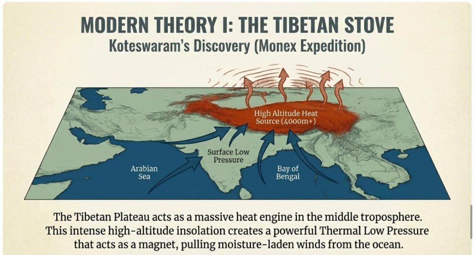
This intense heating occurs because the plateau’s high elevation means the atmosphere is rarefied, with less moisture, dust, and pollutants to reflect or absorb incoming solar radiation, allowing for exceptionally strong surface heating during summer.
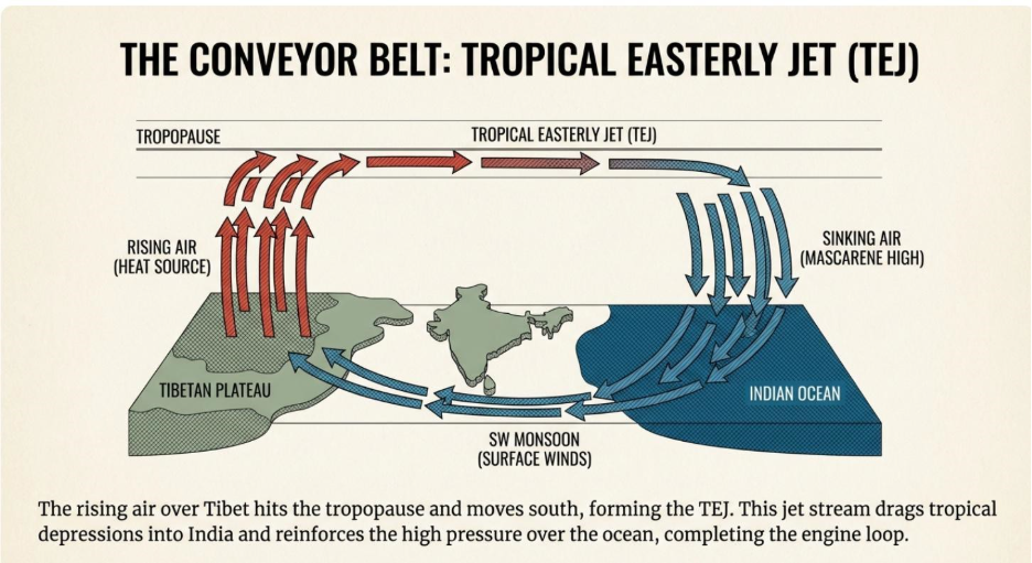
- Role of the Tropical Easterly Jet Stream (TEJ): The immense volume of air rising over the hot Tibetan Plateau diverges in the upper troposphere. This outflow organizes into a high-speed, high-altitude river of air known as the Tropical Easterly Jet Stream (TEJ), which flows from east to west over Peninsular India.
- Impact of the TEJ: The strength of the TEJ has a positive correlation with the strength of the monsoon. Specifically, the TEJ helps to “steer” or “drag” tropical depressions (low-pressure systems) that form over the Bay of Bengal westward across the Indian mainland. These depressions are responsible for a significant portion of the monsoon’s rainfall.
The Jet Stream Theory (Yin’s Theory) and the Onset Mechanism
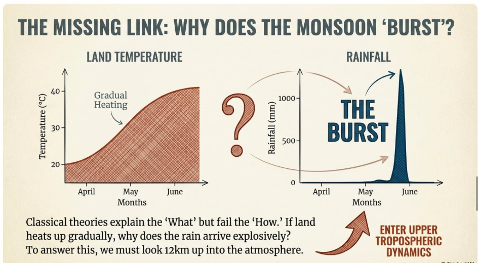
This theory provides a crucial explanation for one of the monsoon’s most unique features: its sudden onset. The mechanism is linked to the seasonal behaviour of another major jet stream, the Subtropical Westerly Jet Stream (STWJ).
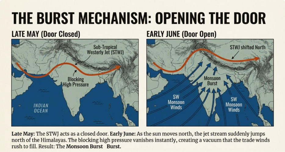
- The “Blocking” Mechanism: In the months preceding the monsoon, the powerful STWJ, flowing from west to east, is bifurcated by the massive obstacle of the Himalayas and the Tibetan Plateau. This split creates a strong southern branch that flows over the northern plains of India. This high-altitude southern branch induces a dynamic high-pressure system on the surface below it. This high pressure effectively counteracts the thermal low pressure building over the heating subcontinent, blocking the moisture-laden southwest winds from advancing into India. The monsoon winds essentially stall off the coast, unable to proceed inland.
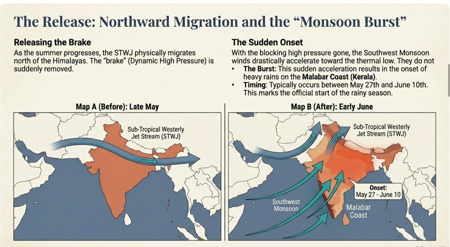
- The “Sudden Onset”: The “burst” of the monsoon is triggered in late May or early June. As the sun’s apparent position shifts further north, the entire STWJ system is forced to migrate north of the Himalayas. The abrupt disappearance of its southern “blocking” branch causes the surface high pressure to collapse. This allows the powerful, pre-existing Tibetan low-pressure system to suddenly and forcefully pull the waiting, moisture-rich monsoon winds onto the subcontinent, resulting in the dramatic onset of the rainy season.
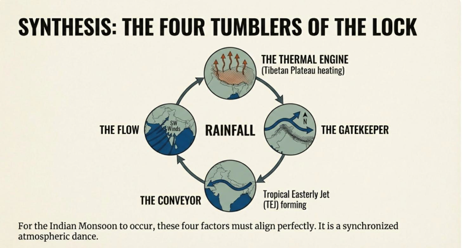
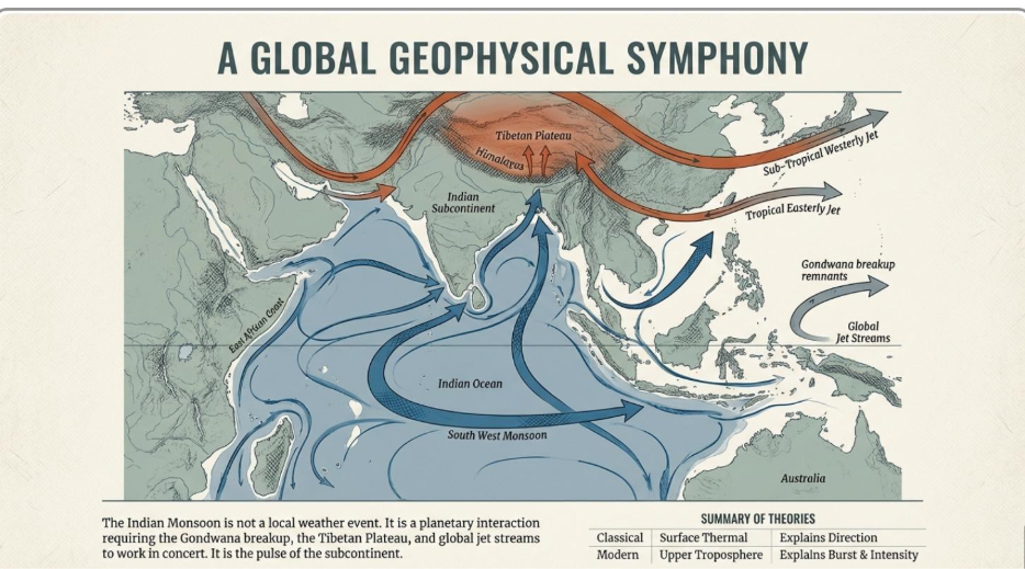
In summary, the modern view recognises the South Asian monsoon as a deeply complex phenomenon, governed by a dynamic interplay between surface thermodynamics (land/sea heating), the unique high-altitude topography of the Tibetan Plateau, and the powerful, controlling influence of upper-atmospheric jet streams.
The Critical Influence of the Sub-Tropical Westerly Jet (STWJ)
The Sub-Tropical Westerly Jet (STWJ) is a year-round, high-altitude wind that flows from west to east. Its interaction with the Himalayas and the Tibetan Plateau has a multifaceted and decisive impact on India’s weather patterns, controlling key phases of the monsoon cycle.
The Conflict: Thermal Low vs. Dynamic High
During early summer, the land heats up, creating a Thermal Low. Ideally, this should pull in monsoon winds. However, the monsoon is delayed. Why?
The Blocking Effect
The Sub-Tropical Westerly Jet (STWJ) is bifurcated by the Himalayas. Its Southern Branch flows directly over the Northern Plains. This jet induces sinking air, creating a dynamic high-pressure system that sits on top of the surface heat.
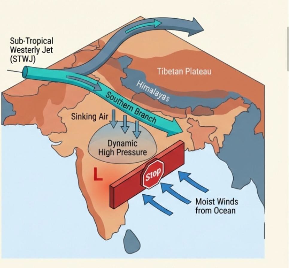
Blocking the Monsoon During the winter and spring, the STWJ is bifurcated by the Himalayan-Tibetan massif into a northern and a southern arm. The southern arm flows south of the Himalayas, over the northern Indian plains. This upper-atmospheric flow induces a “dynamic high pressure” at the surface. This high-pressure system is strong enough to counteract the thermal low-pressure that begins to form over the heating landmass, effectively blocking the Southwest Monsoon winds from entering India.
Triggering the Monsoon Burst As summer intensifies, the STWJ gradually migrates northwards with the shifting of the global pressure belts. The critical event is when the southern arm moves far enough north to clear the Himalayas and merge with the northern arm. This northward shift removes the high-pressure block over the northern plains almost instantaneously. With the barrier gone, the warm, moist Southwest Monsoon winds—which have been accumulating over the Arabian Sea—are free to accelerate suddenly and surge into the subcontinent. This phenomenon is the “Monsoon Burst” or “sudden onset,” which typically makes its first appearance along the Malabar Coast of Kerala.
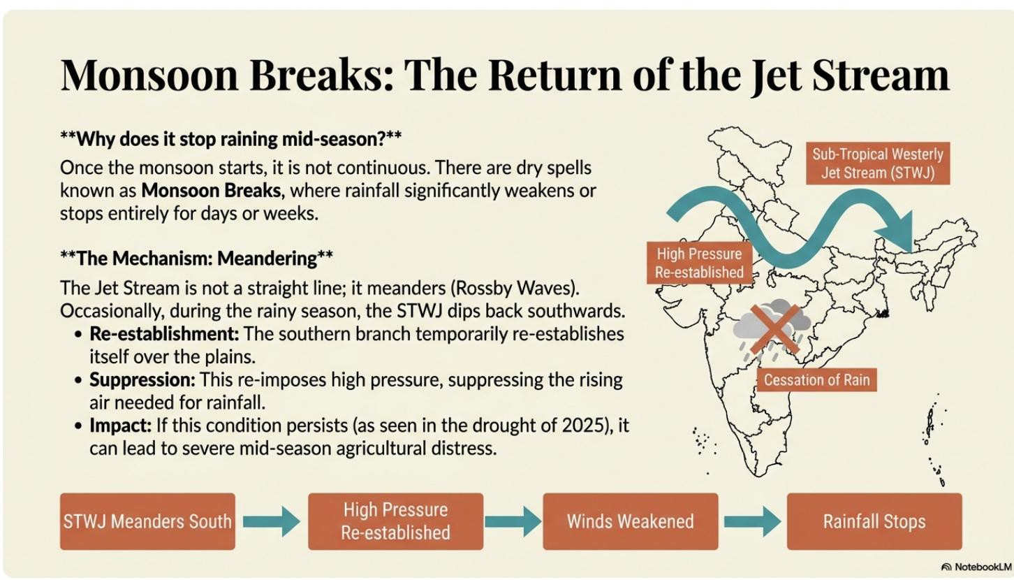
Causing Monsoon Breaks: Even after the monsoon is established, the STWJ can continue to influence rainfall. The jet stream naturally has a meandering, wave-like path. During the rainy season, a significant southward meander can cause its southern branch to temporarily re-establish itself over the northern plains. This reintroduces high pressure, which weakens the monsoon circulation and can cause the rains to lessen or stop altogether for a period. These dry spells are known as “Monsoon Breaks” and, if prolonged, can lead to drought conditions.
Creating Winter Precipitation (Western Disturbances): In the winter, when the STWJ is firmly positioned south of the Himalayas, its flow is intercepted by the Pamir and Himalayan ranges. As it travels from west to east, the jet stream picks up moisture from sources like the Mediterranean Sea and the Persian Gulf. This moisture is then carried towards India, where the interaction with the mountains forces the air to rise, cool, and release precipitation. This results in light winter rains (approximately 6-10 cm) and snowfall in Northwest India (Kashmir, Punjab, Haryana) and parts of Northeast India (Assam, Arunachal Pradesh). This phenomenon is known as “Western Disturbances” and is critically important for the cultivation of winter (rabi) crops like wheat. In summary, the upper-atmospheric jet streams, particularly the STWJ, exert profound and complex control over the entire annual weather cycle in India, from blocking the monsoon’s arrival to triggering its onset and even providing crucial winter precipitation.
A Consolidated View of Jet Stream Influence on Indian Monsoons
A comprehensive understanding of the Indian monsoon requires synthesising the distinct but interconnected roles of multiple jet streams. These high-altitude wind systems elevate the monsoon from a simple surface-level phenomenon to a complex, three-dimensional atmospheric event. The three primary jet streams identified as influencing the Indian monsoon are:
- Tropical Easterly Jet (TEJ): Active during the summer and rainy season, the TEJ is directly linked to the intense heating of the Tibetan Plateau. Its primary function is to steer moisture-laden tropical depressions from the Bay of Bengal over the Indian subcontinent, sustaining rainfall during the monsoon season.
- Sub-Tropical Westerly Jet (STWJ): This is a key player throughout the year. Its position relative to the Himalayas is critical for blocking the monsoon’s entry, triggering the dramatic “monsoon burst,” causing dry spells known as “monsoon breaks,” and delivering vital winter precipitation through “Western Disturbances.”
- Somali Jet Stream: This is an unusual, low-level jet stream, flowing at an altitude of only about 1.6 kilometres. It develops off the coast of Somalia and strengthens the Southwest Monsoon winds as they travel across the Arabian Sea. The strength of the Somali Jet is positively correlated with good rainfall in India, making it an important component of the overall monsoon system.
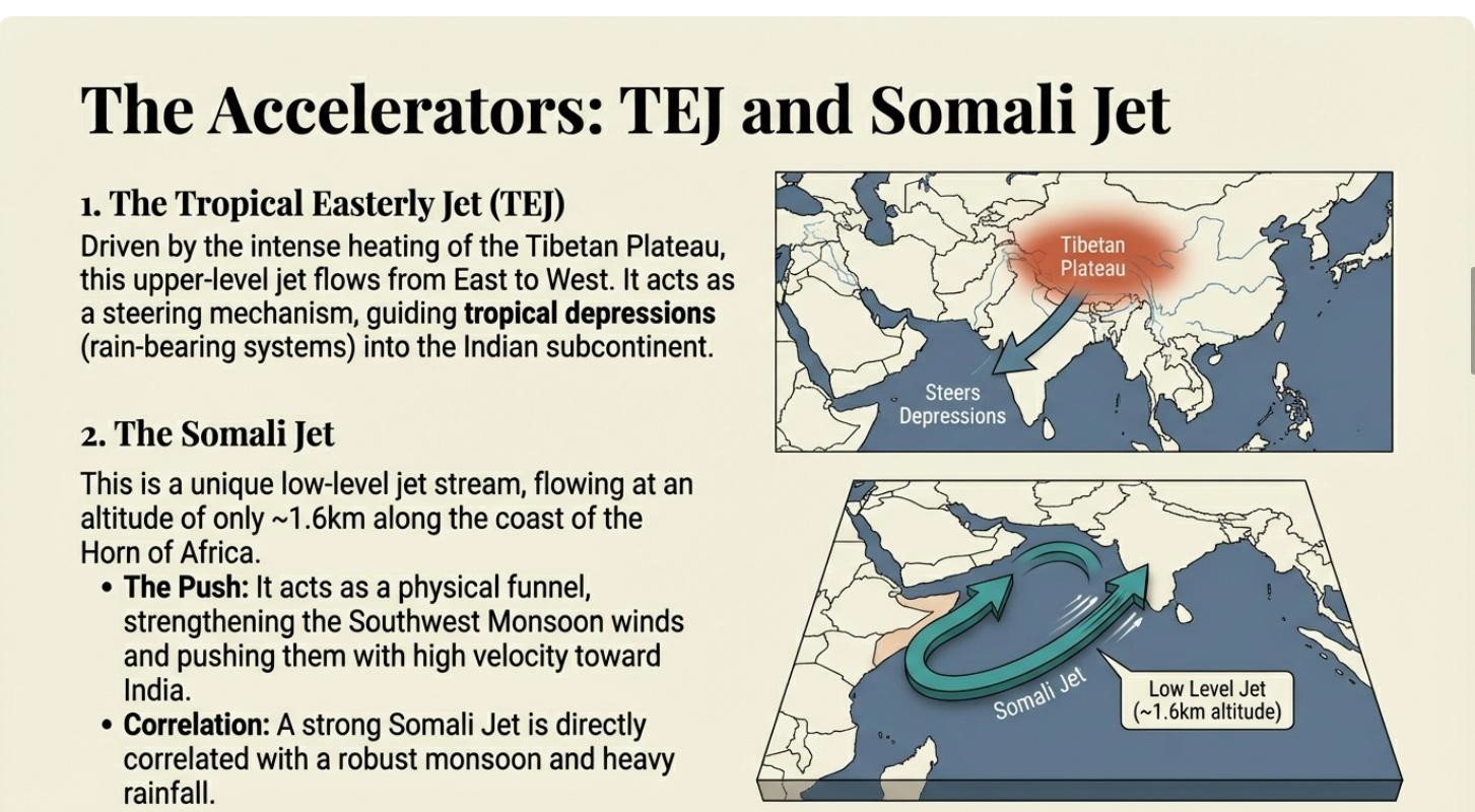
Together, these jet streams demonstrate that the Indian monsoon is not merely a surface wind system. It is a deeply integrated atmospheric phenomenon, intricately linked to upper-tropospheric circulation patterns, which are themselves subject to influence from global-scale oscillations.
Global Oscillations and Their Impact on Monsoon Variability
The Indian monsoon does not operate in isolation. Its year-to-year variability is significantly influenced by larger-scale, periodic shifts in oceanic and atmospheric conditions that occur across the globe. These oscillations can dramatically alter the strength and timing of the monsoon, making prediction an exceptionally complex challenge. This section explores three critical global and regional oscillations.
1. El Niño Southern Oscillation (ENSO)
ENSO is a major climatic driver originating in the tropical Pacific Ocean, with two opposing phases—El Niño and La Niña—that have a strong inverse correlation with Indian monsoon rainfall.
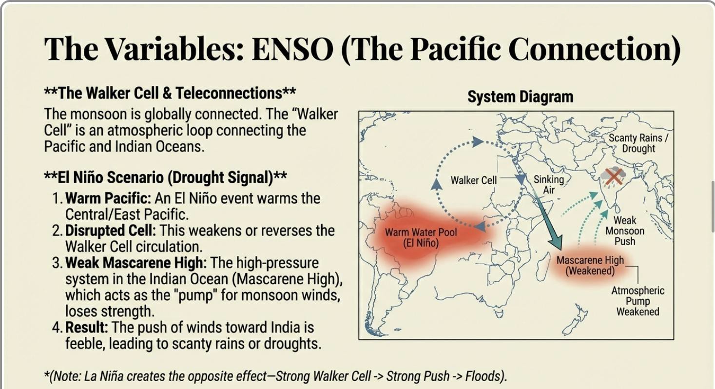
- El Niño Conditions: An El Niño event is characterised by unusually warm sea surface temperatures in the central and eastern Pacific Ocean. This warming weakens the atmospheric circulation pattern known as the Walker Cell. A weaker Walker Cell leads to a weaker Mascarene High-pressure system in the Indian Ocean. Since this high-pressure system is a primary driver pushing the monsoon winds towards India, its weakening results in a weaker monsoon, leading to less rain and a higher probability of droughts.
- La Niña Conditions: A La Niña event is the opposite, characterised by cooler-than-average sea surface temperatures in the Pacific. This strengthens the Walker Cell, which in turn strengthens the Mascarene High. A more powerful Mascarene High creates a stronger push of Southwest Monsoon winds toward India, often resulting in very good rainfall and an increased risk of floods.
2. Indian Ocean Dipole (IOD)
The IOD, sometimes referred to as the “Indian Ocean El Niño,” is a similar phenomenon of oscillating sea surface temperatures that occurs within the Indian Ocean itself. It is defined by the temperature contrast between the western Indian Ocean (Arabian Sea) and the eastern Indian Ocean.
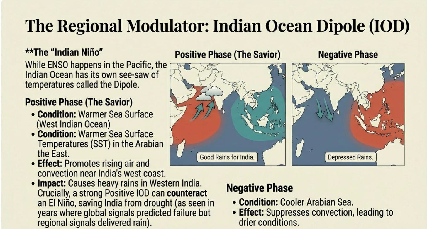
- Positive Phase: This phase is characterised by a warmer-than-average Arabian Sea and cooler waters in the east. The warmer water in the west enhances convection and moisture availability, leading to good rains in Western India.
- Negative Phase: This phase involves a cooler-than-average Arabian Sea and warmer waters in the east. This condition suppresses convection near India, resulting in depressed rains and drier conditions, particularly in Western India.
3. Madden-Julian Oscillation (MJO)
The MJO is a large-scale, eastward-moving system of regional convection that propagates along the equatorial belt. It operates on a shorter timescale than ENSO or IOD, with a periodicity of 30, 60, or 90 days. The MJO has two distinct phases as it passes over a region:
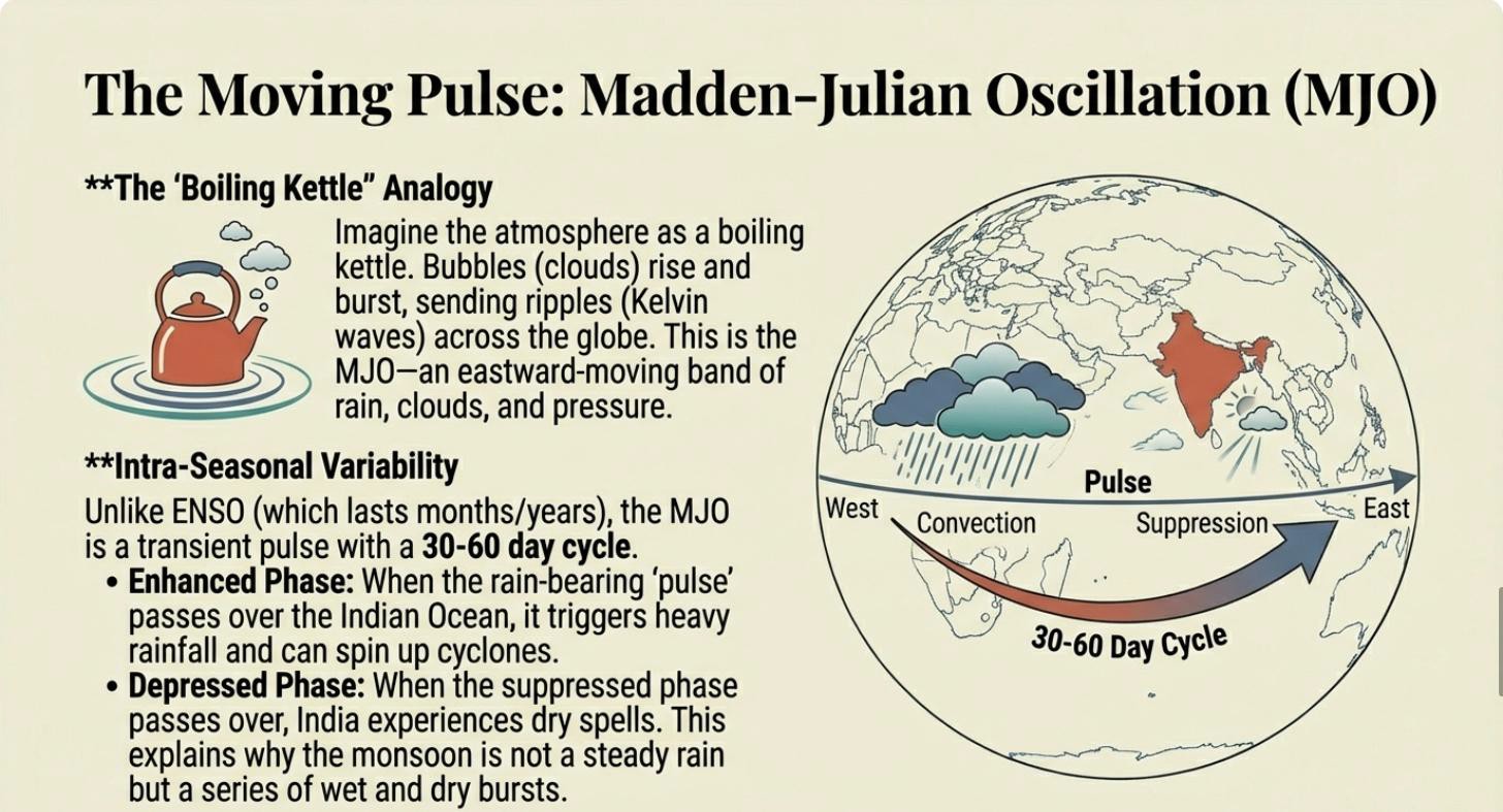
- An enhanced rain phase associated with rising air and increased convection.
- A depressed rain phase associated with sinking air and suppressed convection.
During the Indian summer, this system sometimes migrates northwards and can impact the monsoon. If the MJO’s enhanced phase passes over India, it can cause periods of heavy rain. Conversely, the arrival of its depressed phase can lead to breaks in the monsoon and potential droughts.
4. Compounding Factors and Prediction Complexity
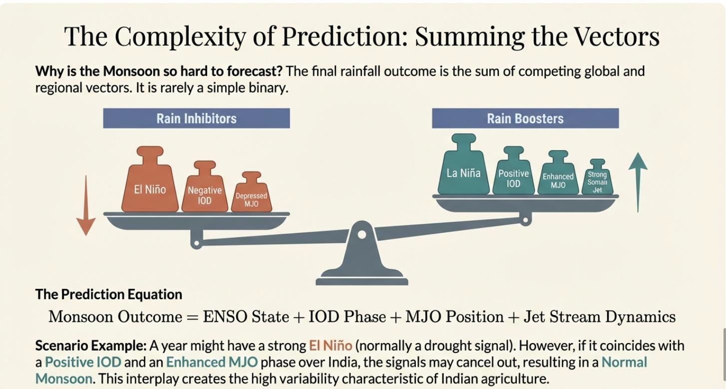
The interplay between ENSO, IOD, and MJO makes monsoon prediction exceptionally difficult. These systems can interact in complex and sometimes counterintuitive ways. For example, a year may be dominated by El Niño conditions, which would typically suggest a drought. However, the negative effects of El Niño can be countered if a positive IOD or an enhanced phase of the MJO occurs simultaneously. This combination can lead to unexpectedly good rains, highlighting the severe challenges in accurately forecasting monsoon performance. These complex interactions are the primary reason for the high degree of rainfall variability and manifest in India’s distinct seasonal weather patterns.
The Seasonal Cycle in India
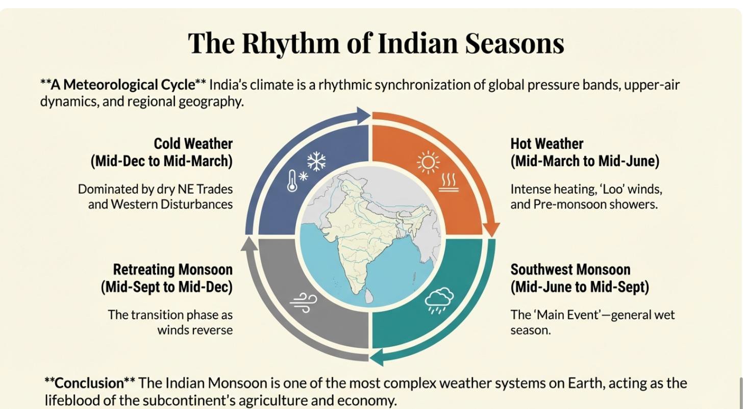
India’s seasons are uniquely defined by the monsoon system rather than by the sharp temperature variations typical of temperate climates. This is due to the moderating influence of the Himalayas, which block cold Central Asian winds, and the vast peninsular coastline, which tempers temperature extremes. As a result, India’s seasonal calendar is more appropriately categorised by monsoon-driven rainfall patterns, dividing the year into four distinct periods.
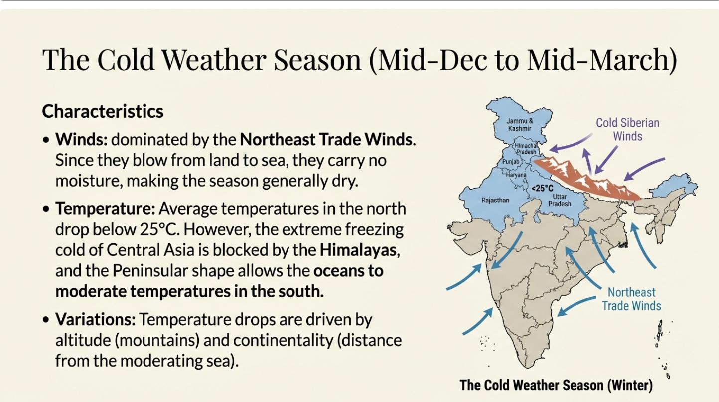
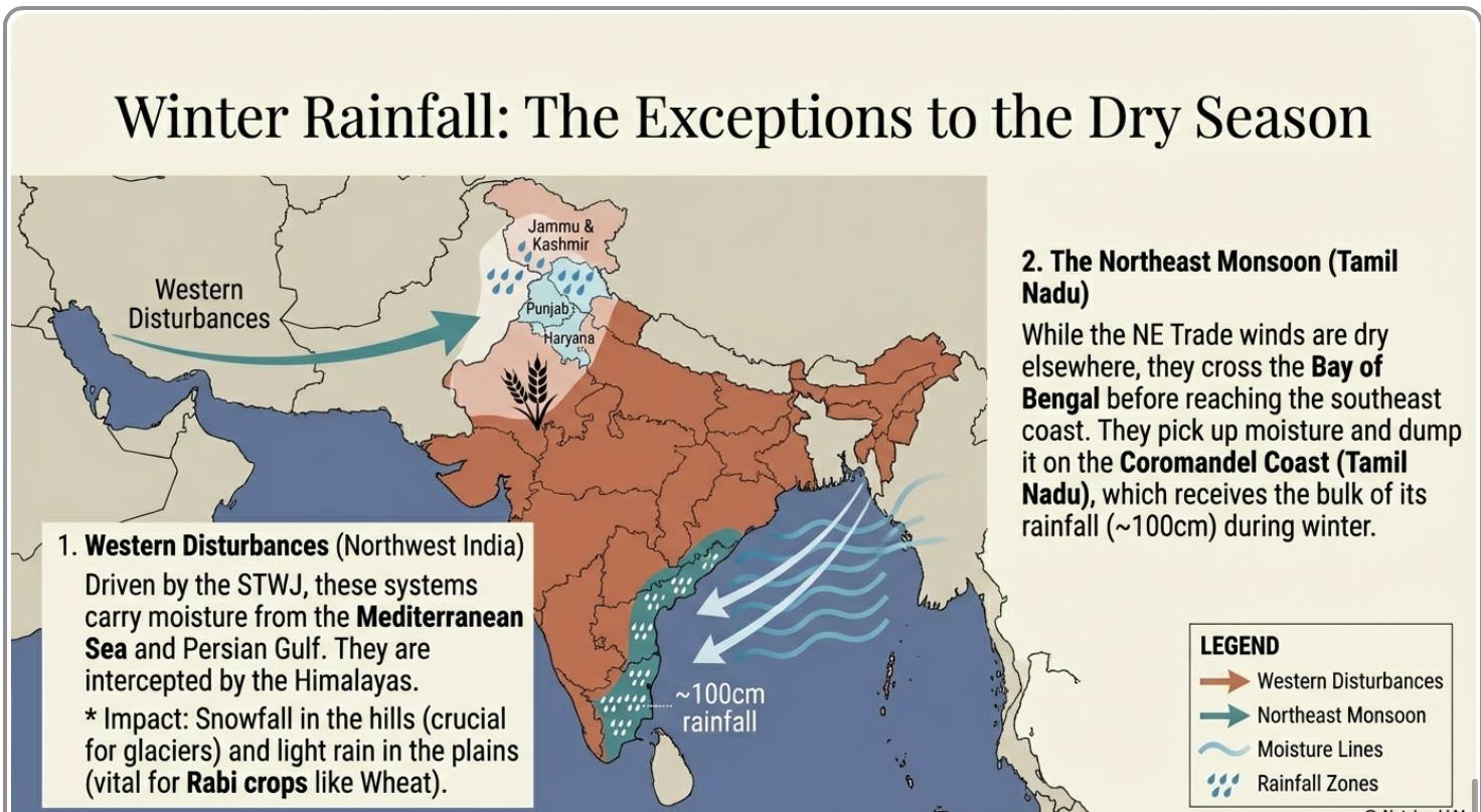
1. The Dry Winters (Northeast Monsoon Season: Dec 15 – Mar 15). This season is generally characterised by cold and dry conditions across most of the country. The prevailing winds are the offshore Northeast Trade Winds, which blow from the land to the sea and carry little moisture. However, three distinct regions receive rainfall during this otherwise dry period:
- Northwest and Northeast India: Precipitation in these regions is caused by Western Disturbances. The Sub-Tropical Westerly Jet (STWJ) carries moisture from the Mediterranean region, which is then intercepted by the Himalayas, causing light rain and snowfall.
- Tamil Nadu / Coromandel Coast: Due to the unique southeastward orientation of this coastline, the Northeast Trade winds, after passing over the Bay of Bengal, become onshore winds. They pick up moisture from the Bay and bring significant winter rainfall to this region, making it the primary rainy season for the Coromandel Coast.
The Hot, Dry Summers (Mar 15 – Jun 15)
This pre-monsoon season is marked by rapidly rising temperatures as the sun moves northwards. The intense heating of the subcontinent, especially the Tibetan Plateau, leads to the development of a strong low-pressure system.
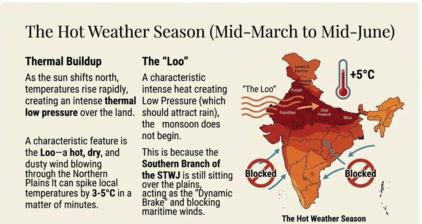
However, the southern branch of the STWJ remains positioned over the northern plains, creating a dynamic high-pressure block that prevents the moist oceanic winds from entering India. Consequently, this season remains predominantly hot and dry. This period is characterised by several local weather phenomena driven by intense surface heating:
- Loo: A hot, dry, and dusty wind that blows across the Northern Plains, causing sharp increases in temperature.
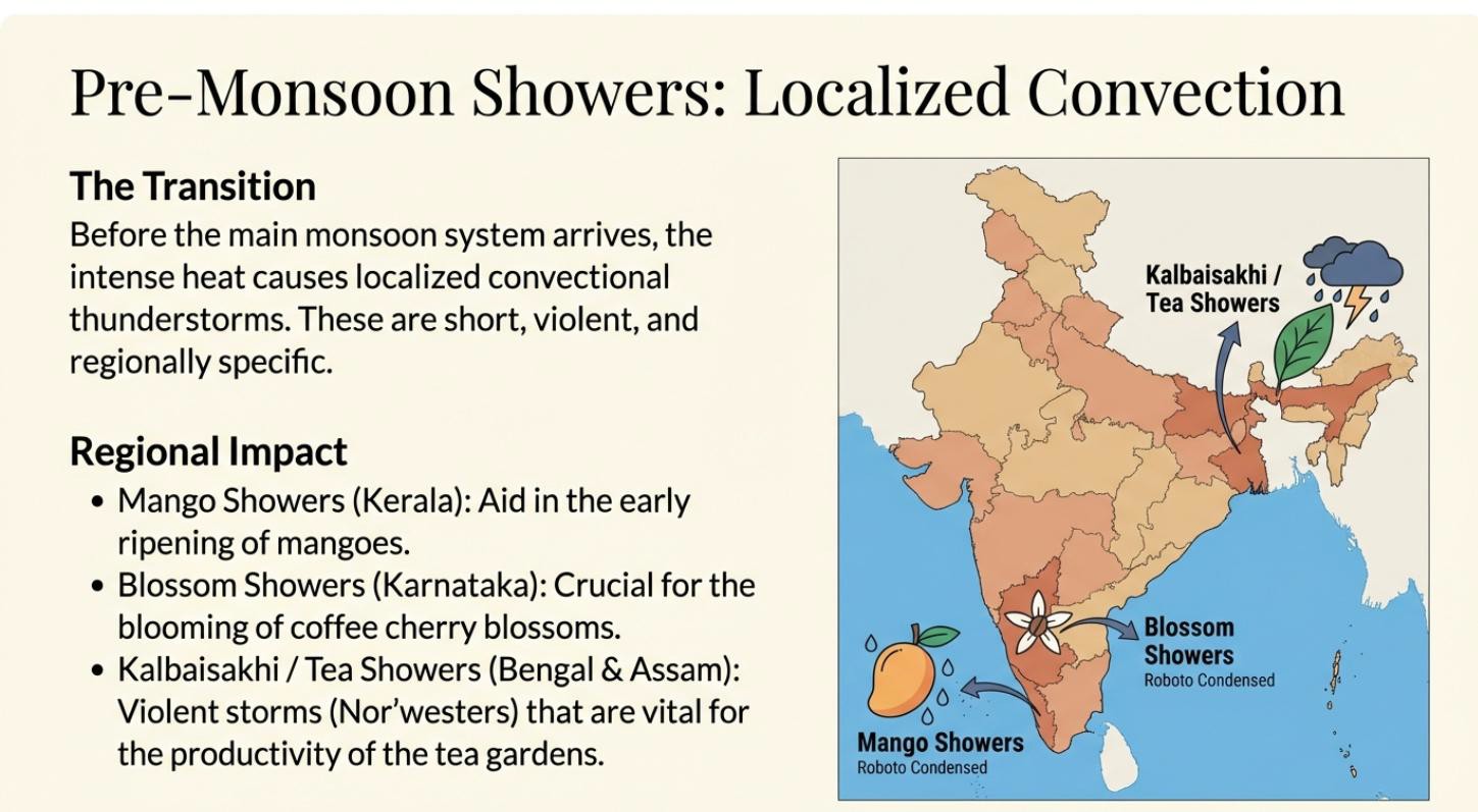
- Pre-Monsoon Thunderstorms: Localised and intense convectional heating can trigger brief but powerful showers, often accompanied by strong winds. These thunderstorms have distinct regional names:
- Kal Baisakhi: Occurring in Bihar and on the plains of Bengal.
- Tea Showers: Benefiting tea cultivation on the hills of Bengal and Assam.
- Blossom Showers: Aiding the blossoming of coffee plants in Karnataka.
- Mango Showers: Helping in the ripening of mangoes in Kerala.
PYQs
1. Critically evaluate the role of primate cities in dominating the urban spheres of influence in developing countries. (15 Marks/2025)
2. Write a short note on primate cities. (2008)
3. In urban geography, what are the concepts of primate city and Rank Size Rule? Discuss in detail. (2006)
4. Write a short note: Concept of primate city. (2005)
5. Write a short note: Primate city. (1999)
6. Short note: Rank- Size Rule. (2000)
7. Discuss the concept of ‘Rank-Size-Rule’ given by G.K. Zipf. Is this rule relevant in the Indian context? (15 Marks/2022)
8. Analyse the measuring patterns of settlement in relation to the nearest Neighbour Index and Rank-Size Rule in detail. (15 Marks/2026)
In case you still have doubts, contact us at 9773890604
Enrol in Geography Optional by Shabbir Sir: Here
Enrol in One-on-One Personalised Mentorship: Here
Enrol in GS Mentorship Program: Here
Enrol In GS Mains Mentorship Program: Here
Explore One Integrated Platform for UPSC Prep: Yooki
Visit our YouTube Channel: Here