Explore the process of delineating formal regions by proposing criteria, indicators, and methodologies, as outlined in the UPSC Geography Optional Mains exam for 2021. Delve into the considerations for defining boundaries based on geographical, socio-economic, and cultural characteristics. Examine the various indicators used to identify and classify formal regions, including demographic data, land use patterns, and administrative divisions. Discuss techniques such as GIS mapping, statistical analysis, and field surveys employed in the delimitation process. Gain insights into the challenges and opportunities associated with establishing clear and meaningful boundaries for formal regions, crucial for effective regional planning and governance. This examination offers a comprehensive understanding of the methodologies involved in delineating formal regions, essential for geographic analysis and policy formulation.
Contents
Answer:
A formal region is a geographic area characterized by specific, well-defined criteria, and distinct features that set it apart from neighboring areas. Delimitation of formal regions involves grouping local units with similar characteristics based on clearly defined criteria.
Criteria for Delimitation of Formal Regions:
- Geographic Boundaries: Utilize natural features like rivers or mountains to define the boundaries of a formal region.
- Cultural Homogeneity: Group regions based on shared cultural characteristics such as language, religion, and customs.
- Economic Activities: Delineate regions based on predominant economic activities, be it agricultural, industrial, or commercial.
- Population Density: Consider regions with similar population concentrations for delineation.
- Political Boundaries: Use administrative divisions like states or provinces as criteria for delimitation.
Indicators for Delimitation of Formal Regions:
- Unemployment Rates: Consider regions with similar unemployment rates for delineation.
- Activity Rate: Evaluate regions based on levels of economic activity.
- Migration Trends: Analyze patterns of migration as indicators for grouping regions.
- Per Capita Income: Consider income levels as a factor for delineation.
- Land Use Patterns: Examine how land is used for residential, commercial, industrial, or agricultural purposes.
Techniques for Delimitation of Formal Regions:
- Weighted Index Number Methods:
● Mono Variate Method: Focus on a single variable like unemployment rates or per capita income,
assigning weights for delineation.
● Fixed Index Method: Choose a common characteristic feature, assign weights, and calculate
mean values.
● Variable Index Method: Use variable weights to highlight different activity levels in various
regions.
● Cluster Method: Employ mapping techniques to identify homogeneous regions based on
weighted indices.
Example :
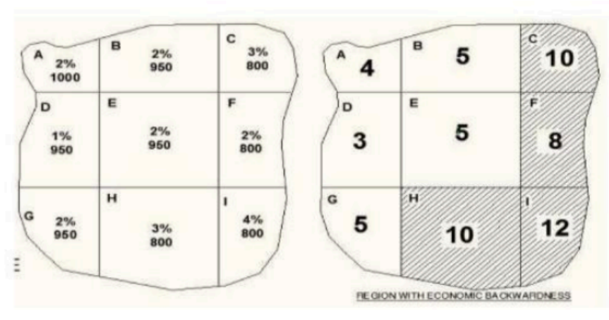
To carve out a region of economic backwardness the parameters chosen were % of unemployment and Per capita income. Then accordingly the weights were set up. It was decided that for every 1% of unemployment 2 weights shall be assigned and setting 1000 as the base for every 50 points below 1000, 1 weight shall be assigned. Hence more is the total weight more is the backwardness.
Suppose we consider a hypothetical area divided into 9 blocks having the given unemployment percentages and per capita income. If we then apply weights to each block as stated in the previous paragraph, we will find that we can hatch an area with relatively more economic backwardness. Hence,After the weights we could find that the area HIFC forms the area of economic backwardness.

- Factor Analysis Methods:
● Map each parameter separately, overlay the maps, and identify common regions based on factor loadings.
Example:
To carve out the South Eastern Mineral Region. The parameters considered were geology, minerals (coal, iron ore, bauxite, silica), availability of rail, soil, vegetation, climate, and population. Each line depicts an aspect and is called a girdle.
The area which satisfied 6 girdles was carved out and was called the SE resonce region. Sometimes some parts of the delineated area have administrative conflicts at those moments, adjustment is done on the basis of smallest unit of delineation method.

Conclusion:
In the future, the delimitation of formal regions will likely benefit from advancements in data analytics and technology. Integrating real-time data and artificial intelligence could enhance the accuracy of delineation methods. Moreover, collaborative efforts between geographers, economists, and technology experts can contribute to refining existing criteria and techniques for more precise regional delineation.
In case you still have your doubts, contact us on 9811333901.
For UPSC Prelims Resources, Click here
For Daily Updates and Study Material:
Join our Telegram Channel – Edukemy for IAS
- 1. Learn through Videos – here
- 2. Be Exam Ready by Practicing Daily MCQs – here
- 3. Daily Newsletter – Get all your Current Affairs Covered – here
- 4. Mains Answer Writing Practice – here

