
Explore comprehensive UPSC Geography Optional Mains Topic Wise Questions focusing on World Maps. This curated collection delves into the intricacies of global geography, offering a structured approach to prepare for the UPSC mains examination. Each question is meticulously crafted to enhance understanding and proficiency in map-based concepts, ensuring thorough coverage of the syllabus. From geographical features to spatial relationships, candidates gain valuable insights into diverse regions, fostering a holistic grasp of world geography. Elevate your preparation with targeted inquiries designed to sharpen analytical skills and deepen comprehension. Accessible and organized, this resource serves as an invaluable aid for aspirants navigating the complexities of geography in the UPSC examination.
Contents
- 1 Q1. On the world map provided, mark the following and write in not more than ten words in your answer-book what you consider to be the most significant aspect of each one of them: (1994)
- 2 Q2. On the world map provided mark the following and write in not more than ten words in your answer book what you consider to be the most significant aspect of each one of them: (1993)
- 3 Q3. On the outline map of the world supplied to you, mark any ten of the following and also write in your answer script the most significant aspect of every one of them in not more than ten words each: (2004)
- 4 Q4. On the outline map of the world supplied to you mark any ten of the following and also write in your answer script the most significant aspect of each of them in not more than ten words. (2003)
- 5 Q5. On the outline map of the world supplied to you mark any ten of the following and also write in your answer script the most significant aspect of everyone of them in not more than ten words each. (2002)
- 6 Q6. On the outline map of the world supplied to you mark any ten of the following and also write in your answer script the most significant aspect of each of them in not more than ten words : (2001)
- 7 Q7. On the supplied outline map of the world mark any TEN of the following and also write in your answer sheet the most significant aspect of each of them in not more than TEN words. (2000)
- 8 Q8. On the outline map of the world provided, mark the following and also write in your answer-book in not more than ten words, what you consider to be the most significant aspect of each of them: (1999)
- 9 Q9. On the world map provided, mark the following and write in not more than ten words in your answer book, what you consider to be the most significant aspect of each one of them: (1998)
- 10 Q10. On the world map provided, mark the following and write in not more than ten words in your answer-book what you consider to be the most significant aspect of each one of them: (1997)
- 11 Q11. On the world map provided, mark the following and write in not more than ten words in your answer-book what you consider to be the most significant aspect of each one of them: (1996)
- 12 Q12. On the world map provided, mark the following and write in not more than ten words in your answer-book what you consider to be the most significant aspect of each one of them: (1995)
- 13 In case you still have your doubts, contact us on 9811333901.
Q1. On the world map provided, mark the following and write in not more than ten words in your answer-book what you consider to be the most significant aspect of each one of them: (1994)
A. White Sea
B. Zambezi River
C. Tienshan Range
D. Hawaiian Islands
E. Abidjan
F. Windhoek
G. Canberra
H. Areas of Mediterranean type of climate in Australia
I. Lake Balkhash
J. Pyongyang
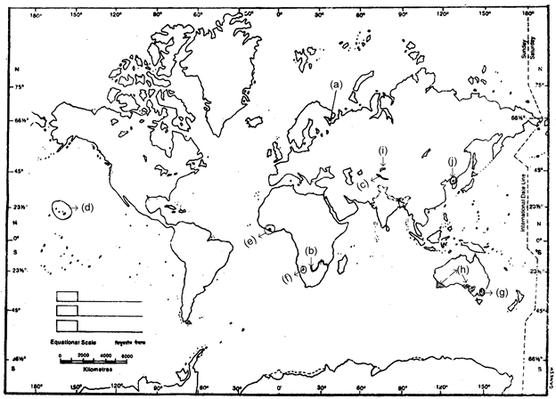
Answer:
A. White Sea: A sea situated in the subpolar region of extreme North-Western Russia, Ice-breakers keep the frozen sea open, an important trade route of Russia.
B. Zambezi River: A river in Africa mainly through Zambia, Zimbabwe and Mozambique, famous for Victoria falls and Kariba dam on it.
C. Tien Shan Range: A mountain range in central Asia and Western China, contains rich deposits of coal, rock salt, metals etc.
D. Hawaiian Islands: Pacific state of United States of America, of volcanic origin, known as orchid islands of the world, famous for tourism.
E. Abidjan: It is the capital and chief port city of Ivory coast in Africa.
F. Windhoek: It is the capital and most important city of Namibia, an African country.
G. Canberra: It is the capital and only important city of Australia not situated in the coastal region.
H. Area of Mediterranean type of climate Australia: Mediterranean climate characterised by winter rainfall is experienced in South-Western and South-Eastern parts of Australia.
I. Lake Balkhas: Crescent shaped lake in S.E. Kazakhastan, important for copper deposits in the northern shore.
J. Pyongyang: It is the capital of North Korea and one of the most important industrial centres.
Q2. On the world map provided mark the following and write in not more than ten words in your answer book what you consider to be the most significant aspect of each one of them: (1993)
A. Great Dividing Range
B. Cyprus
C. Yellow Sea
D. Rub-al-Khali
E. Selvas
F. Agulhas Current
G. Laurentian Plateau
H. Str. of Gibralter
I. Rhine River
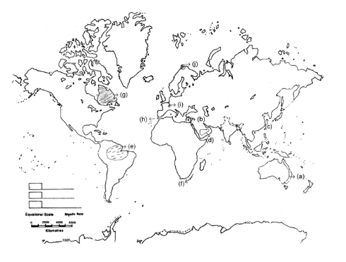
Answer:
A. Great Dividing Range: A worn down old fold mountain extending all along the eastern coast of Australia. Its peak is Mt. Kosciousco.
B. Cyprus: An island nation situated in Mediterranean Sea, known for conflict between Turkish and Greek Cypriots.
C. Yellow Sea: Part of Pacific Ocean situated between Chinese coast and Korean Peninsula, yellow colour due to loes deposits of Hwang-ho river draining into it.
D. Rub-al-Khali: Hot desert Rub-al-Khali meaning ’empty quarters’ is situated in southern part of Saudi Arabia, known for oil reserves.
E. Selves: Equatorial Rainforest situated in Amazon basin is known as Selvas, largest region of hardwood concentration.
F. Agulhas: A warm ocean current flowing along the eastern coast of South Africa.
G. Laurentian Plateau: Vast area of ancient precambrian rocks in Canada (Canadian Shield), well watered with lakes and rich in minerals.
H. Str. of Gibralter: Connects Mediterranean sea to Atlantic Ocean known as key to mediterranean, strategically important, controlled by United Kingdom.
I. Rhine River: Flows through the highly industralized belt of Germany in a rift valley and drains into North Sea, main waterway of Europe.
J. Hammerfest: It is an important fishing centre situated in the north of Norway.
Q3. On the outline map of the world supplied to you, mark any ten of the following and also write in your answer script the most significant aspect of every one of them in not more than ten words each: (2004)
a. Andes
b. Bamian
c. Cape Horn
d. Darwin
e. Fiji
f. Great Lakes
g. Iberian Peninsula
h. Maastricht
i. Nunavut
j. Pyrenees
k. Sinai
l. Kalahari
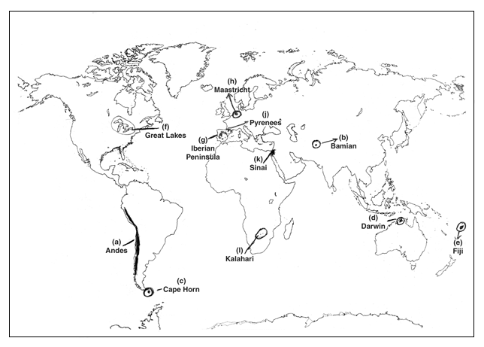
Answer:
(a) Andes: A cordillera-type fold mountain system extending all along the western edge of South America.
(b) Bamian: An ancient historical city of Afghanistan which came in news for the destruction caused to famous rock-statue of Budha by the then Taliban Government.
(c) Cape Horn: Much indented southernmost tip of South America part of Chile.
(d) Darwin: An important port and meteorological station in Australia, capital of Northern Territory.
(e) Fiji: An island-nation in the Pacific Ocean where there has been tussle for power between natives and settled Indians.
(f) Great Lakes: A group of five lakes in North America, very important economically providing facility of indland waterways.
(g) Iberian Peninsula: Situated in south-western part of Europe; surrounded by Bay of Biscay-Atlantic and Mediterranean sea; Spain and Portugal are situated on this peninsula.
(h)Maastricht: An important town of Netherland where a treaty for the formation of European Union was signed.
(i) Nunavut: Part of the Canadian Confederation, came into existence on April 1, 1999. Largest aborigional land claim settlement in Canadian history.
(j) Pyrenees: Young fold mountains of Alpine system, form barrier and border between Spain and France.
(k) Sinai: Previously in Israel’s occupation, now a part of Egypt in Africa, surrounded by Gulf of Suez, Red Sea and Gulf of Aquaba.
(l) Kalahari: A tropical inland desert in Botswana, Africa, Aborigines Bushmen live here.
Q4. On the outline map of the world supplied to you mark any ten of the following and also write in your answer script the most significant aspect of each of them in not more than ten words. (2003)
a. Stewart Island
b. Shibeli River
c. Asuncion
d. Catskill mountains
e. North Cape
f. Cape York Peninsula
g. Tsugaru Strait
h. Izmit
i. Bay of Plenty
j. Gulf of Darien
k. Uranium city
l. Zagreb
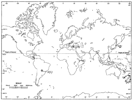
Answer:
(a)Stewart Island: Located in the South Pacific, a part of New Zealand, separated from its South Island by Foveaux strait.
(b) Shibeli River: Originates from Ethiopian Highland, after crossing Somalia drains in Indian Ocean, Mogadishu is located on it.
(c) Asuncion: Capital of Paraguay & its main administrative city, located on the confluence of Pilcomayo & Paraguay rivers.
(d) Catskill Mountain: It is a part of Appalachian Highlands, very close to New York city and at present famous for tourism.
(e) North Cape: The northern most point of the North Island of New Zealand.
(f) Cape York Peninsula: A part of Australia, famous for Bauxite reserves, bounded on three sides by gulf of Carpantria, Arafura sea and Coral sea.
(g) Tsugaru Strait: Joins sea of Japan to Pacific Ocean, separates Hokaido and Honshu Islands of Japan.
(h) Izmit: One of the major ports and industrial cities of Turkey.
(i) Bay of Plenty: A marginal sea of South Pacific Ocean located to the North-East of North Island of New Zealand.
(j) Gulf of Darien: A part of the Caribbean sea, located between Panama and Colombia.
(k) Uranium City: Located on the northern bank of Lake Athabaska in Canada, noted for huge Uranium reserves.
(l) Zagreb: Capital of Croatia and the chief administrative city.
Q5. On the outline map of the world supplied to you mark any ten of the following and also write in your answer script the most significant aspect of everyone of them in not more than ten words each. (2002)
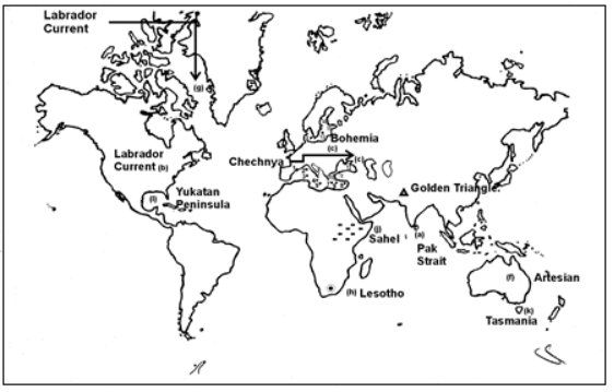
Answer:
(a) Adam’s Bridge: It connects India and Srilanka, represents an ancient suboceanic geological interlink between India and the Srilankan island.
(b) Appalachian Mountains: Located in USA, formed in Caledonian/Hercynian Era, famous for coal.
(c) Bohemia : Ancient Block pleteau lies in Germany.
(d) Chechanya: Part of Russia, where secessionist movement is going in this oil producing region.
(e) Golden Triangle: The opium trading area between Afganistan, Pakistan and Iran.
(f)Great Artesian Basin: It lies in Australia, where aquifer is found at the surface.
(g)Labrador current: Cold current between Greenland and Canada.
(h)Lesotho: A small independent country within South Africa.
(i) Patagonin: Desert plateau of South America developed due to rain shadow effect of And ese.
(j)Sahel: It occupies the horn of East Africa & Tanjania.
(k)Tasmania: Small Island of Australia.
(l)Yukatan Peninsula: It lies in central America, famous for minerals.
Q6. On the outline map of the world supplied to you mark any ten of the following and also write in your answer script the most significant aspect of each of them in not more than ten words : (2001)
a. Bandung
b. Alice Springs
c. Mekong River
d. Gulf of Oman
f. Timor Island
g. Kara Sea
h. Atlas Mountains
i. Gulf of Bothia
j. Agulhas Current
k. Mariana Trench
l. Shiraz
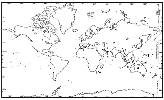
Answer:
- Bandung : It is an important city of Jawa Island in Indonesia, famous for small scale industries. It is the world famous exporter of Cincona.
- Alice Springs : Situating in the southern part of Northern Territories of Australia, it is connected with Adelade through railways. This area has a rich reservoir of natural oil and gas.
- Mekong River : It is the largest river of south-east Asia, which originates in the Tibetan Plateau and after crossing China, Thailand, Laos, Cambodia and Vietnam drains into China Sea. It’s valley is famous for rice cultivation.
- Gulf of Oman : Situating between Iraq and Oman, it is a part of Indian Ocean, famous for natural oil and gas reserve.
- Timor Island : It is a chain of islands in Pacific Ocean. Some time ago, it got independence from Indonesia.
- Kara Sea : It is a part of Arctic Sea whose salinity is very low. It is completely frozen in winter.
- Atlas Mountains : It is a fold mountain situated in north-western Africa. It is branched off in many parts like Sahara Atlas, Sea Atlas, Anti Atlas, etc.
- Gulf of Bothia : Situating between Sweden and Finland, it is a part of Baltic Sea and its salinity is low.
- Agulhas Current : It is a warm ocean current of Indian Ocean, near S. African coast. It is the combination of Malagasy and Mozambique current.
- Mariana Trench : It is the world’s deepest trench in north Pacific Ocean. It is also known as Challenger Deep.
- Shiraz : It is an important city in southern Iran, famous for the production of textile and cement industries.
Q7. On the supplied outline map of the world mark any TEN of the following and also write in your answer sheet the most significant aspect of each of them in not more than TEN words. (2000)
a. Addis Ababa
b. Vladivostok
c. Mt. Catapaxi
d. Mt. Gunnbjorn
e. Pidurutalgala
f. Amu Darya
g. Long Island
h. Nubian Desert
i. Kark loof Waterfall
j. Yellow Sea
k. Great bear lake
l. Welland Canal
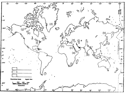
Answer:
A. Addis Ababa: Capital of Ethiopia a country situated in East Africa.
B. Vladivostok: Terminal point of Trans-Siberian railway and an important urban- Industrial center of Soviet far East.
C. Mt. Catapaxi: Highest active volcanic mountain of the world situated in Ecuador Highlands (Andes).
D. Mt. Gunnbjorn: A mountain peak located in South Eastern coast of Greenland.
E. Pidurutalgala: Highest mountain peak of Sri Lanka situated in Central highlands.
F. Amu Darya: An inland river originating from Pamir’s knot and draining into Ural Sea forms boundary between Afghanistan and Tajikistan and Uzbekistan and Turkmenistan.
G. Long Island: Situated in the eastern coast of North America, New York is partly located on it.
H. Nubian Desert: A hot desert situalted east of River Nile in Norty East Sudan (Africa).
I. Karkloof Waterfall: Located on the karkloof range of hills, in the Natal Province of South Africa.
J. Yellow Sea: A marginal sea of western Pacific Ocean situated between Chinese coast and Korean Peninsula ; Hwang-Ho river drains into it.
K. Great Bear Lake: An important fresh water lake in North Canada formed of glacial action; Port Radium having abundant radium and uranium deposits is situated on its bank.L. Welland Canal: Joins lakes Erie and Ontario enabling Great lakes waterways to reach Atlantic through St. Lawrence river.
Q8. On the outline map of the world provided, mark the following and also write in your answer-book in not more than ten words, what you consider to be the most significant aspect of each of them: (1999)
a. Greenwich
b. Carribean Sea
c. Eritrea
d. West Bank
e. Dakshin Gangotri
f. Vatican City State
g. Great Dividing range
h. Tai-pei
i. Alaska
j. Chagai hills
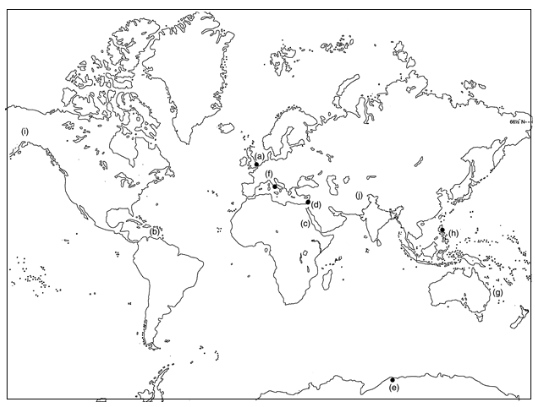
Answer:
A. Greenwich: Lacated in London, constitutes the Prime Meridian (0º Longitude) from which the world’s time zones are calcutated.
B. Carribean Sea: Located to the South-East of gulf of Mexico in the North Atlantic ocean; characterised by high salinity; comprises many important islands like Cuba, Jamaica, Antigua, Trinidad etc.
C. Eritrea: A country located in East Africa on the South-West coast of Red Sea having capital at Asmera.
D. West Bank: Located to the west of Jordan river, bounded by Israel on North, West and South administered by Palestinian Authority but affected by unrest and frequent intervention by Israel.
E. Dakshin Gangotri: Indian scientific research station on the northern edge of the Antarctica continent, close to 0° longitude.
F. Vatican city state: This country with smallest population in the world is situated in the confines of Rome in Italy, constitutes the Headquarter of the Pope, Head of the Roman Catholics in the World.
G. Great Dividing Range: A mountain range parallel to the East coast of Australia, Mt. Kosciusko is its highest peak.
H. T’ai-pei: Capital of Taiwan.
I. Alaska: One of the states of U.S.A. located in the North-Western corner of North America, with Canada to the East, rich in Petroleum
J. Chagai hills: A nuclear test site of Pakistan located in western Pakistan, close to Pakistan-Afghanistan border.
Q9. On the world map provided, mark the following and write in not more than ten words in your answer book, what you consider to be the most significant aspect of each one of them: (1998)
a. Caspian Sea
b. Hwang Ho River
c. Gulf of Oman
d. Madagaskar Island
e. Appalachian Mountain
f. Gibson desert
g. Sicily Island
h. Palk Strait
i. Dogger Bank
j. Amazon River
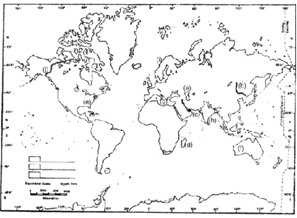
Answer:
A. Caspian Sea: Largest lake in the world.
B. Hwang Ho River: Second longest river of China, notorious for flood, drains into gulf of Bo-hai.
C. Gulf of Oman: Connects Arabian sea with Persian Gulf, a vital trade route.
D. Madagaskar Island: Largest island of Indian Ocean.
E. Appalachian Mountain: A Hercynian fold mountain system of North America, important for coal.
F. Gibson Desert: Central belt of west Australian desert consisting of sand dunes and salt marshes.
G. Sicily Island: Largest Mediterranean island, part of Italy, famous for citrus fruits.
H. Palk strait: Connects gulf of Mannar and bay of Bengal.
I. Doggar Bank: Most vigorously exploited area of North sea for fishing.
J. Amazon River: Largest river system in the world, drains into South Atlantic.
Q10. On the world map provided, mark the following and write in not more than ten words in your answer-book what you consider to be the most significant aspect of each one of them: (1997)
a. Lake Erie
b. Black Forest
c. New York
d. Jamaica
e. Falkland Islands F.Winnipeg
f. Lake Mansarovar
g. Tigris River
h. Sharjah
i. Areas of Mediterranean climate in Africa
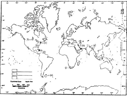
Answer:
A. Lake Erie: Fourth largest lake among the Great Lakes of North America; important
cities like Detroit, Toledo, Cleveland and Buffalo are located on it.
B. Black Forest: An old block mountain situated in S. Germany; flanks the Rhine rift valley.
C. New York: The largest city, situated on the eastern sea-board of USA; noted centre of readymade garments, ship-building and consumer goods.
D. Jamaica: An island republic situated in Carribean Sea; its economy is based on sugar, bauxite and tourism.
E. Falkland Islands: A British crown colony in the Atlantic Ocean; disputed between Argentina and U.K.
F. Winnipeg: An important city situated in the Prairie region of Canada; famous wheat market of the region.
G. Lake Mansarovar: Situated in Tibet; a religious and tourist place; source of Indus, Satluj and Brahmaputra lies nearby.
H. Tigris River: Originates in Turkey and flows parallel to Euphrates in Iraq; formed part of famous mesopotamian civilization.
I. Sharjah: Sharjah is one of the seven Sheikhdoms of United Arab Emirates; third largest shiekhdom; reflects oil rich economy of the nation.
J. Areas of mediterranean climate in Africa: It exists in the Cape Province of South Africa with rainy winters and dry summers the scrub vegetation here is called ‘maquis’.
Q11. On the world map provided, mark the following and write in not more than ten words in your answer-book what you consider to be the most significant aspect of each one of them: (1996)
a. Carribean Sea
b. Atlas Mountains
c. River Rio Grande
d. Titicaca
e. Paris
f. Canaries Current
g. Ougadougou
h. Verkhoyansk
i. Mauritius
j. Melbourne
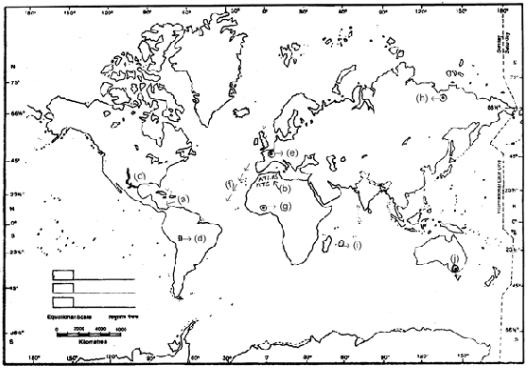
Answer:
A. Carribean Sea: Marginal sea of Atlantic containing Carribean islands, connecting link with Pacific via Panama canal, notorious for huricanes.
B. Atlas Mountain: A young fold mountain chain of Africa bordering mediterranean sea in Morocco, Algeria and Tunisia.
C. River Rio Grande: Forms a natural boundary between USA and Mexico, drains into Gulf of Mexico.
D. Titicaca: This is the highest navigable lake of the world situated along the Peru-colombian border in South-America.
E. Paris: Capital of France, situated on the bank of river Siene, an importnat industrial and fashion centre.
F. Canaries Current: A cold ocean current of Atlantic flowing on the North-Western coast of Africa.
G. Ougadougou: It is the capital and an important industrial centre of Burkina Faso.
H. Verkhoyansk: A place situated in the North-Eastern part of Siberia in Russia where lowest temperatures are recorded.
I. Mauritius: An island-nation in the Indian Ocean, forms part of continent of Africa.
J. Melbourne: Port city of Australia having a variety of industries, important ones being automobiles, aircraft, oil refining and woolen textiles.
Q12. On the world map provided, mark the following and write in not more than ten words in your answer-book what you consider to be the most significant aspect of each one of them: (1995)
a. Danube River B. Leipzig
b. Sierra Nevada D. Washington, D.C.
c. Red Sea
d. Canadian National Railway
e. Ashkhabad
f. Ulan Bator
g. Port Said
h. Pampas
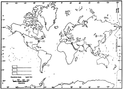
Answer:
A. Danube River: Second longest river in Europe, rises from Black Forest mountains, important for navigation and trade, drain into Black Sea, cities like Viena, Budapest and Belgrade are situated on its bank.
B. Leipzig: Important ancient city situated along the River Elbe in Germany, famous for its optical instruments industry.
C. Sierra Nevada: Part of the Rocky Mountains mainly situated in Eastern California, Mt. Whiteney, the highest peak of mainland USA is located in it.
D. Washington D.C.: It is the capital of USA situated on the eastern part of the mainland.
E. Red Sea: A marginal sea of the Indian Ocean, part of the Great Rift Valley system of Africa, formed by the intra-plate rifting, red colour due to pressence of a red algae, forms a major trade route via Suez canal.
F. Canadian National Railway: An important Trans-Continental Railway, runs from Halifax in Nova Scotia to Prince Rupert via Montreal, Ottawa, Winnipeg and Edmanton.
G. Askhabad: It is the capital of Turkmenistan and an important centre of cotton-textile industry in the country.
H. Ulan Bator: Capital and most important city of Mangolia.
I. Port Said: An important port situated on the northern end of Suez Canal in the Mediterranean sea.
J. Pampas: A temperate grassland situated in Argentina, famous for wheat cultivation and ranching.
In case you still have your doubts, contact us on 9811333901.
For UPSC Prelims Resources, Click here
For Daily Updates and Study Material:
Join our Telegram Channel – Edukemy for IAS
- 1. Learn through Videos – here
- 2. Be Exam Ready by Practicing Daily MCQs – here
- 3. Daily Newsletter – Get all your Current Affairs Covered – here
- 4. Mains Answer Writing Practice – here

