
Contents
- 1 Critical Evaluation of Damodar Valley Corporation (DVC) and Multipurpose River-Basin Planning
- 1.1 Evaluation of DVC against Regional Planning Principles
- 1.2 Conceptual Understanding
- 1.3 The Watershed Approach – An Ecosystem Alternative
- 1.4 1. Concept and Definitions
- 1.5 2. River Basin Approach versus Watershed Approach
- 1.6 3. Ecosystem Dynamics, Homeostasis and Transboundary Management
- 1.7 The Four ‘E’s of Watershed Development
- 1.8 Integrated Rural Development Approach (IRDA/IRDP)
- 1.8.1 1. Concept and Fallacy of Agricultural Growth Equivalence
- 1.8.2 Why Agricultural Growth Alone Is Insufficient
- 1.8.3 2. Water and Land Footprint of Indian Agriculture
- 1.8.4 1. Multidimensional Components of Rural Development
- 1.8.5 2. Rural Connectivity
- 1.8.6 3. Rural Health and Nutrition
- 1.8.7 4. Rural Non-Farm Employment
- 1.8.8 5. Education
- 1.8.9 6. Drinking Water and Sanitation
- 1.8.10 7. Rural Housing and Clean Energy
- 1.8.11 8. Development of Rural Women
- 1.8.12 Gender Focus: Rural Women as a Special Cohort
- 1.8.13 Major Dimensions of Gendered Vulnerability
- 1.8.14 Targeted Policy Interventions
- 1.8.15 Integrated Rural Development Programme and Scheme Linkages
- 1.8.16 Major Rural Development Programme Linkages
- 2 PYQs
Critical Evaluation of Damodar Valley Corporation (DVC) and Multipurpose River-Basin Planning
1. Context and Objectives
The Damodar Valley Corporation (DVC), established in 1948 under the DVC Act, represents one of India’s earliest attempts at integrated river-basin development. Modelled on the Tennessee Valley Authority (TVA), USA, it sought to transform the flood-prone and mineral-rich Damodar basin across present-day Jharkhand and West Bengal. The project emerged from the need to regulate recurrent floods while utilising the region’s water and mineral resources for agricultural and industrial development.
Major objectives:
- Flood control: Regulation of destructive floods in the lower Damodar basin.
- Soil conservation: Afforestation and erosion control in the upper catchment.
- Agricultural development: Irrigation expansion and improved agricultural productivity.
- Energy generation: Hydroelectric and thermal power production.
- Regional transformation: Industrialisation, employment generation and economic development.
2. Regional Problems versus Planning Diagnosis
The central limitation of DVC was the mismatch between the region’s actual socio-economic problems and the development strategy adopted.
A. Actual Problems of the Damodar Region
- Agricultural backwardness: Large sections of the rural population depended on small and marginal holdings, rain-fed agriculture and low-productivity farming. Irrigation and agricultural support were unevenly distributed.
- Tribal deprivation: Indigenous communities experienced limited access to education, healthcare, employment and basic infrastructure. Their dependence on forests and traditional livelihoods made them particularly vulnerable to land-use changes.
- Economic insecurity: Low incomes, limited local employment opportunities and inadequate non-farm activities encouraged distress migration.
- Environmental degradation: Deforestation, soil erosion, mining-related degradation and recurring floods affected agricultural productivity and ecological stability.
- Infrastructure deficits: Rural settlements lacked adequate connectivity, irrigation, healthcare facilities and access to organised markets.
B. Planning Diagnosis and Strategy
The planning approach was based on two major assumptions. Assumption 1: River control would resolve the major regional problem.
- The Damodar was treated primarily as a flood-prone river. Dams, reservoirs and barrages were constructed to regulate its flow and reduce flood damage.
- However, flood control alone could not address agricultural backwardness, rural poverty, land degradation or the absence of local employment.
Assumption 2: Industrialisation would generate regional prosperity.
- The mineral resources of the Chota Nagpur Plateau, particularly coal and iron ore, were considered the foundation for industrial development.
- Heavy industries, power stations and industrial townships were expected to generate employment, increase incomes and stimulate economic activity in the surrounding region.
Faulty Planning Premise: The strategy assumed that flood regulation and industrial growth would automatically produce a trickle-down effect, resolving rural poverty and regional backwardness.
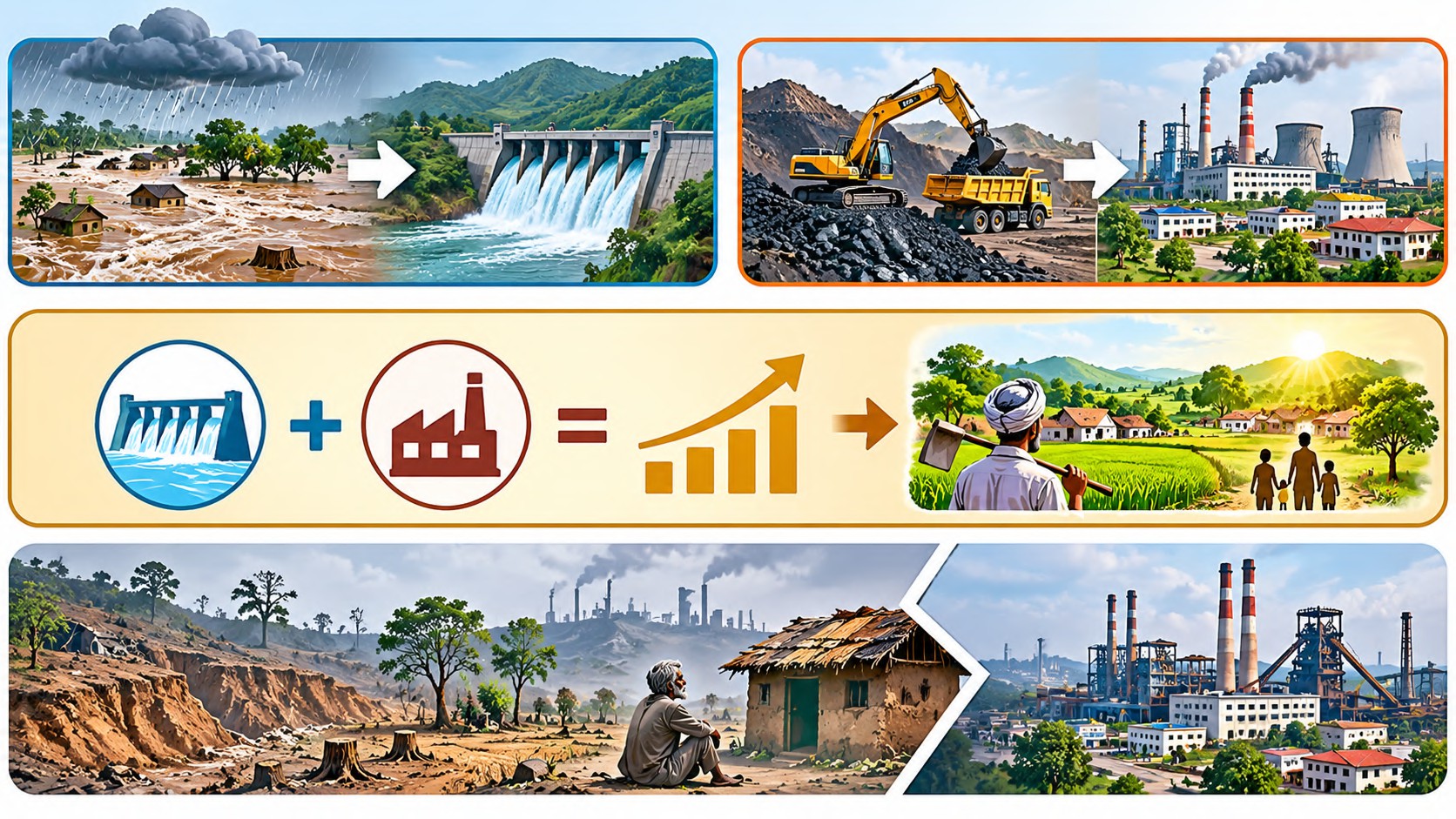
The fundamental limitation was that economic growth was treated as a substitute for comprehensive social and spatial development.
3. Industrial Growth versus Regional Development: The Enclave Paradox
DVC and the wider mineral-based industrial belt contributed significantly to the industrialisation of eastern India. Important industrial and resource centres include:
- Bokaro: Steel manufacturing and industrial township.
- Dhanbad: Coal mining and associated industries.
- Asansol-Durgapur: Industrial, mining and transport corridor.
- Chittaranjan: Locomotive manufacturing.
These industrial nodes strengthened the economic importance of the Chota Nagpur Plateau and adjoining regions. However, industrial growth did not produce equivalent development across the surrounding rural landscape.
A. Enclave Development
- Industrial townships developed as concentrated centres of modern infrastructure, employment and economic activity.
- However, many neighbouring rural and tribal settlements remained poorly integrated with these growth centres.
- This produced the characteristic enclave economy, in which industrial development exists alongside persistent regional poverty.
B. Limited Local Employment
- Heavy industries and mining operations often require specialised technical skills.
- When local education and skill development remain inadequate, employment opportunities may be captured disproportionately by workers from outside the immediate region.
- Consequently, industrial investment does not automatically translate into broad-based local employment.
C. Agricultural and Livelihood Disruption
- Mining, industrial expansion and infrastructure development can affect agricultural land, forests and traditional livelihood systems.
- Where alternative employment, rehabilitation and skill development are inadequate, local communities experience economic insecurity rather than sustained improvement.
D. Unequal Distribution of Benefits
- Industrial output, electricity generation and mineral extraction increased substantially, but the benefits were unevenly distributed.
- The region therefore illustrates the resource-development paradox: abundant natural resources and large capital investments can coexist with low human development.

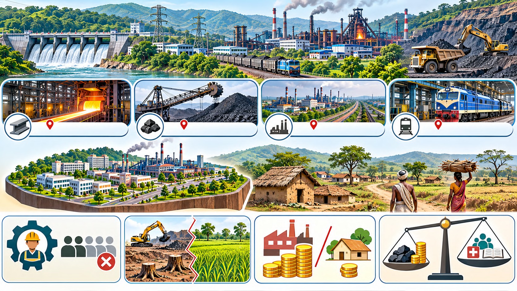
Geographical interpretation: Industrial growth becomes regionally transformative only when its benefits spread beyond the industrial node through employment, local supply chains, infrastructure and livelihood diversification.
4. Mining, Resource Extraction and Local Development
- The wider Damodar-Chota Nagpur industrial belt is one of India’s major coal and mineral-producing regions.
- Mining has supported industrialisation, power generation and employment. However, poorly regulated extraction has also generated high environmental and social costs.
A. Environmental and Social Impacts
- Land degradation: Excavation, overburden dumping and abandoned mining areas create degraded landscapes and reduce the productive use of land.
- Deforestation: Mining and associated infrastructure affect forest cover, biodiversity and the ecological stability of the upper catchment.
- Pollution: Coal mining and industrial activities contribute to air pollution, water contamination and deterioration of local environmental quality.
- Labour exploitation: Informal and illegal mining may expose workers to unsafe working conditions, inadequate protection and exploitative employment arrangements.
- Displacement: Mining and industrial projects can disrupt tribal land rights, agricultural livelihoods and traditional community relationships with forests.
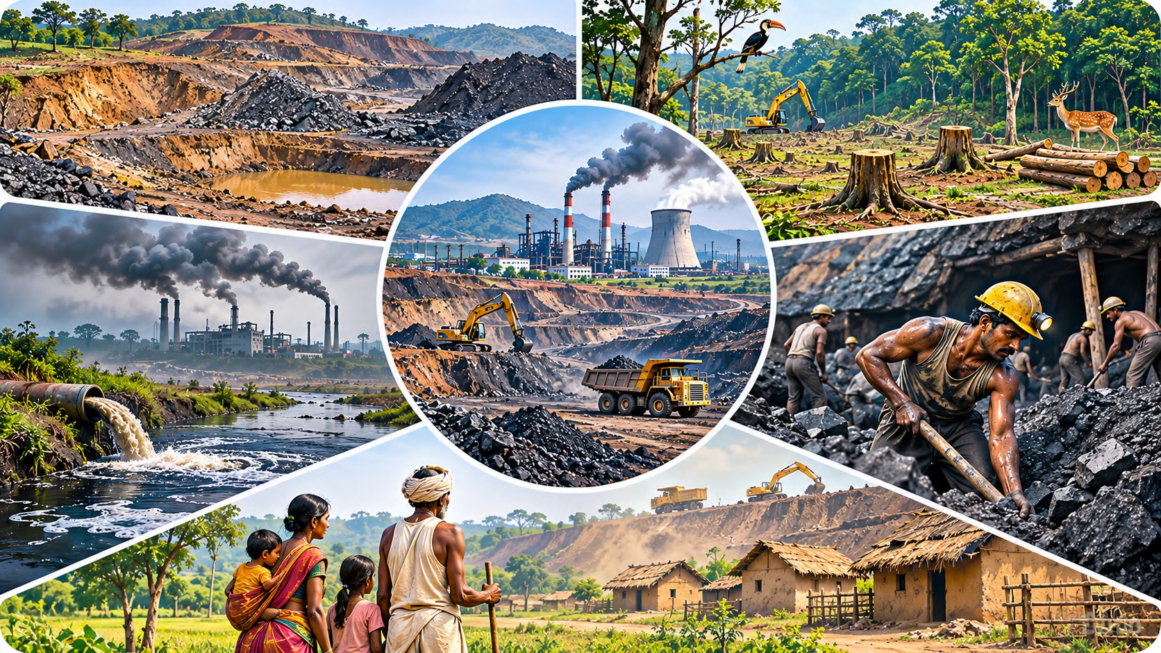
These impacts demonstrate that resource extraction must be evaluated not only through production and revenue but also through its ecological and social consequences.
B. Legislative and Institutional Response
- The Mines and Minerals (Development and Regulation) Act, 1957, provides the principal legislative framework for mineral development and regulation in India.
- A significant institutional development was the introduction of the District Mineral Foundation (DMF) through the MMDR Amendment Act, 2015.
- DMF aims to support the welfare and development of mining-affected areas and communities through statutory contributions from mining leaseholders.
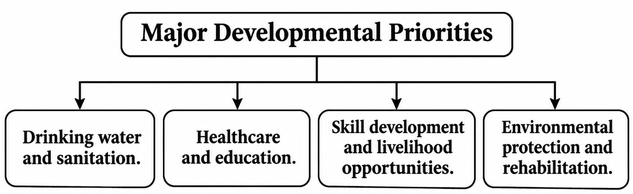
Regional planning significance: DMF attempts to connect mineral extraction with local development by directing resources towards mining-affected communities. However, its effectiveness depends on transparent fund utilisation, community participation, proper identification of affected areas and coordination with local development plans.
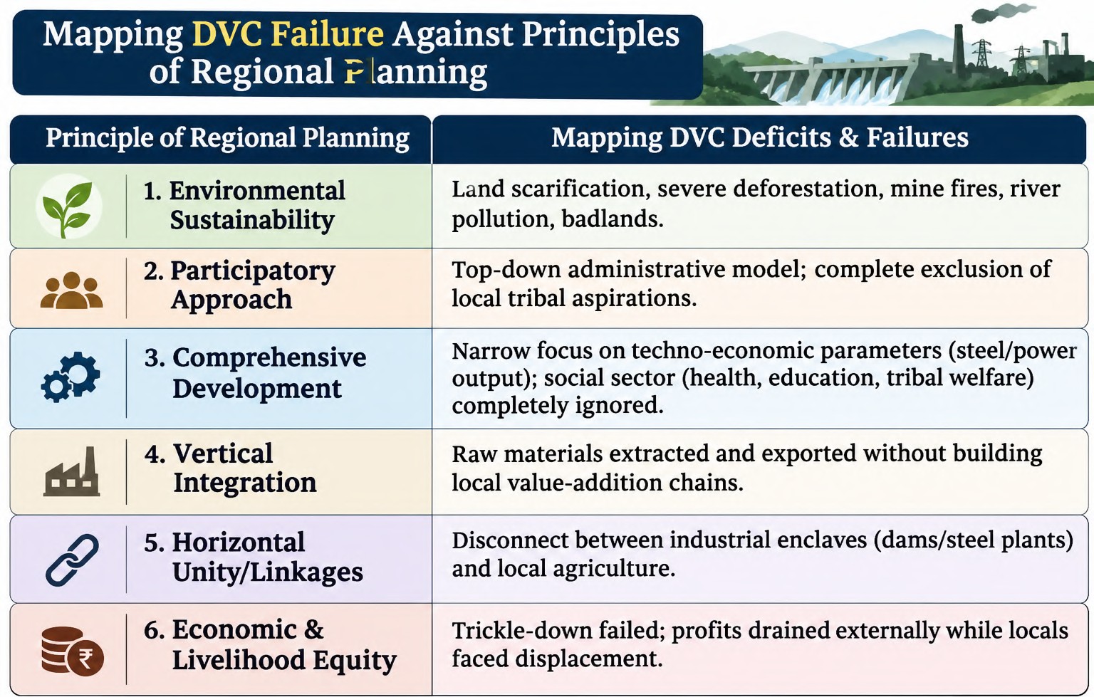
Evaluation of DVC against Regional Planning Principles
Conceptual Understanding
The six principles reveal that DVC’s limitations were not simply the result of insufficient infrastructure. The deeper problem was the absence of adequate integration between: 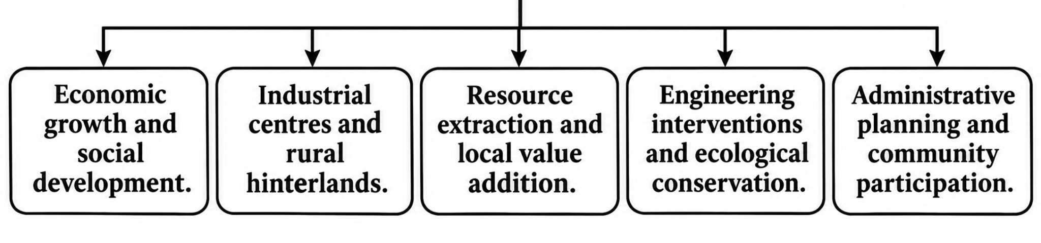
Thus, the project achieved significant sectoral development but fell short of the broader objective of balanced regional transformation.
The Watershed Approach – An Ecosystem Alternative
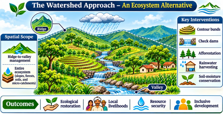
The watershed approach provides an ecosystem-oriented alternative to conventional river-basin planning. It shifts the focus from controlling the river channel through large engineering structures to managing the entire landscape that contributes to runoff, groundwater recharge, soil conservation and ecological stability.
1. Concept and Definitions
Physical or Geo-hydrological Concept: A watershed is a topographically bounded area from which surface runoff drains through a common outlet. It is delineated by ridges, hills and other water divides. The watershed may contain several streams, slopes, forests, agricultural fields and settlements.
Planning or Ecosystem Concept: The Whole-of-Ecosystem Approach (WOEA) treats the watershed as an integrated ecological and socio-economic system. It includes upper slopes, catchment forests, soil, surface water, groundwater, floodplains, biodiversity and local communities.
The central principle is that water cannot be managed independently of the land, vegetation and human activities that determine its movement and availability. Therefore, watershed planning integrates natural resource conservation with agricultural development, livelihood security and community participation.
2. River Basin Approach versus Watershed Approach
The river-basin and watershed approaches differ primarily in their planning philosophy, spatial focus, interventions and institutional arrangements. The conventional river-basin model, illustrated by the DVC experience, emphasises large-scale water regulation and infrastructure. The watershed model focuses on ridge-to-valley management, ecological restoration and decentralised development.
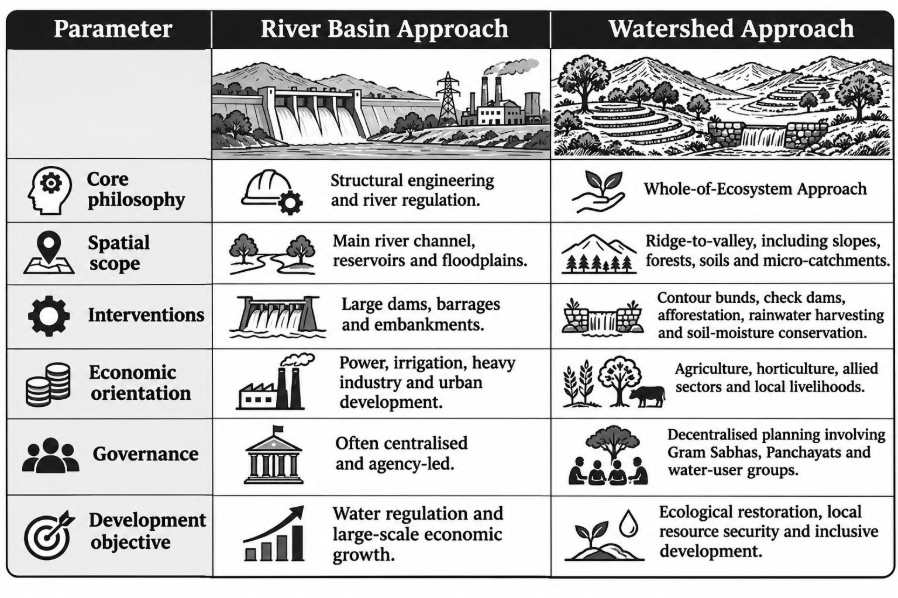
The watershed approach does not reject large dams or river-basin planning. Rather, it complements them by addressing the ecological and social processes that operate across the catchment.
Conceptual Understanding: River-basin planning primarily manages the larger hydrological system, whereas watershed development strengthens the
land-water-vegetation relationships that sustain that system. Effective regional planning requires both scales to function together.
3. Ecosystem Dynamics, Homeostasis and Transboundary Management
- A watershed functions through continuous interaction between its biotic and abiotic components. Forests, crops, fauna and microorganisms interact with soil, rocks, slope, rainfall and water to regulate nutrient cycling, energy flows, infiltration and runoff.
- Homeostasis refers to the capacity of an ecosystem to maintain relative stability through self-regulating processes. In a healthy watershed, vegetation intercepts rainfall, roots bind soil, organic matter improves infiltration and soil moisture supports vegetation. These processes collectively regulate runoff and reduce erosion.
- Unplanned land-use changes, deforestation, excessive extraction and poorly designed engineering interventions can disturb this balance. The consequences may include increased surface runoff, soil erosion, sedimentation, reduced groundwater recharge and greater downstream flood vulnerability. However, such outcomes depend on the nature and scale of intervention; engineering structures can also improve ecological regulation when appropriately designed.
Upstream–Downstream Interdependence
A river system cannot be effectively managed by treating individual administrative stretches as isolated units. Activities in the upper catchment influence water availability, sediment transport and flood behaviour downstream.
- Upstream management: Afforestation, slope stabilisation, contour bunding and sustainable land use improve infiltration and reduce soil erosion.
- Downstream implications: Reduced sediment transport, improved water regulation and better catchment management can benefit agriculture, settlements and infrastructure.
- Institutional requirement: States and local institutions must coordinate water allocation, land management and ecological restoration across administrative boundaries.
Examples:
- Indus Water Treaty: The treaty illustrates the complexities of transboundary water allocation. Its water-sharing framework does not itself constitute comprehensive joint.
- Ganga River Basin: Namami Gange focuses substantially on river rejuvenation, pollution control and the management of the main river system. Effective basin restoration also requires attention to tributaries, Himalayan catchments, forests and local watersheds.
- Siang River, Arunachal Pradesh: Upstream hydropower development and changes in catchment land use can influence sediment movement and downstream hydrological conditions in Assam. The effects depend on project design, reservoir operation and catchment characteristics.
Core Principle: Hydrological connectivity makes upstream and downstream areas interdependent. Sustainable river management therefore requires ecological coordination beyond political and administrative boundaries.
The Four ‘E’s of Watershed Development
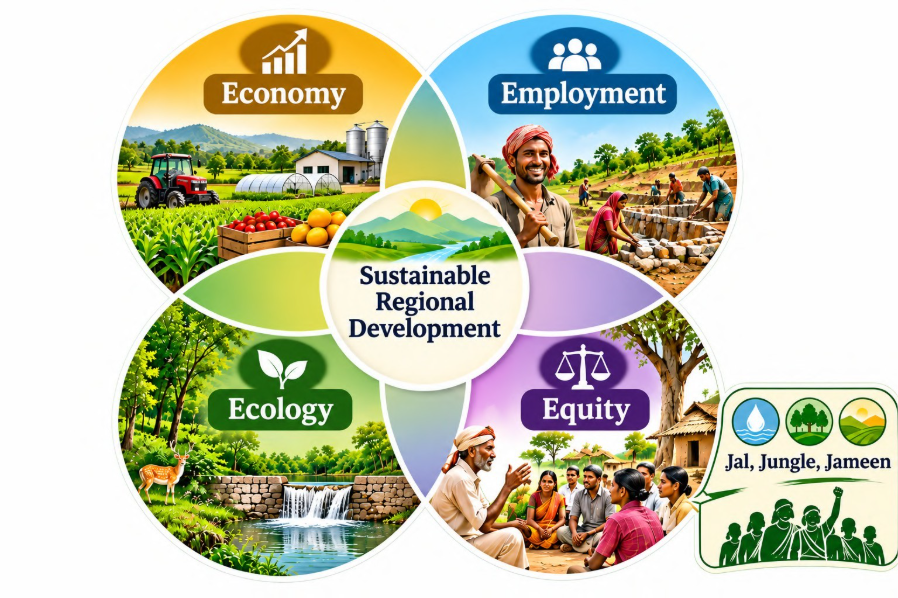
Watershed development aims to achieve sustainable regional development through the integration of Economy, Employment, Ecology and Equity. These four dimensions ensure that resource conservation translates into livelihood improvement and socially inclusive development.
1. Economy
Watershed development strengthens the local economy by improving water availability, agricultural productivity and resource utilisation. Crop diversification, horticulture, livestock, agro-processing and local market linkages reduce dependence on a narrow agricultural base.
2. Employment
Improved soil moisture and water availability support farm employment, while allied activities and rural enterprises create non-farm opportunities. This can reduce distress migration by expanding livelihood choices within the region.
3. Ecology
Ecological restoration includes soil conservation, groundwater recharge, vegetation recovery, biodiversity protection and the restoration of degraded land. These measures improve the long-term productive capacity of the watershed.
4. Equity
Equity ensures that benefits reach marginal farmers, landless households, tribal communities and other vulnerable groups. It includes fair water distribution, participation in decision-making, access to common resources and secure livelihood opportunities.
Example: Jharkhand
The slogan “Jal, Jungle, Jameen” expresses the relationship between water, forests, land and community rights. It resonates with the equity dimension of watershed planning, particularly where tribal livelihoods depend on common natural resources. Watershed development becomes inclusive when conservation benefits are accompanied by meaningful community participation and fair access to resources.
Conceptual Understanding: The four ‘E’s prevent watershed development from becoming merely a technical exercise in water conservation. They connect ecological improvement with economic viability, employment generation and social justice.
1. Scale of Planning and Traditional Water Management
- Watershed planning is most effective when the intervention scale corresponds to the ecological unit and the capacity of local institutions. Micro-watersheds allow communities to identify local problems, prioritise interventions, implement conservation measures and maintain structures.
- Gram Sabhas, Panchayats and water-user associations can support decentralised planning. However, local participation must be accompanied by technical assistance, adequate funding, transparent institutions and coordination with higher administrative levels.
Traditional Water Management Practices
Traditional systems demonstrate how communities adapted water management to local topography, climate and material availability.
- Surangams of Kerala and Karnataka: Horizontal tunnels excavated into laterite hills intercept groundwater and convey it by gravity. They are particularly suited to parts of the laterite terrain of northern Kerala and adjoining Karnataka.
- Johads and Baolis of Rajasthan: Johads are small earthen structures that collect runoff and support groundwater recharge. Baolis or stepwells provide water storage and access, particularly in water-scarce regions. Their functions differ, but both reflect adaptation to arid and semi-arid conditions.
- Bamboo Drip Irrigation of Meghalaya: Bamboo channels distribute water by gravity from streams or springs to agricultural plots and horticultural crops. The system demonstrates low-cost, locally adapted water management in steep terrain.
These practices highlight the importance of local knowledge, appropriate technology and community maintenance. Traditional structures can complement modern watershed interventions, although their effectiveness depends on local geology, rainfall and management.
2. National Programmes and Successful Case Studies
A. Policy Integration in India
- Watershed management has been incorporated into several rural development and natural resource conservation programmes.
- The National Watershed Development Project for Rainfed Areas (NWDPRA) supported integrated watershed development in rainfed regions. Watershed-based interventions were also implemented through programmes addressing drought-prone areas, desert development, wasteland restoration and hill-area development.
Important programme linkages include:
- Drought-Prone Area Programme (DPAP): Focused on reducing the effects of drought through natural resource development and livelihood improvement.
- Desert Development Programme (DDP): Addressed desertification, land degradation and resource scarcity in desert regions.
- Wasteland Development Programme: Promoted the restoration and productive use of degraded lands.
- Hill Area Development Programmes (HADP): Addressed the specific ecological and developmental challenges of hill regions, including soil conservation and natural resource management.
These programmes reflect the shift towards treating land, water and vegetation as interconnected components of regional development.
B. Successful Case Studies
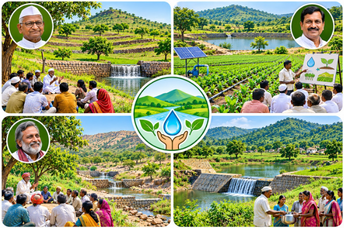
- Ralegan Siddhi, Maharashtra
- Associated with Anna Hazare, Ralegan Siddhi demonstrates the role of community mobilisation and watershed structures in transforming a drought-prone village. Measures included contour bunding, water harvesting, soil conservation and community regulation of resource use.
- The improvement in water availability supported agricultural development and strengthened local livelihoods. The case illustrates how ecological restoration can become the foundation of rural economic transformation.
2. Hiware Bazar, Maharashtra
- Associated with Popatrao Pawar, Hiware Bazar adopted watershed development alongside collective management of agricultural resources. Water conservation, improved farming practices and community decisions regarding water-intensive crops helped improve agricultural productivity and local livelihoods.
- The case highlights the importance of demand-side water management. Conservation is more sustainable when communities regulate not only water supply but also the pattern of water consumption.
3. Arvari River Rejuvenation, Rajasthan
- The Arvari catchment in Alwar district became a prominent example of community-led water conservation associated with Rajendra Singh and Tarun Bharat Sangh.
- The construction and restoration of johads improved water retention and groundwater recharge, contributing to the revival of seasonal stream flows in the Arvari system. The Arvari Sansad, a community-based water governance institution, illustrates the importance of collective rules and local participation in managing shared resources.
- The case demonstrates that watershed restoration requires both physical structures and institutions capable of regulating resource use.
4. Sukhomajri, Haryana
- Sukhomajri, located in the Shivalik foothills, became an important example of integrated watershed management and community-based resource conservation.
- Small earthen dams and soil-conservation measures reduced runoff and erosion, while water harvesting supported agricultural development. The project also linked conservation with village-level benefit sharing, demonstrating the importance of equitable access to resources.
- The case highlights the relationship between upper-catchment treatment, reduced soil erosion and downstream benefits.
Integrated Rural Development Approach (IRDA/IRDP)
1. Concept and Fallacy of Agricultural Growth Equivalence
Integrated Rural Development treats rural development as a multidimensional process involving economic growth, employment, social infrastructure, human development and ecological sustainability. It moves beyond the traditional assumption that agricultural growth alone is equivalent to rural development.
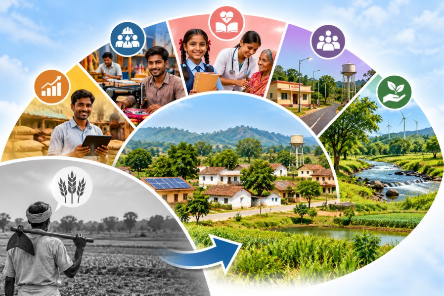
Historically, rural development was often assessed through agricultural productivity, crop yields and foodgrain production. However, higher agricultural output does not automatically improve the overall quality of rural life.
Why Agricultural Growth Alone Is Insufficient
- Employment limitation: Agriculture cannot absorb the entire rural workforce, particularly where landholdings are small and agricultural labour is seasonal. Rural development therefore requires non-farm employment in manufacturing, services, processing and rural enterprises.
- Social infrastructure deficit: Agricultural growth does not automatically provide schools, healthcare facilities, sanitation, housing or safe drinking water.
- Ecological degradation: Intensive and poorly managed agriculture can contribute to groundwater depletion, soil salinisation, chemical contamination and eutrophication.
- Multidimensional poverty: Higher crop yields do not necessarily eliminate illiteracy, malnutrition, gender inequality, poor healthcare or inadequate access to basic services.
Conceptual Understanding: Agricultural development is an important component of rural development, but it is not its complete measure. Integrated Rural Development combines productive growth with social infrastructure, employment diversification, ecological sustainability and equitable access to development benefits.
2. Water and Land Footprint of Indian Agriculture
Indian agriculture depends heavily on land and water resources. Its development must therefore be evaluated in terms of both agricultural productivity and the sustainability of resource utilisation.
Key Data for Revision
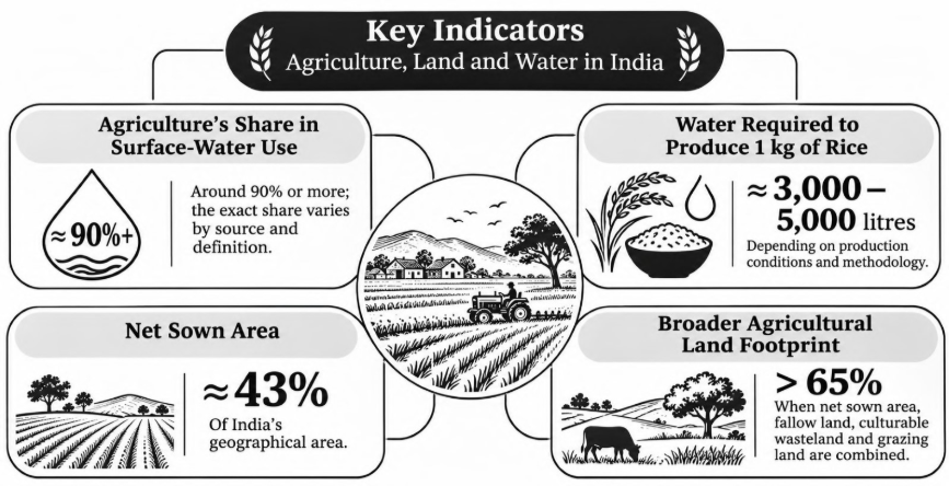
Interpretation: Agriculture occupies a substantial proportion of India’s land and accounts for the dominant share of freshwater withdrawals. This creates a development challenge: increasing agricultural productivity while reducing resource stress.
The water requirement of rice varies with rainfall, irrigation practices, soil conditions and the method used to calculate water consumption. Similarly, the broader agricultural land footprint includes categories that are not necessarily cultivated during a particular year.
Planning Implication: Rural development must promote efficient irrigation, groundwater recharge, crop diversification, soil conservation and water-sensitive agricultural practices. The objective is not merely to increase production but to improve productivity per unit of land and water.
1. Multidimensional Components of Rural Development
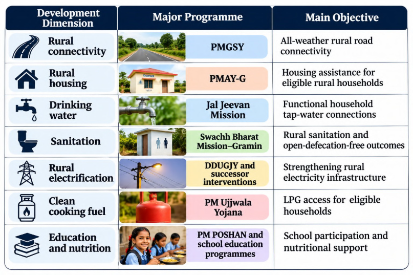
Integrated Rural Development requires coordinated intervention across seven major dimensions. These dimensions address the interconnected causes of rural deprivation and ensure that economic improvement is accompanied by human development.
2. Rural Connectivity
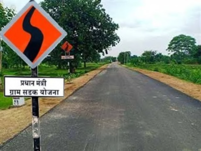
All-weather roads connect villages with agricultural markets, schools, healthcare facilities and employment centres. Improved connectivity reduces transport costs, facilitates the movement of agricultural produce and strengthens rural-urban linkages. Example: Pradhan Mantri Gram Sadak Yojana (PMGSY) promotes rural road connectivity.
3. Rural Health and Nutrition
Primary healthcare, immunisation, maternal healthcare and nutritional support improve human capital and reduce vulnerability. Healthier populations are better equipped to participate in productive activities.

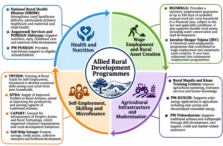
Examples: National Rural Health Mission (NRHM), Anganwadi Services and POSHAN Abhiyaan.
4. Rural Non-Farm Employment
Skill development and occupational diversification reduce excessive dependence on seasonal agricultural labour. Rural manufacturing, food processing, services, handicrafts and allied activities create additional income opportunities. This component is particularly important for landless households, marginal farmers and rural youth.
5. Education
Primary and secondary education improves literacy, skills and social mobility. School infrastructure and nutritional support help reduce barriers to educational participation.
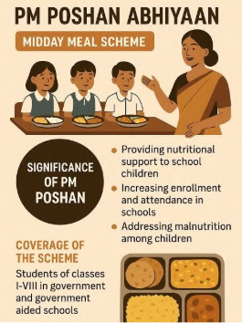
Example: The school meal programme, now known as PM POSHAN, supports nutritional security among eligible schoolchildren.
6. Drinking Water and Sanitation
Safe drinking water and sanitation improve public health, reduce disease burden and lessen the time spent collecting water. These services are especially important for rural women and children.
Examples: Jal Jeevan Mission and Swachh Bharat Mission–Gramin.
7. Rural Housing and Clean Energy

Pucca housing, electricity and clean cooking fuel improve living conditions and reduce environmental and health risks associated with inadequate housing and traditional biomass use.
Examples: Pradhan Mantri Awas Yojana–Gramin (PMAY-G), rural electrification programmes and Pradhan Mantri Ujjwala Yojana.
8. Development of Rural Women
Women’s development must be treated as a central component of rural planning rather than a supplementary welfare activity.
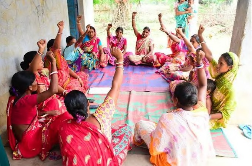
Access to education, healthcare, financial resources, employment and decision-making improves household welfare and strengthens the rural economy.
Examples: Self-Help Groups
(SHGs), women’s livelihood programmes and financial inclusion initiatives.
Conceptual Understanding: These seven dimensions are mutually reinforcing. Roads improve access to schools and markets; education and health strengthen human capital; water and energy reduce household drudgery; employment and women’s empowerment improve income security.
Gender Focus: Rural Women as a Special Cohort
Rural women experience poverty through both economic deprivation and unequal access to resources, services and decision-making. Their vulnerability is intensified by unpaid care work, limited asset ownership and dependence on informal employment.
Major Dimensions of Gendered Vulnerability
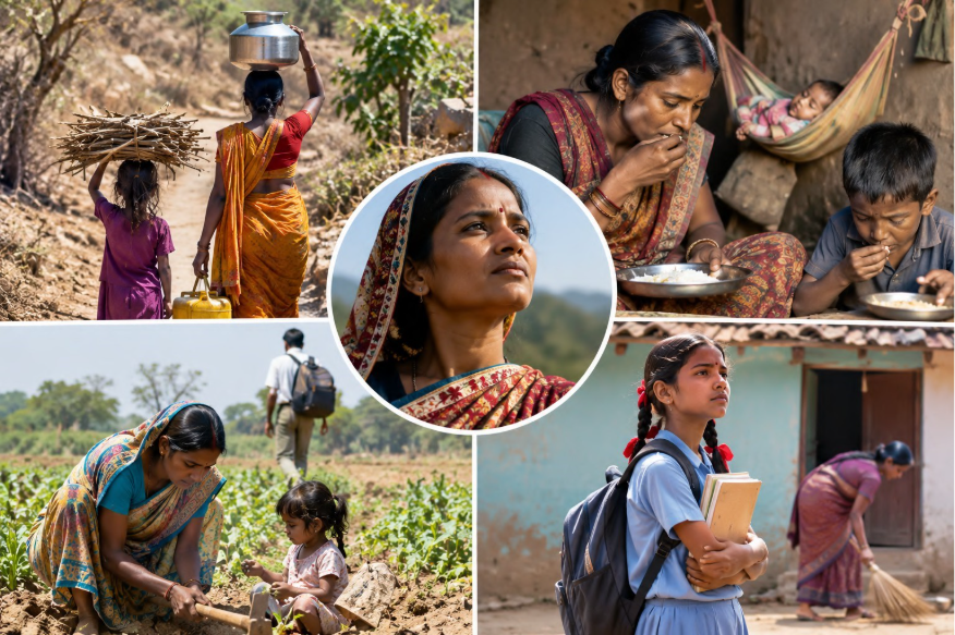
- Water and Energy Drudgery: Women often bear a disproportionate responsibility for collecting drinking water, fuelwood and household resources. Inadequate infrastructure increases their time burden and restricts opportunities for education and paid employment.
- Nutritional Vulnerability: Unequal food distribution within households, inadequate healthcare and reproductive health demands can increase nutritional risks among women. Maternal nutrition is particularly important for both women’s health and child development.
- Distress Male Out-Migration: When men migrate for employment, women may assume responsibility for farms, households and children. However, the absence of formal land titles, credit access and institutional support can limit their ability to manage agricultural resources effectively.
- Educational Exclusion: Girls may face barriers arising from household responsibilities, inadequate sanitation, safety concerns and economic constraints. These barriers can reduce school attendance and reinforce intergenerational poverty.
Targeted Policy Interventions
- Anganwadi Services and POSHAN Abhiyaan: Support maternal and child nutrition, early childhood care and nutrition-related services.
- Self-Help Groups: Promote savings, credit access, collective enterprise and women’s participation in local economic activities.
- Financial Inclusion: Improve access to banking, credit and livelihood support.
- Education and Health Services: Strengthen girls’ educational participation, maternal healthcare and reproductive health support.
The Annapurna Scheme should not be presented as a dedicated scheme for pregnant and nursing mothers. It is associated with food-grain assistance to eligible senior citizens; maternal and child nutrition is better discussed through Anganwadi Services, POSHAN Abhiyaan and related health programmes.
Core Principle: Rural women’s empowerment requires moving beyond welfare provision towards control over productive assets, financial resources, livelihood opportunities and local decision-making.
Integrated Rural Development Programme and Scheme Linkages
The Integrated Rural Development Programme (IRDP) was introduced in selected areas during 1978–79 and extended across the country in 1980. It aimed to assist rural poor households through productive assets, subsidies and institutional credit.
Its central objective was to enable eligible households to cross the poverty line through self-employment and income-generating activities.
IRDP represented a shift from isolated sectoral interventions towards household-level poverty alleviation. However, its effectiveness was constrained in many areas by inadequate beneficiary identification, insufficient support services, weak asset productivity and limited market linkages.
Major Rural Development Programme Linkages
Rural development programmes expanded across infrastructure, housing, sanitation, energy, health and education. These programmes should be understood as complementary interventions, not as components all formally subsumed under IRDP.
PYQs
- Present an account of the experience of regional planning in India in the context of Damodar Valley. (2003)
- Discuss the policies and programmes of Integrated Rural Development Programmes in India. (2007)
- What is meant by integrated rural development planning? What are its components? What has been the extent of its success in relation to its objectives? (1990)
- Discuss the strategies of integrated development of island territories in India. (15 Marks/2018)
In case you still have doubts, contact us at 9773890604
Enrol in Geography Optional by Shabbir Sir: Here
Enrol in One-on-One Personalised Mentorship: Here
Enrol in GS Mentorship Program: Here
Enrol In GS Mains Mentorship Program: Here
Explore One Integrated Platform for UPSC Prep: Yooki
Visit our YouTube Channel: Here