Contents
- 1 Fundamentals of Geomagnetism
- 2 Phenomena and Features Associated with Earth’s Magnetosphere
- 3 Concepts Related to Geomagnetism
- 4 Paleomagnetism
- 4.0.0.1 1. How can a rock record a magnetic field?
- 4.0.0.2 2. Recording magnetism in cooling lava
- 4.0.0.3 3. What information does paleomagnetism provide?
- 4.0.0.4 4. Magnetic reversals: when polarity changes
- 4.0.0.5 5. How paleomagnetism supported continental drift
- 4.0.0.6 6. How paleomagnetism proved important for seafloor spreading
- 4.0.0.7 7. Other major applications
- 4.0.0.8 8. Limitations: why the record must be tested
- 5 PYQs
- 5.0.1 Evidences from paleomagnetism and seafloor spreading have validated that continents and ocean basins have been stationary. Elucidate with suitable diagrams . (20 marks/2023)
- 5.0.2 Write short note on Geomagnetism and Paleomagnetism. (2011)
- 5.0.3 In case you still have your doubts, contact us on 9773890604
Fundamentals of Geomagnetism
Geomagnetism refers to the study of Earth’s magnetic field, including its origin, characteristics, variations and significance. Earth behaves approximately like a giant bar magnet, with a magnetic field extending from its interior into surrounding space. This magnetic field is generated mainly by the movement of electrically conducting molten metals in Earth’s outer core. It plays an important role in protecting Earth from charged solar particles, supporting navigation and providing evidence about Earth’s geological history.
1. Core Ideas of Geomagnetism
A. Dipole Behaviour of Earth’s Magnetic Field
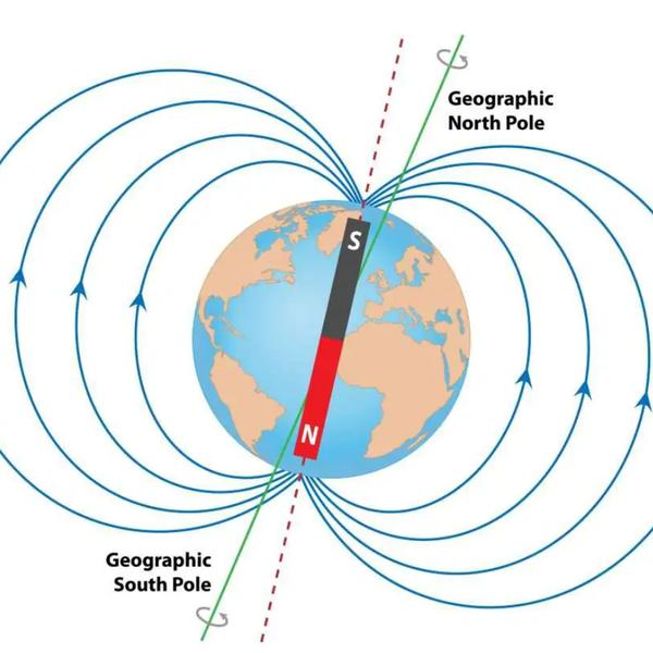
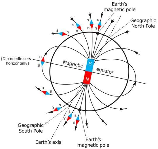
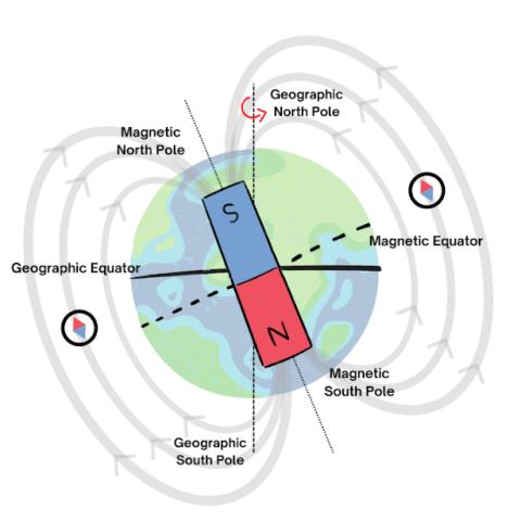
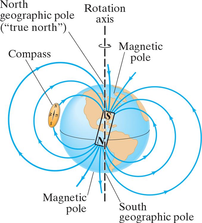
- Earth behaves approximately like a magnetic dipole, meaning its magnetic field resembles that of a bar magnet having two opposite magnetic poles.
- The magnetic field extends from Earth’s interior into space, forming curved magnetic field lines around the planet.
- Outside Earth, magnetic field lines approximately emerge near the Southern Hemisphere’s magnetic pole and enter near the Northern Hemisphere’s magnetic pole.
- Earth’s magnetic poles are not identical to its geographical poles. The geographical poles are determined by Earth’s rotational axis, whereas the magnetic poles are associated with its magnetic field.
- The magnetic dipole axis is tilted by approximately 9–10° relative to Earth’s rotational axis. Therefore, magnetic north and geographical north do not point in exactly the same direction.
- Magnetic poles are not fixed. They gradually change their geographical positions because the movement of molten metals inside Earth’s outer core continuously modifies the magnetic field.
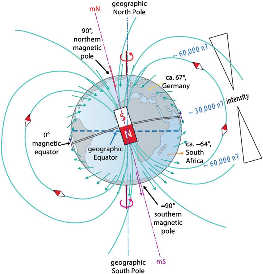 Example: A magnetic compass generally points towards magnetic north rather than true geographical north. Therefore, navigators must consider the difference between the two directions.
B. Genesis of Geomagnetism: Geodynamo Action
The Earth’s magnetic field is generated primarily through a process called the Geodynamo Mechanism, which operates in Earth’s liquid outer core. The outer core is composed mainly of electrically conducting molten iron, along with nickel and lighter elements. The continuous movement of this liquid metal generates electric currents, which sustain Earth’s magnetic field. How does the geodynamo work?
1. Heat from Earth’s interior: Heat escaping from the core, along with energy released during inner-core solidification, creates temperature and compositional differences within the liquid outer core.
2. Convection currents: These differences cause molten metallic material to circulate within the outer core. Hotter or compositionally buoyant material rises, while denser material tends to sink.
3. Influence of Earth’s rotation: Earth’s rotation produces the Coriolis effect, which helps organise the moving liquid metal into rotating and elongated flow patterns.
4. Generation of electric currents: The movement of electrically conducting molten metal through an existing magnetic field induces electric currents through electromagnetic induction.
5. Formation and maintenance of the magnetic field: These electric currents produce additional magnetic fields. Under suitable conditions, the interaction between fluid motion and magnetic fields maintains a self-sustaining geodynamo. 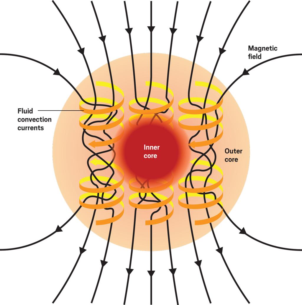 Important: The geomagnetic field is not generated simply because Earth’s core contains iron. It is mainly produced by the continuous movement of electrically conducting liquid metal within the outer core. Thus, the geodynamo can be understood through the relationship: Core heat and compositional buoyancy → Convection of liquid iron → Electromagnetic induction → Electric currents → Geomagnetic field
2. Functional Significance of Geomagnetism
A. Protection of Earth from Solar Radiation
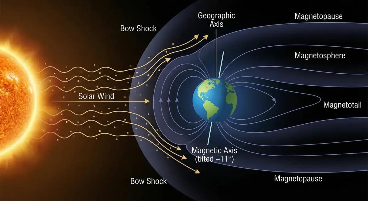
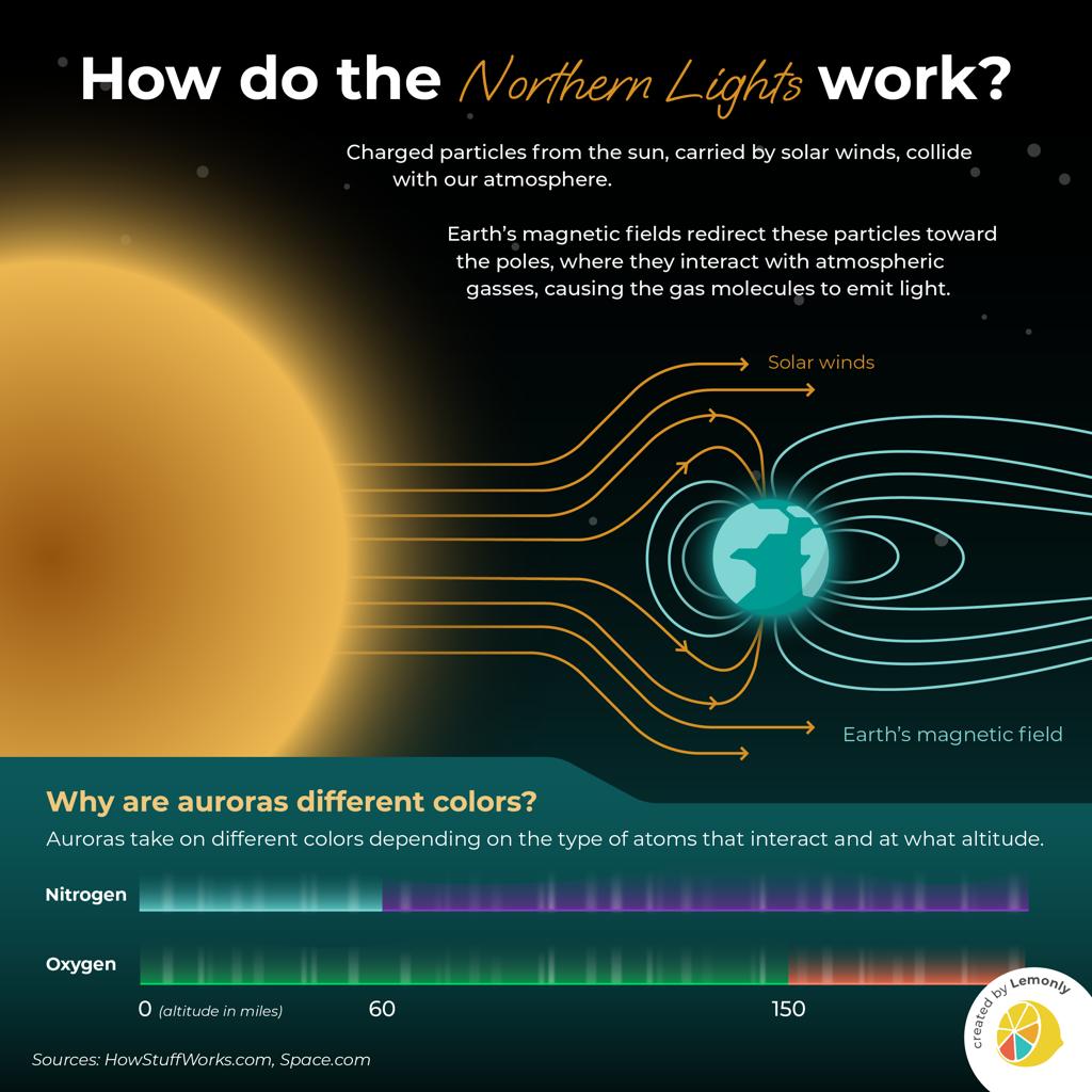
One of the most important functions of Earth’s magnetic field is the formation of the magnetosphere, which protects the planet from many charged particles originating from the Sun.
- The Sun continuously releases a stream of charged particles, mainly electrons and protons, called the solar wind.
- When these charged particles approach Earth, they interact with Earth’s magnetic field.
- The magnetic field redirects many of these particles around Earth, preventing them from directly entering the atmosphere.
- Some charged particles become trapped within regions of Earth’s magnetosphere, while others travel along magnetic field lines towards polar regions.
- Consequently, Earth’s magnetic field helps reduce the direct exposure of the upper atmosphere to energetic charged particles and limits atmospheric erosion associated with the solar wind.
 Example: Mars lacks a strong present-day global dipole magnetic field. Its atmosphere has experienced substantial loss to space over geological time, partly through interactions with the solar wind. This illustrates the potential importance of magnetic shielding, although gravity, atmospheric chemistry and planetary history also influence atmospheric retention. Clarification: Earth’s magnetic field mainly protects against charged particles, not gamma rays or X-rays directly. Protection from much electromagnetic radiation depends primarily on Earth’s atmosphere.
B. Space Weather and Geomagnetic Storms
Space weather refers to changing conditions in the space environment, particularly those caused by solar activity and interactions between solar particles and Earth’s magnetosphere. Strong solar disturbances, especially coronal mass ejections and energetic solar-wind streams, can significantly disturb Earth’s magnetic field. Major consequences include:
- Deformation of the magnetosphere: Solar-wind pressure compresses Earth’s magnetic field on the Sun-facing side and stretches it into a long magnetotail on the opposite side.
- Formation of aurorae: Energetic charged particles entering the upper atmosphere near polar regions collide with oxygen and nitrogen, producing colourful lights called aurorae.
- Disturbance in communication systems: Geomagnetic storms can alter the ionosphere, affecting high-frequency radio communication and satellite navigation signals.
- Satellite-related problems: Energetic particles can damage satellite electronics, while changes in the upper atmosphere can increase atmospheric drag on low-Earth-orbit satellites.
- Power-grid disturbances: Rapid changes in Earth’s magnetic field can induce electric currents in long conductors, including electricity transmission networks, potentially disrupting power supplies.
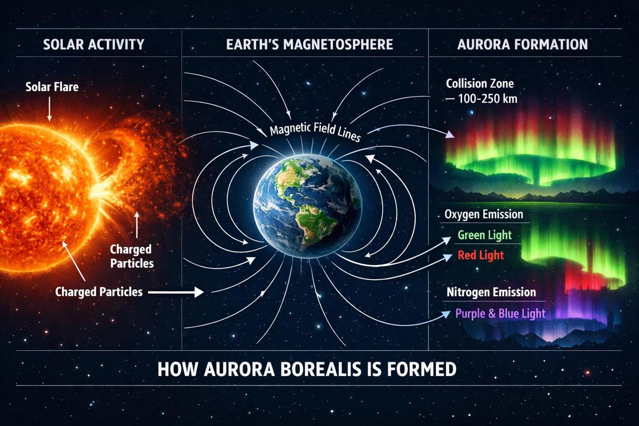
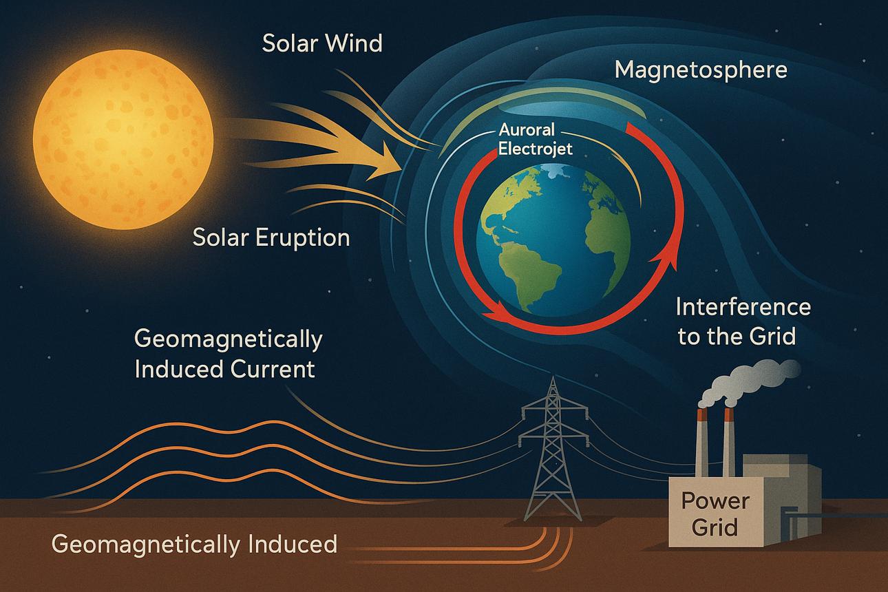
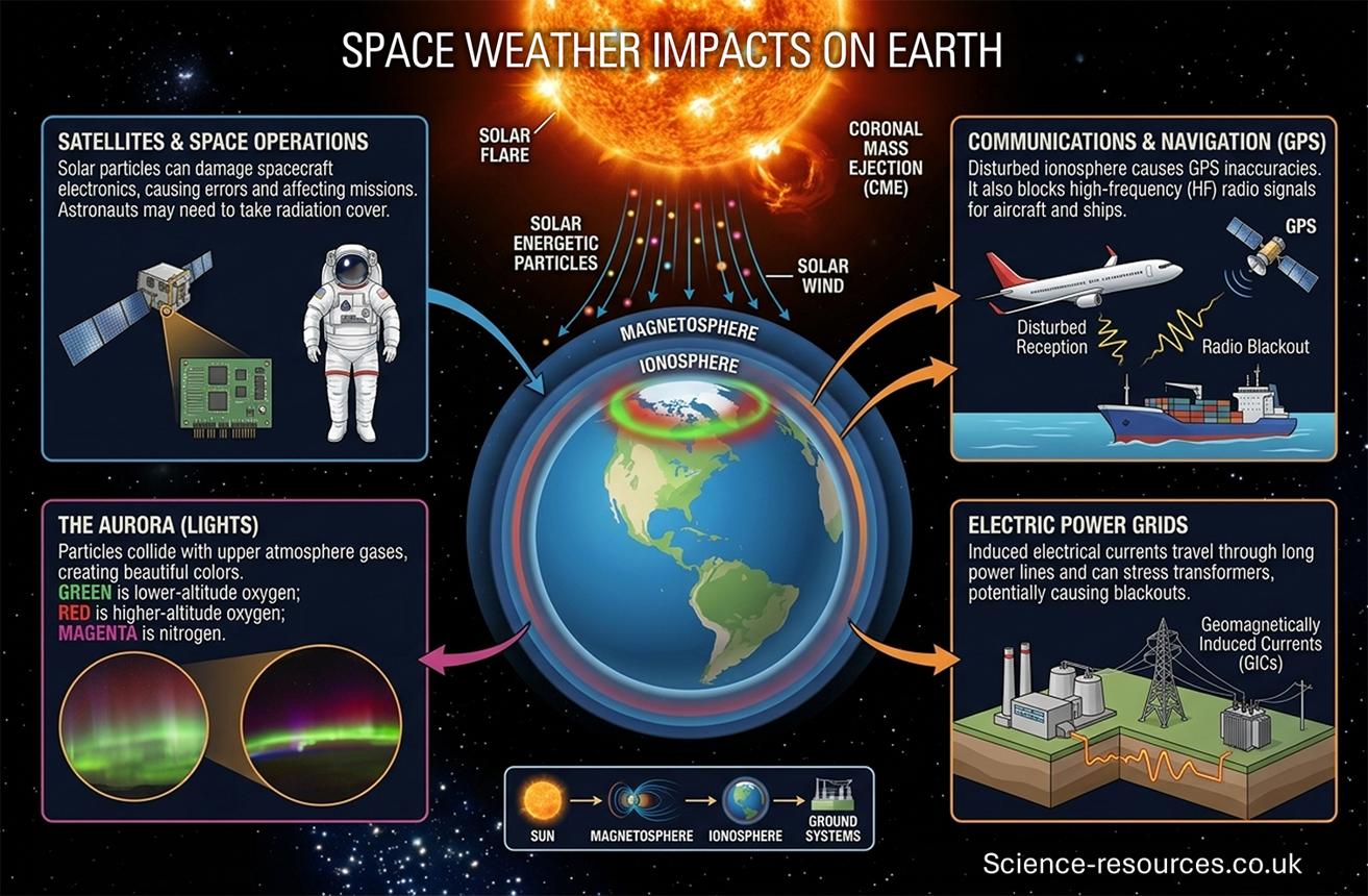
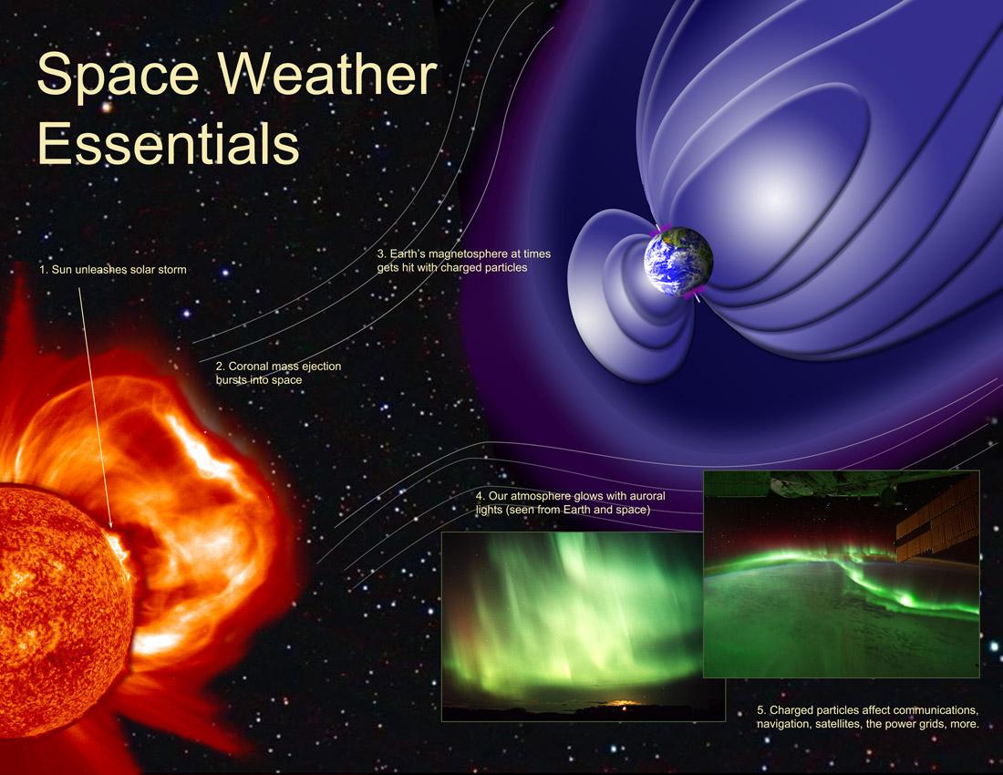 Example: During the Carrington Event of 1859, a powerful geomagnetic storm produced widespread aurorae and disrupted telegraph systems. Similarly, the March 1989 geomagnetic storm contributed to a major electricity blackout in Quebec, Canada. Therefore, geomagnetism is important not only for understanding Earth’s natural protective system but also for assessing the vulnerability of modern technological infrastructure.
3. Observations and Implications of Geomagnetism
The Earth’s magnetic field can be understood through several measurable characteristics. The four important quantities are magnetic intensity, magnetic declination, magnetic inclination and secular variation.
A. Magnetic Intensity
Magnetic intensity refers to the strength or magnitude of Earth’s magnetic field at a particular location.
- Earth’s magnetic field is not equally strong everywhere.
- Its intensity is generally lower near the magnetic equator and higher towards magnetic polar regions.
- The magnetic field strength is commonly measured in nanotesla (nT) or microtesla (µT).
- Typical surface magnetic-field intensities range from approximately 25,000 to 65,000 nT.
Example: Earth’s magnetic field is generally stronger at high magnetic latitudes, such as parts of Canada and Antarctica, than near equatorial regions.
B. Magnetic Declination
Magnetic declination refers to the horizontal angle between the direction of geographical north (true north) and magnetic north, measured at a particular location.
- Geographical north represents the direction towards the geographical North Pole.
- Magnetic north represents the direction indicated by the horizontal component of Earth’s magnetic field.
- Since the geographical and magnetic poles are not at identical locations, these two directions usually differ.
- When magnetic north lies east of true north, it is called easterly declination.
- When magnetic north lies west of true north, it is called westerly declination.
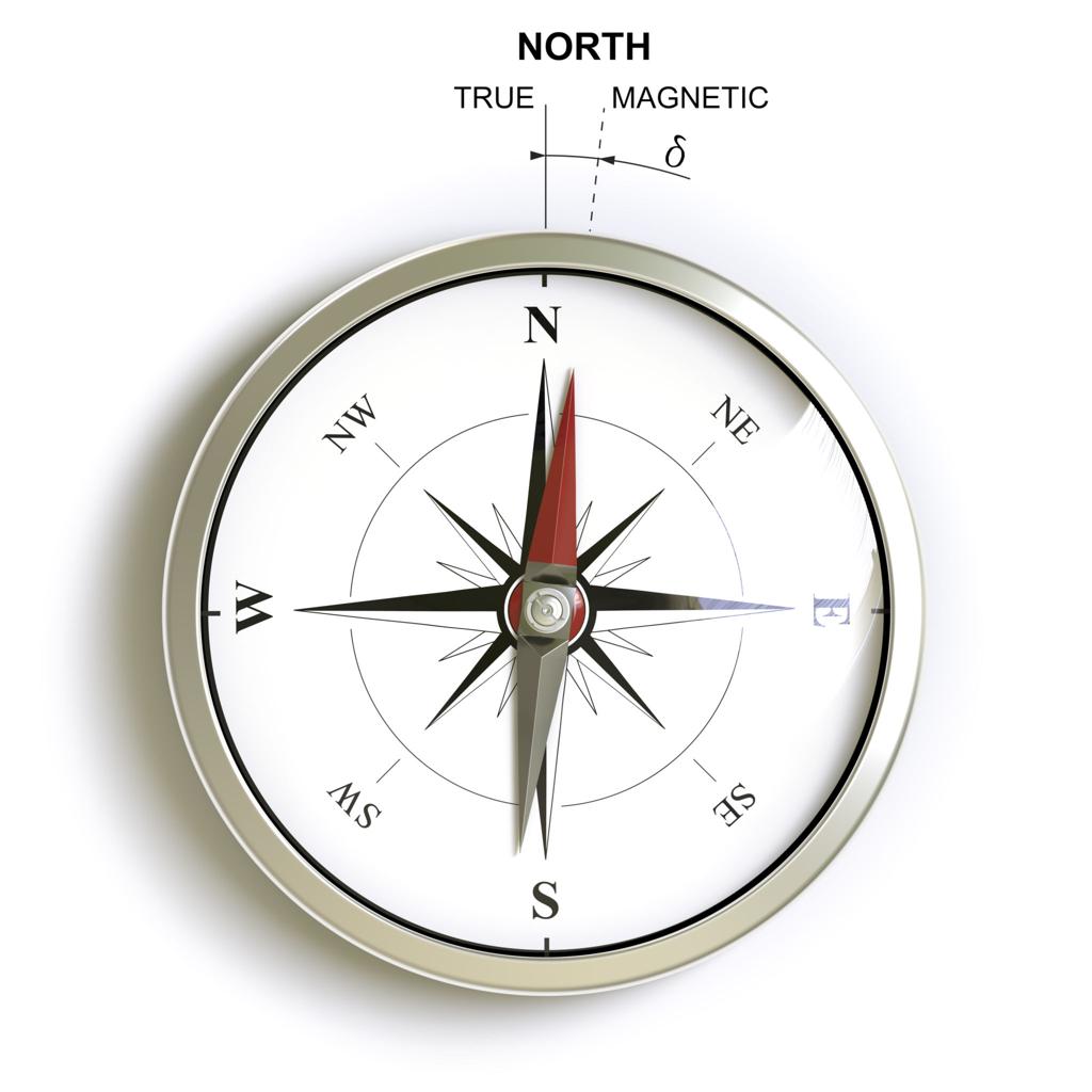 Example: If a compass points 5° east of geographical north, the location has a magnetic declination of 5° east. Significance: Magnetic declination is important for accurate navigation, surveying and converting compass bearings into geographical directions.
C. Magnetic Inclination (Magnetic Dip)
Magnetic inclination refers to the angle that Earth’s magnetic field makes with the horizontal plane at a particular location. Unlike magnetic declination, which describes the horizontal direction of the field, magnetic inclination describes its vertical orientation.
- At the magnetic equator, magnetic field lines are approximately horizontal. Therefore, the inclination is around 0°.
- Moving towards the magnetic poles, field lines become progressively more inclined.
- At the magnetic poles, field lines are approximately vertical, producing an inclination of 90° in magnitude.
- The magnetic field generally points downward in the Northern Hemisphere and upward in the Southern Hemisphere, under the usual magnetic-dip convention.
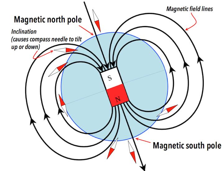
Example: At a location in northern India, a freely suspended magnetic needle would generally dip downward towards the north rather than remain perfectly horizontal. Significance: Magnetic inclination helps determine the three-dimensional direction of Earth’s magnetic field and is particularly useful in palaeomagnetic studies.
D. Secular Variation
Secular variation refers to the gradual changes in the strength and direction of Earth’s magnetic field over years, decades and centuries.
- Earth’s magnetic field is not permanent or completely stable.
- Continuous movements of molten iron within the outer core cause its intensity and direction to change.
- As a result, magnetic declination, inclination and intensity at a given location may change with time.
- Magnetic poles also migrate because of these internal changes.
Example: The north magnetic pole has moved substantially from the Canadian Arctic towards Siberia over the last century. Significance: Secular variation helps scientists understand changes in Earth’s core dynamics and also requires periodic updating of magnetic navigation charts.
4. Applications of Geomagnetism
Geomagnetism provides the scientific basis for magnetic compass navigation.
- A magnetic compass aligns itself with the horizontal component of Earth’s magnetic field.
- It helps determine direction during land and marine navigation.
- Knowledge of magnetic declination allows compass directions to be corrected relative to geographical north.
- Magnetic-field measurements are also used in some orientation and navigation systems.
Example: Ships and aircraft using magnetic headings must account for local magnetic declination to determine directions accurately.
B. Palaeomagnetism: Reconstruction of Plate Movements and Magnetic Reversals
Palaeomagnetism refers to the study of Earth’s ancient magnetic field as preserved within rocks, sediments and archaeological materials. When certain rocks form, their magnetic minerals can acquire a magnetic orientation that reflects the direction of Earth’s magnetic field at that time. How is the magnetic field recorded in rocks?
- When lava cools below the relevant magnetic blocking temperatures, magnetic minerals such as magnetite may preserve the direction of the existing geomagnetic field.
- This preserved magnetic orientation is called remanent magnetisation.
- As tectonic plates move, rocks carrying these magnetic records also change their geographical positions.
- Scientists examine the original magnetic orientation recorded in rocks to reconstruct ancient plate positions, rotations and movements.
Major implications:
- Evidence of continental drift: Palaeomagnetic studies revealed apparent polar-wandering paths, which helped demonstrate the movement of continents.
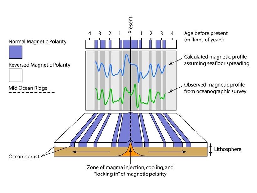
- Evidence of seafloor spreading: Alternating bands of normal and reversed magnetic polarity occur approximately symmetrically on opposite sides of many mid-ocean ridges.
- Reconstruction of ancient latitudes: Magnetic inclination preserved in suitable rocks can help estimate the latitude at which those rocks originally formed.
- Identification of magnetic reversals: Rocks preserve evidence that Earth’s magnetic field has reversed polarity repeatedly during geological history.
Example: Magnetic stripes on the Atlantic Ocean floor provided major evidence supporting Harry Hess’s seafloor-spreading hypothesis and the development of plate tectonic theory.
C. Monitoring Space Weather
Geomagnetic observations are useful for monitoring disturbances created by solar activity.
- Ground-based magnetometers continuously record fluctuations in Earth’s magnetic field.
- These measurements help scientists detect and evaluate geomagnetic storms.
- Observations of magnetic disturbances assist in assessing risks to satellites, communication networks, navigation systems and electricity grids.
- Geomagnetic measurements are combined with solar and satellite observations for space-weather forecasting.
Example: During major solar storms, monitoring agencies use geomagnetic activity measurements to assess the severity of disturbances and issue warnings to infrastructure operators.
D. Studying Core Dynamics
Geomagnetism provides an indirect method for studying processes occurring deep within Earth.
- Earth’s core cannot be directly observed through conventional geological field methods.
- However, changes in the magnetic field provide valuable information about the movement of electrically conducting material inside the outer core.
- By studying magnetic intensity, directional changes and secular variation, scientists can test models of fluid motion and electromagnetic processes within the core.
- Magnetic observations therefore improve understanding of the geodynamo mechanism, its variability and long-term evolution.
Example: Changes in the location of magnetic poles and regional magnetic-field intensity help scientists investigate how fluid flow inside Earth’s outer core is changing.
5. Geomagnetic Reversals and Variability
Earth’s magnetic field is not constant in direction or intensity. Over geological time, it has undergone repeated changes, including complete reversals of its magnetic polarity.
A. Geomagnetic Polarity Reversals
A geomagnetic polarity reversal occurs when the dominant polarity of Earth’s magnetic field changes, so that magnetic north and magnetic south effectively exchange positions. There are two main magnetic polarity states:
- Normal polarity: Earth’s magnetic field has approximately the same polarity as the present-day field.
- Reversed polarity: Earth’s magnetic field has the opposite polarity to the present-day field.
During a reversal, Earth’s magnetic field may weaken and become more complicated, with multiple magnetic-pole-like regions temporarily developing before the field reorganises. 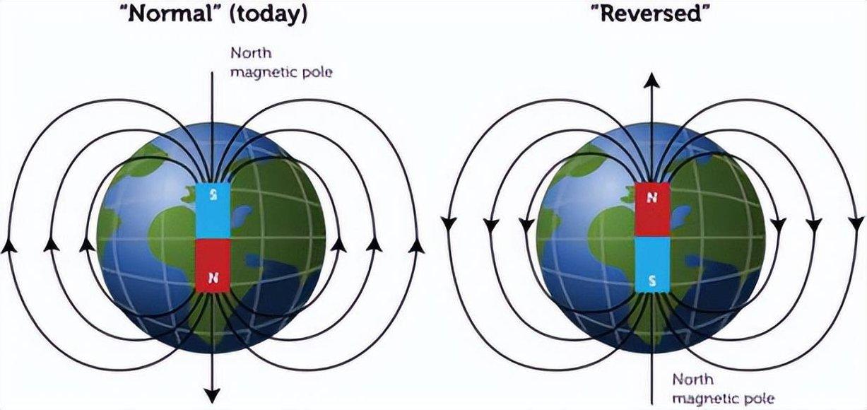 Example: The most recent widely recognised complete geomagnetic reversal was the Brunhes–Matuyama reversal, approximately 773,000 years ago.
B. Recording of Magnetic Reversals in Rocks
When volcanic rocks cool, magnetic minerals can preserve the direction and polarity of Earth’s magnetic field existing at that time.
- If rocks formed during a normal-polarity period, their magnetic minerals can preserve normal polarity.
- If they formed during a reversed-polarity period, they can preserve reversed polarity.
- Successive volcanic rock sequences and ocean-floor rocks therefore provide records of Earth’s magnetic history.
- By comparing these records with independently established geological ages, scientists construct the Geomagnetic Polarity Time Scale (GPTS).
Example: Alternating normal and reversed magnetic stripes on the ocean floor provide evidence of both polarity reversals and the continuous formation of new oceanic crust at mid-ocean ridges.
C. Non-Steady Behaviour of the Geodynamo
The Earth’s geodynamo does not produce a perfectly constant magnetic field. Its behaviour varies because convection currents and fluid movements within the outer core continuously change. This variability is expressed through:
- Changes in intensity: Magnetic-field strength increases or decreases over time.
- Changes in direction: Magnetic declination and inclination vary with time.
- Magnetic pole movement: Magnetic poles gradually change their geographical positions.
- Geomagnetic reversals: Occasionally, the dominant dipole polarity reverses completely.
These changes demonstrate that Earth’s magnetic field is a dynamic phenomenon sustained by continuously evolving processes within the liquid outer core, rather than a fixed magnetic structure.
Phenomena and Features Associated with Earth’s Magnetosphere
Mnemonic for Electromagnetic Spectrum:
GAKSU-VIMAR → Gamma Rays → X-rays → Ultraviolet → Visible → Infrared → Microwaves → Radio Waves
Key Concept:
Among these, only infrared, visible light, and part of the ultraviolet spectrum reach Earth’s atmosphere.
- Gamma rays, X-rays, and high-energy UV are blocked by the magnetosphere and ozone layer.
- Microwaves and radio waves are weak and only partially reach Earth.
Major Phenomena Linked to Earth’s Magnetic Field
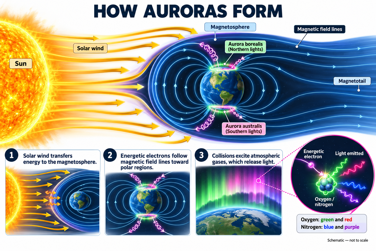
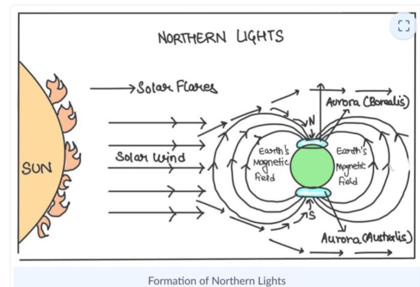
1. Auroras (Aurora Borealis and Australis)
- Result from interaction between solar winds and Earth’s magnetic field near polar regions.
- Charged solar particles (mainly electrons and protons) collide with gases in the upper atmosphere, producing colorful light emissions.
- Occur around magnetic poles, not geographic poles — hence visible in high-latitude regions.
- Common in Arctic (Aurora Borealis) and Antarctic (Aurora Australis) regions.
2. Van Allen Radiation Belts
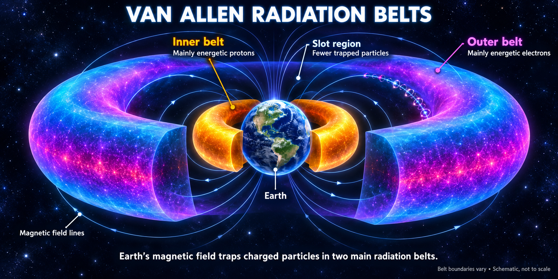
- Definition: Layers of trapped charged particles (electrons and protons) held in place by Earth’s geomagnetic field.
- Formation Process:
~ Solar winds distort the magnetosphere, compressing it on the sunward side and elongating it on the night side.
~ Charged particles get trapped along magnetic field lines forming two distinct belts:
~ Inner Belt: ~12,000 km from Earth’s surface.
~ Outer Belt: Up to ~30,000 km altitude - Importance:
~ Protects Earth from harmful cosmic radiation.
~Affects satellite operations and rocket trajectories—missions to higher orbits or beyond (like lunar missions) must navigate these radiation zones carefully.
3. Angle of Declination and Dip Angle
Angle between magnetic needle and horizontal surface of the Earth. This angle is because the dip angle magnetic lines of force are not concentric circles around the Earth. The lines converge at the poles. 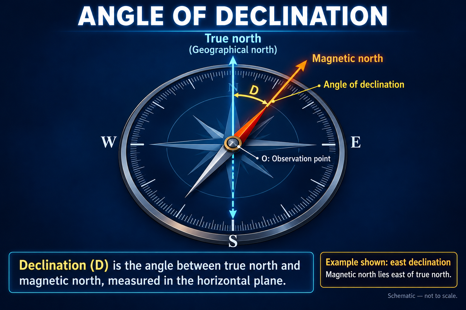 Inclination Angle – Angle between magnetic lines of force and the horizontal. With change of location, the declination angle does not change unless the field orientation changes or Earth’s tilt changes, whereas dip angle can change from place to place.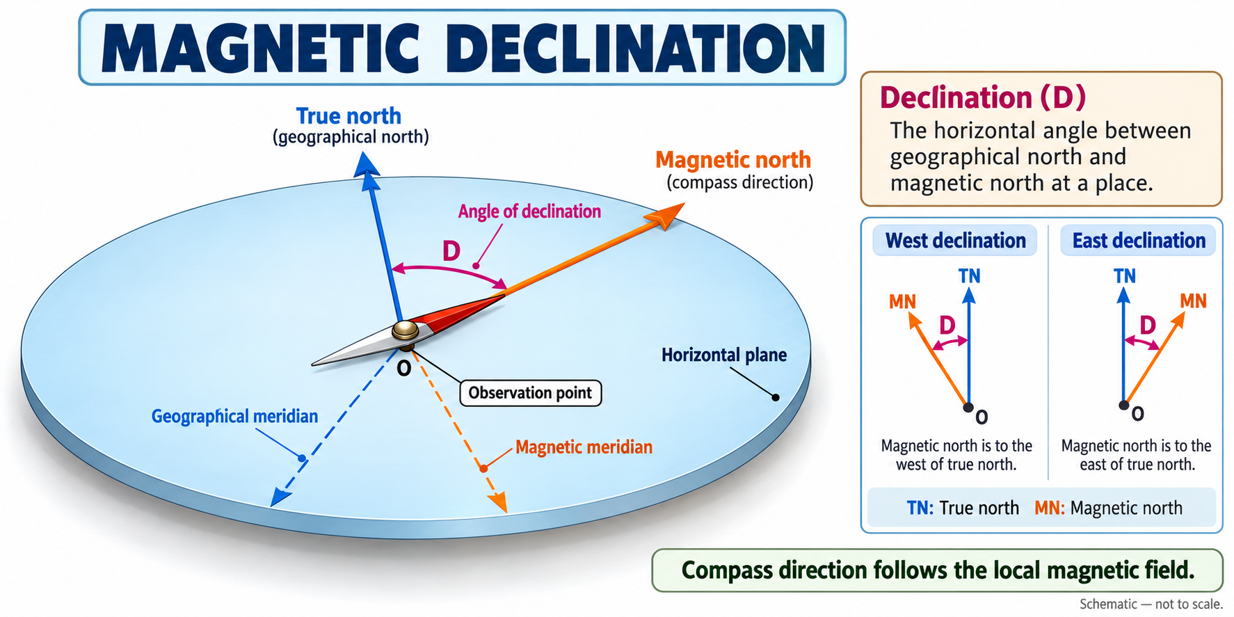
Concepts Related to Geomagnetism
Magnetic and Geographic Poles
- The Magnetic South Pole lies near the Geographical North Pole, close to Bathurst Island (Canada).
- The Magnetic North Pole lies near the Geographical South Pole, close to McMurdo Sound (Antartica).
- Hence, magnetic polarity is opposite to geographical polarity.
Magnetic vs Geographical Axis
- The Earth’s rotation axis (geographical axis) and magnetic axis do not coincide.
- The angle between them is called the Angle of Declination.
- This misalignment explains compass variation and magnetic mapping discrepancies.
Movement of Magnetic Poles
- The magnetic poles fluctuate slightly around a fixed position — a phenomenon called polar fluctuation. However, they do not migrate across large geographical distances.
- These minor positional changes reflect the dynamic nature of Earth’s magnetic field. Example: The North Magnetic Pole has shifted within the Arctic region over time but not across hemispheres.
Fluctuation in Magnetic Field Intensity
- The strength of Earth’s magnetic field varies over geological time:
At times it becomes strong, forming a stable dipolar field.
At other times, it weakens or may even temporarily disappear. - The magnetic field plays a crucial role in deflecting solar winds, X-rays, and gamma rays, shielding life on Earth.
Geomagnetism and Mass Extinctions
- Weakening or disappearance of the geomagnetic field has been correlated with major extinction phases.
- Possible reason: Loss of magnetic shielding allowed harmful cosmic radiation to reach Earth’s surface.
- Major extinctions coinciding with geomagnetic changes Ordovician Extinction Silurian Extinction
Permian Extinction (The Great Dying, ~90% of marine species vanished) Cretaceous–Tertiary (K–T) Boundary Extinction, ~65 million years ago, which led to the extinction of dinosaurs. 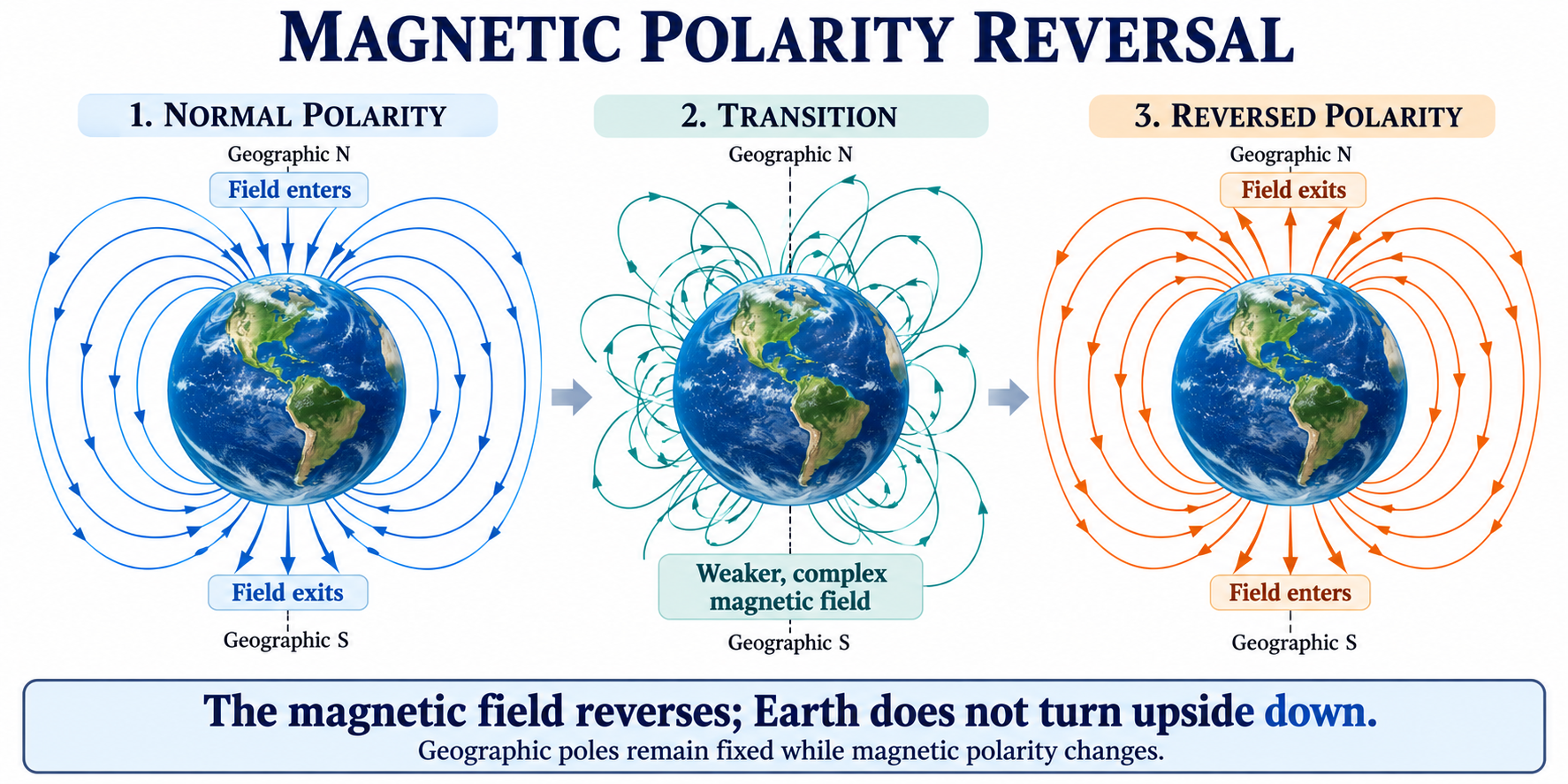
Magnetic Field Reversal (Polarity Reversal)
- Earth’s magnetic field reverses polarity at irregular intervals — i.e., North becomes South and vice versa.
- These magnetic reversals:
Have no fixed periodicity.
Are not caused by pole migration.
Occur due to weakening of the existing field and growth of opposite polarity. - The process:
The normal field gradually weakens (e.g., from −10 → −5 → 0).
Simultaneously, the reverse polarity grows (+1 → +5 → +10).
This results in a complete polarity flip. - Such reversals are recorded in paleomagnetic studies and ocean-floor basalts, forming the basis for Plate Tectonics evidence (e.g., Vine–Matthews–Morley hypothesis).
Geographical Significance
- Geomagnetism helps:
Understand continental drift and seafloor spreading.
Date igneous rock formations through magnetic chronology.
Reconstruct paleogeographic positions of continents.
Paleomagnetism
Paleomagnetism is the study of Earth’s past magnetic field preserved in rocks, sediments and archaeological materials. It helps us understand both how the magnetic field has changed and how continents have moved through geological time. While geomagnetism studies Earth’s magnetic field generally, paleomagnetism reconstructs its history from natural records. Think of certain rocks as ancient magnetic recorders: they preserve information about the magnetic field that existed when their magnetisation developed.
1. How can a rock record a magnetic field?
Some rocks contain magnetic minerals such as magnetite, hematite and titanomagnetite. Under suitable conditions, these minerals acquire magnetisation related to the surrounding magnetic field. Part of this magnetisation can remain even after the original field changes. This is called remanent magnetisation, or retained magnetism. However, a rock does not necessarily record the moment it first formed. It may acquire or replace its magnetic record during later heating or chemical alteration. There are three major ways this record develops:
| Type | How the magnetic record forms | Example |
| Thermoremanent magnetisation | Magnetic moments become stabilised as a rock cools. | Basalt produced by a volcanic eruption |
| Depositional remanent magnetisation | Magnetic particles partly align with the field during settling or shortly after deposition, before becoming fixed. | Lake and marine sediments |
| Chemical remanent magnetisation | New magnetic minerals grow during chemical changes and acquire magnetisation. | Hematite forming in red sedimentary rocks |
These processes explain why both igneous and sedimentary rocks can preserve paleomagnetic information.
2. Recording magnetism in cooling lava
This is the easiest process to understand.
- Lava erupts: It contains iron-bearing minerals or materials from which these minerals crystallise.
- The lava cools: Magnetic minerals develop stable magnetic behaviour below their Curie temperature.
- Magnetisation becomes locked: As cooling continues through blocking temperatures, the magnetic moments become sufficiently stable to retain a record of the field.
- The rock preserves the signal: Later continental movement can carry this record far from its original location.
For magnetite, the Curie temperature is approximately 580°C. However, the Curie temperature and blocking temperature are not identical: blocking depends on factors such as mineral type and grain size. The mineral grains in solid rock do not need to physically rotate like compass needles; their internal magnetic moments acquire a net orientation influenced by the field.
3. What information does paleomagnetism provide?
Three properties are particularly useful:
A. Declination: the horizontal direction
Declination is the angle between geographical north and the horizontal component of the magnetic direction. After appropriate corrections, differences between the recorded and expected directions can reveal rotation of a crustal block. Example: A rock sequence may preserve a direction that indicates its region rotated clockwise after magnetisation.
B. Inclination: the angle of magnetic dip
Inclination is the angle that the magnetic field makes with the horizontal. Under an ideal dipole field:
- At the magnetic equator, the field is horizontal: inclination is 0°.
- Towards the poles, the field becomes progressively steeper.
- At the magnetic poles, it is vertical: inclination is ±90°.
This relationship allows scientists to estimate paleolatitude, meaning the latitude where a rock acquired its magnetisation. For a geocentric axial dipole: 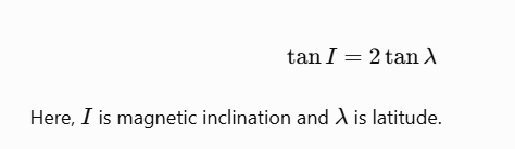
Example: An inclination of approximately 49° corresponds to a latitude of about 30° under this model. The model assumes that, when averaged over sufficient time, Earth’s field approximates a dipole aligned with its rotational axis. Paleomagnetism alone generally cannot determine absolute paleolongitude.
C. Magnetic intensity
Specialised laboratory methods can estimate the strength of the ancient magnetic field, called paleointensity. The strength of a rock’s magnetisation cannot simply be treated as field strength because it also depends on the minerals present and their properties.
4. Magnetic reversals: when polarity changes
Earth’s magnetic field has repeatedly reversed during geological history.
- Normal polarity: The field has broadly the same polarity as today.
- Reversed polarity: The field has the opposite polarity.
During a reversal, the magnetic field changes direction; Earth does not turn upside down, and its rotation does not reverse. Successive lava flows may therefore preserve alternating normal and reversed magnetisation. These records helped scientists establish a geomagnetic polarity timescale. The most recent major reversal, the Brunhes–Matuyama reversal, occurred approximately 780,000 years ago. Reversals occur at irregular intervals, rather than on a fixed schedule.
5. How paleomagnetism supported continental drift
Paleomagnetism provided a way to test continental movement using measurements preserved in rocks. Scientists examined rocks of different ages on a continent and calculated the corresponding ancient magnetic pole positions. Connecting these positions produced an Apparent Polar Wander Path (APWP). It is called apparent because the calculation initially treats the continent as stationary. A changing pole position can therefore reflect movement of the continent relative to Earth’s rotational axis. The crucial observation was that different continents produced different polar-wander paths. If all continents had remained fixed, their records should have indicated a broadly shared history of pole positions. When continents were restored towards their former positions, their paths became more consistent. This supported the conclusion that continents had moved relative to one another. It did not require assuming that all apparent polar wandering represented movement of the magnetic poles alone.
6. How paleomagnetism proved important for seafloor spreading
The ocean floor provided especially strong evidence. At a mid-ocean ridge, magma rises and forms new basaltic crust. As the basalt cools, it records the prevailing magnetic polarity. Continued crust formation moves older material away from the ridge. If the magnetic field reverses, the next generation of basalt records the opposite polarity. Repeated spreading and reversals create alternating bands of normal and reversed magnetisation, broadly parallel to the ridge and corresponding on its two sides. The analytical significance is that:
- Polarity patterns record changes in Earth’s magnetic field.
- Matching patterns across the ridge record separation of newly formed crust.
- Increasing rock ages away from the ridge establish the sequence of spreading.
The Vine–Matthews–Morley hypothesis, developed in 1963, connected magnetic reversals with seafloor spreading. It helped turn continental mobility into a measurable process. Once a magnetic band is dated, its distance from the ridge can also indicate the spreading rate. For example, 20 km of movement over one million years equals 2 cm per year on that flank. This is a half-spreading rate; the full rate measures separation between both flanks
7. Other major applications
- Reconstructing past geography: Paleolatitudes and rotations help rebuild former continental arrangements and test plate reconstructions. Indian Plate reconstructions are one application.
- Dating and correlating rock sequences: Magnetostratigraphy matches sequences of magnetic polarity with an established timescale, supported by other age information. A single normal-polarity sample cannot provide a unique age because normal polarity has occurred repeatedly.
- Understanding the geodynamo: Records of past field direction and intensity constrain how Earth’s magnetic field has behaved over time.
8. Limitations: why the record must be tested
A magnetic record is valuable only when its origin and subsequent history are understood. Heating and chemical alteration can partially or completely replace the original signal. Folding and tectonic rotation change the present orientation of magnetised rocks. Sediment compaction can flatten recorded inclinations, causing paleolatitude estimates to be too low. Scientists therefore collect oriented samples, compare multiple specimens and progressively remove less stable magnetic components in the laboratory. One useful check is the fold test: if magnetic directions become more consistent when folded beds are restored to their original orientation, the magnetisation probably predates folding. Paleomagnetism links the magnetic memory of minerals to the movement of entire continents. Its greatest geographical contribution was to provide independent, testable evidence for continental drift and seafloor spreading, helping establish plate tectonics. 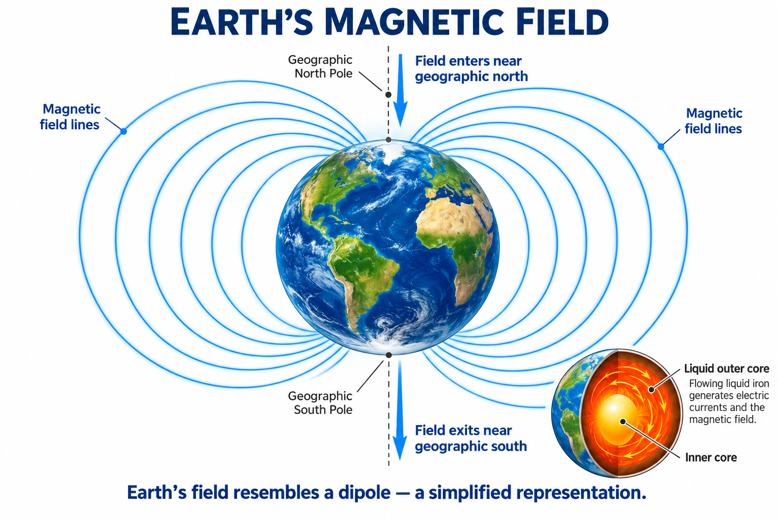
PYQs
-
Evidences from paleomagnetism and seafloor spreading have validated that continents and ocean basins have been stationary. Elucidate with suitable diagrams . (20 marks/2023)
-
Write short note on Geomagnetism and Paleomagnetism. (2011)
In case you still have your doubts, contact us on 9773890604
Enrol in Geography Optional by Shabbir Sir: Here
Enrol in One on One Personalized Mentorship: Here
Enrol in GS Mentorship Program: Here
Enrol In GS Mains Mentorship Program: Here
Explore One Integrated Platform for UPSC Prep: Yooki
Visit our YouTube Channel: here
