Contents
- 0.1 1. What is Isostasy?
- 0.2 2. Historical Background: Why Did the Concept of Isostasy Emerge?
- 0.3 3. Historical Evolution of the Concept
- 0.4 4. Major Postulates of Isostasy
- 0.5 6. Stages of Isostatic Adjustment
- 0.6 7. Major Types of Isostatic Adjustment and Their Geographical Examples
- 0.7 8. Limitations and Criticisms of the Theory of Isostasy
- 0.8 9. Significance of Isostasy in Geomorphology
- 0.9 10. Conclusion
- 1 PYQs
1. What is Isostasy?
Isostasy is the state of gravitational equilibrium in which Earth’s lithosphere is supported by the underlying denser mantle, with differences in surface elevation compensated by differences in crustal thickness, density or both. In simple language, isostasy explains why high mountains, continents and ocean basins can exist at different elevations without the Earth’s crust continuously sinking or rising. The term comes from Greek:
- Iso = Equal
- Stasis = Standing or equilibrium
The fundamental idea is that lighter materials can remain relatively elevated over denser underlying materials, just as an iceberg floats in seawater. 
Understanding isostasy through an iceberg
Imagine an iceberg floating in water.
- Only a small portion remains above the water.
- A much larger portion remains submerged.
- If extra ice is added, the iceberg sinks deeper.
- If some ice melts, it rises relative to the water surface until a new equilibrium is established.
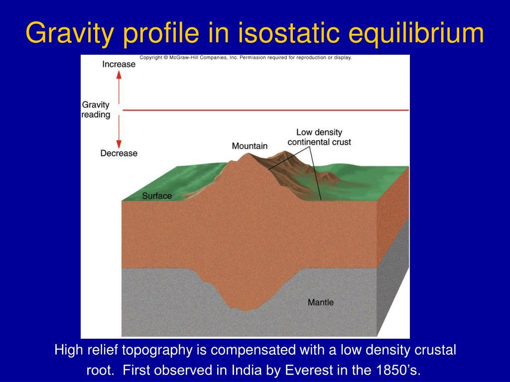
Similarly, a mountain range may have a thick crustal root extending into the mantle. However, the analogy has a limitation: Earth’s mantle is predominantly solid. It behaves like a very viscous material over geological timescales, rather than like ordinary liquid water.
Two fundamental principles
1. Archimedes’ principle of buoyancy: The pressure exerted by a buoyant body is balanced by the weight of displaced material. Isostasy applies a related principle to the lithosphere and mantle. 2. Gravitational equilibrium: At sufficient depth, the weight per unit area of neighbouring columns tends towards balance as isostatic equilibrium is approached, so high mountains do not necessarily exert much greater pressure at depth than adjoining plains because their extra surface mass may be compensated below.
2. Historical Background: Why Did the Concept of Isostasy Emerge?
The theory developed from an important scientific question: Why does the enormous mass of mountain ranges not produce the gravitational attraction expected from their visible size?
A. Initial observations: The Andes and the Himalayas
1735–1744: French Geodesic Mission in the Andes During measurements in South America, Pierre Bouguer and other scientists investigated gravitational deflection near the Andes. The observed gravitational attraction associated with the mountains was smaller than expected from their visible mass. This suggested that the mass distribution beneath mountains could be different from what had been assumed. 1840s–1850s: Himalayan observations During the Great Trigonometrical Survey of India, George Everest and surveyors associated with the survey investigated discrepancies between astronomical and geodetic measurements. In the 1850s, John Henry Pratt examined the Himalayan gravitational problem using measurements associated with stations such as Kaliana and Kalianpur. The mountains produced less gravitational deflection than calculations based on their visible mass predicted. The geographical problem: If the Himalayas possess enormous visible mass, why is their measured gravitational influence comparatively small? The answer proposed was that elevated regions must possess some form of mass deficiency beneath them, compensating for the visible mountain mass. This observation helped establish the theory of isostasy.
3. Historical Evolution of the Concept
- 1730s–1740s — Pierre Bouguer Gravitational measurements associated with the Andes revealed discrepancies between observed and theoretically expected attraction.
2. 1855 — George Biddell Airy Explained elevated mountains through a thick, low-density crust with deep roots extending into the denser mantle. 3.1855 — John Henry Pratt Proposed that topographic differences could arise from lateral variations in the density of material above a common compensation depth. 4. 1889 — Clarence Dutton Popularised the term isostasy to describe gravitational balance within Earth’s outer layers. 5. Early 20th century — Hayford and Heiskanen Developed mathematical and geodetic models of isostatic compensation, helping quantify crustal mass distributions. 6. 20th century — Vening Meinesz and subsequent researchers Developed the concept of regional compensation through lithospheric bending, laying foundations for flexural isostasy. 7. Modern period — Seismology, GPS and satellite gravimetry Measurements of crustal thickness, land uplift and gravity changes provide evidence for isostatic adjustments. Key transformation: Isostasy evolved from an explanation of gravity anomalies into a fundamental principle for understanding mountain roots, crustal deformation, glacial rebound, sedimentary basins and vertical land movement.
4. Major Postulates of Isostasy
The classical concept is based on the following assumptions.
- Density contrast between crust and mantle: The Earth’s crust is generally less dense than the underlying mantle.
Typical approximate values:
| Material | Density |
| Continental crust | 2.7 g/cm³ |
| Oceanic crust | 2.9–3.0 g/cm³ |
| Upper mantle | 3.3 g/cm³ |
These differences enable buoyant support.
- Gravitational balance: Neighbouring lithospheric columns tend to have approximately equal weights per unit area at an appropriate compensation depth when the region is in equilibrium.
- Compensation of topographic relief: Mountains, plateaus and basins may possess compensating subsurface structures. For example, a high mountain can be supported by a deep crustal root.
- Vertical adjustment: Addition or removal of surface mass can cause subsidence or uplift as the lithosphere and mantle respond.
- Depth of compensation: Classical models assume that topographic mass differences are balanced at or above a specified depth, often called the depth of compensation.
- Dynamic adjustment: Isostasy is not necessarily permanent or instantaneous. Tectonic uplift, erosion, sediment deposition and glaciation continuously disturb equilibrium, producing new adjustments. Important distinction: Equal crustal thickness and uniform rock density are not universal postulates of isostasy. They are simplifying assumptions used differently in Airy’s and Pratt’s models.
7. Major Theories or Models of Isostasy: Three major approaches help explain how isostatic compensation operates.
A. Airy’s Theory of Isostasy (1855)
Central idea: Uniform density but variable crustal thickness. According to Airy:
- The crust has approximately uniform density.
- Mountains possess thicker crust and deeper roots.
- Plains possess comparatively thinner crust.
- Higher mountains generally require deeper compensating roots.
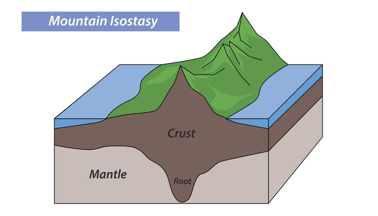 Example: Himalayas and Tibetan Plateau The Himalayas and Tibetan Plateau have exceptionally thick crust, commonly around 60–75 km in substantial portions of the region, compared with typical continental crust of approximately 30–40 km. This supports the importance of crustal thickening and Airy-type compensation, although tectonic forces also play a major role.
Mathematical explanation
In the simple Airy model: 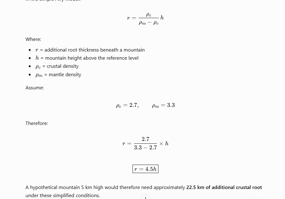 Airy Model: Calculate the Root Interactive Adjust mountain height and observe the corresponding root thickness using the assumed densities above.
 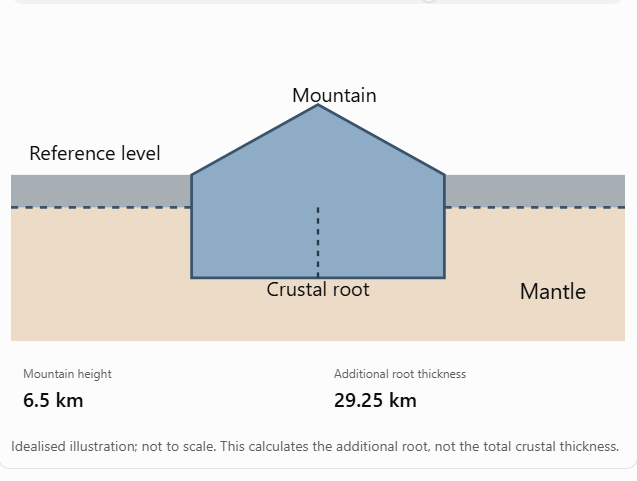 Significance: Airy’s theory explains the association between elevated mountain ranges and thickened continental crust. Limitation: Not every mountain or plateau is supported entirely by deep crustal roots. Thermal buoyancy, density variations, flexure and tectonic stresses also contribute.
B. Pratt’s Theory of Isostasy (1855)
Central idea: Variable density but a common compensation depth. According to Pratt:
- Differences in surface elevation arise from differences in the average density of vertical columns.
- Higher regions possess comparatively lower-density material.
- Lower regions possess relatively higher-density material.
- The columns extend to a common compensation level.
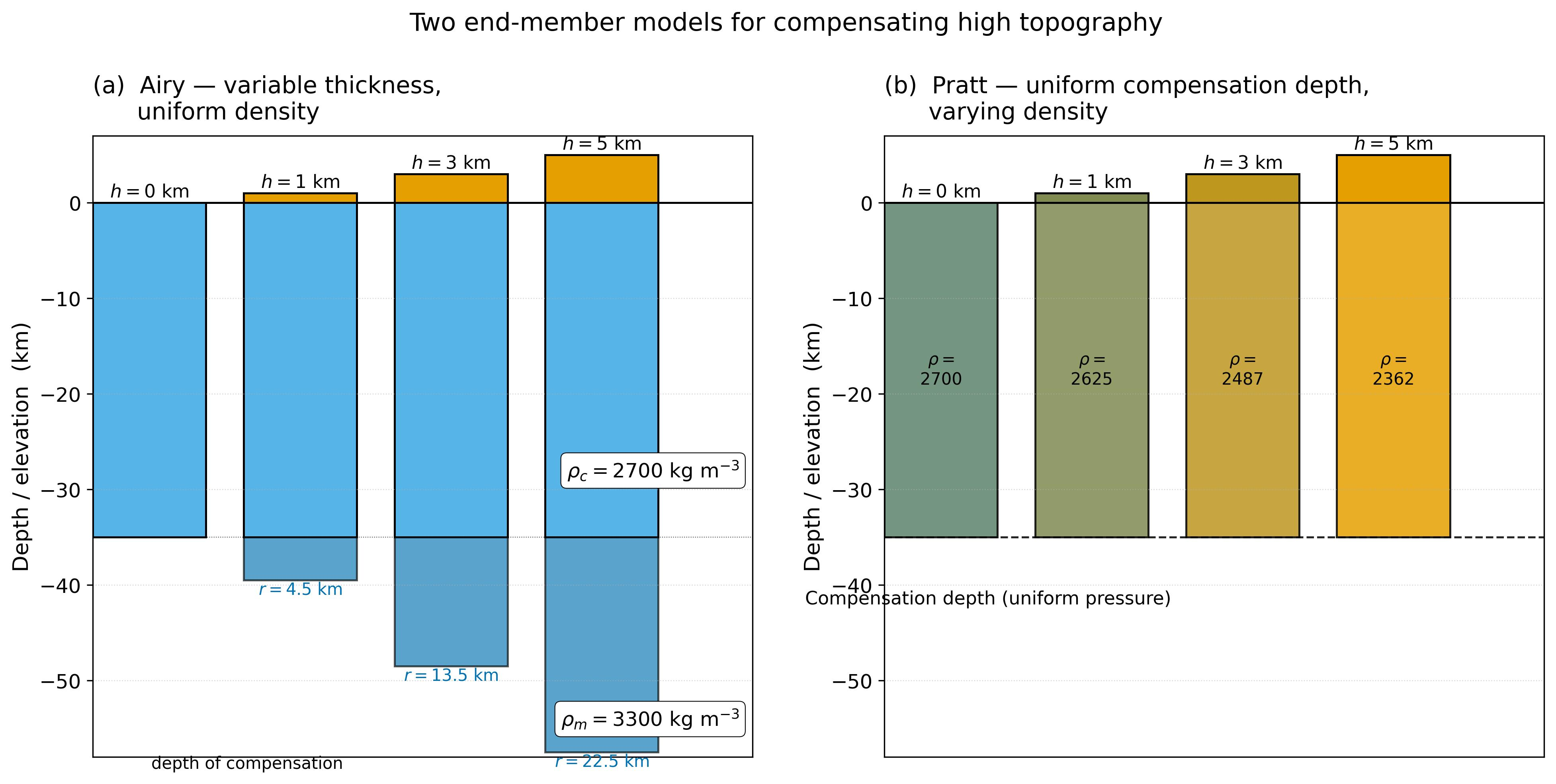 Simple example: Imagine two equal-area columns of different heights above a common basal level. The taller column must possess a lower average density to exert the same pressure at its base. Under equal column weight:
  Geographical example: Elevated regions produced partly by thermal expansion of mantle material illustrate Pratt-like density compensation. Hotter, less-dense mantle can contribute to regional surface uplift. Limitation: The assumption of uniform density within each column and a common basal compensation level is highly simplified and does not adequately explain many observed crustal roots.
C. Flexural Isostasy: Vening Meinesz Model
Central idea: The lithosphere behaves as an elastic or viscoelastic plate, distributing surface loads across a wider region. Unlike the simple Airy model, where compensation occurs directly beneath a mountain, flexural isostasy recognises regional load sharing. A large load causes the lithosphere to bend, producing subsidence beneath the load and sometimes uplift around its margins. 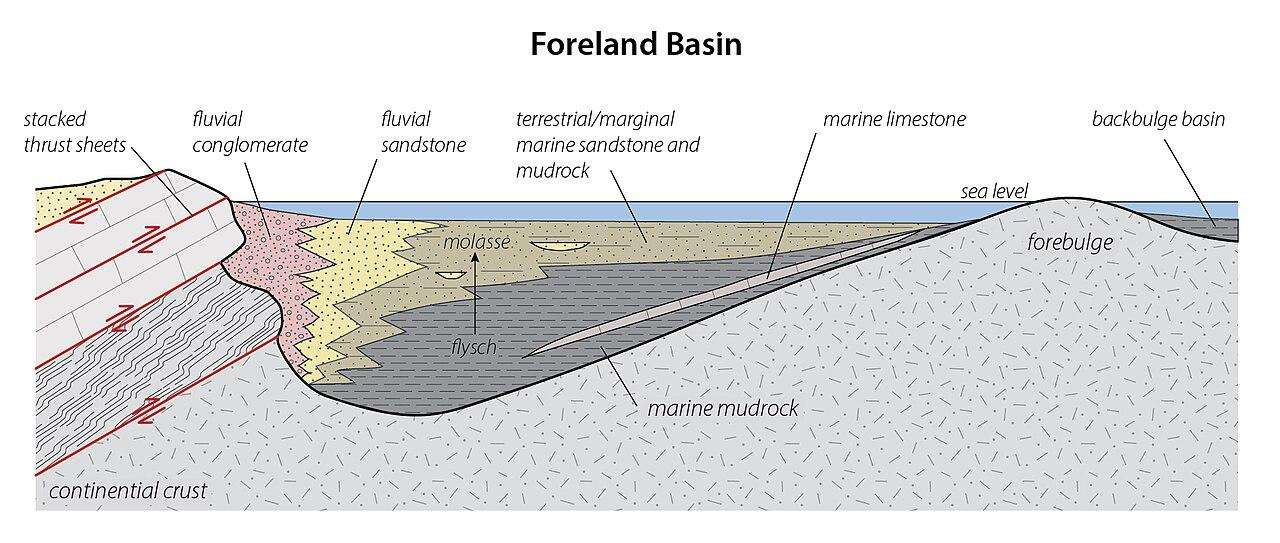 Examples:
- The Indo-Gangetic foreland basin is associated with lithospheric flexure caused by the Himalayan orogenic load and related tectonic processes.
- The Hawaiian Islands create volcanic loads that bend the Pacific lithosphere and help form adjacent depressions.
The flexural approach explains why loading and compensation may extend far beyond the location of the surface mass.
Comparative Understanding
| Basis | Airy | Pratt | Flexural |
| Principal control | Crustal thickness | Density variation | Lithospheric bending |
| Compensation | Local | Idealised local columns | Regional |
| Crustal roots | Fundamental | Not required | May contribute |
| Example | Himalayas | Thermally elevated regions | Hawaiian Islands |
Geographical inference: These models are not necessarily mutually exclusive. Real landscapes may be supported through a combination of crustal thickening, density contrasts and lithospheric flexure. The USGS likewise notes that no single simple isostatic model adequately represents all geological provinces.
6. Stages of Isostatic Adjustment
One important clarification: Isostasy itself does not have fixed universal stages. However, the process through which the lithosphere responds to loading and unloading can be explained in four stages.
Stage 1: Initial Isostatic Equilibrium
Before any major change in surface loading, the lithosphere is approximately balanced. For example, a continental region may remain at a relatively stable elevation because its weight is balanced by buoyant support from below.
Stage 2: Disturbance of Equilibrium
The balance is disturbed when a surface load is added or removed. Major causes include:
- Accumulation or melting of continental glaciers.
- Mountain building through tectonic convergence.
- Erosion and removal of large quantities of rock.
- Deposition of sediments in large basins.
- Formation of volcanic islands and seamounts.
Example: During the Pleistocene glaciations, thick ice sheets accumulated over Scandinavia and Canada, substantially increasing the weight imposed on the lithosphere.
Stage 3: Isostatic Adjustment
The lithosphere begins responding to the changed load. When loading increases: The lithosphere tends to subside and mantle material is displaced. When loading decreases: The lithosphere tends to rebound upward as mantle material redistributes. This response may include both relatively rapid elastic deformation and slow viscous mantle flow.
Stage 4: Attainment of a New Equilibrium
Over time, the lithosphere approaches a new balance. However, adjustment can continue for thousands of years, and changing tectonic or climatic conditions may prevent full equilibrium from being attained. 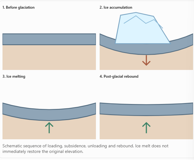
7. Major Types of Isostatic Adjustment and Their Geographical Examples
A. Glacial Isostasy
 Example: Scandinavia and the Baltic region Thick ice sheets depressed northern Europe during the last glacial period. After deglaciation, unloading initiated crustal rebound. Portions of Scandinavia continue to rise today, even though the large continental ice sheets disappeared thousands of years ago. GPS and satellite gravity measurements independently support the process. Geomorphological significance: Post-glacial rebound produces raised shorelines, changes relative sea level and modifies coastal drainage.
B. Erosional Isostasy
When erosion removes rock from elevated terrain, the load on the crust decreases, allowing the region to rise isostatically. Example: Himalayas Rivers such as the Ganga’s Himalayan tributaries and the Brahmaputra transport large quantities of sediments away from the mountain system. The removal of rock contributes to isostatic rebound. However, Himalayan elevation is also influenced by ongoing India–Eurasia convergence, faulting and crustal shortening. Important relationship: Erosion → Reduction of crustal load → Isostatic uplift → Exposure of deeper rocks. Thus, erosion may lower a mountain’s surface while simultaneously generating rock uplift, partially offsetting the loss of elevation.
C. Sedimentary Isostasy
Sediment accumulation increases the load on the lithosphere, which may respond through subsidence. Example: Ganga–Brahmaputra foreland and deltaic regions Sediments supplied from the Himalayas accumulate in the foreland basin and Bengal Basin. Sedimentary loading contributes to subsidence, alongside tectonic flexure, sediment compaction and other processes. This creates accommodation space for further sediment deposition. The relationship can become a feedback mechanism: Sediment deposition → Additional loading → Subsidence → More space for deposition.
D. Volcanic Load Isostasy
Large volcanic edifices impose additional loads on oceanic lithosphere. Example: Hawaiian Islands The accumulation of volcanic material bends the Pacific lithosphere and contributes to surrounding subsidence. Here, regional flexure explains the deformation more effectively than simple local Airy compensation.
E. Tectonic Isostasy
Changes in crustal thickness and lithospheric structure during mountain building modify buoyancy. Example: Tibetan Plateau Continental collision thickens crust and produces elevated terrain. Buoyant support helps maintain the plateau’s great height. Nevertheless, isostasy does not by itself explain the forces responsible for collision. Those forces arise from plate tectonics.
8. Limitations and Criticisms of the Theory of Isostasy
Although isostasy is a fundamental geophysical principle, its classical models are based on simplified assumptions. 1. Overemphasis on vertical equilibrium Airy’s and Pratt’s models mainly describe vertical mass compensation. They inadequately incorporate horizontal tectonic forces and complex lithospheric stresses. Example: Himalayan uplift cannot be explained without India–Eurasia plate convergence. 2. Assumption of uniform crustal density Airy assumes approximately uniform crustal density, while Pratt simplifies lateral density differences. In reality, crustal density varies with lithology, temperature, composition and metamorphism. Example: Granite-rich continental crust and denser mafic crust possess different densities. 3. Neglect of lithospheric strength Classical local-compensation models do not fully account for the strength and bending of the lithosphere. Example: Hawaiian volcanic loads cause regional lithospheric flexure, rather than purely local compensation. 4. Isostatic equilibrium is not universal Certain tectonically active regions remain far from equilibrium because of continuing deformation. Example: Subduction zones experience strong bending, faulting and forces from descending plates. 5. Inability to explain the origin of mountain building Isostasy explains the buoyant support and readjustment of elevated terrain, but it does not independently explain how mountains form. Example: The Himalayas originated through continental convergence; isostatic compensation helps explain their crustal support. 6. Adjustment takes geological time Classical static descriptions do not fully capture the time-dependent viscosity of the mantle. Example: Parts of northern Europe and Canada continue adjusting to the disappearance of Pleistocene ice sheets. 7. Influence of dynamic topography Mantle convection can support or depress the surface independently of classical local isostatic compensation. This means surface elevation may depend on both buoyancy and stresses associated with mantle flow. Critical observation: Modern geophysics has not rejected isostasy. Instead, it has expanded the classical concept by incorporating lithospheric flexure, mantle rheology, tectonics and time-dependent adjustment.
9. Significance of Isostasy in Geomorphology
Isostasy connects endogenic processes (tectonics and crustal movements) with exogenic processes (erosion, deposition and glaciation).
| Geographical process | Significance of isostasy |
| Mountain evolution | Explains crustal roots and uplift associated with erosion |
| Glaciation | Explains subsidence under ice and rebound after melting |
| River-basin development | Helps explain crustal response to sediment accumulation |
| Coastal geomorphology | Influences relative sea-level change and raised beaches |
| Volcanic island formation | Explains lithospheric bending under volcanic loads |
| Plate tectonics | Helps explain buoyant support and crustal thickening |
A useful Indian geographical example: The Himalayas–Ganga Plain Syste em
10. Conclusion
The concept of isostasy, pioneered through the models of Airy and Pratt, provides a fundamental explanation for the gravitational balance and vertical adjustment of Earth’s lithosphere. Although classical theories cannot independently explain every mountain range, basin or crustal movement, modern flexural and dynamic models have substantially strengthened the concept. The central geographical insight is that Earth’s surface is not static: it continuously responds to changing loads, tectonic forces and mantle processes in its tendency towards gravitational equilibrium. 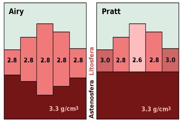 Plate tectonics primarily explains the forces responsible for mountain building; isostasy explains how crustal masses are supported and how they readjust when their loads change.
PYQs
- The concept of Plate tectonics has been derived from the isostasy and continental drift Elaborate citing suitable examples. (20 Marks/2021)
- Explain the concept of isostasy as postulated by Airy and Pratt. (2011)
- Define the concept of isostasy and discuss the postulations of Airy and Pratt. (2007)
- Present a critical analysis of the theory of Isostacy. (2001)
In case you still have your doubts, contact us on 9773890604
Enrol in Geography Optional by Shabbir Sir: Here Enrol in One on One Personalized Mentorship: Here Enrol in GS Mentorship Program: Here Enrol In GS Mains Mentorship Program: Here Explore One Integrated Platform for UPSC Prep: Yooki Visit our YouTube Channel: here
