
Contents
- 1 C.W. Thornthwaite’s Climatic Classification
- 1.1 A. Thornthwaite’s 1931 Classification: The Concept of Precipitation Effectiveness
- 1.2 Precipitation Efficiency Index (PEI)
- 1.3 Thermal Efficiency Index (TEI)
- 1.4 B. Thornthwaite’s 1948 Classification: The Concept of Potential Evapotranspiration (PET)
- 1.5 Potential Evapotranspiration (PET): The Central Innovation
- 1.6 Moisture Index (Im)
- 1.7 C. Applications and Analysis
- 2 G.T. Trewartha’s Climatic Classification
- 3 Concept
- 4 Philosophy: Geography as the Study of Areal Differentiation
- 5 A Balanced Approach
- 6 Key Features
C.W. Thornthwaite’s Climatic Classification
The limitations of Köppen’s Climatic Classification, particularly its emphasis on broad climatic patterns and its inability to adequately explain the availability of moisture for vegetation and human activities, encouraged climatologists to develop more application-oriented classification systems. While Köppen successfully demonstrated that vegetation reflects climate, he assumed that the total amount of rainfall received by a region was sufficient to explain vegetation distribution. C.W. Thornthwaite challenged this assumption by arguing that all rainfall is not equally effective. A considerable proportion of precipitation is lost through evaporation, transpiration, surface runoff, and infiltration, meaning that only a part of the received rainfall is actually available for sustaining vegetation and human activities. Consequently, he proposed a more scientific and quantitative approach that measured the effective availability of moisture rather than simply the amount of rainfall received. This marked an important shift in climatology—from describing climatic conditions to evaluating their functional significance, particularly for agriculture, water resource management, and ecological studies.
A. Thornthwaite’s 1931 Classification: The Concept of Precipitation Effectiveness
Thornthwaite’s 1931 climatic classification was built upon the fundamental idea that natural vegetation responds not to total precipitation but to effective precipitation. In other words, the ecological impact of rainfall depends not only on how much rain falls but also on how much of that rainfall remains available after atmospheric and surface losses. For example, two regions may receive the same annual rainfall, yet one may support dense forests while the other remains comparatively dry because higher temperatures increase evaporation losses. Therefore, rainfall must always be interpreted together with temperature and evaporation if the true moisture status of a region is to be understood. This concept represented a major refinement of Köppen’s original philosophy.
Precipitation Efficiency Index (PEI)
To quantify the effectiveness of rainfall, Thornthwaite introduced the Precipitation Efficiency Index (PEI), also known as the Precipitation Effectiveness Index (PE). Instead of considering rainfall alone, this index relates precipitation to evaporation, thereby estimating the amount of moisture that is actually available for plant growth. 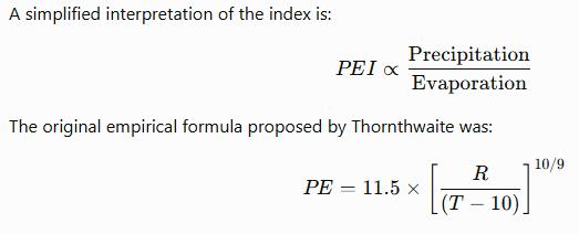 where:
- R = Annual Rainfall (in inches)
- T = Mean Annual Temperature (°F)
Although the mathematical expression appears complex, its geographical interpretation is straightforward.
- Higher rainfall increases precipitation effectiveness.
- Higher temperatures increase evaporation, thereby reducing the effective availability of moisture.
Thus, PEI measures the usable moisture available within a climatic region rather than total rainfall.
Conceptual Significance
This represented one of the earliest attempts to integrate water balance into climatic classification. Instead of asking, “How much rainfall does a region receive?” Thornthwaite asked, “How much of that rainfall is actually available for sustaining vegetation?” This conceptual shift greatly enhanced the practical usefulness of climatic classification. This diagram clearly illustrates why Thornthwaite regarded effective precipitation, rather than total precipitation, as the true determinant of vegetation. 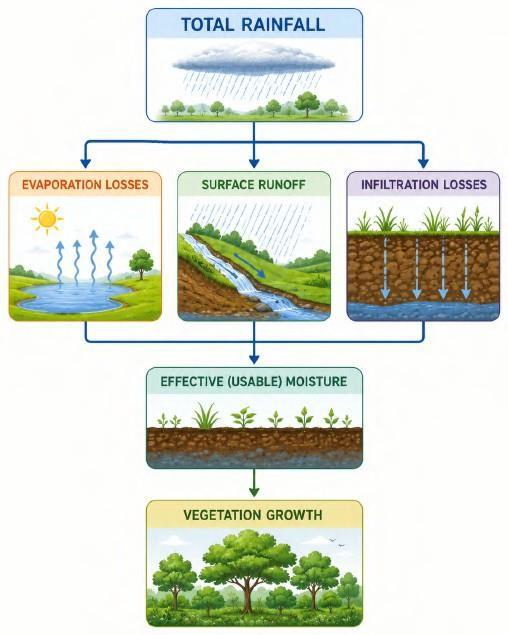
Thermal Efficiency Index (TEI)
Recognising that moisture availability alone could not completely explain climatic differences, Thornthwaite introduced another important parameter—the Thermal Efficiency Index (TEI). The Thermal Efficiency Index measures the thermal energy available within a climatic region. 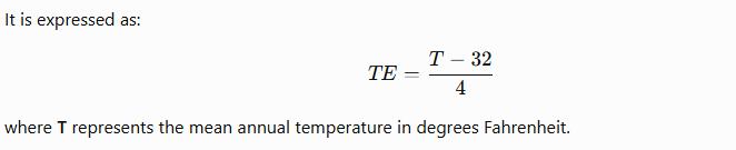 Unlike Köppen, who used fixed temperature boundaries, Thornthwaite attempted to quantify the actual thermal effectiveness experienced by plants and ecosystems. Temperature thus became an indicator of available heat energy rather than merely a numerical climatic threshold.
Humidity Provinces
Using the Precipitation Efficiency Index, Thornthwaite divided the world into Humidity Provinces, representing different degrees of moisture availability. These ranged from:
- A — Rainforest Province (highest moisture availability)
- B
- C
- D
- E — Desert Province (lowest moisture availability)
Regions possessing very high PEI values (A ≥ 127) receive abundant effective rainfall and therefore support dense evergreen vegetation. 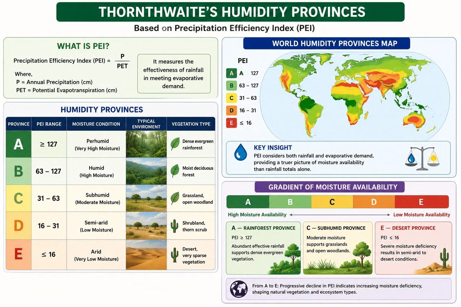 Conversely, progressively declining PEI values indicate increasing moisture deficiency, eventually producing semi-arid and desert environments. Rather than relying upon rainfall totals alone, this classification reflects the actual ecological effectiveness of available moisture.
Thermal Provinces
Similarly, Thornthwaite classified the world into six Thermal Provinces using the Thermal Efficiency Index. These include:
- A′ — Tropical
- B′ — Mesothermal
- C′ — Microthermal
- D′
- E′
- F′ — Frigid
These provinces represent a gradual decline in available thermal energy from the Equatorial regions towards the Polar areas. Unlike Köppen’s rigid temperature limits, Thornthwaite’s thermal provinces attempt to represent the functional role of heat in supporting vegetation and ecological processes. 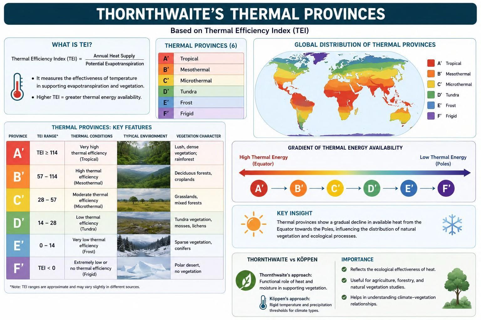 Thornthwaite’s 1931 classification represents a significant advance in climatology because it shifted attention from raw climatic observations to the functional effectiveness of climatic elements. By introducing the concepts of effective precipitation and thermal efficiency, he recognised that ecosystems respond not simply to the quantity of rainfall or temperature, but to the amount of usable moisture and available heat. This made his classification considerably more relevant for agricultural planning, hydrology, ecological studies, and environmental management, while laying the foundation for later developments in climatic water-balance analysis.
 B. Thornthwaite’s 1948 Classification: The Concept of Potential Evapotranspiration (PET)
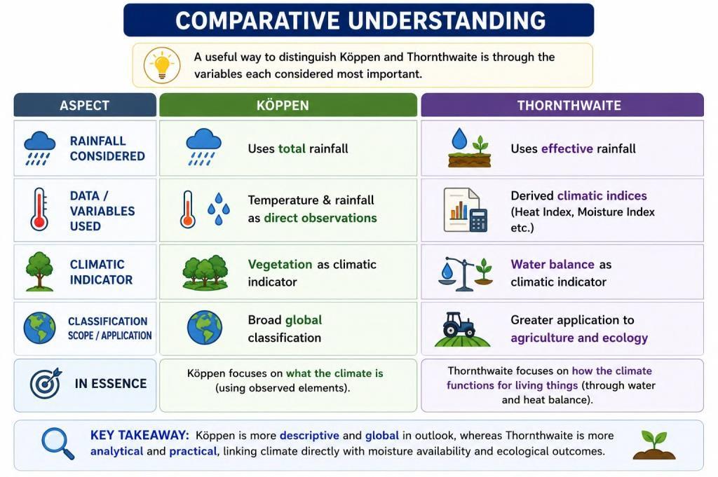
Although Thornthwaite’s 1931 classification represented a significant improvement over Köppen’s system by introducing the concept of effective precipitation, climatological research soon revealed that even this approach did not fully capture the complex relationship between climate and water availability. The earlier classification primarily considered the moisture actually retained after climatic losses, but it did not adequately account for the atmospheric demand for water under different environmental conditions. Recognising this limitation, Thornthwaite proposed a substantially revised classification in 1948, introducing the concept of Potential Evapotranspiration (PET). This marked a major shift in climatology, as the focus moved from measuring actual moisture losses to estimating the maximum amount of water that could be lost if an unlimited supply of moisture were available. Consequently, the 1948 system became one of the earliest climatic classifications to incorporate the concept of the water balance, making it far more useful for agriculture, hydrology, and environmental planning.
Potential Evapotranspiration (PET): The Central Innovation
The cornerstone of Thornthwaite’s revised classification is the concept of Potential Evapotranspiration (PET). Potential Evapotranspiration represents the amount of water that would be lost through evaporation from the soil and transpiration from plants if sufficient moisture were continuously available. Unlike actual evapotranspiration, which depends upon the existing water content of the soil, PET measures the atmosphere’s capacity to remove water under ideal moisture conditions. In simple terms, Actual Evapotranspiration = What is lost under existing soil moisture conditions. Potential Evapotranspiration = What could be lost if the soil remained completely saturated. This distinction is extremely important because climatic dryness is not determined solely by the amount of rainfall received. It also depends upon how great the atmospheric demand for water is. For example, two regions may receive identical annual rainfall, yet the hotter region will experience greater PET and therefore greater moisture stress. Thus, Thornthwaite shifted the focus from rainfall alone to the balance between water supply and atmospheric water demand.
Moisture Index (Im)
To integrate both water surplus and water deficit into a single climatic measure, Thornthwaite introduced the Moisture Index (Im). Instead of relying only on precipitation, the Moisture Index evaluates the overall water balance of a region. 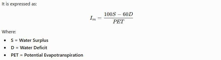 This composite index indicates whether a region possesses an excess or deficiency of moisture relative to the atmospheric demand. Positive values indicate humid climates, where as increasingly negative values represent progressively drier climatic conditions.
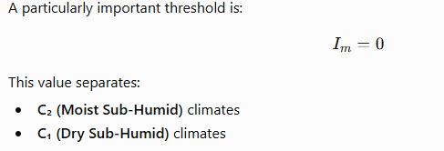 Thus, the Moisture Index provides a quantitative basis for distinguishing climatic regions according to their effective moisture availability rather than rainfall totals alone.
C. Applications and Analysis
The introduction of Potential Evapotranspiration and the Moisture Index transformed Thornthwaite’s classification from a broad climatic framework into a highly practical tool for environmental planning and resource management. Unlike Köppen’s system, which primarily serves as a global climatic classification, Thornthwaite’s approach is designed to evaluate the functional relationship between climate, water availability, soils, and vegetation at much finer spatial scales.
Merits
One of the greatest strengths of Thornthwaite’s classification lies in its scientific precision. By incorporating derived climatic indices such as PET and the Moisture Index, the classification provides a much more realistic representation of environmental conditions than systems based solely on temperature and rainfall. Another important advantage is its ability to classify climate at district, watershed, or even farm level. This makes the system particularly valuable for local planning, where relatively small climatic variations can significantly influence agriculture, irrigation, and land use. Consequently, Thornthwaite’s classification is regarded as one of the most mathematically rigorous and application-oriented climatic classification systems.
Applications
The practical utility of Thornthwaite’s classification has led to its widespread adoption in several specialised fields. Indian Council of Agricultural Research (ICAR) In India, the Indian Council of Agricultural Research (ICAR) employs the Moisture Index to identify drought-prone regions.  generally correspond to regions receiving approximately 100 cm of annual rainfall under Indian climatic conditions and are recognised as particularly vulnerable to moisture stress. Such information assists agricultural planners in selecting suitable cropping patterns, irrigation strategies, and drought mitigation measures. National Bureau of Soil Survey and Land Use Planning (NBSS&LUP): The National Bureau of Soil Survey and Land Use Planning (NBSS&LUP) also utilises Thornthwaite’s indices extensively. The classification assists in:
- Soil moisture assessment,
- Salinity management,
- Leaching studies,
- Land capability evaluation,
- Watershed planning,
- Sustainable land-use management.
By integrating climatic water balance with soil characteristics, the system provides an effective scientific basis for long-term environmental planning.
Limitations
Despite its scientific sophistication, Thornthwaite’s classification also possesses certain limitations. The greatest drawback is its mathematical complexity. Unlike Köppen’s concise alphabetical symbols, Thornthwaite’s classification depends upon several derived indices and calculations that require extensive climatic data. Consequently, it is considerably more difficult to understand, compute, and apply without detailed meteorological records. Another limitation concerns its cartographic representation. 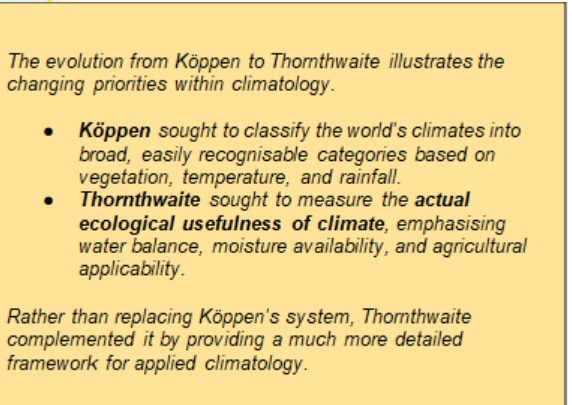 Because the classification incorporates numerous quantitative variables and local climatic differences, it cannot be easily represented on a single world climatic map. Instead, it is better suited to regional, district, or watershed-level analysis. Thus, while Köppen provides an excellent framework for understanding global climatic diversity, Thornthwaite excels in local climatic planning and environmental management. Thornthwaite’s 1948 classification represents one of the most significant advances in modern climatology because it introduced the concept of atmospheric water demand into climatic analysis. By using Potential Evapotranspiration and the Moisture Index, climate was interpreted not merely as a combination of temperature and rainfall but as a dynamic balance between water supply and water requirement. This transformed climatic classification into an indispensable tool for agriculture, hydrology, soil conservation, watershed management, and regional planning, firmly establishing Thornthwaite’s system as one of the foundations of applied climatology.
G.T. Trewartha’s Climatic Classification
The progression from Köppen to Thornthwaite reflects the gradual evolution of climatology from a largely descriptive discipline to a highly quantitative and application-oriented science. While Thornthwaite significantly improved climatic analysis by incorporating Potential Evapotranspiration, Moisture Indices, and Water Balance, the increasing mathematical complexity of his system also created new challenges. Although scientifically rigorous, the classification became difficult to represent on a global map and was less convenient for broad geographical interpretation. Recognising the need for a balanced approach, Glenn Thomas Trewartha proposed a modified climatic classification that sought to combine the clarity and global applicability of Köppen’s system with the conceptual improvements introduced by Thornthwaite. Rather than replacing earlier classifications, Trewartha attempted to refine them by making climatic regions both scientifically meaningful and geographically interpretable.
Concept
Trewartha’s classification represents a middle path between the two dominant approaches that preceded it. On one hand, it retained the simplicity, clarity, and cartographic convenience of Köppen’s climatic regions. On the other, it recognised that certain refinements were necessary to better represent the actual climatic diversity observed across the Earth’s surface. Instead of introducing highly mathematical indices, Trewartha modified the climatic boundaries wherever empirical evidence suggested that Köppen’s original categories required improvement. His objective was therefore not to create an entirely new climatic classification but to produce a more realistic geographical interpretation of the world’s climatic regions.
Philosophy: Geography as the Study of Areal Differentiation
The intellectual foundation of Trewartha’s classification lies in the geographical concept of Areal Differentiation. According to this perspective, the primary objective of geography is to understand how and why different regions of the Earth differ from one another. Climate, therefore, should not merely be analysed through numerical indices; it should also be capable of explaining the spatial organisation of landscapes, vegetation, agriculture, and human activities. Trewartha believed that climatic classification should remain descriptive and geographical, allowing geographers to recognise and map regional climatic variations without becoming excessively dependent upon mathematical calculations. Thus, his classification was designed to preserve the geographical character of climatology while incorporating scientific refinements wherever necessary.
A Balanced Approach
One of the most important characteristics of Trewartha’s classification is its balanced methodology. Unlike Thornthwaite, who relied extensively upon derived climatic indices and complex calculations, Trewartha deliberately avoided excessive mathematical sophistication. He recognised that quantitative methods undoubtedly improve scientific precision, but an overemphasis on mathematical modelling can sometimes obscure the broader geographical patterns that climatology seeks to explain. Consequently, his classification attempts to integrate causal understanding wherever possible while retaining the descriptive clarity required for geographical analysis. This balanced perspective enabled Trewartha’s system to remain both scientifically credible and educationally accessible.
Key Features
Retention of Global Climatic Mapping
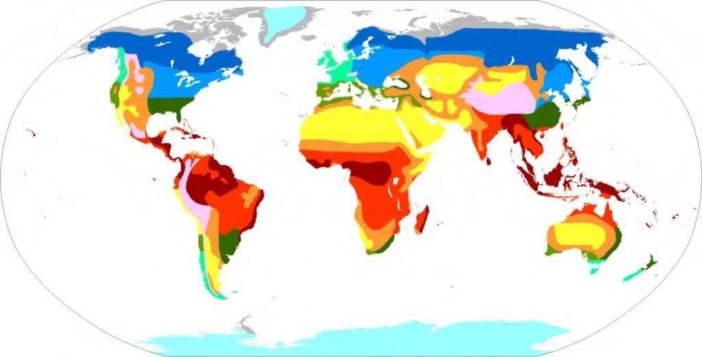 One of the principal advantages of Trewartha’s classification is that it retains the cartographic simplicity of Köppen’s system. The climatic regions can be represented effectively on world climatic maps, making the classification particularly useful for regional comparison and geographical interpretation. Unlike Thornthwaite’s highly detailed climatic indices, which are best applied at district or watershed scales, Trewartha’s climatic regions remain easily recognisable at the continental and global levels.
Incorporation of Climatic Causes
Although primarily descriptive, Trewartha recognised the importance of understanding the physical causes responsible for climatic differences. Wherever possible, the classification considers factors such as:
- Atmospheric circulation,
- Air masses,
- Continentality,
- Relief,
- Latitude,
- Oceanic influence.
However, these causal factors are incorporated only to the extent that they enhance geographical understanding without compromising the simplicity of the classification.
Avoidance of Excessive Quantification
During the mid-twentieth century, geography experienced the Quantitative Revolution (QR), characterised by an increasing emphasis on statistical methods, mathematical modelling, and numerical analysis. While acknowledging the scientific value of quantitative techniques, Trewartha cautioned against reducing geography to purely mathematical exercises. He argued that the discipline must continue to emphasise regional differentiation, spatial interpretation, and environmental relationships rather than becoming dominated by complex numerical models. Consequently, his climatic classification deliberately avoided the excessive mathematical complexity associated with some later climatic systems.
An Advocate of Köppen
Trewartha’s work is often described as an extension rather than a rejection of Köppen’s classification. He accepted that Köppen had established one of the most successful climatic classification systems ever developed. His contribution lay in refining climatic boundaries, improving regional representation, and correcting certain anomalies without disturbing the overall structure of Köppen’s original framework. For this reason, Trewartha is frequently regarded as a geographical advocate of Köppen, seeking to preserve its strengths while reducing its limitations. 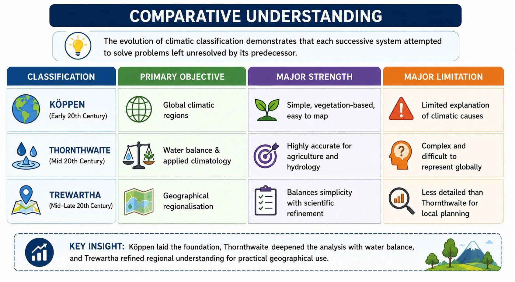 Trewartha’s classification represents an important attempt to reconcile scientific precision with geographical interpretation. Rather than viewing climatology as either a purely descriptive exercise or a purely mathematical discipline, it emphasises that climatic classification should ultimately enhance our understanding of the spatial organisation of the Earth’s environments. By refining Köppen’s broad climatic regions while avoiding excessive quantitative complexity, Trewartha preserved the essential geographical purpose of climatic classification—namely, to explain the distribution of climatic regions and their influence on landscapes, ecosystems, and human life.
Summary of the Climatic Classification Debate
The evolution of climatic classification reflects the continuous effort of climatologists to develop a system that is both scientifically accurate and geographically meaningful. Each successive classification emerged not because the previous one was entirely incorrect, but because it addressed specific limitations while responding to the changing needs of geographical research. Köppen established the first universally accepted climatic classification by organising the world’s climates on the basis of observable temperature, rainfall, and natural vegetation. Its greatest strength lay in its simplicity, objectivity, and ability to represent climatic regions clearly on a global map. However, its empirical nature meant that it described climatic conditions without adequately explaining the physical processes responsible for them or addressing local planning requirements. Seeking to overcome these limitations, C.W. Thornthwaite shifted the focus from climatic description to climatic effectiveness. Through concepts such as Potential Evapotranspiration (PET) and the Moisture Index, he introduced the idea that climate should be evaluated in terms of water balance and environmental utility rather than raw meteorological observations. This made his classification exceptionally valuable for agriculture, hydrology, soil conservation, and resource planning. Nevertheless, its mathematical sophistication limited its usefulness as a broad geographical classification and made it difficult to depict on a world map. 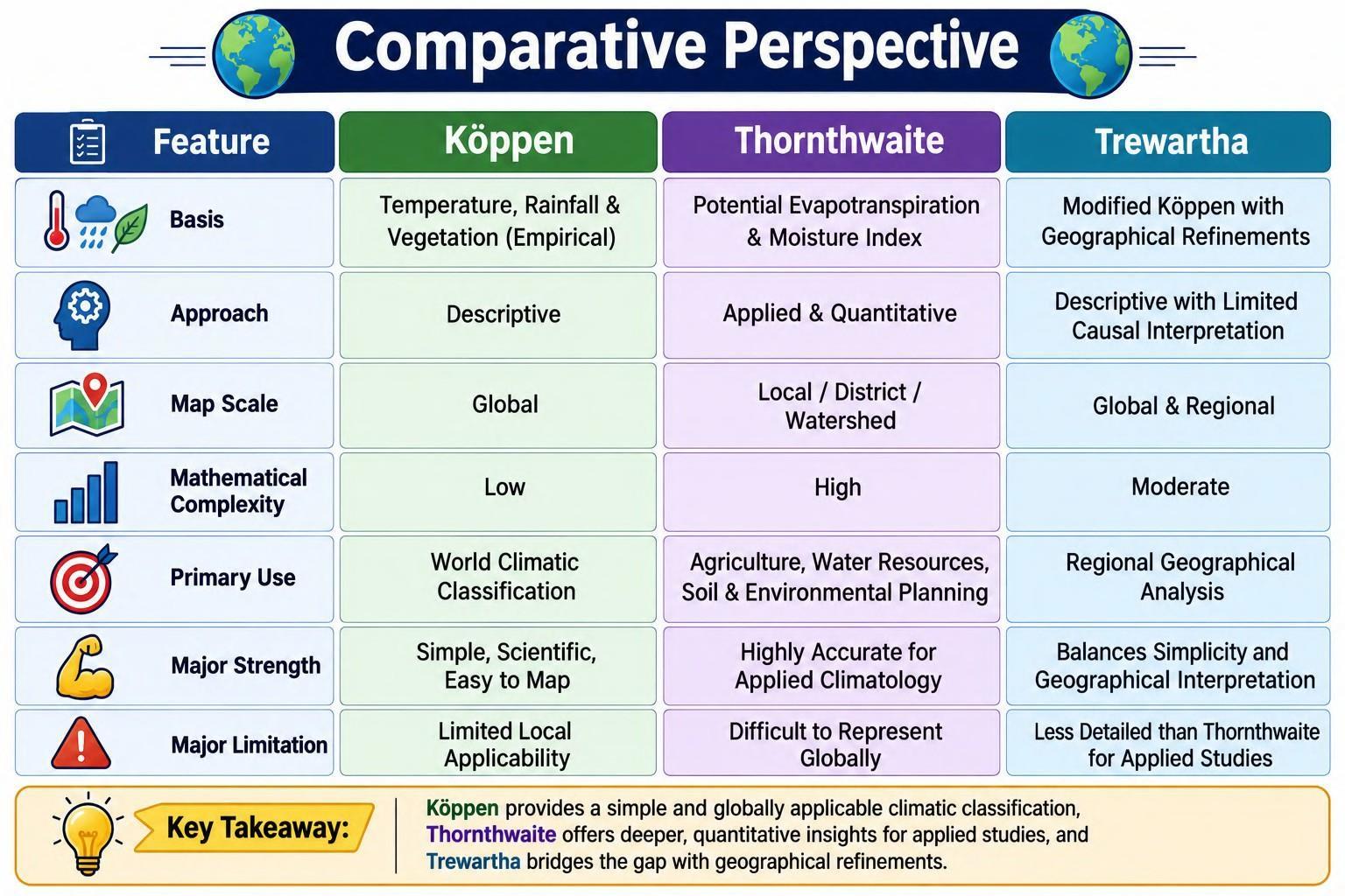 Recognising the strengths and weaknesses of both approaches, G.T. Trewartha proposed a balanced alternative. He retained Köppen’s descriptive clarity and global applicability while incorporating refinements that made climatic regions more representative of geographical reality. At the same time, he consciously avoided the excessive mathematical complexity associated with Thornthwaite’s approach, arguing that the primary objective of geography is to explain areal differentiation through clear regional patterns rather than purely statistical models. Thus, these three classification systems should be viewed not as competing theories but as complementary stages in the evolution of climatology. Together, they demonstrate how climatic classification has progressed from describing climatic regions, to quantifying climatic processes, and finally towards achieving a balance between scientific precision and geographical interpretation.
In case you still have your doubts, contact us at 9773890604
Enrol in Geography Optional by Shabbir Sir: Here
Enrol in One on One Personalized Mentorship: Here
Enrol in GS Mentorship Program: Here
Enrol In GS Mains Mentorship Program: Here
Explore One Integrated Platform for UPSC Prep: Yooki
Visit our YouTube Channel: here