Contents
- 1 1. Regional Geographical Classifications & Climatic Zones
- 2 2. South America: Landscapes and Vegetation
- 3 3. North America: Climatic Diversity
- 4 4. Australia and New Zealand
- 5 Concepts of Climatic Classification
- 6 Major Approaches to Climatic Classification
- 7 Köppen’s Climatic Classification Scheme
- 8 Conclusion
- 9 1. Major Modifications to Köppen’s Classification Scheme
- 10 2. Critical Analysis of Köppen’s Climatic Classification
- 11 PYQs
1. Regional Geographical Classifications & Climatic Zones
Understanding the world’s climatic diversity requires more than studying individual climate types in isolation. Every continent represents a unique combination of latitude, relief, atmospheric circulation, ocean currents, and historical evolution, giving rise to distinct climatic regions, ecosystems, and cultural landscapes. Among all the continents, Africa provides one of the finest examples of this relationship because almost every major tropical climatic region occurs in a systematic latitudinal sequence from north to south. As a result, the continent serves as an ideal laboratory for understanding how climate influences vegetation, natural resources, human settlement, and cultural development.
 Africa: Climatic and Cultural Patterns
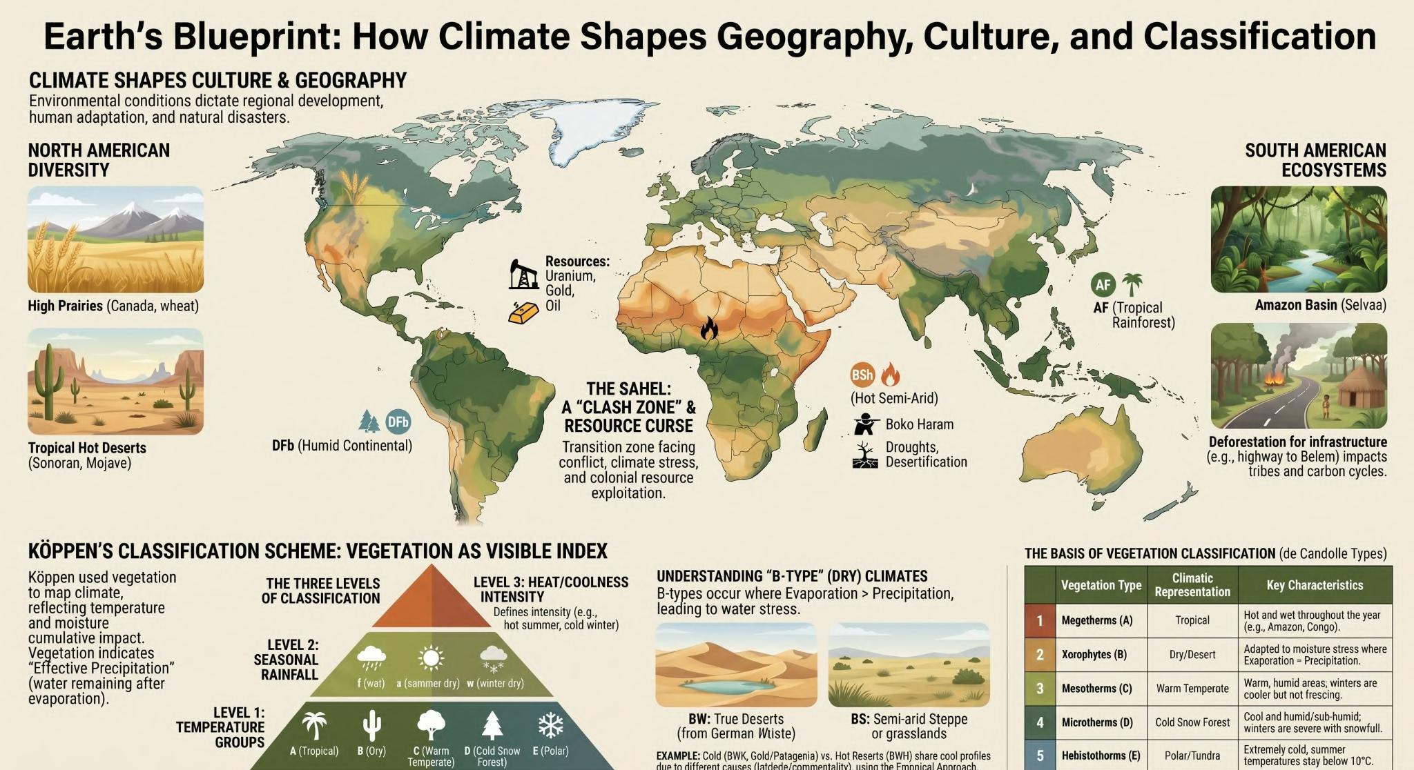
Africa extends almost symmetrically across the Equator, stretching from approximately 37° North to 35° South. This unique geographical position allows the continent to experience a remarkable range of climatic conditions arranged in broad latitudinal belts. As one moves from the Equator towards the northern or southern margins, the climate changes gradually from humid equatorial forests to tropical grasslands, deserts, and finally Mediterranean climates. This orderly climatic arrangement makes Africa one of the most geographically coherent continents in the world.
Major Climatic Zones
Equatorial Climate
The central portion of Africa, dominated by the Congo Basin, experiences a typical Equatorial Climate. This region receives abundant rainfall throughout the year due to the persistent influence of the Inter-Tropical Convergence Zone (ITCZ). High temperatures, intense convection, and continuous atmospheric instability promote luxuriant tropical rainforests, making the Congo Basin the second-largest rainfrest region in the world after the Amazon. The climate supports exceptional biodiversity and forms one of the Earth’s most important ecological regions.
The Sahara Desert
Moving northward from the Equatorial belt, rainfall decreases progressively, eventually giving way to the Sahara Desert, the world’s largest hot desert. 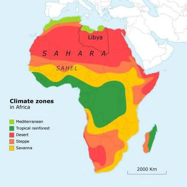
The Sahara occupies much of North Africa and owes its existence primarily to the descending air associated with the Subtropical High-Pressure Belt, combined with continentality and low atmospheric humidity. Extremely high temperatures, scarce rainfall, sparse vegetation, and frequent dust storms characterize this vast arid landscape.
The Sahel: Africa’s Transitional Belt
Immediately south of the Sahara lies the Sahel, one of the world’s most significant climatic transition zones. The Sahel forms a narrow belt separating the arid Sahara from the humid Tropical Savannah. Unlike the Sahara, the Sahel receives limited seasonal rainfall, making it highly sensitive to even small climatic fluctuations. 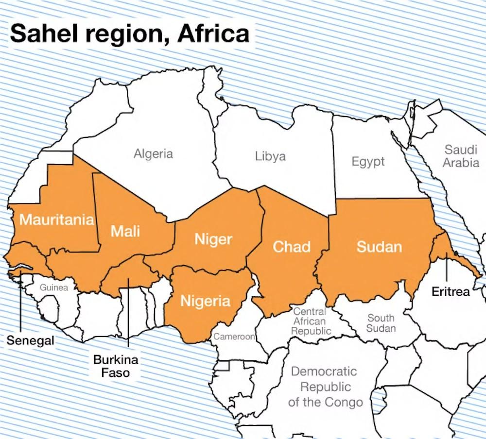 Because it represents the boundary between desert and grassland, the region frequently experiences drought, desertification, and highly variable rainfall. Its transitional nature also makes it one of the most environmentally fragile regions on Earth.
The Tropical Savannah
Further south, rainfall increases sufficiently to support the Tropical Savannah Climate. This region consists of extensive grasslands interspersed with scattered trees, forming the characteristic Parkland Landscape discussed earlier. The Savannah supports abundant wildlife and forms the ecological foundation of internationally renowned reserves such as the Masai Mara and Kruger National Park.
Mediterranean Climate
At both the northern and southern extremities of Africa, Mediterranean climatic conditions prevail. In the north, this climate extends across: ~ Morocco ~ Algeria ~ Tunisia ~ Libya while in the south it occurs around the Cape Town region. These areas experience hot, dry summers and mild, wet winters, primarily under the seasonal influence of shifting pressure belts and temperate cyclones.
Localized Monsoon Influence
Although Africa is not generally regarded as a monsoon continent, localized monsoonal conditions occur over parts of the Ethiopian Highlands (Abyssinia) and adjoining elevated regions. These areas receive seasonal rainfall influenced by regional pressure systems and relief, but monsoonal conditions remain comparatively restricted and do not dominate the continent’s overall climatic pattern.
Geopolitics and Resources of the Sahel
Beyond its climatic importance, the Sahel possesses immense geopolitical significance. The region faces numerous interconnected challenges, including:
- Recurring droughts,
- Food insecurity,
- Desertification,
- Large-scale migration,
- Political instability,
- Armed insurgencies.
Among the most prominent security threats is Boko Haram, whose activities have contributed to prolonged instability across several Sahelian countries. At the same time, the Sahel contains substantial reserves of strategically important minerals, including:
- Uranium,
- Coltan,
- Gold,
- Diamonds
- Petroleum resources.
These abundant natural resources have attracted considerable international interest while simultaneously contributing to competition over resource control and regional instability. Historically, however, the Sahel was not always associated with poverty and conflict. The region once supported flourishing civilizations such as the Ghana Empire, the Kingdom of Niger, and the historic civilization of Abyssinia (Ethiopia), demonstrating that favourable climatic phases and trans-Saharan trade once sustained prosperous societies across this transitional belt.
Cultural Geography
Climate has also played a profound role in shaping Africa’s cultural landscape. The northern part of the continent forms part of the broader Middle East and North Africa (MENA) region. This region shares strong historical, linguistic, and cultural connections with the Arabian Peninsula owing to centuries of migration, trade, and the spread of Islam. In contrast, the Sahel represents a major cultural transition zone.
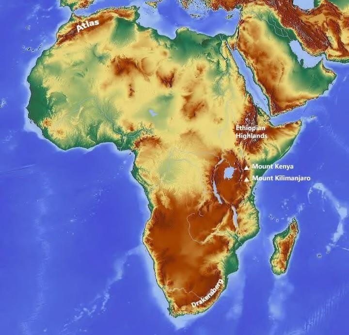 Here, the predominantly Arab and Islamic cultural sphere of North Africa gradually merges with the diverse ethnic communities, traditional African societies, and Christian populations of Sub-Saharan Africa. Consequently, the Sahel functions not only as a climatic transition zone but also as one of the world’s most important zones of cultural interaction.
Relief Features
Africa’s climatic diversity is further influenced by its distinctive relief.
Atlas Mountains
The Atlas Mountains, located in northwestern Africa, constitute an important young fold mountain system. These mountains modify regional climate by intercepting moisture-bearing winds and influencing the distribution of Mediterranean rainfall.
Drakensberg Escarpment
In contrast, the Drakensberg of southern Africa is not a fold mountain. It represents a prominent Escarpment, marking the abrupt edge of the elevated African Plateau. Its geomorphic origin and structure differ fundamentally from those of the Atlas Mountains, making this distinction particularly important from an examination perspective. Africa illustrates how climate, relief, natural resources, and culture are closely interwoven. The continent displays an almost ideal latitudinal succession of climatic zones, ranging from Equatorial Rainforests through the Savannah and Sahel to the Sahara Desert and Mediterranean regions. These climatic contrasts have profoundly influenced vegetation, patterns of settlement, resource distribution, historical civilizations, and contemporary geopolitical challenges. The Sahel, in particular, demonstrates that transitional climatic zones often become equally significant as zones of ecological vulnerability, resource competition, and cultural interaction.
2. South America: Landscapes and Vegetation
While Africa demonstrates the influence of latitudinal climatic zonation, South America illustrates how relief, atmospheric circulation, and oceanic influences interact to create an extraordinary diversity of landscapes and ecosystems. The continent extends from the Equatorial region into the temperate latitudes of the Southern Hemisphere, resulting in the coexistence of tropical rainforests, extensive grasslands, some of the world’s driest deserts, Mediterranean landscapes, and cold temperate regions. This remarkable environmental diversity makes South America one of the finest examples of the close relationship between climate, landforms, vegetation, and human activity. 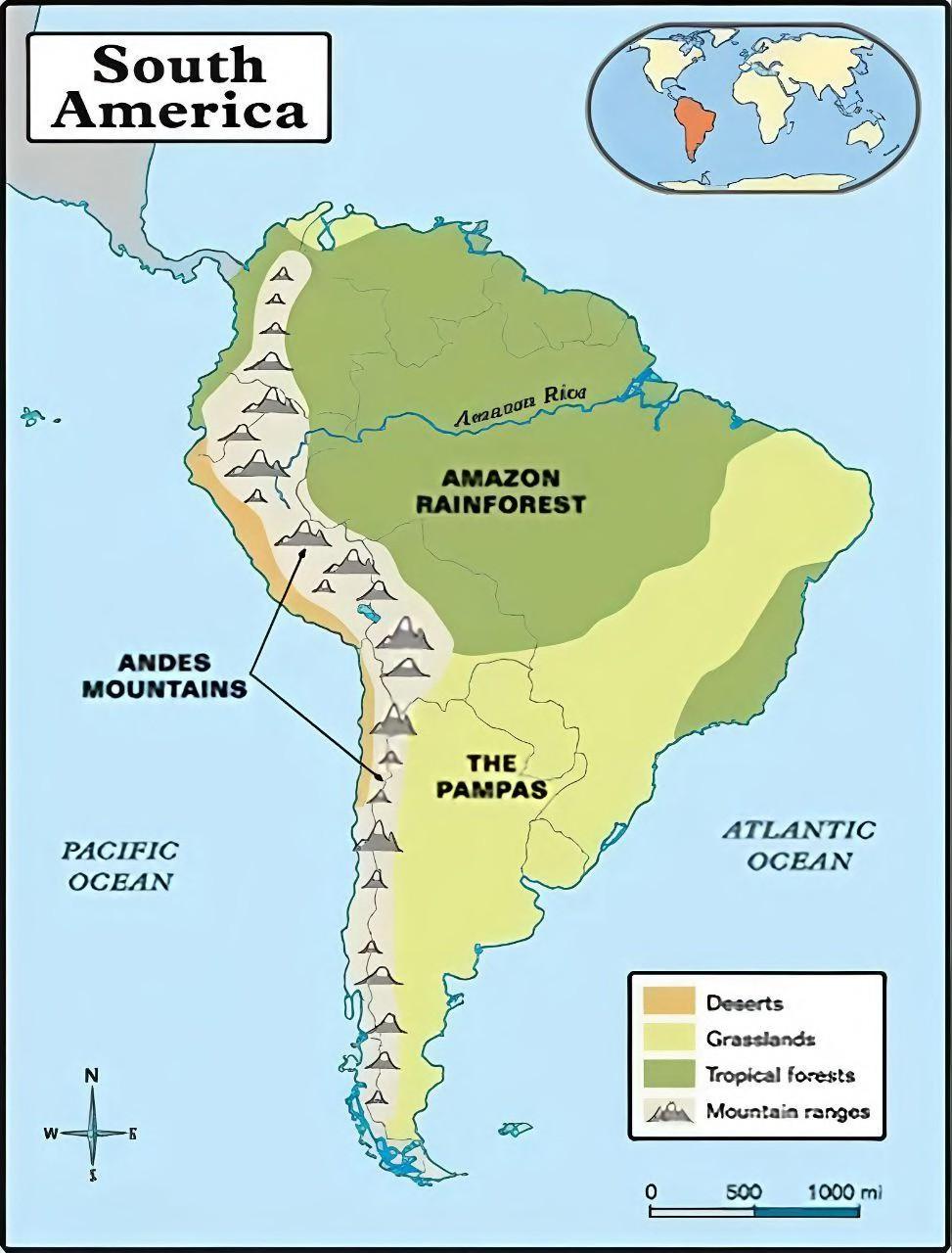
The Andes Mountains: The Great Western Cordillera
The most striking physiographic feature of South America is the Andes Mountains, a continuous mountain chain extending along the continent’s western margin. Formed through the subduction of the Nazca Plate beneath the South American Plate, the Andes constitute the longest continental mountain range in the world. The Andes act as a formidable climatic barrier, intercepting moisture-laden winds from both the Pacific and the Atlantic. Their presence creates pronounced orographic rainfall, extensive rain-shadow regions, and distinct altitudinal climatic zones, where temperature and vegetation change systematically with elevation. Consequently, the Andes exert a profound influence on regional climate, river systems, biodiversity, and patterns of human settlement throughout the continent.
The Amazon Basin: The World’s Largest Tropical Rainforest
To the east of the Andes lies the Amazon Basin, the largest drainage basin on Earth and home to the world’s most extensive tropical rainforest. These dense forests are locally known as Selvas, a term derived from the Portuguese word for forests, reflecting the historical influence of Portuguese colonization in Brazil. The Amazon owes its luxuriant vegetation to the Equatorial Climate, characterised by uniformly high temperatures, abundant humidity, and heavy convectional rainfall throughout the year. This combination supports unparalleled biodiversity and plays a critical role in regulating the global carbon cycle and hydrological system. Despite its ecological importance, the Amazon faces mounting environmental challenges. Large-scale deforestation, agricultural expansion, mining, and infrastructure development have accelerated soil degradation, habitat fragmentation, and biodiversity loss, raising concerns about the long-term stability of one of the planet’s most vital ecosystems. An important geographical landmark associated with the basin is Belém, situated near the mouth of the Amazon River. Owing to its strategic location at the gateway to the Amazon, the city has emerged as an important centre for international environmental cooperation and conservation initiatives, including global climate discussions. 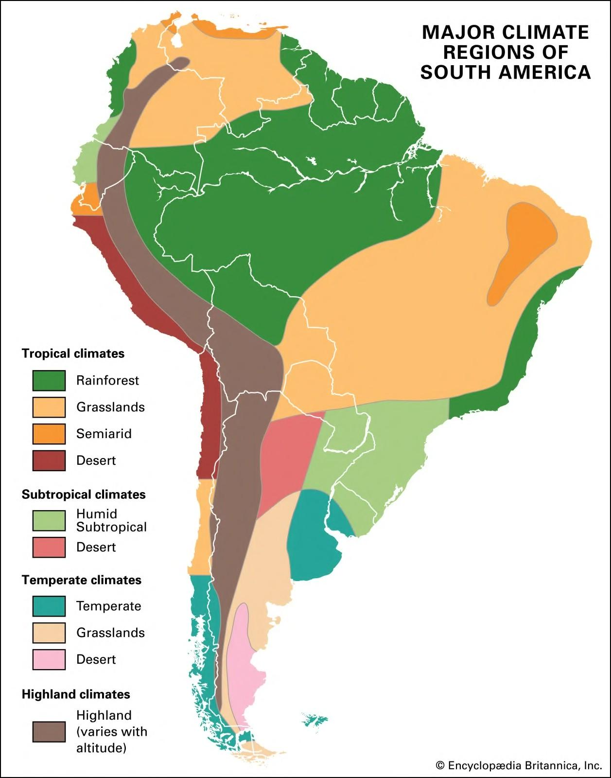
The Great Grassland Regions
Moving away from the Equatorial forests, variations in rainfall and latitude give rise to extensive grassland ecosystems, each possessing distinctive climatic characteristics. In the northern part of the continent lie the Llanos, vast tropical grasslands that develop under a pronounced wet and dry seasonal cycle. These seasonally flooded plains support extensive cattle grazing and rich wildlife habitats. Further south, the Brazilian Highlands are occupied by broad expanses of Tropical Savannah, where scattered trees intermingle with tall grasses. 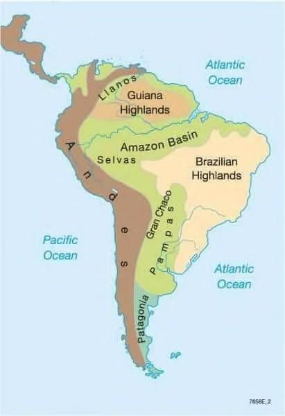 This vegetation reflects moderate seasonal rainfall and forms an important agricultural and ecological region. In the temperate latitudes of southern South America are the celebrated Pampas, among the world’s most fertile temperate grasslands. Their deep, nutrient-rich soils and favourable climate have made the Pampas one of the leading regions for commercial wheat cultivation and livestock farming, contributing significantly to the agricultural economy of countries such as Argentina and Uruguay.
The Desert Regions
South America also contains deserts formed under markedly different climatic controls. Along the western coast of Chile and Peru lies the Atacama Desert, widely recognised as the driest non-polar desert in the world. Its extreme aridity results from the combined influence of the cold Humboldt Current, the Subtropical High-Pressure Belt, and the rain-shadow effect of the Andes Mountains, all of which severely restrict precipitation. In contrast, the Patagonian Desert, situated in southern Argentina, represents a mid-latitude cold desert. Unlike the Atacama, its aridity arises primarily because the Andes block moisture-bearing westerly winds, creating an extensive rain-shadow region over Patagonia. These two deserts provide excellent examples of how similar arid landscapes may originate through entirely different atmospheric and geographical mechanisms.
Mediterranean Climate of Central Chile
Another distinctive climatic region occurs in Central Chile, particularly around Santiago. This area experiences a classic Mediterranean Climate, characterised by warm, dry summers and cool, wet winters. Seasonal shifts in pressure belts and the influence of the mid-latitude westerlies produce climatic conditions remarkably similar to those found around the Mediterranean Basin, southwestern Australia, the Cape region of South Africa, and coastal California. The favourable climate supports extensive cultivation of grapes, olives, citrus fruits, and other high-value horticultural crops, making Central Chile one of South America’s most productive agricultural regions. South America vividly demonstrates how mountain barriers, atmospheric circulation, ocean currents, and latitude interact to create exceptional geographical diversity. From the snow-covered Andes and the dense Amazon rainforest to the fertile Pampas, the hyper-arid Atacama, and the Mediterranean landscapes of Central Chile, each region reflects a distinct combination of physical processes operating across the continent. Together, these landscapes illustrate that climatic diversity is not determined by latitude alone but emerges from the continuous interaction of relief, oceans, atmospheric systems, and continental configuration.
3. North America: Climatic Diversity
While South America highlights the dominant influence of the Andes Mountains and the Equatorial rainforests on continental geography, North America presents an even greater diversity of climatic regions due to its extensive latitudinal span, varied physiography, and the combined influence of the Atlantic, Pacific, and Arctic Oceans. Stretching from the Arctic Circle to the tropical margins of Central America, the continent encompasses nearly every major climatic type, making it an excellent example of how relief, latitude, ocean currents, and atmospheric circulation interact to shape regional landscapes.
Mountain Systems
The western margin of North America is dominated by two major mountain systems—the Coast Mountains and the Rocky Mountains. 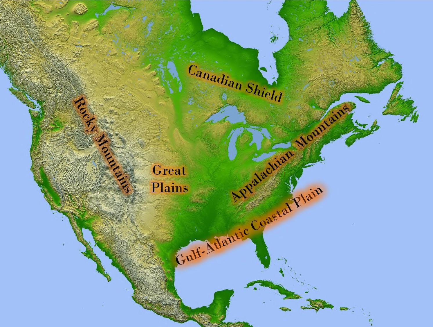 These mountain chains extend in a north-south direction and act as formidable climatic barriers. Moisture-bearing westerly winds from the Pacific Ocean are forced to ascend these mountains, producing heavy orographic rainfall along the western slopes while creating extensive rain-shadow regions towards the continental interior. Consequently, the distribution of forests, grasslands, and deserts across western North America is closely linked to the presence of these mountain systems.
The Prairie Grasslands
East of the Rockies lies the vast Prairie Grassland Region, one of the world’s most productive temperate grassland ecosystems. The Prairies may be broadly divided into two geographical units. The western portion consists of the Great Plains, an elevated piedmont region gently sloping eastward from the Rocky Mountains. The eastern portion merges into the Interior Lowlands, dominated by the extensive Mississippi River Basin, where fertile alluvial soils and favourable climatic conditions support intensive agriculture. Further north, the Prairie landscape extends into the Canadian Wheat Belt, centred around the provinces of Alberta, Saskatchewan, and Manitoba. Cities such as Regina and Winnipeg have developed as important centres of grain production and agricultural trade, making this region one of the world’s leading exporters of wheat. 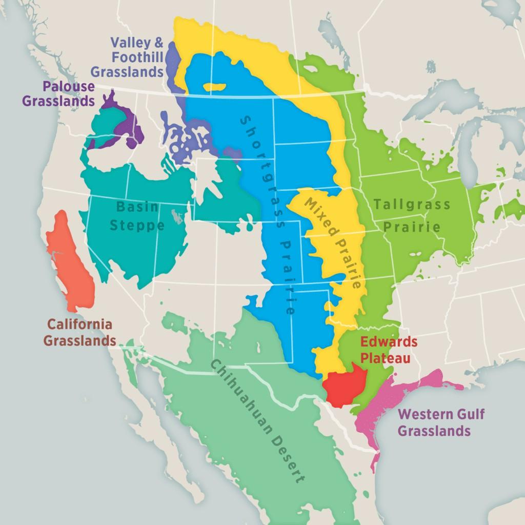
The Desert Regions
Despite its association with extensive forests and fertile plains, North America also contains significant arid landscapes. The Sonoran Desert, extending across parts of the United States-Mexico border, and the Mojave Desert of California represent classic examples of Subtropical Hot Deserts. Similar arid conditions also occur across parts of Arizona, Texas, and Utah. These deserts owe their existence to the combined influence of the Subtropical High-Pressure Belt, continentality, cold ocean currents along the Pacific coast, and the rain-shadow effect created by the western mountain ranges. Along the California Coast, particularly around San Francisco and Los Angeles, occurs a typical Mediterranean Climate. This region experiences warm, dry summers and cool, wet winters, resulting from the seasonal migration of pressure belts and the influence of the mid-latitude westerlies during winter. The favourable climatic conditions support extensive cultivation of grapes, citrus fruits, olives, and other horticultural crops, making California one of the world’s most productive agricultural regions. 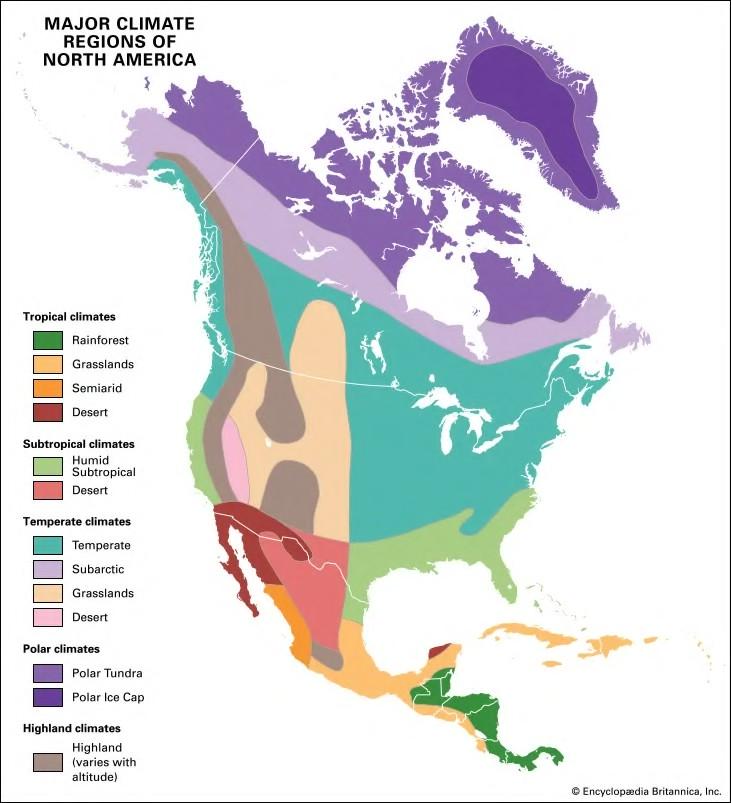
Eastern Climatic Regions
The eastern half of North America exhibits considerable climatic diversity due to the absence of major east-west mountain barriers and the influence of maritime air masses from both the Atlantic Ocean and the Gulf of Mexico. The Laurentian Climate, found in southeastern Canada and the northeastern United States, is characterised by cold winters, warm summers, and moderate precipitation throughout the year. Further south, the Gulf Type Climate develops around the Gulf of Mexico, where warm ocean waters provide abundant moisture, producing humid conditions and supporting dense vegetation and intensive agriculture. Towards the southeastern margins of the continent, climatic conditions resemble the China Type or Humid Subtropical Climate, where hot, humid summers and comparatively mild winters prevail under the influence of maritime tropical air masses. Together, these climatic regions illustrate the remarkable environmental diversity of eastern North America.
4. Australia and New Zealand
Moving from the Americas to the Southern Hemisphere, Australia and New Zealand provide another important illustration of how climatic conditions are shaped by latitude, relief, oceanic influence, and continental configuration. Although geographically close, the two countries exhibit distinctly different climatic characteristics because Australia is a vast continental landmass, whereas New Zealand consists of narrow oceanic islands strongly influenced by surrounding seas.
Grassland Regions
Australia contains extensive Temperate Grasslands, locally known as the Downs, which are among the country’s most important pastoral regions. These fertile grasslands support large-scale sheep rearing and commercial agriculture, contributing significantly to Australia’s wool and meat industries. 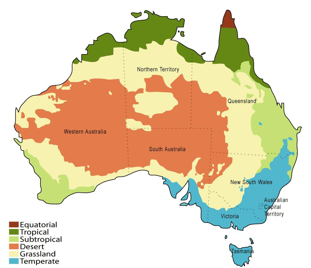 The northern parts of Australia experience Tropical Grassland (Savannah) Climate, where seasonal rainfall supports open woodland and grassland vegetation similar to that found in tropical Africa and parts of South America.
Mountain Systems
The principal mountain system of Australia is the Great Dividing Range, extending parallel to the eastern coastline. 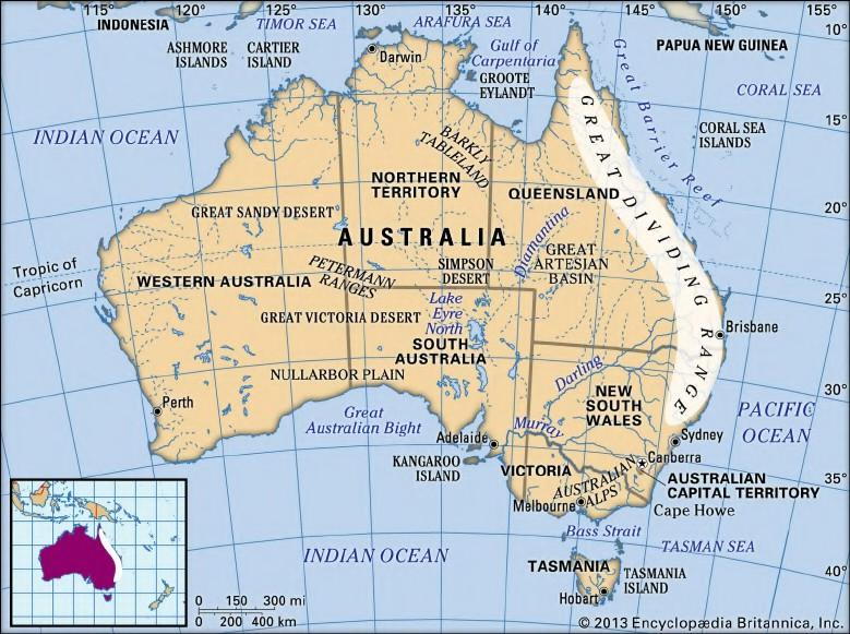 Although considerably older and lower than many of the world’s young fold mountains, this range plays a crucial role in intercepting moisture-laden winds from the Pacific Ocean, thereby influencing rainfall distribution across eastern Australia. In contrast, New Zealand is dominated by the Southern Alps, a young fold mountain system that receives heavy orographic rainfall on its western slopes while creating marked climatic contrasts across the islands.
Major Climate Types
Southern Australia, particularly around Adelaide, experiences a Mediterranean Climate, characterised by dry summers and wet winters. These climatic conditions favour viticulture, horticulture, and mixed farming. Further south, Tasmania and large parts of New Zealand experience the British Type (Cool West Margin) Climate, characterised by mild temperatures, abundant rainfall distributed throughout the year, and strong maritime influence. These conditions support lush temperate forests, extensive dairy farming, and productive pasturelands. 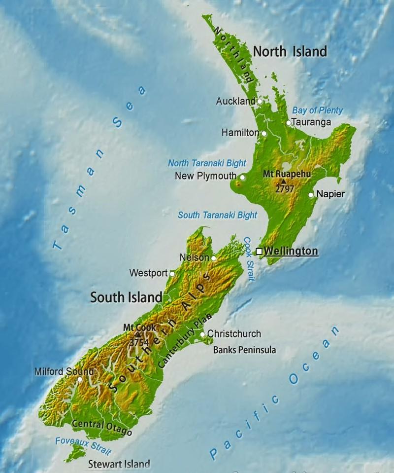 The geographical patterns observed across North America, Australia, and New Zealand reinforce the fundamental principle that climatic diversity emerges from the interaction of latitude, relief, atmospheric circulation, ocean currents, and continental configuration. Mountain systems determine rainfall patterns through orographic effects, grasslands develop under moderate seasonal precipitation, deserts occupy regions of persistent atmospheric subsidence or rain-shadow influence, while Mediterranean and maritime climates arise from the seasonal interplay of pressure belts and oceanic influences. Together, these continents demonstrate that similar climatic regions recur across the world wherever comparable physical conditions exist, forming the basis for a systematic understanding of global climatic classification.
Concepts of Climatic Classification
The geographical survey of Africa, South America, North America, Australia, and New Zealand reveals that similar climatic regions recur across different parts of the world despite vast differences in their location and physical setting. Tropical rainforests occur in both the Amazon Basin and the Congo Basin; Mediterranean climates are found not only around the Mediterranean Sea but also in California, Central Chile, Southwestern Australia, and the Cape region of South Africa. Likewise, temperate grasslands appear as the Prairies, Pampas, Steppes, and Downs, each known by a different regional name but sharing similar environmental characteristics. Such recurring geographical patterns raise an important question: Can the immense climatic diversity of the Earth be organised into a logical and systematic framework? The answer lies in the science of Climatic Classification, which seeks to identify common climatic characteristics, group similar regions together, and develop a coherent understanding of the Earth’s environmental diversity.
1. Definition and Objective
Climatic classification is the systematic process of grouping regions that exhibit similar climatic characteristics into distinct climatic types. Its primary objective is to transform the enormous complexity of the Earth’s atmosphere into an organised framework that can be analysed, compared, and interpreted scientifically. The underlying philosophy of climatic classification is that geographical phenomena are governed by identifiable patterns rather than random occurrences. Although climates vary continuously across space, these variations are not arbitrary. They emerge from the interaction of physical controls such as latitude, atmospheric circulation, ocean currents, altitude, continentality, and relief. By recognising these recurring combinations, geographers are able to classify the world’s climates into meaningful categories. The logic behind this process is comparable to biological taxonomy. Just as millions of living organisms are grouped into kingdoms, families, genera, and species based on shared characteristics, the innumerable climatic conditions found across the globe are organised into broader climatic groups. Such classification simplifies complexity without ignoring the uniqueness of individual regions, thereby providing a scientific basis for comparative geographical analysis.
2. Significance of Climate as a Deciding Factor
Climate occupies a central position in geography because it exerts a profound influence on both the physical environment and human societies. It is one of the most important determinants of natural ecosystems, economic activities, settlement patterns, and cultural evolution.
Primary Economic Activities
The distribution of rainfall and temperature largely determines the type of vegetation that develops in a region, which in turn influences agricultural practices and other primary economic activities. Regions receiving abundant and reliable rainfall support intensive cultivation and dense forests, whereas arid climates favour pastoralism or sparse agricultural activity. Thus, climatic conditions establish the ecological foundation upon which regional economies develop. 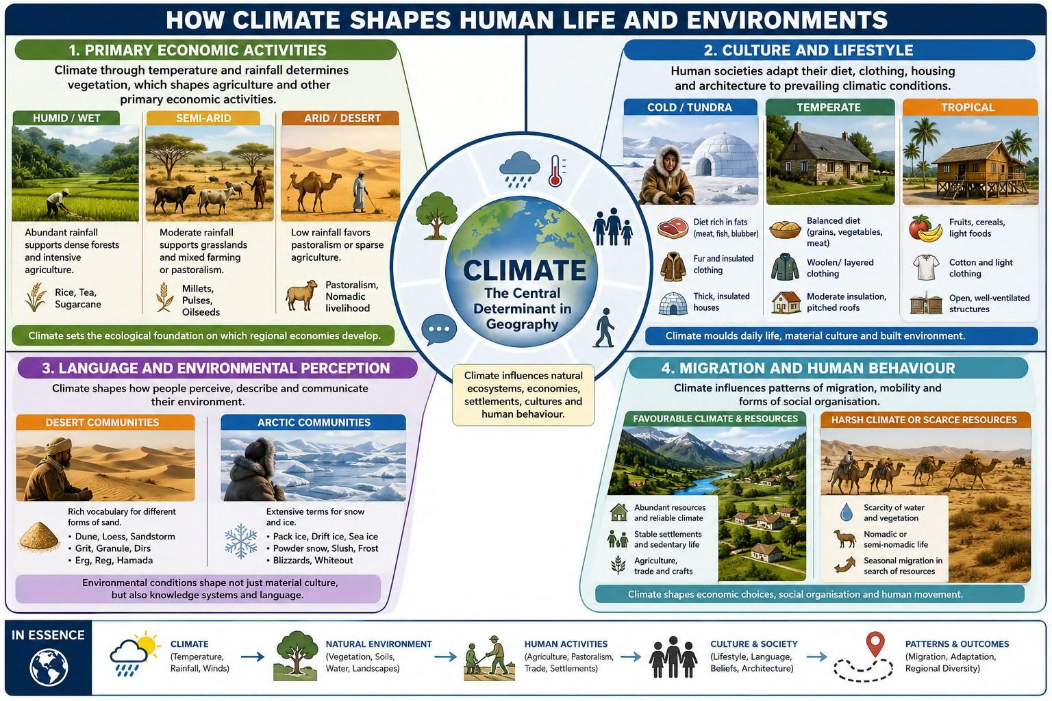
Culture and Lifestyle
Human societies have historically adapted their lifestyles to prevailing climatic conditions. Dietary habits, clothing, housing materials, and architectural styles all reflect the demands imposed by the local environment. For instance, communities living in Tundra regions traditionally consume diets rich in fats to meet high energy requirements under extremely cold conditions, whereas populations inhabiting tropical regions rely more heavily on fruits, cereals, and lighter foods. Similarly, clothing varies from cotton garments suited to hot climates to fur and insulated clothing required in polar environments. Architectural designs also differ considerably, with thick insulated walls in cold regions and open, well-ventilated structures in tropical climates.
Language and Environmental Perception
Climate also influences the evolution of language by shaping the way communities perceive and describe their surroundings. Societies develop extensive vocabularies for environmental features that are central to their daily lives. Desert communities often possess numerous expressions describing different forms of sand, while Arctic populations have developed a rich vocabulary for various types of snow and ice. These linguistic variations demonstrate how environmental conditions influence not only material culture but also systems of knowledge and communication.
Migration and Human Behaviour
Climatic conditions have historically influenced patterns of migration and mobility. Regions endowed with abundant natural resources and favourable climatic conditions often supported relatively stable, sedentary populations, whereas harsh or resource-scarce environments encouraged seasonal migration, pastoralism, or long-distance trade. For example, communities inhabiting arid regions frequently adopted nomadic or semi-nomadic lifestyles in search of water and grazing land. Such adaptations illustrate how climate shapes not only economic activities but also patterns of social organisation and human movement across landscapes.
3. Challenges in Climatic Classification
Despite its importance, constructing a universally accepted climatic classification system is far from straightforward. The atmosphere is an extremely dynamic system in which numerous elements interact simultaneously, making the task of classification both scientifically challenging and methodologically complex.
Selection of Climatic Criteria
The first challenge lies in deciding which climatic elements should serve as the basis for classification. Climate is described through several interrelated variables, including temperature, precipitation, humidity, atmospheric pressure, winds, and cloud cover. Each of these elements provides valuable information, yet no single factor is sufficient to explain the complete climatic character of a region. A classification based solely on temperature may overlook rainfall variations, while one based only on precipitation may fail to distinguish regions with contrasting thermal regimes. Consequently, selecting the most appropriate combination of climatic variables remains a fundamental challenge.
Measurement and Standardisation
Another major difficulty concerns the measurement of climatic elements. Variables such as temperature and precipitation can be measured accurately using standard instruments. However, factors such as cloudiness, solar radiation, or the persistence of atmospheric conditions are comparatively difficult to quantify in a uniform manner across different regions and time periods. The availability, quality, and duration of meteorological observations further influence the reliability of climatic classification schemes.
Complexity of Climatic Interactions
Perhaps the greatest challenge lies in integrating multiple climatic variables into a single coherent system. Climate represents the combined outcome of numerous interacting atmospheric processes rather than the influence of any single factor. Temperature, rainfall, humidity, winds, pressure systems, ocean currents, and relief continuously interact to produce distinctive regional climates. Capturing this complexity within a classification framework requires careful balancing between scientific accuracy and practical simplicity. For this reason, different geographers have developed different systems of climatic classification, each emphasising particular climatic characteristics while addressing specific geographical objectives. The transition from studying individual climatic regions to developing systematic classification schemes represents a significant step in geographical analysis. While regional geography highlights the uniqueness of individual landscapes, climatic classification seeks to identify the common principles that unite them. By organising the Earth’s immense climatic diversity into logical categories, geographers are able to compare regions, explain environmental patterns, and establish a scientific foundation for understanding the relationship between climate, vegetation, ecosystems, and human life. This intellectual framework ultimately paved the way for the development of major climatic classification
Major Approaches to Climatic Classification
The challenges associated with climatic classification naturally gave rise to an important question: What should be the basis for classifying climate? Should geographers classify climates according to what is observed, such as temperature and rainfall, or according to the physical processes that produce those climatic conditions? This debate led to the development of two broad approaches to climatic classification—Empirical and Genetic. Although both seek to organise the Earth’s climatic diversity, they differ fundamentally in their methodology and objective.
Empirical Approach
The Empirical Approach classifies climates on the basis of directly observable and measurable climatic elements. Instead of investigating the causes of climate, it focuses on the climatic conditions actually experienced at a particular location. Parameters such as temperature, precipitation, humidity, wind characteristics, and their seasonal variations are analysed to identify regions exhibiting similar climatic behaviour.

Since these variables can be measured objectively through meteorological observations, empirical classifications are relatively simple to construct and are widely used for climatic mapping and regional comparison. The principal advantage of this approach lies in its practical applicability. Regions with comparable climatic statistics are grouped together regardless of the physical mechanisms responsible for producing those conditions. Prominent scholars associated with the empirical tradition include Wladimir Köppen, C. W. Thornthwaite, and Miller, whose classification systems continue to influence modern climatology.
Genetic Approach
In contrast, the Genetic Approach attempts to explain why particular climatic conditions exist. Rather than beginning with observed temperature or rainfall data, this approach investigates the physical processes responsible for generating climate. It considers the influence of factors such as solar insolation, albedo, air masses, planetary circulation, latitude, altitude, ocean currents, and other components of the Earth’s energy balance. Thus, climates are classified according to their origin and controlling mechanisms rather than merely their observable characteristics. The genetic approach provides a deeper scientific understanding of atmospheric processes and is particularly valuable in theoretical climatology, where explaining climatic causation is as important as describing climatic patterns. Among the leading contributors to this approach are Terjung, Budyko, and Hidore, whose work emphasised the physical controls governing the Earth’s climatic systems. Although the empirical and genetic approaches differ in methodology, they are not mutually exclusive. The empirical approach answers the question “What type of climate exists?”, whereas the genetic approach explains “Why does that climate exist?” Together, these two approaches provide complementary perspectives, combining descriptive accuracy with physical explanation. Most modern climatological studies draw upon both traditions to develop a comprehensive understanding of the Earth’s climatic diversity.
Köppen’s Climatic Classification Scheme
Among the various empirical classification systems developed over the past century, the Köppen Climatic Classification remains the most influential and widely accepted. Its enduring popularity arises from its simplicity, scientific consistency, and close relationship with the natural distribution of vegetation. By establishing a direct connection between climate and plant communities, Köppen transformed complex meteorological observations into a practical and globally applicable system of climatic classification.
1. The Methodology: A Reverse Engineering Approach
One of the greatest challenges in climatic classification is the enormous complexity of atmospheric data. Temperature, rainfall, humidity, pressure, and winds vary continuously across both space and time, making it difficult to identify clear climatic boundaries directly from meteorological observations. To overcome this problem, Wladimir Köppen adopted an innovative approach that may be described as “reverse engineering.” Instead of beginning with climatic measurements, Köppen started with the natural vegetation found across different parts of the world. The reasoning behind this approach was both simple and scientifically sound. Plants are sedentary organisms. Unlike animals, they cannot migrate in response to unfavourable environmental conditions. Their survival depends entirely upon adapting to the prevailing combination of temperature, moisture availability, and seasonality at a particular location. Consequently, vegetation serves as a reliable long-term indicator of climatic conditions. If two distant regions support similar natural vegetation, it is reasonable to infer that they experience broadly similar climatic environments. 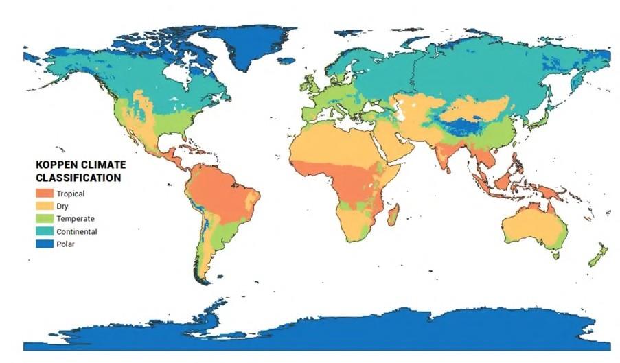 To develop his classification, Köppen relied extensively on the global vegetation map prepared by the Swiss botanist Alphonse de Candolle in 1874, which provided one of the earliest systematic representations of the world’s major vegetation regions. By correlating these vegetation patterns with observed climatic data, Köppen constructed a climatic classification that reflected both meteorological reality and ecological response.
2. Vegetation Types: The Basis of Classification
Using natural vegetation as the starting point, Köppen recognised five broad vegetation groups, each corresponding to a distinct climatic regime.
Megatherms (A)
The Megathermal group represents regions characterised by consistently high temperatures and abundant moisture throughout the year. These conditions favour luxuriant tropical rainforests and correspond to the Equatorial Climatic Region, where dense evergreen forests dominate the landscape. 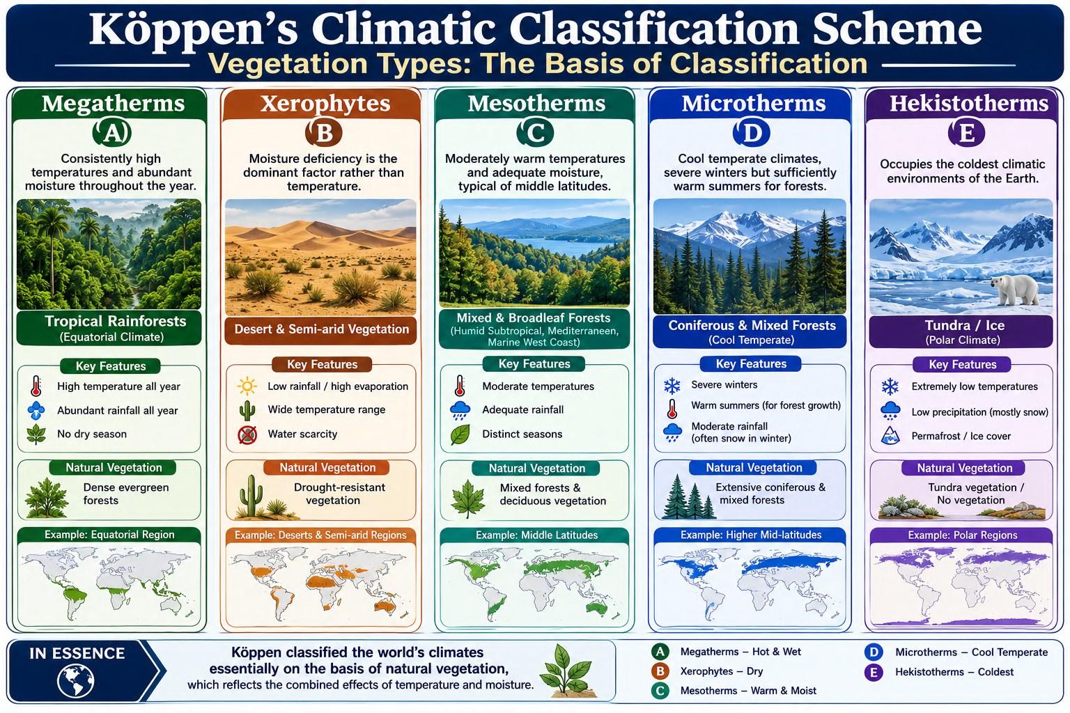
Mesotherms (C)
The Mesothermal group includes regions with moderately warm temperatures and adequate moisture, typically found in the middle latitudes. These climates support mixed forests and broadleaf deciduous vegetation and include climatic regions such as the Humid Subtropical, Mediterranean, and Marine West Coast climates.
Microtherms (D)
The Microthermal group represents cool temperate climates, where winters are severe but summers remain sufficiently warm to sustain forest vegetation. These regions are generally associated with extensive coniferous and mixed forests occurring across higher mid-latitudes.
Hekistotherms (E)
The Hekistothermal group occupies the coldest climatic environments of the Earth. Extremely low temperatures restrict plant growth, resulting in Tundra vegetation or complete absence of vegetation where permanent ice dominates the landscape.
Xerophytes (B)
Unlike the other groups, the Xerophytic category is controlled primarily by moisture deficiency rather than temperature. These regions support drought-resistant vegetation specifically adapted to arid conditions and include the world’s deserts and semi-arid landscapes.
3. The Three Levels of Classification
Köppen developed a hierarchical system in which climates are classified progressively using three successive criteria.
First Level: Temperature Regime
The first stage divides the Earth’s climates according to monthly mean temperature, producing the major climatic groups.
- A Type (Tropical Climate): The mean temperature of the coldest month remains above 18°C, indicating the absence of a true winter.
- C Type (Warm Temperate Climate): The coldest month’s temperature lies between 18°C and –3°C, representing regions with mild winters.
- D Type (Cold Temperate Climate): Winters are colder than –3°C, while at least one summer month records temperatures above 10°C, permitting forest growth.
- E Type (Polar Climate): Even the warmest month remains below 10°C, preventing the development of forests.
Within the E Group, Köppen further distinguished two important subtypes:
- ET (Tundra Climate): Summer temperatures range between 0°C and 10°C, allowing limited tundra vegetation.
- EF (Ice Cap Climate): Temperatures remain below 0°C throughout the year, producing permanent snow and ice.
Second Level: Seasonal Distribution of Rainfall
Once the major temperature groups are identified, Köppen distinguishes climates according to the seasonal distribution of precipitation. He introduced a series of lowercase symbols derived largely from German terminology:
- f (feucht): Rainfall occurs throughout the year without a pronounced dry season.
- s: Summers are comparatively dry.
- w: Winters constitute the dry season.
- m: Monsoonal climates characterised by strong seasonal concentration of rainfall.
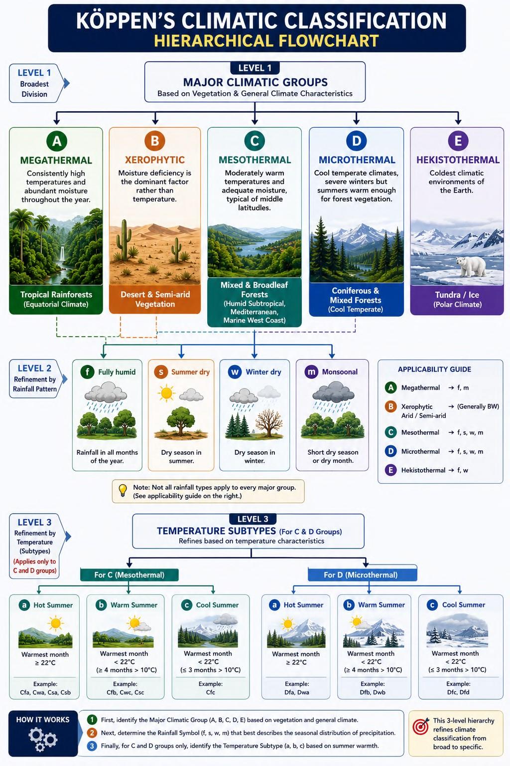
These symbols enable climates possessing similar temperatures but contrasting rainfall regimes to be distinguished accurately.
Third Level: Summer Temperature Characteristics
The final level applies primarily to the C and D climatic groups and differentiates climates according to summer temperature intensity.
- a: Hot summers with the highest seasonal temperatures.
- b: Moderately warm summers.
- c: Cool and comparatively short summers.
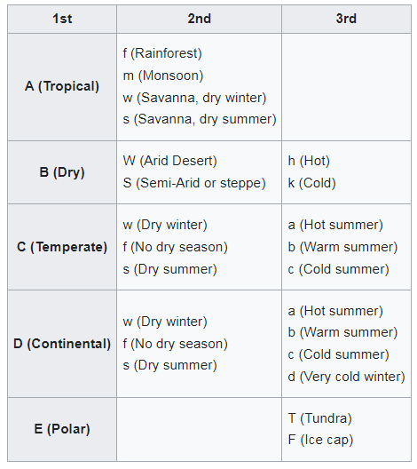
This final refinement allows Köppen’s classification to represent subtle climatic differences within broadly similar climatic regions. Köppen’s classification demonstrates how a complex global climatic system can be organised through a logical hierarchy. Beginning with temperature, refining the classification through seasonal rainfall, and finally incorporating summer thermal characteristics, the system progressively narrows broad climatic groups into highly specific climatic types. By using natural vegetation as the ecological expression of climate, Köppen successfully established one of the most practical and enduring climatic classification systems in geography, providing a common framework for comparing climatic regions across the world.
Conclusion
The immense climatic diversity of the Earth is governed by underlying physical principles that produce recurring environmental patterns across continents. Similar combinations of temperature, precipitation, atmospheric circulation, and seasonal rhythms give rise to comparable climatic regions, vegetation communities, and human adaptations, irrespective of their geographical location. Climatic classification provides the scientific framework for recognising these patterns, transforming the apparent complexity of the Earth’s atmosphere into an organised and comparable system. Among the various classification schemes, Köppen’s Climatic Classification occupies a unique position because it successfully integrates climate and natural vegetation, using ecological response as a reliable indicator of long-term atmospheric conditions. Its hierarchical structure not only simplifies the study of global climates but also establishes a common language for analysing regional environments. Consequently, climatic classification serves as the conceptual bridge between atmospheric processes, ecosystems, and human geography, enabling a systematic understanding of the spatial organisation of the Earth’s climatic landscapes.
1. Major Modifications to Köppen’s Classification Scheme
Although Köppen’s Climatic Classification gained worldwide acceptance because of its simplicity and close association with natural egetation, continued advances in climatology revealed several limitations in the original framework. As meteorological observations became more extensive and the understanding of atmospheric processes improved, geographers recognised that certain climatic regions could not be adequately represented within Köppen’s original categories. Consequently, the classification underwent a series of modifications aimed at improving its global applicability while preserving its fundamental structure. Two of the most significant refinements were the introduction of the Monsoon (M-type) and the Highland (H-type) categories, both of which addressed important climatic situations that the original scheme could not explain satisfactorily.
Introduction of the Monsoon (M-Type)
One of the earliest and most influential modifications was incorporated through the Köppen–Geiger–Pohl revision, which introduced a separate Monsoon (M-type) category. The need for this modification arose because Köppen’s original classification did not adequately distinguish regions experiencing a monsoonal rainfall regime from other tropical climates. Many tropical regions receive abundant rainfall, yet their seasonal distribution and atmospheric mechanisms differ considerably. The original system was therefore unable to capture the distinctive climatic character of monsoon regions. To overcome this limitation, the revised classification recognised Monsoon Climate (Am) as a separate climatic subtype. However, it is important to note that the classification does not define monsoon on the basis of seasonal wind reversal, which is the traditional geographical definition of a monsoon. Instead, it identifies monsoonal climates purely through their rainfall characteristics, consistent with the empirical nature of Köppen’s methodology. This approach ensured that monsoonal climates could be identified objectively using measurable rainfall data, even though it did not explicitly incorporate the atmospheric circulation responsible for monsoon formation.
Introduction of the Highland (H-Type)
Another important limitation of the original Köppen system concerned mountainous regions. Köppen’s classification primarily considered latitude as the principal control of temperature. However, in high mountain environments, altitude exerts an equally significant influence on climatic conditions. Temperature decreases with increasing elevation, producing climatic characteristics that differ markedly from those expected solely on the basis of latitude. As a result, mountainous areas often contain multiple climatic zones within relatively short horizontal distances due to vertical climatic zonation. A single mountain may support tropical vegetation at its base, temperate forests at intermediate elevations, alpine meadows higher up, and permanent snow near its summit. The original Köppen framework could not adequately represent these highly complex climatic transitions. To address this deficiency, later modifications introduced the Highland (H-type) category, specifically recognising climates where altitude becomes the dominant climatic control. The inclusion of the Highland category greatly improved the applicability of Köppen’s classification to major mountain systems such as the Himalayas, Andes, Rockies, and East African Highlands, where climatic conditions are determined as much by elevation as by latitude. 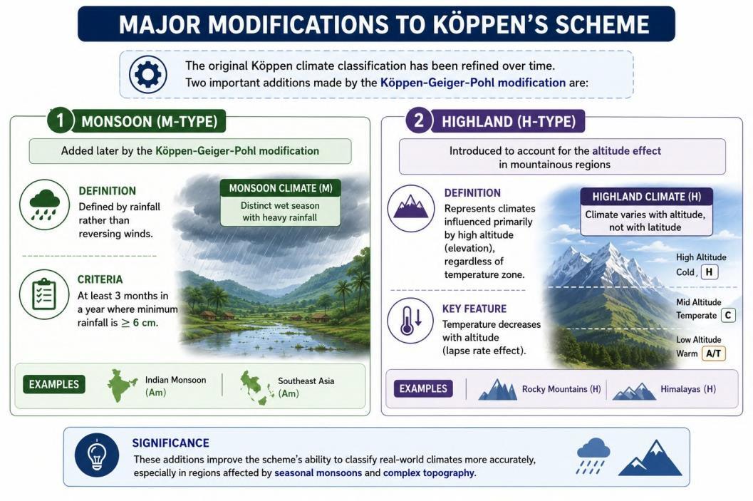 The modifications introduced into Köppen’s classification illustrate an important principle in the evolution of scientific knowledge: classification systems are continually refined as new observations and better understanding become available. While Köppen successfully established a practical framework based on temperature, rainfall, and vegetation, later climatologists recognised that distinctive climatic environments such as monsoon regions and high mountain areas required separate consideration. These refinements preserved the strengths of Köppen’s empirical approach while making the system more representative of the Earth’s climatic diversity.
2. Critical Analysis of Köppen’s Climatic Classification
The modifications introduced through the Köppen–Geiger–Pohl revision significantly improved the original classification by incorporating Monsoon and Highland climates. However, these refinements did not eliminate all of the conceptual limitations inherent in Köppen’s empirical approach. As climatology evolved from a largely descriptive discipline towards a more analytical science, geographers increasingly questioned whether a classification system based primarily on observable climatic patterns could adequately explain the complexity of the Earth’s atmospheric processes. Consequently, Köppen’s classification must be evaluated not only for its remarkable strengths but also for the limitations that eventually encouraged the development of more refined climatic classification systems.
Merits of Köppen’s Classification
One of the greatest strengths of Köppen’s classification is its scientific simplicity. By establishing objective climatic boundaries based on measurable variables such as temperature and precipitation, the system replaced subjective descriptions with clearly defined climatic criteria. This made climatic classification more consistent, reproducible, and universally applicable. Another remarkable contribution was Köppen’s innovative use of natural vegetation as the visible expression of climate. Instead of treating climate and vegetation as separate geographical phenomena, he demonstrated that vegetation reflects the long-term interaction of temperature and moisture conditions. This ecological perspective made the classification both scientifically meaningful and easy to interpret. The system also possesses impressive global coverage. It successfully accommodates virtually all the major climatic regions of the world, including Equatorial Rainforests, Tropical Savannas, Hot and Cold Deserts, Mediterranean Climates, Temperate Forests, Taiga, Tundra, and Polar Ice Caps. This comprehensive nature has enabled it to become one of the most widely accepted climatic classification systems across the world. Another important advantage lies in its cartographic convenience. The use of concise alphabetical symbols allows climatic regions to be represented clearly on world maps, making global climatic comparisons both simple and visually effective. For this reason, Köppen’s climatic maps continue to be extensively used in geographical education, research, and atlases.
Limitations of Köppen’s Classification
Despite its strengths, Köppen’s classification possesses several important limitations. The first criticism is that the system is too generalised. It was designed primarily to classify climates at the global scale, making it highly effective for understanding broad climatic patterns across continents. However, this generalisation often overlooks the considerable climatic variations that exist within individual regions. Consequently, it is less suitable for analysing local climatic diversity or regional environmental conditions. A related limitation is its limited applied significance. Since Köppen’s climatic regions are relatively broad, the system provides only a general climatic framework. It cannot adequately support crop-specific agricultural planning, micro-level urban planning, watershed management, or local disaster risk assessment, all of which require far more detailed climatic information than broad climatic categories can provide. A more fundamental criticism concerns the empirical nature of the classification. Köppen classified climates according to observable climatic conditions, but he did not explain the physical processes responsible for producing those climates. In other words, the system describes what climate exists but does not adequately explain why it exists. This limitation becomes evident when comparing regions such as the Patagonian Desert of South America and the Gobi Desert of Central Asia. Although Köppen classifies both as cold deserts (BWk) because they exhibit similar temperature and rainfall characteristics, the causal mechanisms responsible for their aridity are fundamentally different. The Patagonian Desert owes its dry conditions primarily to the rain-shadow effect created by the Andes Mountains, whereas the Gobi Desert is largely a product of extreme continentality, being situated far from major moisture sources. By assigning both regions to the same climatic category without distinguishing their underlying causes, Köppen’s classification overlooks important geographical differences that are essential for understanding climatic processes. This illustrates the broader limitation of all empirical classification systems: they describe climatic outcomes but not the atmospheric mechanisms responsible for producing them.
Limitations in the Indian Context
The shortcomings of Köppen’s classification become particularly evident when applied to India. The Indian climate is overwhelmingly governed by the seasonal distribution of monsoon rainfall, which directly influences agriculture, water resources, settlement patterns, and economic activity. In India, rainfall is the most significant climatic variable, often exerting a greater influence on human life than temperature alone. However, Köppen’s classification assigns primary importance to temperature for most climatic groups and considers rainfall largely as a secondary criterion, except in B-type (Dry) climates. As a result, regions experiencing similar thermal conditions but markedly different monsoon characteristics may be grouped together despite substantial differences in agricultural potential and environmental conditions. Consequently, Köppen’s classification is often considered less suitable for representing the climatic realities of the Indian subcontinent, where rainfall seasonality constitutes the defining characteristic of regional climate.
PYQs
1. Describe latitudinal distribution of Köppen’s classification of world climate. (15 Marks/2024)
2. Explain the techniques to calculate potential evapotranspiration suggested by Thornthwaite. (10 Marks/2019)
3. Critically examine the basis and scheme of climatic classification proposed by G.T.Trewartha. (15 Marks/2018)
4. Discuss the basis of Koppen’s climatic classification of ‘Cs’ type of climate. (20 Marks/2015)
5. Discuss the main features of the climatic classification system evolved by Koppen. Also point out its Anomalies. (2005)
6. Discuss the criteria which Thornthwaite adopted for his 1948 classification of the World climate. (2002)
7. Write short note: Cs type of climate, as per Koppen’s classification. (1999)
8. Examine critically the drawbacks of Koppen’s Classification of climates. Explain how Thornthwaite attempted to overcome Koppen’s limitations. (1996)
9. Explain the basis of Koppen’s classification of climates. Also mention its merits and limitations. (1994)
10. Explain the basic criteria used in Thornthwaite’s 1948 classification of climates. (1990)
11. Compare the basis of the climatic classification of Koppen with that of Thornthwaite’s classification. (1986)
In case you still have your doubts, contact us on 9773890604
Enrol in Geography Optional by Shabbir Sir: Here
Enrol in One on One Personalized Mentorship: Here
Enrol in GS Mentorship Program: Here
Enrol In GS Mains Mentorship Program: Here
Explore One Integrated Platform for UPSC Prep: Yooki
Visit our YouTube Channel: here