Contents
- 1 Rimland Theory of Nicholas Spykman
- 1.0.1 Introduction: From Heartland to Rimland
- 1.0.2 Nicholas Spykman: Thinker Profile
- 1.0.3 1. From Heartland to Rimland
- 1.0.4 2. Mackinder’s Dictum versus Spykman’s Dictum
- 1.0.5 3. Why is the Rimland Strategically Powerful?
- 1.0.6 4. Spykman’s Critique of the Heartland
- 1.0.7 5. Political Fragmentation of the Rimland
- 1.0.8 6. Analytical Framework: Why Rimland Matters
- 1.1 Regional Case Studies & US Containment Policy
- 1.1.1 1. Western Europe: Post-WWII Reconstruction & Containment
- 1.1.2 Marshall Plan: Economic Containment
- 1.1.3 NATO: Military Containment
- 1.1.4 Franco-German Reconciliation: Political Stabilisation
- 1.1.5 Germany: The Rimland Divided
- 1.1.6 2. Middle East/West Asia: Chokepoints, Energy & Strategic Leverage
- 1.2 India & the Indian Ocean Region, India as a Rimland Power
- 1.3 1. Island Territories as Strategic Assets
- 1.4 2. India–US Strategic Convergence
- 1.5 LEMOA, 2016
- 1.6 India’s Maritime Initiatives
- 1.7 China, South China Sea & the Indo-Pacific
- 1.7.0.1 China as an Emerging Rimland Power
- 1.7.0.2 1. The Malacca Dilemma
- 1.7.0.3 China’s Malacca Bypass Strategy
- 1.7.0.4 Myanmar Pipeline
- 1.7.0.5 2. CPEC
- 1.7.0.6 Malaysia ECRL
- 1.7.0.7 Eurasian Overland Routes
- 1.7.0.8 3. South China Sea: Maritime Territorial Assertion
- 1.7.0.9 Major Disputed Features
- 1.7.0.10 4. US Counter-Containment / Balancing Network
- 1.7.0.11 QUAD
- 1.7.0.12 AUKUS
- 1.7.0.13 EDCA: Philippines
- 1.7.0.14 The Contemporary Rimland Security Competition
- 1.7.1 In case you still have your doubts, contact us on 9773890604
Rimland Theory of Nicholas Spykman
Introduction: From Heartland to Rimland
Geopolitical theories attempt to explain how geographical location, spatial control and physical connectivity influence the behaviour of states and the distribution of global power. In classical geopolitics, geography was treated not merely as the physical setting of international politics, but as a major determinant of strategic possibilities, territorial competition and power projection. 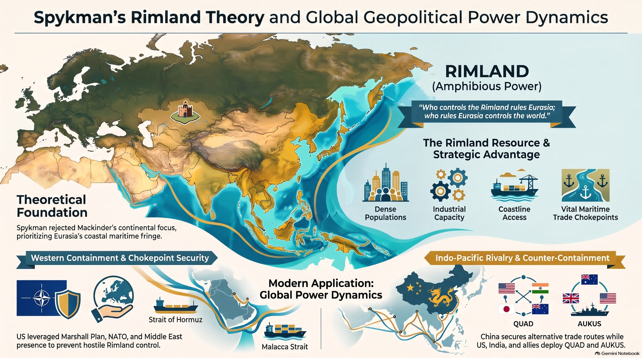 Halford Mackinder’s Heartland Theory placed the continental interior of Eurasia at the centre of global power. Mackinder argued that control over the Eurasian Heartland could provide the geographical foundation for wider domination of the World-Island, comprising Europe, Asia and Africa. Nicholas Spykman, however, challenged this continental-centric interpretation. He shifted attention from the inaccessible Eurasian interior to the maritime peripheral zones surrounding it, developing what came to be known as the Rimland Theory.
Nicholas Spykman: Thinker Profile
 Nicholas John Spykman was a Dutch-born American political scientist and strategist whose work was closely connected with the strategic concerns of the United States. His major work, The Geography of the Peace, was published posthumously in 1944, following his death in 1943. The difference in strategic orientation between Mackinder and Spykman is important. Mackinder’s thinking emerged from a British imperial perspective, where control over Eurasian land power was a central concern. Spykman, in contrast, formulated his geopolitical framework primarily for the American strategic establishment, with particular attention to the security of the United States in relation to Eurasian power. Thus, Spykman’s central concern was not simply who controls the Eurasian interior, but who controls the peripheral regions through which Eurasia connects with the maritime world. Mackinder emphasised the Eurasian interior as the geographical core of world power, whereas Spykman shifted the strategic focus towards the Eurasian periphery. This represented a movement from a predominantly continental conception of power towards a more amphibious and maritime-oriented conception of geopolitics.
1. From Heartland to Rimland
Spykman’s central argument was that the coastal margins of Eurasia possessed greater strategic significance than the landlocked Heartland itself. These peripheral regions combined access to the resources and populations of the Eurasian landmass with access to the world’s oceans.
Spykman therefore conceptualised the Rimland as the broad maritime fringe surrounding the Eurasian landmass. It was neither purely continental nor purely maritime. Its strategic significance arose precisely from this intermediate character. Rimland states possessed the possibility of combining land power with sea power, giving them what may be described as amphibious strategic capabilities.
Rimland as the “Inner Crescent”
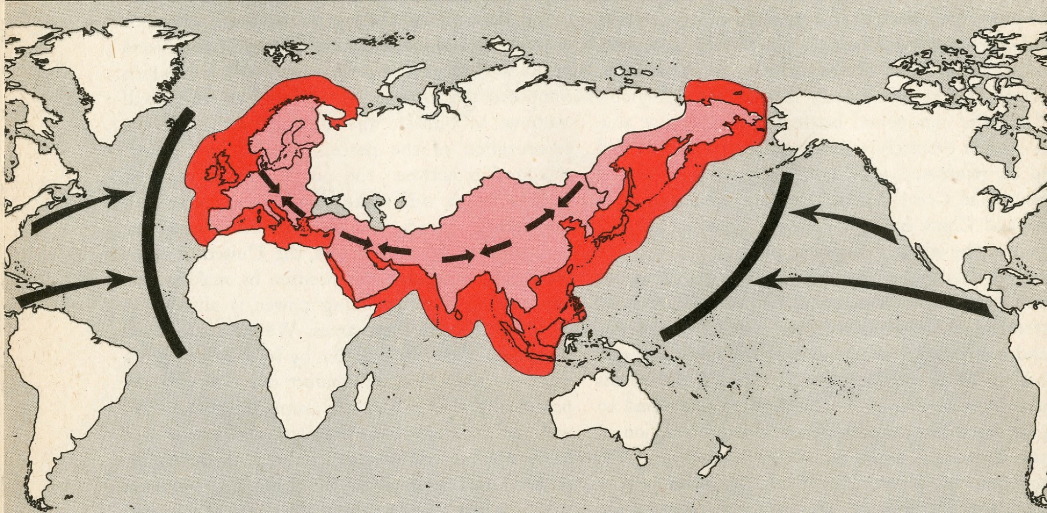 The Rimland broadly corresponds to the coastal and near-coastal regions surrounding Eurasia. It forms a strategic belt between the Eurasian Heartland and the surrounding maritime spaces.
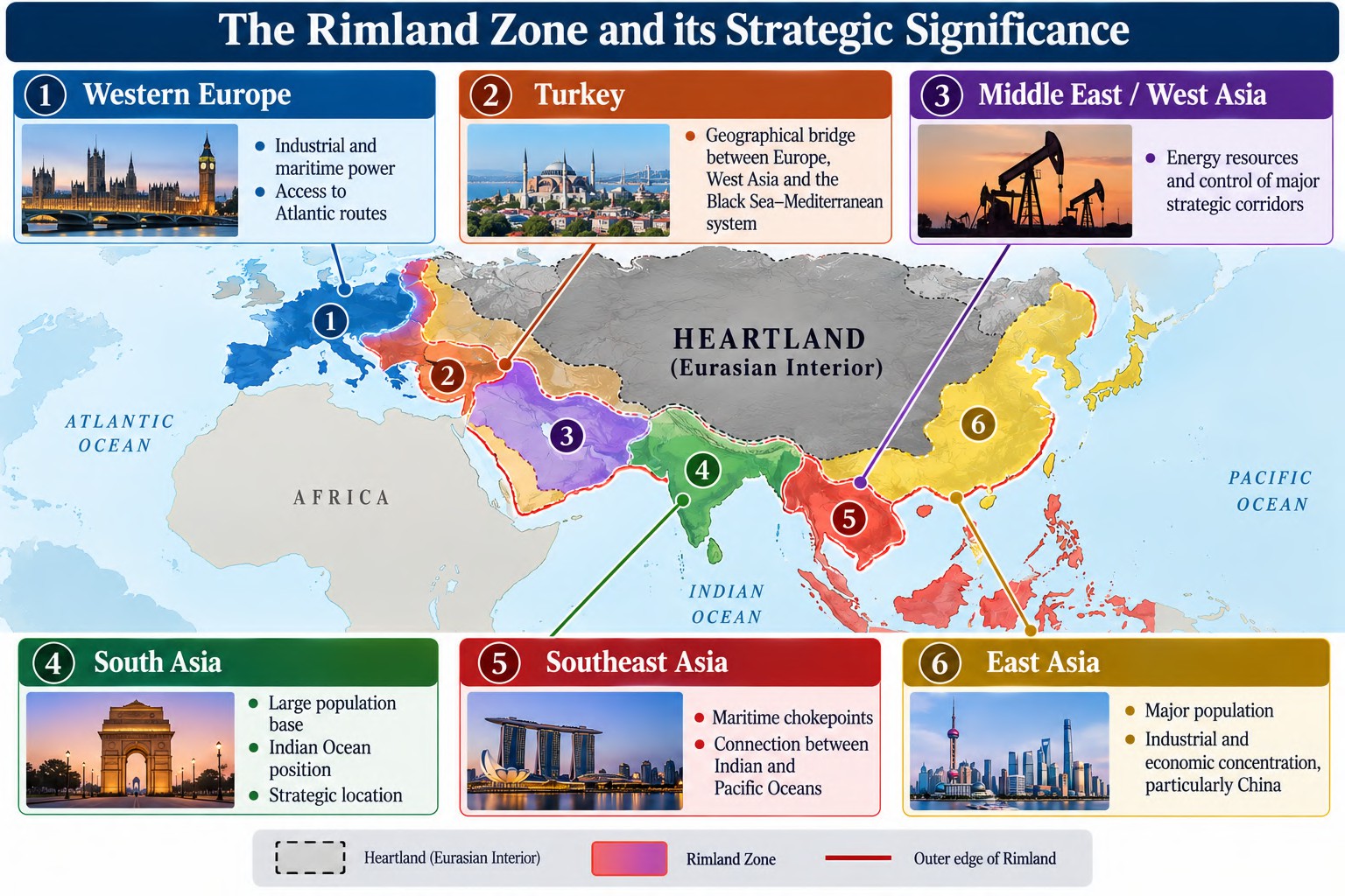 For analytical purposes, the Rimland can be understood through six major geographical zones:The importance of these regions derives from their combination of population, resources, industrial capacity and maritime access. Unlike the relatively isolated Heartland, the Rimland is deeply connected to both the continental interior and the global maritime system.
The Geographical Logic
Heartland
Central Eurasian interior Landlocked character Limited maritime access Difficult terrain and climate Long-distance transportation.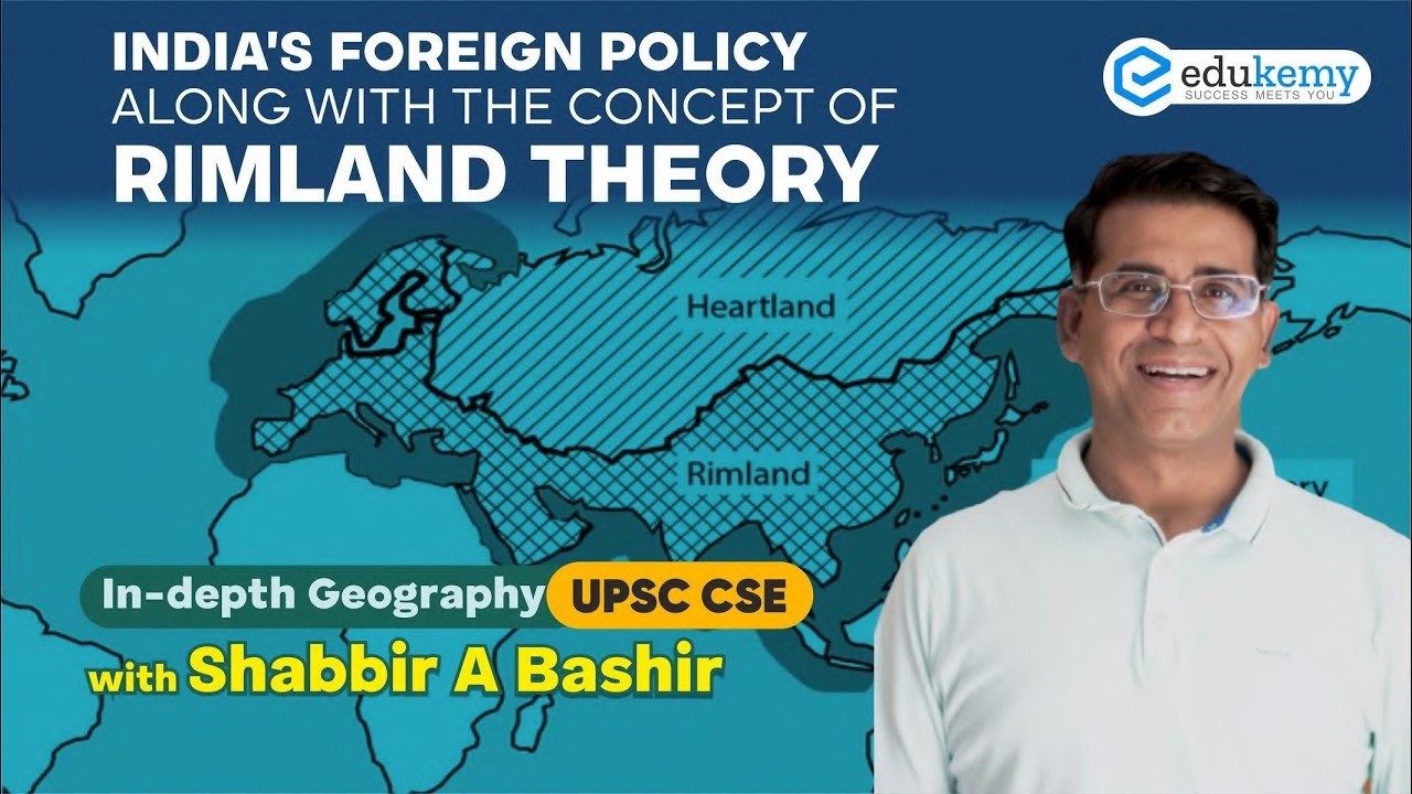 Rimland Eurasian periphery Population concentration Industrial concentration Resource access Ports and sea routes Land–sea connectivit. The strategic significance of the Rimland therefore lies in its position as a zone of interaction between continental and maritime power.
2. Mackinder’s Dictum versus Spykman’s Dictum
The theoretical difference becomes clearer when their famous geopolitical maxims are compared. Mackinder “Who rules East Europe commands the Heartland; who rules the Heartland commands the World-Island; who rules the World-Island commands the world.” Mackinder’s formulation establishes a nested geographical hierarchy in which control over Eastern Europe facilitates control over the Heartland, followed by control over the World-Island and ultimately the wider world. Spykman “Who controls the Rimland rules Eurasia; who rules Eurasia controls the destinies of the world.” Spykman’s formulation changes the strategic pivot. Instead of treating the Heartland as the decisive geographical prize, he places the Rimland at the centre of Eurasian power.
Core Theoretical Contrast 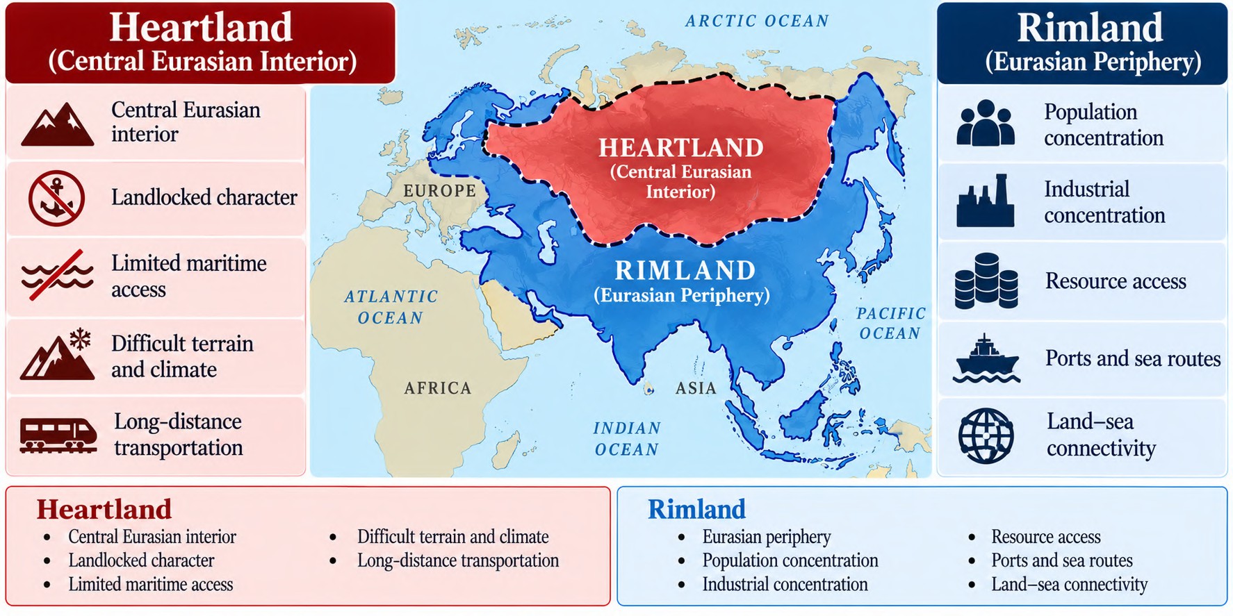 The difference is therefore not simply geographical. It represents two different conceptions of how power is generated and projected across Eurasia.
Strategic Imperative
For Spykman, the greatest danger to the United States would arise if a single hostile power established dominance over the Eurasian Rimland. Such a power could potentially combine the enormous population, resources and industrial capacity of Eurasia with extensive access to the surrounding seas. The strategic implication was therefore the prevention of Eurasian consolidation under a single hostile hegemon. Spykman’s central strategic concern was the balance of power along the Eurasian periphery. The objective was not necessarily to control the entire Rimland directly, but to prevent its consolidation under a hostile power capable of combining continental resources with maritime access.
3. Why is the Rimland Strategically Powerful?
Spykman’s argument rests on the idea that national power is closely associated with the concentration of people, resources, industry and connectivity. These assets are disproportionately concentrated in the Eurasian peripheral regions. The strategic importance of the Rimland can therefore be understood through four major foundations:
3.1 Population Base: “Power Comes from People”
The Rimland contains some of the world’s most densely populated regions. Population concentration provides a large reservoir of human capital, labour, military manpower and markets. This gives Rimland regions a structural advantage over the sparsely populated Heartland. Population is not merely a demographic variable; it can become a source of economic production, military mobilisation and political influence.
Keyword chain: High Population Density | Human Capital | Labour | Military Manpower | Large Markets
3.2 Resource Wealth
The Rimland possesses substantial agricultural and mineral resources. More importantly, many of these resources are located within or close to areas of relatively high population and economic activity. This creates the possibility of combining resource availability with productive capacity, reducing the strategic distance between extraction, production and consumption.
Keyword chain: Resources + Population + Markets = Strategic Economic Potential
3.3 Industrial Infrastructure
The Rimland contains major concentrations of manufacturing, factories, transportation networks, cities and economic infrastructure. Industrialisation converts geographical resources into economic and military power. A region possessing raw materials but lacking industrial infrastructure cannot automatically translate resource wealth into geopolitical influence. The Rimland’s significance lies in the spatial concentration of productive capacity. The combination of urbanisation, industrialisation and transportation networks enables faster mobilisation of economic and military resources. Industrial Geography of Power Raw Materials Agricultural Production Industrial Infrastructure Urban Centres Transportation Networks Economic and Military Capacity
3.4 Maritime Connectivity
The fourth major advantage is maritime connectivity. Rimland regions possess extensive coastlines, ports and access to major maritime routes. Maritime access facilitates:
- International trade
- Movement of resources
- Naval operations
- Military mobility
- Commercial connectivity
- Access to global markets
This gives Rimland states an important advantage over the relatively landlocked Heartland. The decisive characteristic is therefore not simply possession of a coastline, but the ability to combine maritime connectivity with continental depth. The Rimland’s strategic advantage emerges from the concentration and interaction of four assets: population, resources, industry and maritime connectivity. Its power comes not from any single factor, but from their spatial combination.
4. Spykman’s Critique of the Heartland
Spykman’s challenge to Mackinder becomes clearer when the physical and economic limitations of the Heartland are considered. The Heartland possesses significant mineral resources and continental depth, but geographical possession of resources does not automatically translate into effective geopolitical power. The ability to exploit resources depends upon population, infrastructure, capital and connectivity.
Climatic and Demographic Constraints
Large portions of the Heartland historically experienced extremely cold climatic conditions, harsh environments and relatively low population density. Such conditions constrained settlement, agricultural productivity and the concentration of economic activity. Thus, despite its enormous geographical extent, the Heartland did not necessarily possess the same population–industry–market concentration found in many Rimland regions.
Resource Accessibility Problem
The Heartland’s mineral wealth could also face an important accessibility constraint. Resources located in remote regions require substantial investment in:
Extraction infrastructure + Transportation infrastructure + Capital + Energy
before they can be converted into usable economic power. The strategic problem therefore becomes one of distance and transport costs. Vast continental distances can create significant logistical challenges in moving raw materials, manufactured goods and military resources.
Transport Bottlenecks
The Heartland’s landlocked character creates additional challenges because strategic mobility depends heavily upon overland transportation networks. By contrast, maritime transportation allows large volumes of goods and resources to move across considerable distances at relatively lower transport costs. Thus, Spykman’s criticism can be expressed through a fundamental geographical contrast: 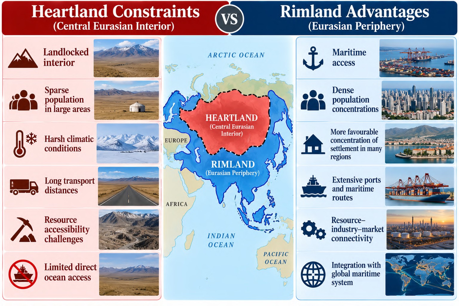
5. Political Fragmentation of the Rimland
Another important distinction is the political structure of the two regions. Historically, much of the Heartland could be consolidated under a large continental political power, particularly the Russian Empire and later the Soviet Union. Its vast territorial expanse could therefore be organised through a relatively centralised continental state. The Rimland, in contrast, consisted of multiple political centres with competing interests. Western Europe, Turkey, Iran, India, China and other regional powers represented different centres of economic, political and strategic power. This political diversity created a balance-of-power environment in which no single actor could easily dominate the entire Eurasian periphery.
Heartland Large territorial expanse Continental consolidation Centralised power Rimland Multiple states Competing regional interests Balance of power External maritime involvement The Rimland’s political fragmentation therefore became strategically significant because control over one portion of the periphery did not automatically translate into control over the entire Eurasian system.
6. Analytical Framework: Why Rimland Matters
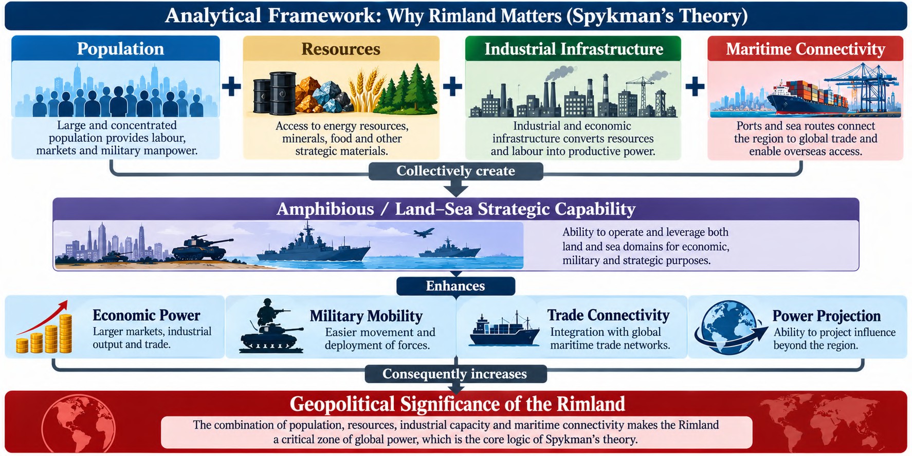 Mackinder asks:
Who controls the Eurasian interior? Spykman asks: Who controls the Eurasian periphery? The shift from Heartland to Rimland is therefore a shift from viewing world power primarily through continental territorial control to understanding the importance of population concentration, industrial capacity, maritime connectivity and the interaction between land and sea power.
Regional Case Studies & US Containment Policy
Spykman’s Rimland Theory becomes particularly useful when applied to post-World War II strategic behaviour. The theory suggests that control, influence or denial of strategic access across the Eurasian periphery can shape the wider balance of power. Western Europe, West Asia, the Indian Ocean and East Asia therefore emerge as interconnected theatres of geopolitical competition.
1. Western Europe: Post-WWII Reconstruction & Containment
Western Europe as the Atlantic Rimland After World War II, Western Europe represented one of the most strategically important sections of the Eurasian Rimland. However, the region had suffered extensive physical destruction, industrial disruption, unemployment, trade dislocation and political instability.  The strategic concern for the United States was that prolonged economic and political instability could create favourable conditions for the expansion of Soviet influence. Thus, the reconstruction of Western Europe became simultaneously an economic project and a geopolitical containment strategy.

Post-War Vulnerability
War devastation
↓
Destroyed infrastructure + industrial disruption
↓
Unemployment + economic instability
↓
Political vulnerability
↓
Possibility of expanding Soviet influence
The US response therefore operated simultaneously through economic assistance, collective security and political reconciliation.
Marshall Plan: Economic Containment
The Marshall Plan represented the economic pillar of American strategy. The United States committed approximately $13.3 billion in post-war assistance for European recovery. Its importance extended beyond financial assistance. Economic reconstruction aimed to restore:
- Industrial production
- Trade
- Employment
- Infrastructure
- Economic confidence
- Political stability
The underlying geopolitical logic was that economic stability could strengthen political resilience against communist expansion.
NATO: Military Containment
Economic reconstruction alone could not guarantee the security of Western Europe. The second pillar was collective defence. The establishment of NATO created a formal security framework in which an attack on one member could be treated as a concern for the alliance as a whole. Thus, the Western European Rimland was reinforced through: Economic Integration + Collective Defence
This transformed Western Europe from a vulnerable post-war region into a more coordinated strategic and military bloc.
Franco-German Reconciliation: Political Stabilisation
A third dimension was the transformation of historically antagonistic European relations, particularly between France and West Germany. The resolution of long-standing disputes over territory and resources, including the historically contested Alsace-Lorraine region and coal-producing areas, contributed to European political stabilisation. The broader strategic logic was crucial:
Former rivals → economic cooperation → political integration → collective security
The reduction of intra-European conflict strengthened the Western European Rimland as a collective geopolitical unit.
Germany: The Rimland Divided
The division of Germany provides a particularly clear illustration of Cold War geopolitical competition. 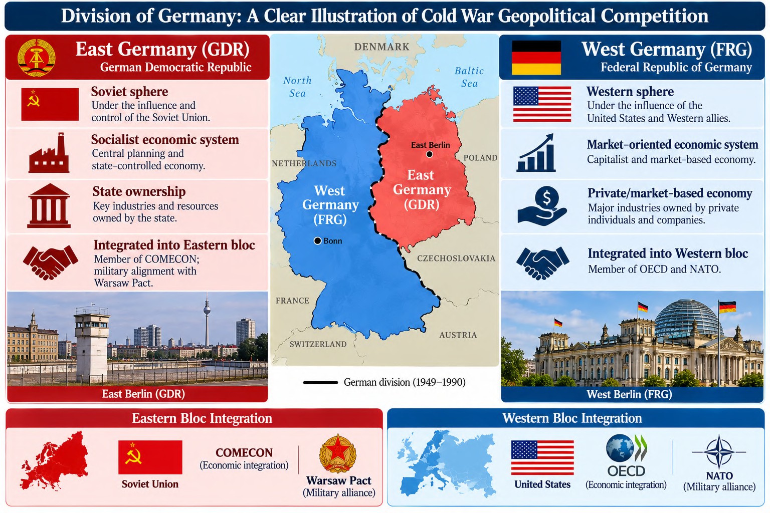 Germany, therefore, became a geopolitical boundary between competing ideological and strategic systems. Its division illustrates how the Eurasian Rimland became a zone of contestation between Soviet continental power and Western maritime-oriented power. The Western European case demonstrates the practical application of Rimland logic: economic reconstruction + collective defence + political integration helped prevent Western Europe from falling under Soviet strategic dominance.
2. Middle East/West Asia: Chokepoints, Energy & Strategic Leverage
West Asia as a Geopolitical Bridge
The Middle East / West Asia occupies a distinctive position within the Rimland because it combines continental connectivity, energy resources and maritime chokepoints. The region connects: Europe ↔ Asia ↔ Africa and simultaneously connects:
Land Power ↔ Maritime Power
This makes West Asia a classic example of geographical leverage: control or disruption at a relatively narrow geographical point can produce consequences far beyond the immediate region.
Maritime Chokepoints
Three major strategic nodes are particularly important:
1. Strait of Hormuz
Connects the Persian Gulf with the Gulf of Oman and the Arabian Sea. 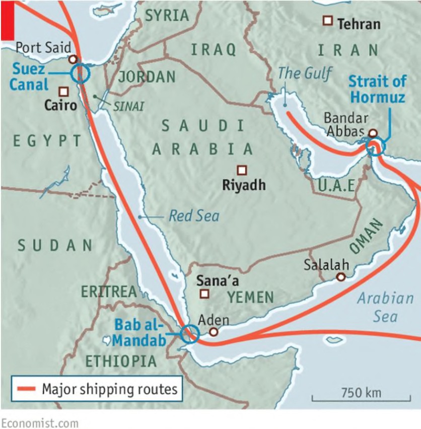 It is one of the world’s most important energy chokepoints. Approximately 20 million barrels of crude oil per day have historically passed through the Strait, making disruption here significant for global energy markets.
2. Bab-el-Mandeb
Connects the Red Sea with the Gulf of Aden. Its importance derives from its position along the maritime route linking the Indian Ocean with the Suez Canal and European markets.
3. Suez Canal
Connects the Mediterranean Sea with the Red Sea and provides a major shortcut between the Indian Ocean and European maritime routes.
Suez Crisis, 1956: Control of a Strategic Node
The 1956 Suez Crisis illustrates the geopolitical significance of maritime chokepoints. Egyptian President Gamal Abdel Nasser nationalised the Suez Canal, challenging the existing British and French position over the strategically important waterway. 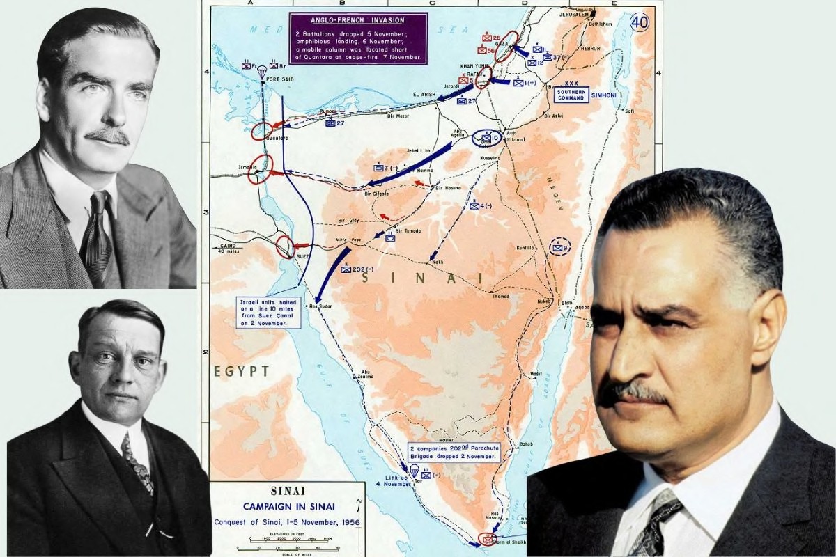 Britain, France and Israel subsequently launched military action against Egypt. The episode demonstrates an important Rimland principle: A geographically narrow transit corridor can possess strategic importance disproportionate to its physical size. Control over the Suez route meant influence over a major Europe–Asia maritime connection.
4. Djibouti: Chokepoint Geopolitics
Djibouti, located near the Bab-el-Mandeb, occupies a strategically valuable position. 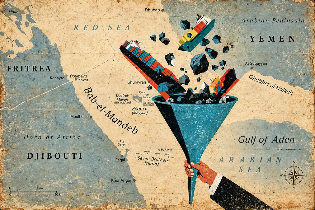 Its geographical location has encouraged the establishment of military facilities by external powers, including the United States, China and France.
This creates a classic Rimland situation:
Strategic Location → Foreign Military Presence → Control / Surveillance of Maritime Routes → Regional Strategic Influence
For Djibouti itself, foreign military installations also generate economic revenue, although the country simultaneously remains exposed to wider regional instability.
5. Iran: Regional Power & Maritime Leverage
Iran’s geographical position gives it substantial strategic leverage over the Persian Gulf and Strait of Hormuz. Iran has periodically threatened the possibility of disrupting or closing the Strait, demonstrating how a state located near a major chokepoint can derive strategic leverage from geography. Its broader regional competition with the United States and Israel also illustrates the interaction between:
Regional Power Projection + Chokepoint Geography + Proxy Networks
Yemen & Bab-el-Mandeb: Proxy Conflict and Global Trade
The Houthi movement in Yemen has become relevant to the geopolitics of the Bab-el-Mandeb and Red Sea. Iran has provided varying forms of support to the Houthis, while the Houthis have conducted attacks affecting maritime traffic. 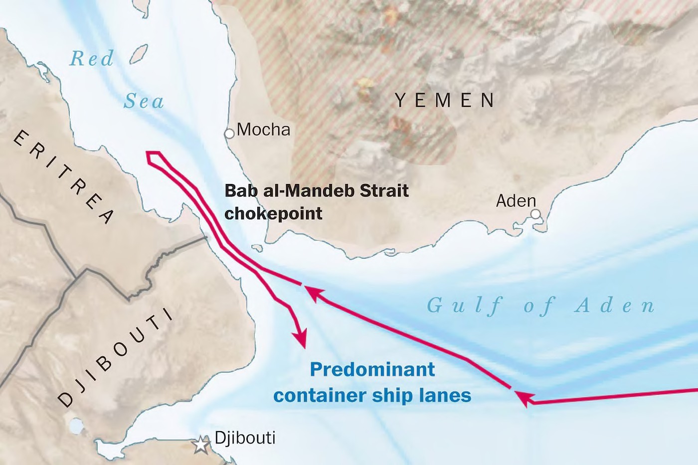 The strategic significance comes from the location: Any sustained disruption can force commercial vessels to consider alternative routes around the Cape of Good Hope, increasing:
- Voyage distance
- Fuel consumption
- Insurance costs
- Shipping costs
- Delivery times
These costs can subsequently affect import prices and inflationary pressures. West Asia demonstrates that geographical chokepoints can convert location into strategic leverage. Hormuz influences energy flows, while Bab-el-Mandeb and Suez influence the movement of goods between the Indian Ocean and European markets.
India & the Indian Ocean Region, India as a Rimland Power
India occupies a distinctive position within Spykman’s Rimland because of its peninsular geography, extending deep into the Indian Ocean. Its geographical position provides access to:
- Arabian Sea
- Bay of Bengal
- Western Indian Ocean
- Eastern Indian Ocean
- Major SLOCs connecting Europe, West Asia and East Asia
India, therefore, possesses both continental depth and maritime reach.
1. Island Territories as Strategic Assets
India’s two major island groups provide important forward positions. 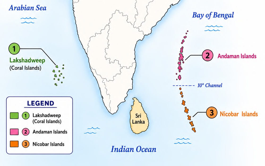
Andaman & Nicobar Islands
Located close to the eastern entrance of the Indian Ocean and near the Strait of Malacca, the islands provide significant opportunities for:
Maritime Surveillance + Naval Deployment + SLOC Monitoring
Their location allows India to monitor important maritime traffic moving between the Indian Ocean and Southeast Asia.
Lakshadweep
Located in the Arabian Sea, Lakshadweep contributes to India’s ability to maintain maritime awareness across the western Indian Ocean.
2. India–US Strategic Convergence
The growing strategic relationship between India and the United States can also be interpreted through Rimland geopolitics. 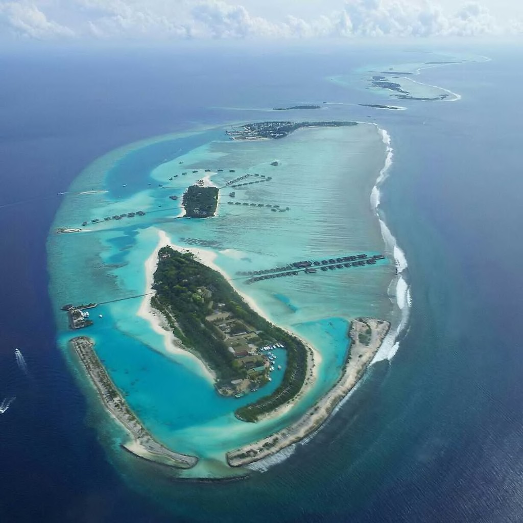 The United States seeks a favourable balance of power in the Indo-Pacific, while India seeks to protect its maritime interests and maintain strategic autonomy. This has produced increasing cooperation in:
Maritime Security + Logistics + Naval Exercises + Intelligence/Information Sharing
LEMOA, 2016
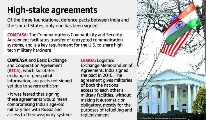 The Logistics Exchange Memorandum of Agreement (LEMOA), signed in 2016, established a framework for reciprocal access to designated military facilities for refuelling and logistics support. Its significance lies less in permanent basing and more in operational interoperability and logistical reach.
Chabahar: Strategic Connectivity
India’s involvement in Chabahar Port, Iran, is important because it provides an alternative connectivity route towards Afghanistan and Central Asia, bypassing Pakistan. 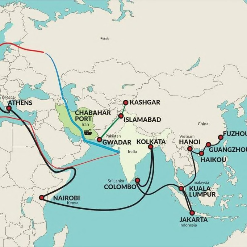 The port therefore has both:
Economic Connectivity and Geopolitical Significance The United States has, at different points, provided sanctions-related accommodation for India’s Chabahar engagement because of the port’s strategic importance.
India’s Maritime Initiatives
Project Mausam
Focuses on India’s historical and contemporary maritime cultural and commercial connections across the Indian Ocean region. It reflects India’s attempt to strengthen its Indian Ocean identity and maritime partnerships.
3. Great Nicobar Project
The development of strategic infrastructure in the Great Nicobar region is significant because of the island’s location near major maritime routes connecting the Indian Ocean and Southeast Asia. India’s Rimland advantage derives from the interaction of:
Peninsular Location + Island Territories + Maritime Reach + Strategic Partnerships 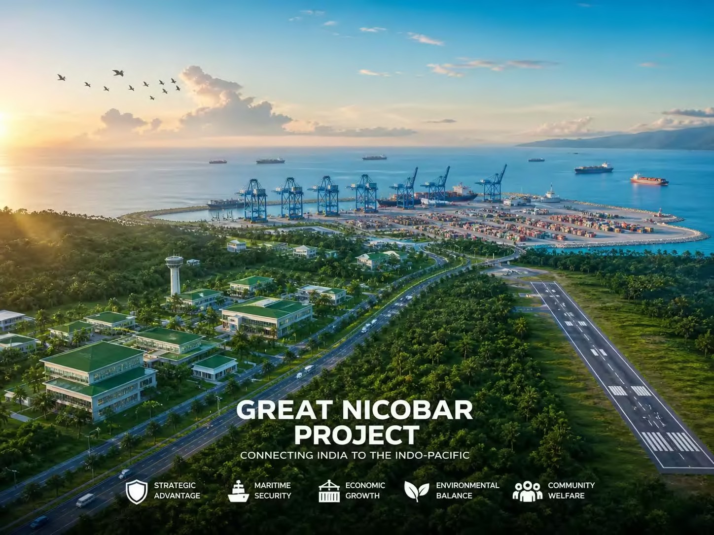
4. China’s “String of Pearls”
India’s maritime strategic concerns are frequently discussed through the concept of China’s “String of Pearls”, referring to a network of Chinese commercial, infrastructure and strategic relationships around the Indian Ocean. 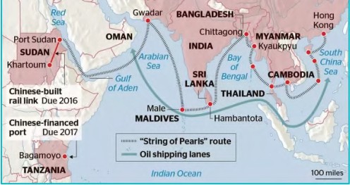 Frequently discussed nodes include:
Gwadar — Pakistan Hambantota — Sri Lanka Chittagong — Bangladesh Kyaukpyu — Myanmar Djibouti — Horn of Africa
Other locations have also been discussed in strategic literature, although the extent to which individual facilities constitute Chinese military bases or a coordinated “encirclement” strategy varies and should not be treated uniformly. The central geographical concern is the possibility of increasing Chinese maritime presence and strategic access around India’s periphery.
Connectivity Constraints: Pipelines
India’s geopolitical position also reveals a paradox: strategic location does not automatically translate into connectivity success. Several major energy projects have faced political, security or economic obstacles.
TAPI Pipeline
Turkmenistan → Afghanistan → Pakistan → India
Potential significance:
Central Asian Gas → South Asian Markets 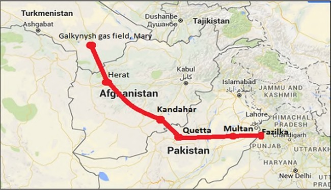 Major constraints include:
- Security instability
- Afghanistan’s political situation
- Pakistan-related concerns
- Regional geopolitical tensions
IPI Pipeline Iran → Pakistan → India
The project encountered problems related to:
- Gas pricing
- Security
- India–Pakistan relations
- US sanctions pressure on Iran
India eventually withdrew from the proposed project.
India–Middle East Deep Sea Pipeline
A proposed Oman–Gujarat undersea energy connection failed to materialise, demonstrating the difficulty of converting strategic geographical possibilities into commercially and politically viable infrastructure.
Transit Connectivity: Opportunities and Bottlenecks
INSTC
The International North–South Transport Corridor (INSTC) seeks to connect India with Iran, Central Asia, Russia and Europe through multimodal transport networks. 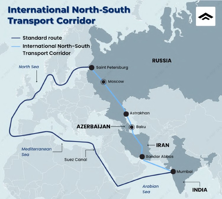 Its strategic value lies in:
Alternative Connectivity + Reduced Transit Dependence + Eurasian Access
However, implementation has remained partial, with infrastructure, sanctions, customs and commercial viability affecting its performance.
IMEEC
The India–Middle East–Europe Economic Corridor (IMEEC) was announced at the 2023 G20 Summit in New Delhi. Its proposed logic is:
India – Middle East – Europe
through a combination of maritime transport, rail connectivity and digital/economic infrastructure. 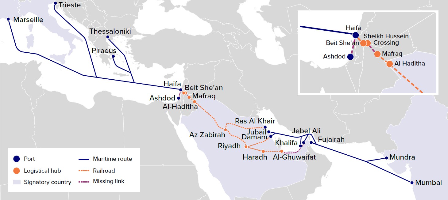 Its implementation has faced geopolitical and regional uncertainties, meaning that the full corridor remains under development rather than a completed transport system.
Kaladan Multi-Modal Project
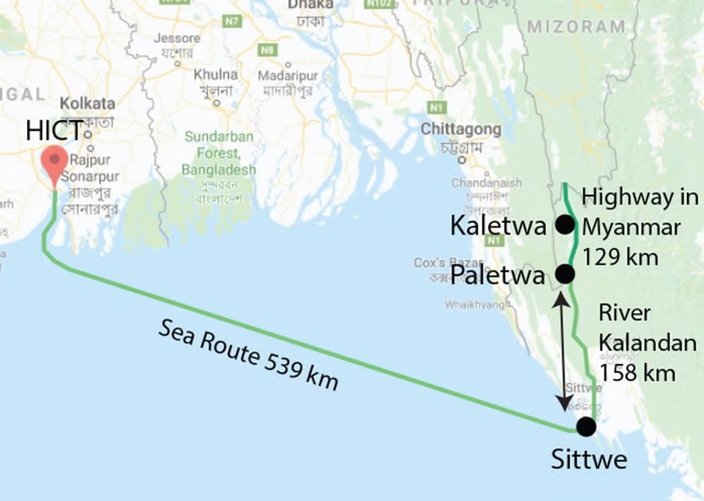 The Kaladan Multi-Modal Transit Transport Project seeks to connect India’s northeastern region with Myanmar’s Sittwe Port and inland waterways/road networks. Its strategic importance is particularly high because it can provide an alternative route for connecting the Northeast with the Bay of Bengal. However, implementation has faced security and construction-related delays.
Chabahar Connectivity
India’s connectivity efforts through Chabahar Port have similarly faced delays involving infrastructure development, railway connectivity and operationalisation.
Connectivity Paradox
Strategic Geography does not automatically produce Strategic Connectivity because projects also depend upon: Politics + Security + Finance + Sanctions + Infrastructure + Regional Stability
India’s position within the Rimland provides considerable maritime and geopolitical leverage, but its ability to convert geography into strategic power depends on overcoming connectivity bottlenecks and regional geopolitical constraints.
China, South China Sea & the Indo-Pacific
China as an Emerging Rimland Power
China represents one of the most important contemporary examples of Rimland power. Its enormous population, industrial base, economic capacity and long coastline give it substantial ability to combine continental and maritime power. However, China’s geographical position also creates a strategic vulnerability: dependence upon maritime energy routes, particularly those passing through the Strait of Malacca. This vulnerability is commonly described as the “Malacca Dilemma.”
1. The Malacca Dilemma
A significant share of China’s imported crude oil travels through the Strait of Malacca, making the narrow maritime passage strategically important for China’s energy security. 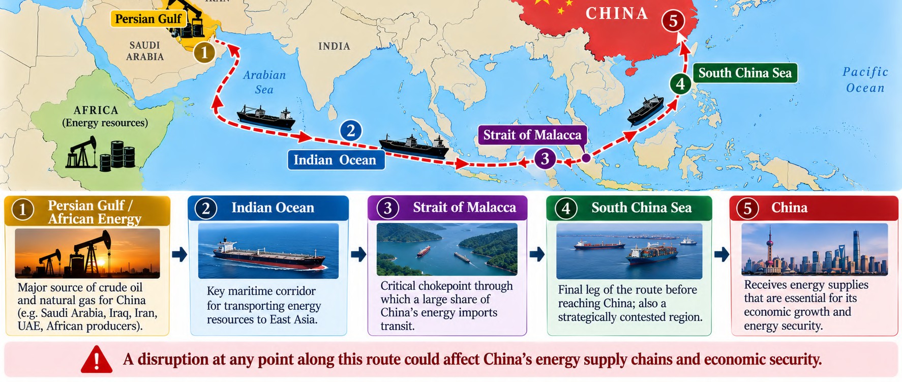 A disruption of this route could potentially affect China’s energy supply chains and economic security. The strategic response has therefore been to develop alternative routes and overland corridors.
China’s Malacca Bypass Strategy
Myanmar Pipeline
Oil arriving on the western coast of Myanmar can be transported through pipelines towards Yunnan, China. This reduces dependence on the entire maritime route through the Malacca Strait.
2. CPEC
The China–Pakistan Economic Corridor (CPEC) connects Gwadar Port on the Arabian Sea with China’s western region, particularly Xinjiang. However, the route does not eliminate China’s maritime dependence because of distance, terrain, capacity and security constraints. 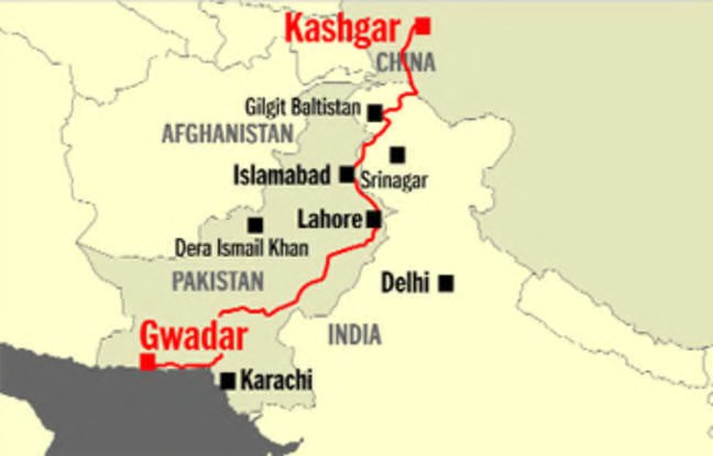
Malaysia ECRL
The East Coast Rail Link (ECRL) provides an alternative east–west transportation connection across Malaysia. Its strategic relevance lies in improving multimodal connectivity and potentially reducing dependence on maritime movement through parts of the Malacca route.
Eurasian Overland Routes
China has also expanded:
- Pipelines through Central Asia
- Kazakhstan energy connections
- Turkmenistan gas links
- Trans-Eurasian railway connectivity
These create a broader strategy of route diversification.
3. South China Sea: Maritime Territorial Assertion
China’s maritime strategy also involves territorial claims in the South China Sea. The most prominent geographical framework is the Nine-Dash Line, within which China asserts extensive maritime rights and interests. The South China Sea contains important:
Sea Lines of Communication + Fishing Grounds + Potential Hydrocarbon Resources + Strategic Maritime Space Consequently, territorial disputes have significant geopolitical implications.
Major Disputed Features
Paracel Islands
Disputed primarily between China and Vietnam.
Spratly Islands
Subject to overlapping claims involving several regional states, including China, Vietnam, the Philippines, Malaysia and Brunei.
Scarborough Shoal
A major point of contention between China and the Philippines.
Senkaku Islands
Administered by Japan but disputed by China, which refers to them as the Diaoyu Islands. They lie in the East China Sea rather than the South China Sea. 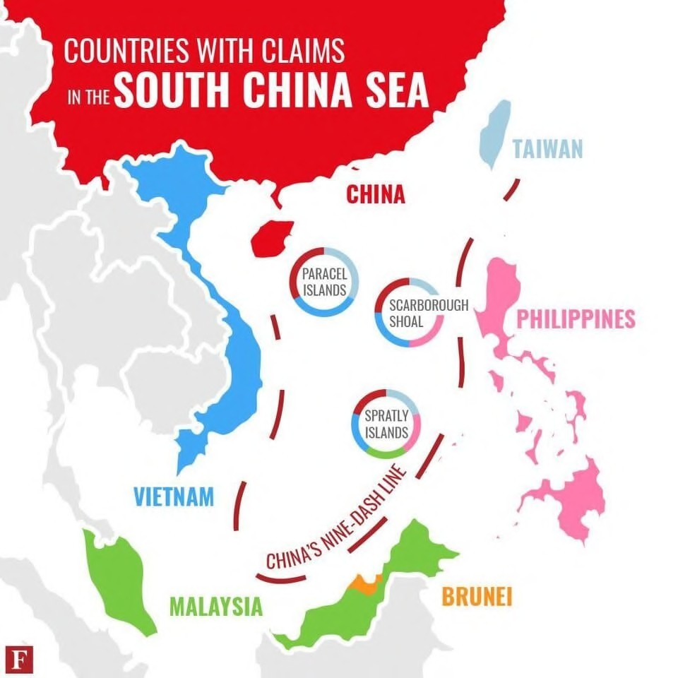
4. US Counter-Containment / Balancing Network
The expansion of Chinese maritime capabilities has encouraged the United States and its partners to strengthen cooperation across the Indo-Pacific. Three important frameworks are:
QUAD
United States + India + Japan + Australia.
Focus areas include: Maritime Security + Strategic Coordination + Indo-Pacific Cooperation
AUKUS
A major focus is advanced defence and security cooperation, particularly Australia’s acquisition of nuclear-powered submarine capability under the broader arrangement.
EDCA: Philippines
The Enhanced Defence Cooperation Agreement (EDCA) provides the United States with expanded access to designated Philippine military facilities. 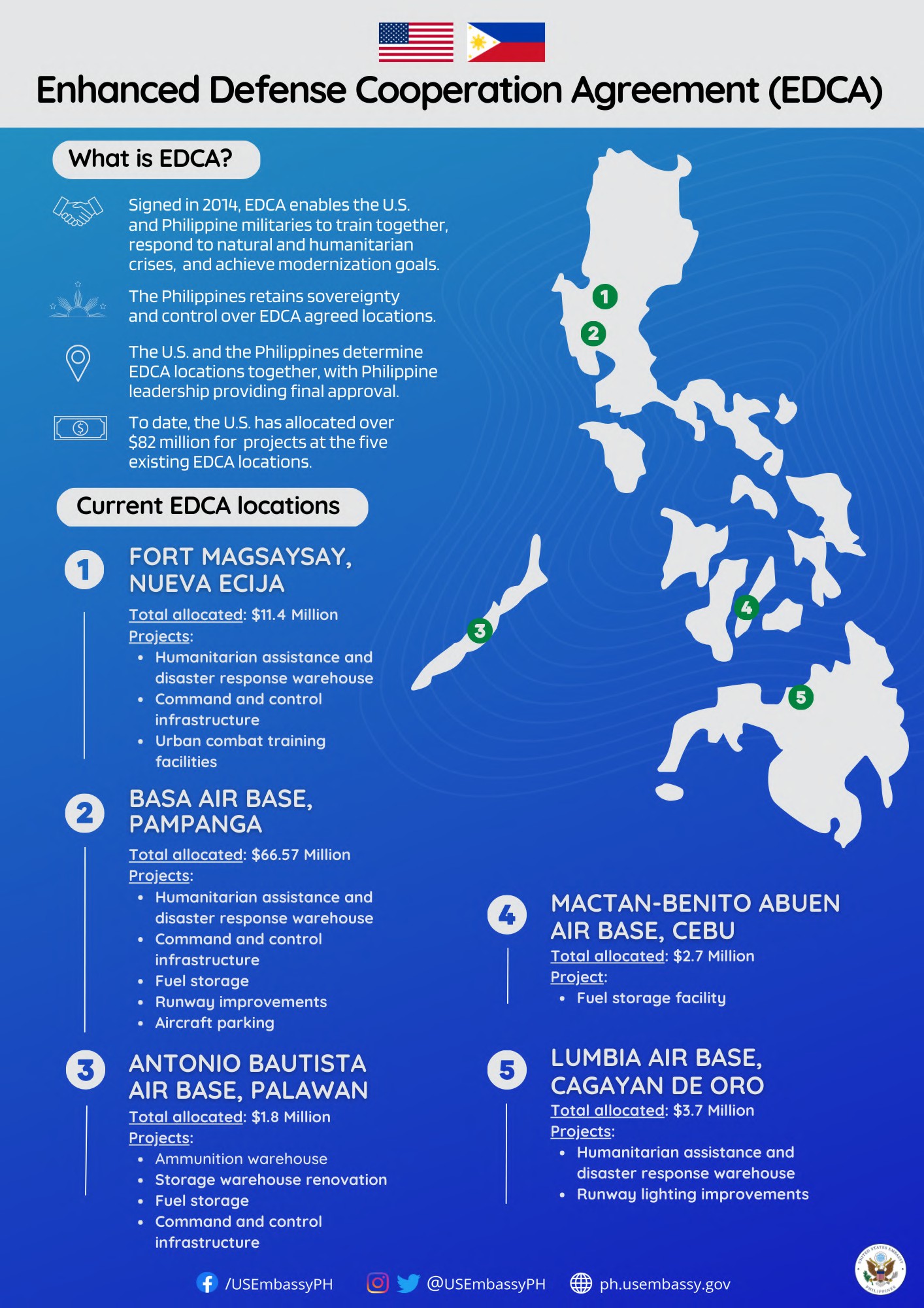 Its strategic significance lies in improving: The Philippines’ geographical position places it close to contested areas of the South China Sea, making it strategically significant to the wider Indo-Pacific balance.
The Contemporary Rimland Security Competition
The China–US strategic competition can therefore be visualised as a competition over: This is essentially a contemporary expression of Spykman’s central proposition: control and influence over the Eurasian maritime periphery have major consequences for the wider balance of power. 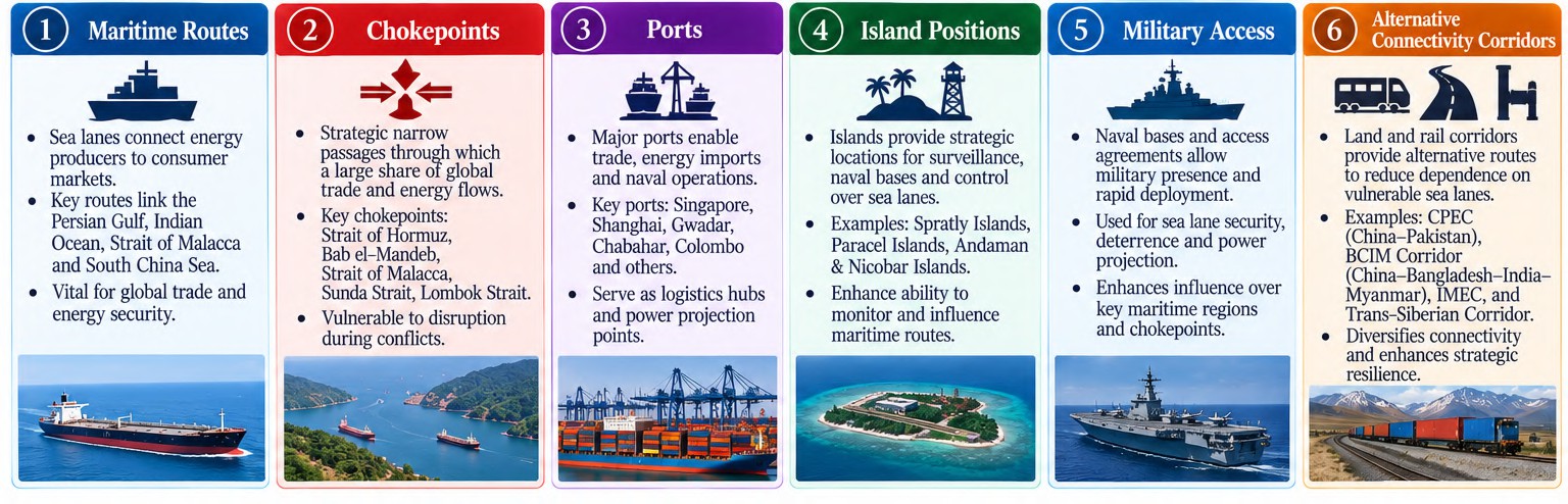
In case you still have your doubts, contact us on 9773890604
Enrol in Geography Optional by Shabbir Sir: Here
Enrol in One-on-One Personalised Mentorship: Here
Enrol in GS Mentorship Program: Here
Enrol in GS Mains Mentorship Program: Here
Explore One Integrated Platform for UPSC Prep: Yooki
Visit our YouTube Channel: here