Indian mapping is pivotal in UPSC Geography, offering a comprehensive understanding of the diverse geographical features that define the Indian subcontinent. Aspirants preparing for the UPSC examination delve into the intricacies of India’s cartographic landscape, exploring the topographical, climatic, and demographic nuances through detailed maps. The study of Indian mapping not only aids in grasping the geographical dimensions of the country but also provides insights into historical, economic, and socio-cultural facets crucial for a holistic comprehension of India’s geographic diversity. From the rugged terrains of the Himalayas to the coastal plains, arid deserts, and fertile river valleys, the cartographic representation becomes a visual gateway for aspirants aiming to navigate through the intricacies of the UPSC Geography syllabus and cultivate a nuanced understanding of the Indian geographical canvas.
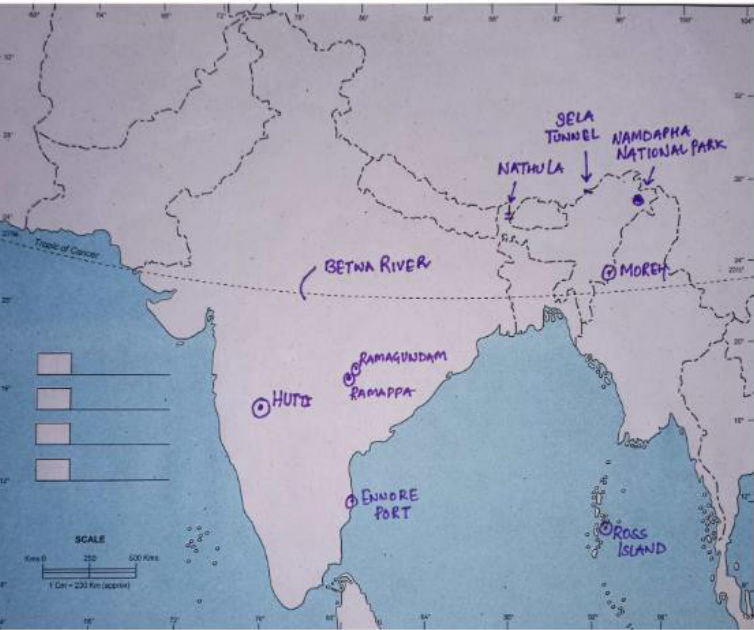
Q: On the outline map of India provided to you, mark the location of all of the following. Write in your QCA Booklet the significance of these locations, whether physical/commercial/economic/ ecological/ environmental/cultural, in not more than 30 words for each entry.
- Nathula
- Hutti
- Ross Island
- Moreh
- Ramappa
- Namdapha National Park
- Sela Tunnel
- Ennore Port
- Ramagundam
- Betwa River


- Nathula
- Mountain pass in Sikkim on Dongkya Range that separates Sikkim and the Chumbi Valley, the pass is 52–54 kilometers east of Gangtok, the capital of Sikkim, one of the three passes used between Sikkim and Chumbi Valley other two being Cho la and Jalep la, the Nathu La and Jelep La passes were part of the trade routes of the British Empire during the 19th and early 20th century.
- Hutti
- Census town in Raichur district in the Indian state of Karnataka, famous for gold mining; the area surrounding the gold mines is incorporated as a separate town, the Hatti Gold Mines notified area council, The mines are owned and operated by Hutti Gold Mines Limited, serves as an important growth center.
- Ross Island
- Officially known as Netaji Subhash Chandra Bose Island, it is an island of the Andaman Islands, it belongs to the South Andaman administrative district, 2018 Prime Minister Narendra Modi renamed them as Netaji Subhas Chandra Bose Island, Tropical vegetation with thick evergreen forests, main occupation is fishing and other related employment, famous tourist destination due to beautiful and pristine beaches.
- Moreh
- Border town located on the India–Myanmar border in Tengnoupal district of the Indian state of Manipur plays an important role in India’s Look East Policy, trade and commerce under ASEAN–India Free Trade Area, predominant languages in Moreh are Thadou (a Kuki-Chin language) and Meitei, multi-religious town with Christians getting clear majority, Rainfall is more than 200cm per annum, Tropical evergreen vegetation, main occupation is subsistence farming predominantly slash and burn agriculture.
- Ramappa
- Also known as the Rudreswara temple, is a Kakatiya style Hindu temple dedicated to the Hindu god Shiva, located in Telangana, an inscription in the temple says it was constructed in the year 1213 CE by Recherla Rudra, the temple is named after the sculptor Ramappa, who built it, making it the only temple in India to be named after its craftsman.
- Namdapha National Park
- The park was established in 1983 in Arunachal Pradesh, It is located between the Dapha bum range of the Mishmi Hills and the Patkai range, with more than 1,000 floral and about 1,400 faunal species, it is a biodiversity hotspot in the Eastern Himalayas, the national park harbours the northernmost lowland evergreen rainforests in the world.
- Sela Tunnel
- The Sela Tunnel cuts through the Sela–Charbela ridge, which separates the Tawang district from the West Kameng district, it is located a few kilometers to the west of the Sela Pass, under construction road tunnel at 3,000 metres which will ensure all-weather connectivity between Guwahati in Assam and Tawang in the Indian state of Arunachal Pradesh, longest bilane tunnel in the world at 13,000 feet.
- Ennore Port
- Kamarajar Port Limited, formerly Ennore Port, is located on the Coromandel Coast, Ennore Port lies on the northeastern corner of the Chennai City of Tamil Nadu State on a flat coastal plain known as the Eastern Coastal Plains, 12th major port of India, and the first port in India which is a public company, originally conceived as a satellite port to the Chennai Port, primarily to handle thermal coal to meet the requirement of Tamil Nadu Electricity Board.
- Ramagundam
- City under municipal corporation in Ramagundam district of the Indian state of Telangana, located on the banks of the Godavari River, It is northeast of the state capital, Hyderabad, experiences dry inland climatic conditions with hot summers and cool winters, experiences the most rainfall in July and August, from the Southwest monsoon, with the highest rainfall being 112mm, situated in the Godavari valley coalfields and has one of the India’s largest thermal power stations in south region under NTPC.
- Betwa River
- A river in Central and Northern India, and a tributary of the Yamuna, it rises in the Vindhya
Range (Raisen) just north of Hoshangabad (Narmadapuram) in Madhya Pradesh, Nearly half of its course, which is not navigable, runs over the Malwa Plateau, the confluence of the Betwa and the Yamuna rivers is in Hamirpur district in Uttar Pradesh, The Betwa River is being linked with the Ken River as a part of the river linking project in Madhya Pradesh.
- A river in Central and Northern India, and a tributary of the Yamuna, it rises in the Vindhya
Contents
In case you still have your doubts, contact us on 9811333901.
For UPSC Prelims Resources, Click here
For Daily Updates and Study Material:
Join our Telegram Channel – Edukemy for IAS
- 1. Learn through Videos – here
- 2. Be Exam Ready by Practicing Daily MCQs – here
- 3. Daily Newsletter – Get all your Current Affairs Covered – here
- 4. Mains Answer Writing Practice – here

