
24 Oct to 10 Nov, 2025
DEFORESTATION AND DEGRADATION
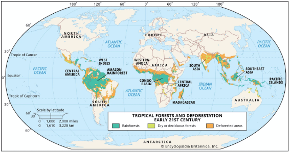
Why in news : Deforestation in the Amazon is an environmental issue that continues to be a major concern across Latin America and beyond.
About :
Deforestation refers to the permanent removal or clearing of forest cover and conversion of land to non-forest uses such as agriculture, mining, settlements, or infrastructure. It alters local and global biogeochemical cycles, reduces carbon sinks, and affects biodiversity and climate regulation.
Global Data and Trends
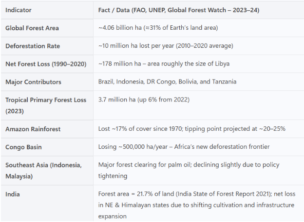
Global Drivers of Deforestation
- Agricultural expansion : Two streams: large-scale commercial (cattle, soy, oil palm) and smallholder/subsistence farming. FAO estimates commercial agriculture caused ~40% and subsistence ~33% of tropical deforestation (2000-2010). Global Forest Review confirms cattle pasture conversion alone drove ~45.1 Mha (2001–2015), far exceeding any single commodity.
- Fuelwood & charcoal (energy poverty): Particularly high in Sub-Saharan Africa, where biomass is a major household fuel; contributes both to deforestation and forest degradation.
- Logging (legal/illegal) & timber/pulp supply chains: Often a gateway: logging roads open forests to later agricultural conversion.
- Infrastructure & settlement (roads, dams, urban growth): Road building increases access and land speculation (e.g., Amazon “arc of deforestation”).
- Mining & extractives (gold, bauxite, coltan) : Localized but intense forest conversion in Amazon and Congo hotspots.
- Fire (often human-set, climate-amplified) : 2024 data show record global forest loss with fires a leading cause in the tropics, supercharged by drought/El Niño
Quick comparative table
|
Region |
Top drivers |
Notable data points |
|
Global |
Agriculture (commercial + subsistence), fuelwood/charcoal, logging, infrastructure, mining, fires |
Commercial agri ~40%, subsistence ~33% of tropical deforestation (2000–10). Cattle pasture 45.1 Mha (2001–15). |
|
Amazon |
Cattle ranching » soy; roads/land-grabbing; fires in drought years |
Brazil’s Pará & Mato Grosso ~5 Mha each to cattle (2001–15). Fire-driven losses spiked in 2024. |
|
Congo Basin |
Smallholder farming, fuelwood/charcoal, selective logging; mining/urban growth rising |
Long-term pattern: subsistence + woodfuel dominate; 2024 record losses in parts of Basin. |
|
Southeast Asia |
Oil palm, pulpwood (acacia), rubber; peat drainage + fires |
Indonesia palm-linked deforestation down to ~32k ha/yr (2018–22), ~18% of the 2008–12 peak. |
Impact of Deforestation
- Hydrological Cycle Disruption : Trees release moisture via evapotranspiration; their removal reduces atmospheric humidity and cloud formation.
Example: Amazon deforestation is projected to reduce regional rainfall by 20–30% by 2050, risking a savannization shift. - Soil Degradation and Desertification: Forest removal exposes soil to direct sunlight and rainfall, causing nutrient leaching, compaction, and erosion.
Example: Madagascar’s deforested hillsides have lost up to 400 tonnes of soil per hectare per year. - Impact on Indigenous Communities and Livelihoods: Forest-dependent populations (≈1.6 billion globally) lose access to food, fuel, and cultural resources.Example: Indigenous tribes like the Yanomami (Brazil) and Orang Asli (Malaysia) face displacement and cultural erosion.Represents a human-environment conflict, central to Cultural Ecology.
- Oceanic and Atmospheric Teleconnections: Large-scale deforestation influences global wind patterns and monsoon systems.Example: Amazon deforestation has been linked to reduced rainfall in the American Midwest and West Africa through atmospheric circulation shifts (Nature Climate Change, 2020).
- Global Climatic Feedback and Tipping Points: Continuous deforestation can push ecosystems beyond recovery thresholds.Example: If 20–25% of the Amazon is deforested, rainfall collapse could trigger irreversible “Amazon Dieback” (IPCC, 2021).
Trees as a Panacea for Climate Change
Carbon Sequestration: The Primary Mechanism
Trees absorb atmospheric carbon dioxide through photosynthesis and store it as biomass in trunks, roots, and soil.
- Amazon Rainforest is often called the “Lungs of the Earth”, storing ~100 billion tonnes of carbon.
- India’s Forest Survey Report (FSI, 2021): Forests and trees outside forests in India store 7,124 million tonnes of carbon, equivalent to 26.14 billion tonnes of CO₂ sequestration potential.
Climate Regulation and Albedo Effect
- Tree cover influences the surface albedo and evapotranspiration, regulating local and regional temperatures.
- Boreal forests in Siberia and Canada reduce surface heating by increasing moisture recycling, thereby moderating the Arctic climate.
- Urban Impact: Urban trees can reduce local temperature by 2–8°C, mitigating heat island effects (World Bank, 2020).
Biodiversity and Ecosystem Resilience
- Trees provide habitats for 80% of terrestrial biodiversity, which supports ecosystem adaptation to climate change.
- Restoration of Degraded Dryland Forests in Rajasthan (Aravalli Green Wall Project) enhances biodiversity and desert resilience.
- Fact: Biodiverse forests are 40% more effective in carbon storage than monoculture plantations (Nature, 2019).
Urban Forestry and Climate Adaptation
- Urban forestry mitigates pollution and enhances microclimatic comfort.
- Singapore’s “City in a Garden” model increased canopy cover to ~47%, reducing city-wide CO₂ footprint.
Major Global Initiatives and Programmes
(a) REDD+ (Reducing Emissions from Deforestation and Forest Degradation)
- Launched under UNFCCC in 2008.
- Provides financial incentives to developing countries for reducing forest loss and enhancing carbon stocks.
- Example:
- Brazil reduced Amazon deforestation by ~70% (2004–2014) under REDD+ projects.
- India implemented pilot REDD+ in Madhya Pradesh and Mizoram.
Great Green Wall Initiative (GGWI, 2007)
- Africa-led movement to restore degraded land across the Sahel region (from Senegal to Djibouti, ~8,000 km).
- Objective: Prevent desert expansion, improve food security, and promote sustainable livelihoods.
- Progress: Over 20 million hectares restored and 350,000 jobs created (UNCCD, 2023).
AFR100 (African Forest Landscape Restoration Initiative, 2015)
- Regional offshoot of the Bonn Challenge.
- Aims to restore 100 million hectares of degraded African landscapes by 2030.
- Supported by the African Union, World Resources Institute, and World Bank.
Forest Landscape Restoration (FLR) Approach
- Promotes mosaic restoration, balancing biodiversity, agriculture, and livelihood.
- Applied in Latin America’s 20x20 Initiative (2014) to restore 20 million hectares by 2020, now scaled up.
Role of International Organizations and Funding Mechanisms
- FAO: Provides technical assistance via Forest and Landscape Restoration Mechanism (FLRM).
- World Bank & GEF (Global Environment Facility): Support projects on sustainable land management and dryland restoration.
- UNEP & UNDP: Support national implementation of UNCCD and REDD+ initiatives.
- Green Climate Fund (GCF): Finances large-scale reforestation and land restoration projects in developing nations.
Conclusion
The global fight against desertification and deforestation represents a synergy of climate, geography, and development. These initiatives show that restoration is not merely ecological — it is spatial, economic, and geopolitical. Achieving Land Degradation Neutrality (LDN) by 2030 requires integrating local stewardship with global frameworks.
Source :
https://indianexpress.com/article/explained/deforestation-state-of-global-forests-10306709/
Where to use :
Paper I ( Geography Optional ) : Environmental Geography
Paper III ( General Studies ) : Environment and Conservation
NAMING OF CYCLONE
Why in news: Cyclone Montha, a severe cyclonic storm, made landfall in Andhra Pradesh, bringing heavy rains, strong winds, and widespread damage across coastal Andhra Pradesh and Odisha, and parts of Tamil Nadu.
About :
Tropical cyclones—also called hurricanes, typhoons or simply cyclones depending on region—are among the most destructive natural hazards. Effective naming and management systems are key to reducing the risk to life and property.
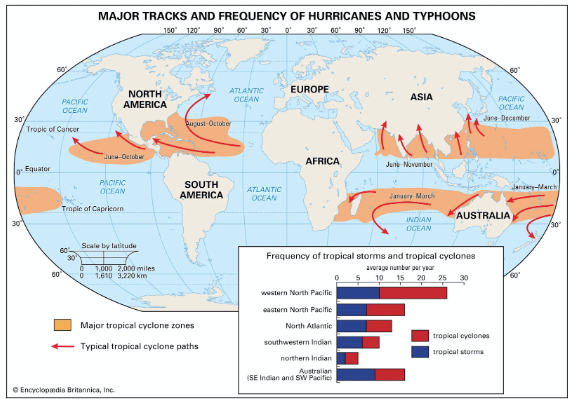
How Tropical Cyclones are Named ?
Why is it important to name cyclones?
- Adopting names for cyclones makes it easier for people to remember
- With a name, it is also easy to identify individual cyclones, create awareness of its development, rapidly disseminate warnings to increase community preparedness and remove confusion where there are multiple cyclonic systems over a region.
What are the guidelines to adopt names of cyclones?
While picking names for cyclones, countries need to follow some rules.
- The proposed name should be neutral to (a) politics and political figures (b) religious believes, (c) cultures and (d) gender
- Name should be chosen in such a way that it does not hurt the sentiments of any group of population over the globe
- It should not be very rude and cruel in nature
- It should be short, easy to pronounce and should not be offensive to any member
- The maximum length of the name will be eight letters
- The proposed name should be provided with its pronunciation and voice over
- The names of tropical cyclones over the north Indian Ocean will not be repeated. Once used, it will cease to be used again.
Panel on Tropical Cyclones
- The World Meteorological Organization (WMO) and the Economic and Social Commission for Asia and the Pacific (ESCAP) jointly established the Panel on Tropical Cyclones (PTC)in 1972 as an intergovernmental body.
- Its membership comprises countries affected by tropical cyclones in the Bay of Bengal and the Arabian Sea.
- The Panel is one of the five regional tropical cyclone bodies established as part of the WMO Tropical Cyclone Programme (TCP) which aims at promoting and coordinating the planning and implementation of measures to mitigate tropical cyclone disasters on a worldwide basis.
- For this purpose, there are Regional Specialized Meteorological Centre (RSMC)- Tropical cyclone and Tropical Cyclone Warning Centres (TCWC) for different regions.
- The main objective of the WMO/ESCAP Panel on Tropical Cyclones is to promote measures to improve tropical cyclone warning systems in the Bay of Bengal and the Arabian Sea.
Who decides names and process
- The World Meteorological Organization (WMO) works with regional bodies to maintain naming lists for each tropical cyclone basin (e.g., North Atlantic, Eastern Pacific, Indian Ocean)
- Each region uses predetermined lists of names submitted and agreed by member countries.
- Example: In the North Atlantic, six lists of names rotate every six years.
- When a cyclone is especially destructive, its name may be “retired” so as not to cause confusion or insensitivity in future.
Regional variations
- The criteria for when a storm is named (wind-speed threshold, classification) differ by basin.
- For the Indian Ocean region (Bay of Bengal & Arabian Sea), the India Meteorological Department (IMD) issues names from a list submitted by countries in the region.
- Naming lists also reflect cultural and linguistic diversity—names are chosen to be familiar to people in the region of impact.
Historical context
- The idea of naming storms began in the early 1900s, but became systematic in the mid-20th century.
- For example, in the North Atlantic, female names were used exclusively until the late 1970s; subsequently, male and female names alternate.
Example of naming mechanism
- In the Atlantic basin: when a tropical storm attains sustained winds of 39 mph (63 km/h) or more, it receives the next name on the list.
- If the list of names for a season is exhausted, an auxiliary list is used.
Where to use :
Paper I ( Geography Optional ) : Climatology and Cyclones.
GREAT ATLANTIC SARGASSUM BELT
Why in news : A massive continent-sized brown belt of sargassum algae has formed in the Atlantic Ocean, known as the Great Atlantic Sargassum Belt (GASB)
About :
A massive stretch of floating brown seaweed now dominates the Atlantic Ocean — known as the Great Atlantic Sargassum Belt (GASB).
- It extends over 8,800 kilometers, from the Gulf of Mexico to the west coast of Africa.
- The belt weighs more than 37 million tonnes, and is so vast it can be seen from space.
Originally confined to the Sargasso Sea — a nutrient-poor, stable part of the North Atlantic — two species of seaweed, Sargassum fluitans and Sargassum natans, have now spread widely across tropical waters.
This floating biomass is not just an ecological curiosity anymore — it’s becoming a serious environmental and socio-economic issue, especially for coastal communities across the Caribbean, Central America, and West Africa.
2. What is Sargassum?
Sargassum is a pelagic (free-floating) macroalgae that drifts naturally in ocean currents.
- It provides shelter for marine organisms like baby turtles and fish.
- However, in excessive amounts, it creates major ecological imbalances.
When these floating mats wash ashore and start decomposing, they release hydrogen sulfide gas — a toxic compound that smells like rotten eggs and causes respiratory problems in humans.
3. The Emerging Crisis
a) Visible Signs of the Problem
- Thick mats of sargassum now blanket beaches from Florida, Belize, and Barbados to Guadeloupe and Ghana.
- These decomposing seaweeds:
- Damage coral reefs by blocking sunlight.
- Clog fishing nets and disrupt marine traffic.
- Discourage tourism — coastal resorts report record visitor declines.
b) Record Size in 2025
According to satellite data (NOAA, 2025), the Great Atlantic Sargassum Belt has reached its largest recorded size.
Scientists say this growth is not an isolated event — it signals deep, long-term changes in ocean circulation and nutrient balance.
4. Oceanic Drivers: The Role of the North Atlantic Oscillation (NAO)
The sudden expansion of sargassum began after an unusual North Atlantic Oscillation (NAO) event in 2010.
a) What is the NAO?
The NAO is a climatic phenomenon that controls wind and ocean current patterns across the North Atlantic. It shifts between high and low pressure differences, influencing:
- Temperature patterns,
- Ocean circulation, and
- Marine nutrient distribution.
b) The 2010 Anomaly
In 2010, a strong NAO anomaly altered wind and current routes, pushing sargassum from the Sargasso Sea into tropical Atlantic waters, where:
- Sunlight is stronger,
- Water is warmer (26–29°C), and
- Nutrient levels are higher.
This provided ideal conditions for sargassum growth. Once it entered tropical currents like the North Equatorial Current, it began circulating across the Atlantic each year.
5. Nutrient Enrichment: The Invisible Fuel Behind the Bloom
While ocean currents explain where sargassum spreads, nutrient pollution explains why it thrives.
a) Sources of Nutrient Runoff
- Agricultural fertilizers (rich in nitrogen and phosphorus) washed off into rivers.
- Industrial waste and urban sewage discharge into coastal waters.
- Atmospheric deposition of airborne nutrients.
b) The Amazon River’s Role
The Amazon River is one of the largest nutrient suppliers. During its annual flood season:
- It releases huge volumes of nutrient-rich freshwater into the Atlantic.
- These nutrients are then carried westward by the South Equatorial Current, feeding the sargassum bloom across thousands of kilometers.
Under these enriched conditions, sargassum biomass can double in just 11 days, according to the Harbor Branch Oceanographic Institute (2025) — a remarkable growth rate that reflects a fundamental change in ocean productivity.
6. Environmental and Socio-economic Impacts
a) Ecological Impacts
- Coral Reef Damage: Thick mats block sunlight and reduce oxygen levels.
- Coastal Hypoxia: Decomposition leads to oxygen depletion, harming fish populations.
- Methane Emissions: Rotting sargassum releases methane and hydrogen sulfide — both potent greenhouse gases.
b) Socio-economic Impacts
- Tourism Losses: Caribbean islands report millions in cleanup costs and reduced tourist arrivals.
- Fisheries Disruption: Nets and propellers get entangled, reducing fishing days and catches.
- Public Health Risks: Hydrogen sulfide exposure causes headaches, nausea, and respiratory issues
7. Monitoring and Management Efforts
a) NOAA’s Coordinated Response
The National Oceanic and Atmospheric Administration (NOAA) has developed a real-time Sargassum Monitoring Program through its Atlantic Oceanographic and Meteorological Laboratory (AOML).
It uses:
- Satellite imagery,
- Ocean sensors, and
- Citizen reporting platforms
to track bloom formation, density, and drift direction.
b) Regional and Local Actions
- Caribbean and Mexican initiatives are exploring the commercial reuse of sargassum:
- Biofuel, fertilizer, animal feed, and eco-bricks.
- Early-warning bulletins and clean-up strategies are now shared across nations through regional cooperation.
c) Research Frontiers
Scientists are studying how decomposing sargassum contributes to greenhouse gas emissions, particularly methane, potentially feeding back into global warming.
9. The Way Forward: A Need for Global Coordination
a) Prevention over Adaptation
While finding industrial uses for sargassum is helpful, scientists warn that adaptation alone will not solve the problem.
b) Key Solutions
- Reduce nutrient runoff from major river systems (e.g., Amazon, Mississippi, Congo).
- Enhance ocean monitoring systems and climate models.
- Regional collaboration through organizations like the Caribbean Environment Programme (CEP).
- Public awareness and sustainable coastal land management.
10. Conclusion
The Great Atlantic Sargassum Belt is a striking reminder that ocean ecosystems are tightly linked to human activities on land and atmospheric changes above.
A single atmospheric anomaly in 2010, combined with decades of nutrient pollution, has reshaped marine geography across the Atlantic basin.
Source :
https://www.bgr.com/2014709/what-is-the-great-atlantic-sargassum-explained/
Where to use :
Paper 1( Geography Optional ) : Oceanography
Whiteholes
Whiteholes : White holes are hypothetical cosmic regions opposite to black holes. Instead of absorbing matter, they theoretically expel it, preventing anything from entering. Predicted by Einstein’s field equations, they represent time-reversed black holes. Though never observed, white holes are important in cosmology for understanding spacetime symmetry, entropy, and theoretical models of wormholes connecting distant parts of the universe.
Rare Earth Magnets
Rare Earth Magnets : Rare earth magnets, made from elements like neodymium and samarium, are extremely strong permanent magnets essential for advanced technologies—electric vehicles, wind turbines, and electronics. Despite their name, rare earth elements are relatively abundant but unevenly distributed, making their extraction geopolitically sensitive. China dominates global production, influencing global supply chains and raising environmental and strategic concerns.
Wildlife Diplomacy
Wildlife Diplomacy : Wildlife diplomacy refers to using wildlife conservation and species protection as instruments of soft power and international cooperation. It includes joint conservation projects, transboundary reserves, and species exchange programs (e.g., China’s panda diplomacy). This form of diplomacy enhances ecological interdependence, fosters goodwill among nations, and promotes environmental peacebuilding, especially in biodiversity-rich regions like South and Southeast Asia.
Cryoturbation
Cryoturbation: Cryoturbation is the mechanical mixing of soil layers due to repeated freezing and thawing in periglacial or tundra environments. This process disrupts soil horizons, redistributes organic matter and minerals, and forms patterned ground. It significantly influences soil formation and geomorphology in cold climates, affecting carbon storage, vegetation growth, and the stability of Arctic landscapes amid climate change.
Trophiccascade
Trophic cascade: A trophic cascade occurs when changes at one trophic level (usually predators) indirectly affect lower levels of the food chain, altering entire ecosystem dynamics. For example, the reintroduction of wolves in Yellowstone reduced deer populations, allowing vegetation recovery and better riverbank stability. Such cascades illustrate the interconnectedness of ecosystems and the ecological importance of top predators in maintaining balance.
SRI CITY SPECIAL ECONOMIC ZONE
Sri City SEZ — located on the Andhra Pradesh–Tamil Nadu border, about 55 km north of Chennai — is one of India’s most strategically planned integrated business cities, exemplifying how infrastructure-led development can drive regional growth.
Export and Investment Data
- Cumulative investment: ₹40,000 crore (as of 2024).
- Exports: Over US$ 1.2 billion annually (2023–24).
- Employment: ~60,000 direct jobs + ~1.2 lakh indirect jobs.
- Countries of Investor Origin: Japan, South Korea, France, Germany, and USA (over 30 nationalities represented).
Functional Linkages and Regional Impacts
a) Economic Impact
- Boosted industrialization in southern Andhra Pradesh, shifting it from an agrarian to a manufacturing base.
- Integrated with Chennai–Bengaluru Industrial Corridor (CBIC) under the National Industrial Corridor Development Programme (NICDP).
- Increased per capita income in the region by ~35% (2010–2020) (Andhra Planning Dept.).
b) Urban and Social Transformation
- Development of Tada–Sullurpet micro-region as a new growth pole, attracting residential townships and service industries.
- Improved road, water, and power infrastructure across surrounding villages.
c) Environmental Management
- Nearly 15% of total land is reserved as green cover and water bodies.
- Use of zero-liquid discharge systems and renewable energy (solar parks).
- Recognized under CII Green Infrastructure Certification (2020).

Where to use ?
Paper I ( Geography Optional ) : Special Economic Zone
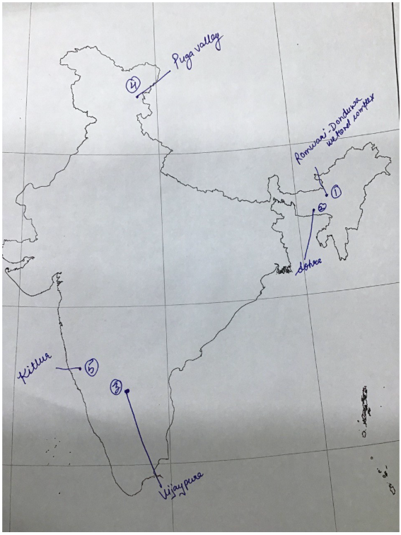
Places in News - 10 November 2025
1. Rowmari–Donduwa Wetland Complex
Why in news: There is a demand for the inclusion of the Rowmari–Donduwa Wetland Complex in Assam as a Ramsar Site, recognizing its remarkable biodiversity and ecological significance.
About :
- Situated within the Laokhowa–Burhachapori Wildlife Sanctuary, Nagaon district, Assam, forming part of the Kaziranga–Orang landscape.
- An interconnected floodplain–marsh system acting as an ecological corridor between Kaziranga and Orang National Parks, supporting wildlife movement and genetic diversity.
- Hosts globally threatened birds, Knob-billed Duck, Lesser Adjutant Stork, Black-necked Stork, Ferruginous Pochard, and Common Pochard.
2. Sohra
Why in news : The Ministry of Development of North Eastern Region (DoNER) laid the foundation stone for the Integrated Sohra Circuit under the Prime Minister’s Development Initiative for North Eastern Region (PM-DevINE) scheme and launched Rs 233 crore worth of DoNER Projects in Meghalaya.
About :
- Cherrapunji also known as Sohra, is a sub-divisional town (Proposed District) in the East Khasi Hills district in the Indian state of Meghalaya. It was the traditional capital of ka hima Sohra (Khasi tribal kingdom).
- Sohra has often been credited as being the wettest place on Earth, but currently, nearby Mawsynram holds that distinction. Sohra still holds the all-time record for the most rainfall in a calendar month and in a year.
- Integrated Sohra Circuit project was developed by the Ministry of DoNER and the Government of Meghalaya with an aim to transform Sohra into a sustainable, multi-day tourism hub promoting local livelihoods.
- The project includes development of Sohra Experience Centre and eco-tourism sites like Nohkalikai Falls, Mawsmai Eco Park, and Wahkaliar Canyon.
3. Vijayapura
Why in news : Minor 3.1 magnitude tremors jolt Karnataka's Vijayapura
About :
- Vijayapur is a town in Devanahalli taluk and Bengaluru North district in the Indian state of Karnataka.
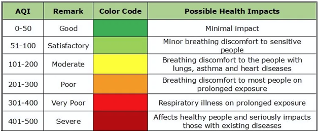
- It is ranked among top 10 Indian cities with the cleanest air and best AQI (Air Quality Index) in 2024.
- Vijayapura is mainly famous for Gol-Gumbaz, Jumma Masjid, Bara Kamaan, Gajanan Temple, Ibrahim Roza,Taj Bawdi, Malik-e-Maidan, Methar Mahal, Gagan Mahal, Jala Manzil, Upli Burj, Shivagiri, Siddeshwar Temple etc.
4. Puga valley
Why in news : India’s First Geothermal Power Project Nears Reality in Ladakh’s Puga Valley.
About :
- It is located in the south-eastern part of Ladakh, about 140-160 km from Leh, and is accessible via the Changthang Valley.
- Puga Valley is rich in minerals like sulfur and borax.
- The geothermal area is situated near the Indus Suture Zone, which marks the boundary where the Indian and Asian tectonic plates collide.
5. Kittur
Why in news : The Government of India marked 200 years of Rani Chennamma’s historic victory at Kittur (1824) with the release of a special Rs 200 commemorative coin celebrating her courage and leadership against British rule.
About :
- Kittur or Kitturu, historically known as Kittoor, is a town and a taluk in the Belagavi district of the Indian state of Karnataka.
- The area is part of the Maidan (plateau) region with black and red loamy soils, suitable for crops like sorghum (jowar), groundnut, and cotton.
- It lies near the Malaprabha River basin, contributing to semi-arid agricultural patterns.
Fortnightly KOSMOS MCQs Practice - 10th November 2025
Q1. With reference to the “Global Cooling Pledge” recently in news, consider the following statements:
1. It is a legally binding agreement under the United Nations Framework Convention on Climate Change (UNFCCC).
2. India is a signatory to the pledge.
Which of the statements given above is/are correct?
- 1 only
- 2 only
- Both 1 and 2
- Neither 1 nor 2
Q2. Consider the following statements regarding the “Project Dolphin” launched recently:
1. It aims to conserve both riverine and marine dolphins in India.
2. The project is implemented by the Ministry of Jal Shakti.
Which of the statements given above is/are correct?
- 1 only
- 2 only
- Both 1 and 2
- Neither 1 nor 2
Q3. With reference to the “Mangrove Initiative for Shoreline Habitats & Tangible Incomes (MISHTI)”, consider the following statements:
1. It is a centrally sponsored scheme.
2. The initiative aims to restore mangrove cover in all coastal states of India.
3. It is implemented by the Ministry of Environment, Forest and Climate Change.
Which of the statements given above are correct?
- 1 and 2 only
- 2 and 3 only
- 1 and 3 only
- 1, 2 and 3
Q4. Consider the following statements about the “Global Methane Pledge”:
1. It aims to reduce global methane emissions by at least 30% from 2020 levels by 2030.
2. India is one of the founding members of the pledge.
Which of the statements given above is/are correct?
- 1 only
- 2 only
- Both 1 and 2
- Neither 1 nor 2
Q5. With reference to the “State of India’s Birds Report 2025”, consider the following statements:
1. The report is jointly published by the Ministry of Environment, Forest and Climate Change and BirdLife International.
2. It highlights a significant decline in the population of endemic species.
3. The report recommends urgent habitat restoration measures.
Which of the statements given above are correct?
- 1 and 2 only
- 2 and 3 only
- 1 and 3 only
- 1, 2 and 3
Q6. Consider the following statements regarding the “Green Credit Programme” launched recently:
1. It incentivizes individuals and industries for undertaking environment-friendly actions.
2. The credits earned can be traded in a national marketplace.
Which of the statements given above is/are correct?
- 1 only
- 2 only
- Both 1 and 2
- Neither 1 nor 2
Q7. With reference to the “International Whaling Commission (IWC)”, consider the following statements:
1. It is an intergovernmental body established under the International Convention for the Regulation of Whaling.
2. India is a member of the IWC.
3. The IWC has imposed a moratorium on commercial whaling since 1986.
Which of the statements given above are correct?
- 1 and 2 only
- 2 and 3 only
- 1 and 3 only
- 1, 2 and 3
Q8. Consider the following statements regarding “Plastic Waste Management (Amendment) Rules, 2024”:
1. The rules prohibit the manufacture, import, stocking, distribution, sale and use of single-use plastics.
2. The rules introduce Extended Producer Responsibility (EPR) for plastic packaging.
Which of the statements given above is/are correct?
- 1 only
- 2 only
- Both 1 and 2
- Neither 1 nor 2
Q9. With reference to the “Intergovernmental Science-Policy Platform on Biodiversity and Ecosystem Services (IPBES)”, consider the following statements:
1. It is an initiative of the United Nations Environment Programme (UNEP).
2. IPBES assesses the state of biodiversity and ecosystem services globally.
Which of the statements given above is/are correct?
- 1 only
- 2 only
- Both 1 and 2
- Neither 1 nor 2
Q10. Consider the following statements about the “National Clean Air Programme (NCAP)”:
1. It aims to achieve a 40% reduction in particulate matter concentration by 2026 in 131 non-attainment cities.
2. The programme is implemented by the Central Pollution Control Board (CPCB).
3. It is a statutory programme under the Air (Prevention and Control of Pollution) Act, 1981.
Which of the statements given above are correct?
- 1 and 2 only
- 2 and 3 only
- 1 and 3 only
- 1, 2 and 3
Share the article
Edukemy’s Current Affairs Quiz is published with multiple choice questions for UPSC exams
MCQ
Get Latest Updates on Offers, Event dates, and free Mentorship sessions.

Get in touch with our Expert Academic Counsellors 👋
FAQs
Geography Current Affairs focuses on the contemporary issues, events, and developments in the field of geography. It covers recent geographical phenomena, environmental changes, geopolitical shifts, and related news. This differs from regular geography studies which may focus more on foundational concepts, historical contexts, and theoretical frameworks.
Updates are provided regularly to ensure that subscribers stay informed about the latest developments in geography. Typically, updates are provided on a fortnightly basis, depending on the frequency of significant events and changes in the field.
Absolutely. Geography Current Affairs serves as a valuable resource not only for Geography optional but also for GS papers, especially GS Paper 1 (covering Indian Heritage and Culture, History, and Geography of the World and Society) and GS Paper 3 (covering Technology, Economic Development, Biodiversity, Environment, Security, and Disaster Management). It aids in building a holistic understanding of various topics and strengthens answer-writing skills by incorporating contemporary examples and perspectives.
Geography Current Affairs holds immense importance for UPSC preparation, particularly for aspirants opting for Geography optional. It helps candidates stay updated with the latest developments, geographical phenomena, environmental issues, and geopolitical shifts worldwide, aligning them with the dynamic nature of the subject as tested in the UPSC examinations.