13 Nov
Extreme Events and Relationship with Climate Change
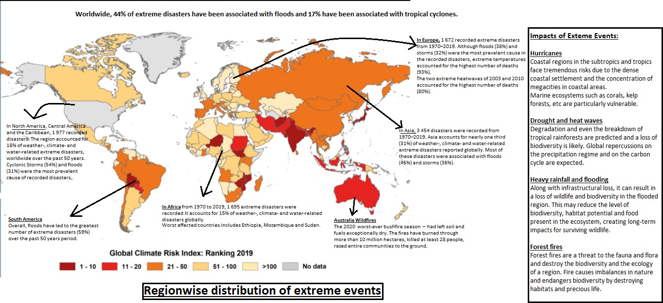
- In news: According to State of the Climate in Asia report, India along with China and Bangladesh recorded most of the extreme event disaster-related displacement globally in 2020.
- Background:
- According to IPCC -AR6, changing climate leads to changes in the frequency, intensity, spatialextent, duration, and timing of weather and climate extremes.
- While many weather and climate extremes are the result of natural climate variability (includingphenomena such as El Niño), and natural decadal or multi-decadal variabilities, it is theanthropogenicactivities which are the driving force in climate change.
- As a consequence,average temperatures have risen by 1.2Ccomparedtopre industrialera. This additional energy is unevenlydistributed and bursts out in extremes events disasters like hurricanes, heat-waves, cloud bursts, droughts etc.
For example: some of the extreme events that have been experienced around the world in 2021 are:
- A heat wave in Canada and adjacent parts of the USA pushed temperatures to nearly 50C in a village in British Columbia.
- Death Valley, California reached 54.4C during one of multiple heat waves in the south-western USA.
- A second successive year of drought in sub-tropical South America reduced the flow of river basins and hit agriculture, transport and energy production.
- Climate change relationship with increasing extreme events:
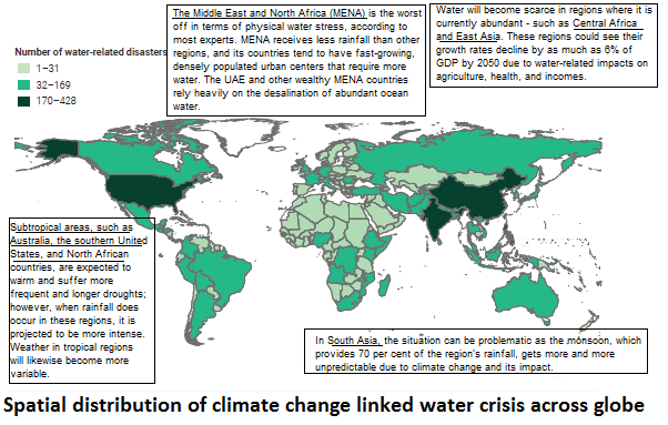
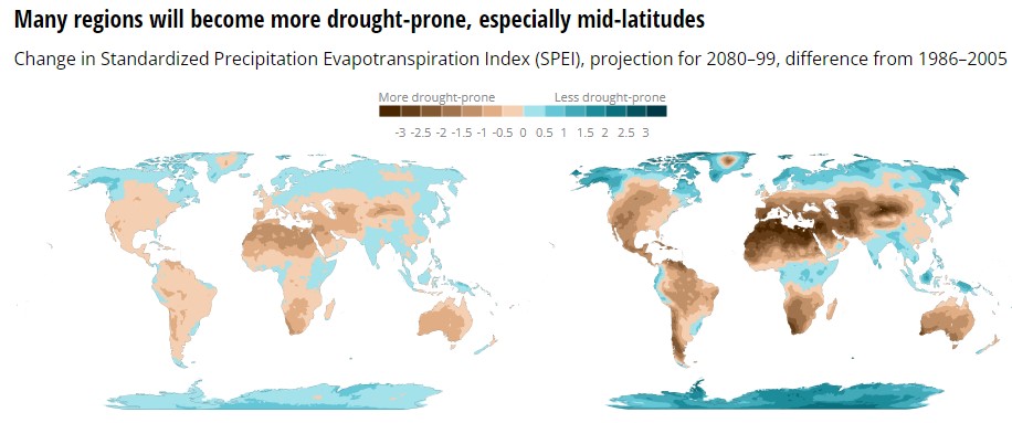
- How climate change contributes to drought: With climate change the equilibrium of water cycle will shift. The Standardized Precipitation-Evapotranspiration Index, indicate more drought-prone conditions. Large regions of the planet, especially the mid-latitudes, are expected to become more drought-prone by 2100.
Climate change is also altering the timing of water availability.
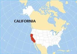
Case study: California droughts
California experienced a particularly drawn-out drought from December 2011 to March 2019. And 2020 saw widespread, prolonged drought that was exacerbated by heat waves in more than a dozen Western and Central states. The intense drought and heat combined to wither vegetation, intensified Western wildfires that burned record acreage.
-
- Extreme Precipitation and Climate Change:
As the planet continues to warm, warmer air can hold more water vapor. For each degree of warming, the air’s capacity for water vapor goes up by about 7 percent. An atmosphere with more moisture can produce more intense precipitation events.
Warming increases precipitation variability, meaning there will be more periods of both extreme precipitation and drought. This creates the need for expanded water storage during drought years and increased risk of flooding and dam failure during periods of extreme precipitation.
- Shift of Hurricanespolewards:Areas affected by hurricanes are shifting pole-ward. This is associated with expanding tropics due to higher global average temperatures.
- Warmer sea surface temperaturescould intensify tropical storm wind speeds, as more low pressures will be generated and phenomena of rapid intensification will become more common. NOAA has suggested that an increase in Category 4 and 5 hurricanes is likely, with hurricane wind speeds increasing by up to 10 percent.
For example: recent storms such as Florence in 2018 and Imelda in 2019demonstrate the devastating floods that can be triggered by these high-rain hurricanes.
- Sea level riseis likely to make future coastal storms, including hurricanes, more damaging. Globally averaged, sea level of rise by 1-4 feet in low and moderate emissions scenarios during this century, which is expected to amplify coastal storm surge.
Example: Recently, Hurricane Ida made landfall in Louisiana, US- an extremely dangerous Category 4 storm and one of the most powerful storms ever to hit the US.
- Wildfires and climate change:Wildfire risk depends on a number of factors, including temperature, soil moisture, and the presence of trees, shrubs, and other potential fuel. All these factors have strong direct or indirect ties to climate variability and climate change. Changes in climate create warmer, drier conditions. Increased drought, and a longer fire season are boosting these increases in wildfire risk.
For example:For much of the U.S. West, projections show that an average annual 1 degree C temperature increase would increase the median burned area per year as much as 600 percent in some types of forests.
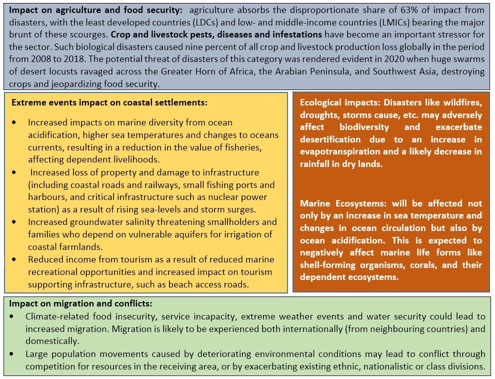
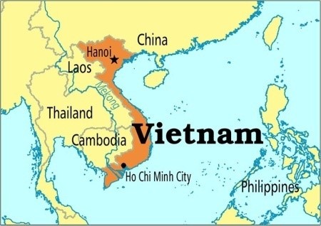
- Case study: The Impact of Extreme Events and Climate Change on Agricultural and Fishery Enterprises in Central Vietnam
According to the Plan for implementing the National Strategy for Prevention, Control and Mitigate the Impacts of Natural Disasters, 2020, annual losses caused by extreme weather events can occupy about 1.5% GDP, especially from agriculture because:
- The increase of the temperature or the unusual fluctuations of the weather and climate change affect agricultural production activities even adversely.
- The irregularities of climate cycle not only lead to an increase of diseases, pests and a decrease in crop yields, but also pose other serious risks.
- Water quantity for irrigation has declined, even groundwater source is also seriously decreased. High temperature base leads to water shortages in dry season and threaten forest fires, especially in Gia Lai,Vietnam. Therefore, in the dry season, tens of thousands of cropping hectares such as coffee, pepper, wet rice, and short-term crops in the Central Highlands lack irrigation water seriously which badly affects the yield and productivity of agricultural enterprises.
- Way forward:
- Investing in resilience and disaster risk reduction, especially data gathering and analysis for evidence-informed action
- Holistic responses and cross-sectoral collaboration are key in the disaster response. Countries must adopt a multi-hazard and multi-sectoral systemic risk management approach to anticipate, prevent, prepare for and respond to disaster risk in agriculture. Strategies need to integrate not only natural hazards, but also anthropogenic and biological threats, such as the COVID-19 pandemic, and must be based on an understanding of the systemic nature and interdependencies of risks.
- Substantially increase the availability and access to multi-hazard early warning systems and disaster risk information and assessments to people by 2030.
- Climate change and sustainable development are fundamentally connected: Put in place sustainable development policies and actions that reduce deprivation, alleviate poverty and ease ecosystem degradation while also lowering emissions, reducing climate change impacts and facilitating adaptation.
- Where can we use it : Paper1(Climate change and Environmental geography) and paper 2(Contemporary, Agriculture and Resources)
GS- P1 (Geographical phenomena- climate change), P3 ( Environment).
Links:
Cyclone Gulab: An exceptional Cyclone in the Bay of Bengal
Background:
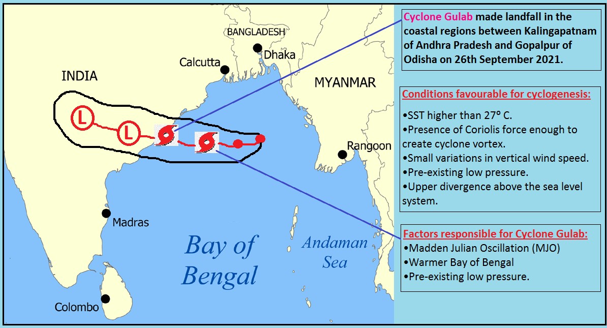
- In the 21st century, Cyclone Gulab is only the third Bay of Bengal cyclone to make landfall in September, during the active monsoon season- when temperatures across the Bay of Bengal are expected to be lower than conducive for cyclone intensification.
- The two other such cyclones have been Cyclone Pyarr, which made landfall in Andhra Pradesh in 2005, and Cyclonic Storm Daye, which hit Odisha in 2018.
How can we call Cyclone Gulab as an exception in the Bay of Bengal?
Typically, tropical cyclones in the North Indian Ocean region (Bay of Bengal and Arabian Sea) develop during the pre-monsoon (April to June) and post monsoon (October to December) periods. But on rare occasions, cyclones do occur in June and September months i.e. during active monsoon season.
Why generally cyclones do not form during active monsoon season?
- Vertical Wind Shear:
Cyclones are less common during the June to September monsoon season, as there are limited or almost no favourable conditions for cyclogenesis due to strong monsoon currents. This is also the period when the vertical wind shear — that is, the difference in the speeds and direction of winds at different altitudes, is very high. This dampens the intensification or increase in strength and wind speeds of cyclone. As a result, clouds do not grow vertically and monsoon depressions often fail to intensify into cyclones.
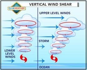
- Strong opposing winds:“Generally, the monsoon conditions are not favourable for cyclones to develop in the North Indian Ocean,” explained Roxy Mathew Koll, climate scientist at the Indian Institute of Tropical Meteorology and contributing author for the IPCC’s Sixth Assessment Report (AR6), published in August. “This is because of the strong opposing winds in this region — the lower atmospheric winds are in one direction (southwesterly) and the upper atmospheric winds are in the other direction (northeasterly). This prevents a cyclone from developing vertically.”
Then, what contributed to the formation of Cyclone Gulab?
The remnants of a cyclone (rotational element) formed in the South China Sea came to the Bay of Bengal. In the Bay of Bengal, the ocean-atmospheric conditions (mainly three factors — the in-sync phase of Madden Julian Oscillation (MJO), warm sea surface temperatures over the Bay of Bengal, and the formation of a low pressure system on September 24 along lower latitudes) were favourable for the cyclone to re-emerge again, as cyclone Gulab.
Re-emergence of cyclone Gulab into cyclone Shaheen:
Cyclone Gulab, after weakening into a depression, started gaining moisture from monsoon trough.As it reached Arabian Sea, the depression got intensified into deep depression and turned into a full-fledged cyclone called Shaheen- which wreaked havoc in Oman.
Where it can be used?
This can be used in topics related to Paper 1 (Tropical cyclones, Climate Change), Paper 2 (Tropical Cyclones, Floods) and GS1 (Important geophysical phenomena).
Tags: UPSC, Geography, Optional, Tropical Cyclones, Oceanography, Cyclone Gulab, Cyclone Shaheen, Climate Change.
Sources:
Deteriorating air quality in Delhi- the menace of winter smog
Why in News? -The first severe smog episode has hit Delhi and the National Capital Region (NCR) recently.
Reasons behind high pollution levels?
WHAT HAPPENS IN WINTER?
- According to a study conducted by the National Physical Laboratory 72 per cent of Delhi's wind in winters comes from the northwest, while the remaining 28 per cent comes from the Indo-Gangetic plains.
- Winter inversion(The dip in temperatures is also behind the increased pollution levels. As temperature dips, the inversion height — which is the layer beyond which pollutants cannot disperse into the upper layer of the atmosphere — is lowered. The concentration of pollutants in the air increases when this happens), valley effect in addition to industrial emissions, vehicular emissions are some of the reasons for the increasing amount of air pollution in winter.
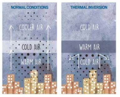
- Air pollution in Delhi is blamed on crop-burning—time when farmers set fire to leftover rice stalks and straw after harvest, a practice known as stubble or paddy burning.The burning coincides with meteorological conditions that lead to temperature inversions, which trap smoke in place.
- Industrial Pollution Delhi has the highest cluster of small-scale industries in India. According to CPCB, the national capital is home to and surrounded by highly pollutive industrial clusters.
For example: The Najafgarh drain basin in Delhi—which includes the Anand Parbat, Naraina, Okhla and Wazirpur industrial areas—is the second most polluted cluster in India: its air are in the “critical” category in toxic content.
- Vehicular Emissions: The transport sector is the main source of PM2.5 emissions in Delhi (28 percent of all PM2.5 emissions). Data on vehicular pollution in Delhi shows the following: trucks generate 9 percent of emissions; 7 percent from two-wheelers; 5 percent from three-wheelers; 3 percent each from cars and buses; and 1 percent from light commercial vehicles. In all, these vehicles are responsible for 41 percent of the total pollution load in Delhi
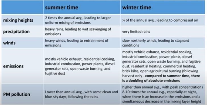
- Construction:The outskirts of NCT have roughly 360 brick kilns, mostly in the Jhajjar, Faridabad and Ghaziabad regions. Their emissions rise during the winter months. According to Delhi Pollution Control Committee (DPCC) officials, 30 percent of air pollution in the territory is caused by dust from construction sites.
Steps to Tackle the Problem of Pollution in Delhi:
- Initiatives such as a 1,600 km long and 5 km wide, The Great Green Wall of Aravalli green ecological corridor along Aravalli range from Gujarat to Delhi which will also connect to Shivalik hill range is being considered with planting of 1.35 billion (135 crores) new native trees over 10 years to combat the pollution.
- Technology - Subsidy to farmers for buying Turbo Happy Seeder (THS) which is a machine mounted on a tractor that cuts and uproots the stubble, in order to reduce stubble burning.
- The introduction of BS-VI vehicles, push for electric vehicles (EVs), Odd-Even as an emergency measure and construction of the Eastern and Western Peripheral Expressways to reduce vehicular pollution.
- Implementation of the Graded Response Action Plan (GRAP)
- Development of the National Air Quality Index (AQI)for public information under the aegis of the CPCB.
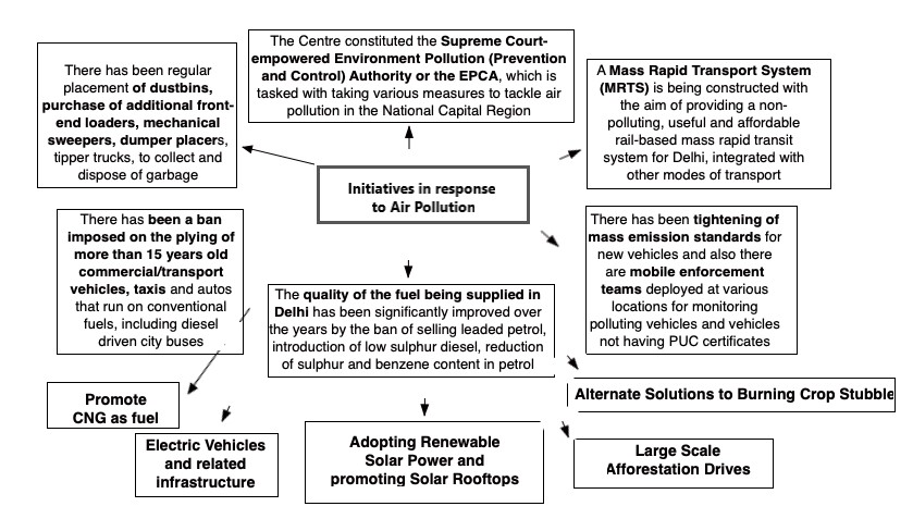
- Smog towers: around 24 m high structure uses a state-of-the-art filtration system to suck in polluted air, purify it using filters and push out clean, breathable air.
Smogis air pollution that reduces visibility. The word “smog” is a contraction of the words smoke and fog to refer to smoky fog due to its opacity, and odor.This kind of visible air pollution is composed of nitrogen oxides, sulphur oxides, ozone, smoke and other particulates. Man-made smog is derived from coal combustion emissions, vehicular emissions, industrial emissions, forest and agricultural fires and photochemical reactions of these emissions.
- Where can we use it
Paper1: climatology, Environmental geo (influence of man on ecology and environment, ecosystem degradation, sustainable development), Economic geo (LTG).
Paper2: Agriculture, Resources, contemporary issues (issues related to pollution).
GS: P3 (conservation, environmental pollution and degradation)
Reference:
- Air Pollution in Delhi: Filling the Policy Gaps
- Explained: Why does air pollution rise in October every year?
- Air pollution | How well do Delhi’s giant smog towers combat bad air?
- Amid criticism, Delhi govt invokes 5-point action plan against air pollution
- First Severe Smog Episode Hits Delhi, Could Be Longest In 4 Years: Report
- Delhi smog conditions improve; air quality in UP, Haryana still grim
Natural Capital
- Why in news: Natural Capital Accounting and Valuation of the Ecosystem Services (NCAVES) India Forum-2021was organized recently by MoSPI in India.
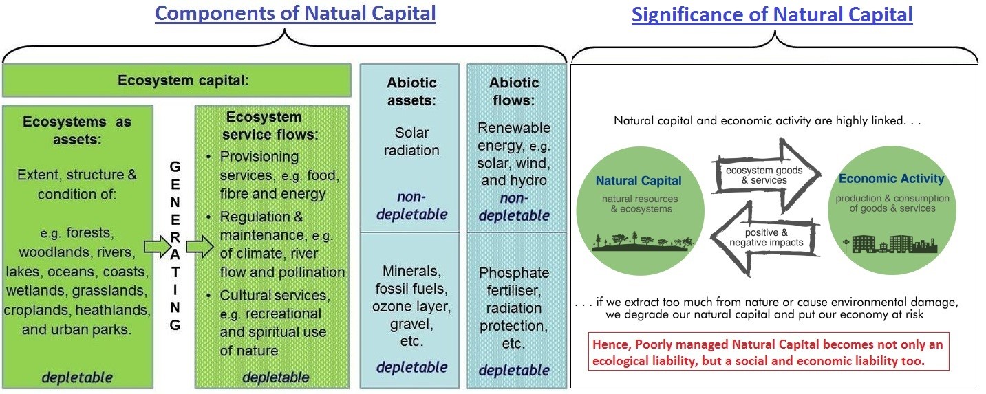
- The Convention on Biological Diversity (CBD) defines natural capital as the world’s stocks of natural assets which include geology, soil, air, water and all living things. It is from this Natural Capital that humans derive a wide range of services, often called ecosystem services, which make human life possible.
- Need for Natural capital accounting: Valuing natural capital enables governments to account for nature's role in the economy and human well-being. For businesses, it enables efficiency, sustainability, and managing risks in their supply chains.
- In June 2012 a 'natural capital declaration' (NCD)was launched at the Rio+20 summitheld in Brazil with an objective of integrating natural capital considerations into loans, equity, fixed income and insurance products, as well as in accounting, disclosure and reporting frameworks.
- In July 2016, the Natural Capital Coalition released the Natural Capital Protocolwhich provides a standardized framework for organizations to identify, measure and value their direct and indirect impacts and dependencies on natural capital.
- A World Bank publication, “The Changing Wealth of Nations”highlighted that the depletion of natural capital poses a significant challenge to achieving poverty reduction and sustainable development objectives.
Sources:
RKVY-RAFTAAR
Rashtriya Krishi Vikas Yojana – Remunerative Approaches for Agriculture and Allied Sectors Rejuvenation (RKVY-RAFTAAR) is aimed at strengthening infrastructure in Agriculture and Allied sectors to promote Agripreneurship and Agribusiness by facilitating financial aid and nurturing a system of business incubation.
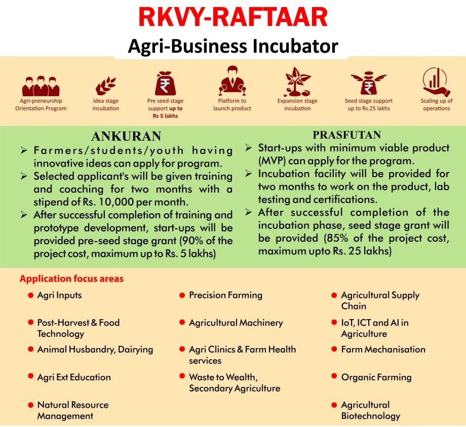
- The main objective of Rashtriya Krishi Vikas Yojana is to develop farming as the main source of economic activity. Some of the objectives also include:
- Risk mitigation, strengthening the efforts of the farmers along with promoting agri-business entrepreneurship through the creation of agri-infrastructure.
- Providing all the states with autonomy and flexibility in making plans as per their local needs.
- Helping farmers in increasing their income by encouraging productivity and promoting value chain addition linked production models.
- To reduce the risk of farmers by focusing on increasing the income generation through mushroom cultivation, integrated farming, floriculture, etc.
- Empowering the youth through various skill development, innovation, and agri-business models.
- The sub-schemesincludes national priorities such
- Bringing Green Revolution to Eastern India (BGREI),
- Crop Diversification Program (CDP),
- Reclamation of Problem Soil (RPS),
- Foot & Mouth Disease – Control Program (FMD-CP),
- Saffron Mission,
- Accelerated Fodder Development Programme (AFDP).
- Relevance of scheme:
- The scheme will incentivize states to enhance more allocation to Agriculture and Allied Sectors.
- It will strengthen farmer’s efforts through creation of agriculture infrastructure that will help in supply of quality inputs, market facilities etc.
- It will further promote agri-entrepreneurship and support business models that will maximize returns to farmers.
Tags: Raftaar, optional, GS, agriculture, UPSC
Tarn lakes
A tarn (or corrie loch)may be defined as a proglacialmountainlake, formed in a cirque/corries quarried by a glacier.The word tarn comes from the Old Norse tjorn which means "small mountain lake with no tributaries."
Formation:
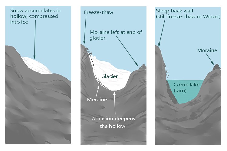
Tarns are the outcome of glaciers called cirques/ corries. Cirques form in depressions on mountainsides near the firn line. Eventually, the depression in which a cirque forms may become a large bowl shape in the side of the mountain, caused by weathering (by ice segregation, and erosion through plucking). The basin becomes deeper as it continues to be eroded.
Tarns may either be seasonal features like the supraglacial lakes, or permanent features which form in the hollows left by cirques.Figure 1 shows the formation of Tarn Lake.
Features:
- Both corries and tarns are typically located in higher topographies to match their glacial origins. Tarn lakes are formed in glacially carved corries.
- They are often obstructed by moraines.
- Tarns are usually full of tiny, glacially-ground sediment that pass the light and make the water color.
- Some famous examples of tarn are: Lake Tear of the Clouds,Adirondack Mountains, and New York.
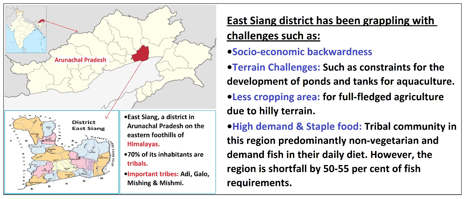
Rice-fish farming – a potential venture of livelihood security for the tribal community of East Siang district
What is Rice-Fish farming?
It is a polyculture practice that integrates rice agriculture with aquaculture, most commonly with freshwater fish. This practice is highly valued as it was one of the first to be considered as a “Globally Important Agricultural Heritage System” according to FAO-GEF (Global Environment Facility).
Potential benefits for the tribal communities of East Siang from Rice-Fish farming:
- It will ensure food and nutritional security in the region by providing predictable, convenient supply of food.
- Agricultural diversification: It provides livelihood opportunities along with additional source of income for the tribal communities there by leading to an improvement in the socio-economic conditions.
- High Productivity:Rice yields from the rice-fish system were 10-26 per cent higherand material inputs were seven per cent lower than the conventional monoculture rice farming.
- Several ecological benefits such as:
- Improved land use efficiency and water resource conservation.
- Reduced GHG emissions: Methane emissions from rice-fish cultivation system is 34.6 per cent less than that from a rice monoculture cultivation system.
- This method is beneficial to restore soil fertility and avoid soil degradation, which is a major global environmental issue in monoculture farming.
- Processing of fish produce will add other benefits such as more employment, value addition, startup creation and innovation which will further help in fostering diffusion of innovation.
Where it can be used?
This can be used in topics related to Paper 1(Food and nutritional problems, Food Security), Paper 2 (Agriculture, Aquaculture, Hill area development) and GS3 (Agriculture).
Tags: UPSC, Geography, Optional, Case Study, Rice-Fish Farming, North East Region, Agriculture, Farmers Income, Food security.
Sources:
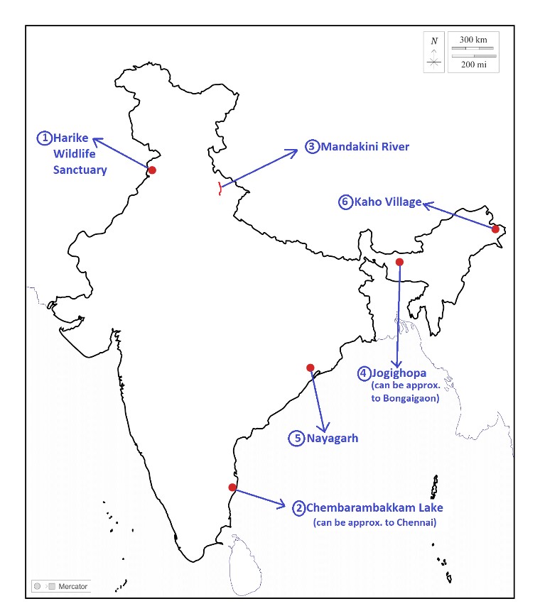
Harike Wildlife Sanctuary
|
Harike Wildlife Sanctuary · Why in news: Punjab planning for the conservation of Indus River dolphin which are found in this sanctuary and in the lower Beas River in India. · It is a man-made and the largest wetland in northern India in the border of Tarn Taran Sahib district and Ferozepur district of Punjab& also a designated Ramsar site. · It is located downstream of the confluence of the Beas and Sutlej rivers just south of Harike village. · Important fauna here includes Smooth-coated otters (IUCN, Vulnerable) and Gharials (IUCN, Critically endangered). · It’s an important site for winter migratory birds which arrive through the Central-Asian flyway. · Grappling with challenges such as encroachment, weed infestation, industrial effluents, illegal fishing and poaching of birds. |
|
Chembarambakkam Lake · Why in news: Excess water is being released from Chembarambakkam reservoir amid incessant rains. · It’s an artificial fresh water lake located in Chennai, Tamil Nadu & also known as PuliyurKottam. · The Adyar River originates from this lake. · Monsoon type of climate with dry summers (Koppen, As) found here. · Vegetation around the lake mainly includes Tropical dry evergreen forests. · Facing challenges from industrial growth and urban sprawl around the lake. |
|
Mandakini River · Why in news:Severely threatened byEncroachment, Concretization and Pollution · It is a tributary of the Alaknanda River in the Indian state of Uttarakhand. · It emerges from the Chorabari Glacier& flowsthroughRudraprayag district. · The river basin is seismically and ecologically fragile due to its position along a collision zone. · Tundra type of climate (Koppen, Et) found in this region. · Himalayan moist temperate forests found here with species like Pine, Cedar and Silver fir. |
|
Jogighopa · Why in news:India’s first international multi-modal logistic park to come up in Jogighopa. · It’s a small town located in the Bongaigaon district of Assam. · Situated on the northern bank of Brahmaputra River. · Alluvial and sandy loam soils found here. · Monsoon type of climate with dry winters (Koppen, Cwg) found here. · Tropical moist deciduous found here with species like teak, sal and bamboo. |
|
Nayagarh · Why in news: Several villages in the district received community & forest resource rights under FRA. · It’s a district nestled in Eastern Ghats of Odisha & it’s a part of the Red Corridor. · Mahanadi and Dahuka rivers flow through the district. · Savaraand Kondh tribes found in the district. · Climate: Tropical Savannah type (Koppen, Aw), Vegetation: Tropical moist deciduous. · Agriculture is the main occupation of people here. Important crops: Rice, Maize, ragi, pulses and oil seeds. |
|
Kaho Village · Why in news: DIPR conducts Azadi Ka Amrit Mahotsav at Kaho Village. · Located in India-China LACin Anjaw district of Arunachal Pradesh. · Situated on the banks of Lohit River. · Cold, humid type of climate with short summers (Koppen, Dfc) found here. · Alluvial, loamy and Sandy loam soils found here. · Meyor tribe (Buddhists by faith) found here. |
Share the article
Get Latest Updates on Offers, Event dates, and free Mentorship sessions.

Get in touch with our Expert Academic Counsellors 👋
FAQs
Geography Current Affairs focuses on the contemporary issues, events, and developments in the field of geography. It covers recent geographical phenomena, environmental changes, geopolitical shifts, and related news. This differs from regular geography studies which may focus more on foundational concepts, historical contexts, and theoretical frameworks.
Updates are provided regularly to ensure that subscribers stay informed about the latest developments in geography. Typically, updates are provided on a fortnightly basis, depending on the frequency of significant events and changes in the field.
Absolutely. Geography Current Affairs serves as a valuable resource not only for Geography optional but also for GS papers, especially GS Paper 1 (covering Indian Heritage and Culture, History, and Geography of the World and Society) and GS Paper 3 (covering Technology, Economic Development, Biodiversity, Environment, Security, and Disaster Management). It aids in building a holistic understanding of various topics and strengthens answer-writing skills by incorporating contemporary examples and perspectives.
Geography Current Affairs holds immense importance for UPSC preparation, particularly for aspirants opting for Geography optional. It helps candidates stay updated with the latest developments, geographical phenomena, environmental issues, and geopolitical shifts worldwide, aligning them with the dynamic nature of the subject as tested in the UPSC examinations.

