Wednesday, 30th March 2022
Assam-Meghalaya Pact
In News
Recently, the Assam and Meghalaya governments signed an agreement to resolve their 50-year-old border dispute in six of the 12 locations.
The dispute
- Meghalaya was carved out of Assam as a separate state in 1972 but the new state had challenged the Assam Reorganisation Act, 1971, leading to dispute in 12 locations in the border areas.
- Apart from Meghalaya, Assam has boundary disputes with Arunachal Pradesh, Mizoram and Nagaland.
- All these States, two as Union Territories initially, were carved out of Assam between 1963 and 1972.
- The two major points of contention are:
- Meghalaya's Langpih district, bordering the Kamrup district of Assam, in West Garo Hills: Langpih was part of the Kamrup district during the British colonial period but after India's Independence in 1947, it became part of the Garo Hills and Meghalaya.
- Mikir Hills: Meghalaya has questioned Blocks I and II of the Mikir Hills, now Karbi Anglong region, being part of Assam. Meghalaya says these were parts of erstwhile United Khasi and Jaintia Hills districts.
- Last year, in a sharp escalation of the boundary dispute between Assam and Mizoram, at least five Assam Police personnel were killed in violent clashes at the border areas.
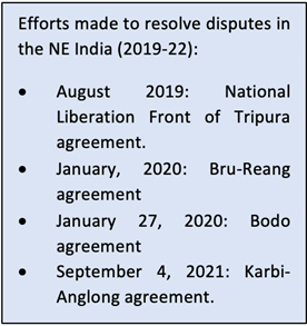
Resolution efforts made so far
- Several attempts had been made in the past to resolve the boundary dispute between Assam and Meghalaya.
- In 1985, an official committee to resolve the issue was constituted under the former Chief Justice of India Y V Chandrachud. However, a solution was not found.
- Last year, both state governments identified six of the 12 areas under dispute — Hahim, Gizang, Tarabari, Boklapara, Khanapara-Pilingkata, Ratacherra — for resolution in the first phase.
- The recent agreement was based on the final set of recommendations made jointly by both states in January this year.
- Officials said the next step will involve delineation and demarcation of the boundary by Survey of India in the presence of representatives of both governments.
- It will then be put up in Parliament for approval.
Details of the final resolution
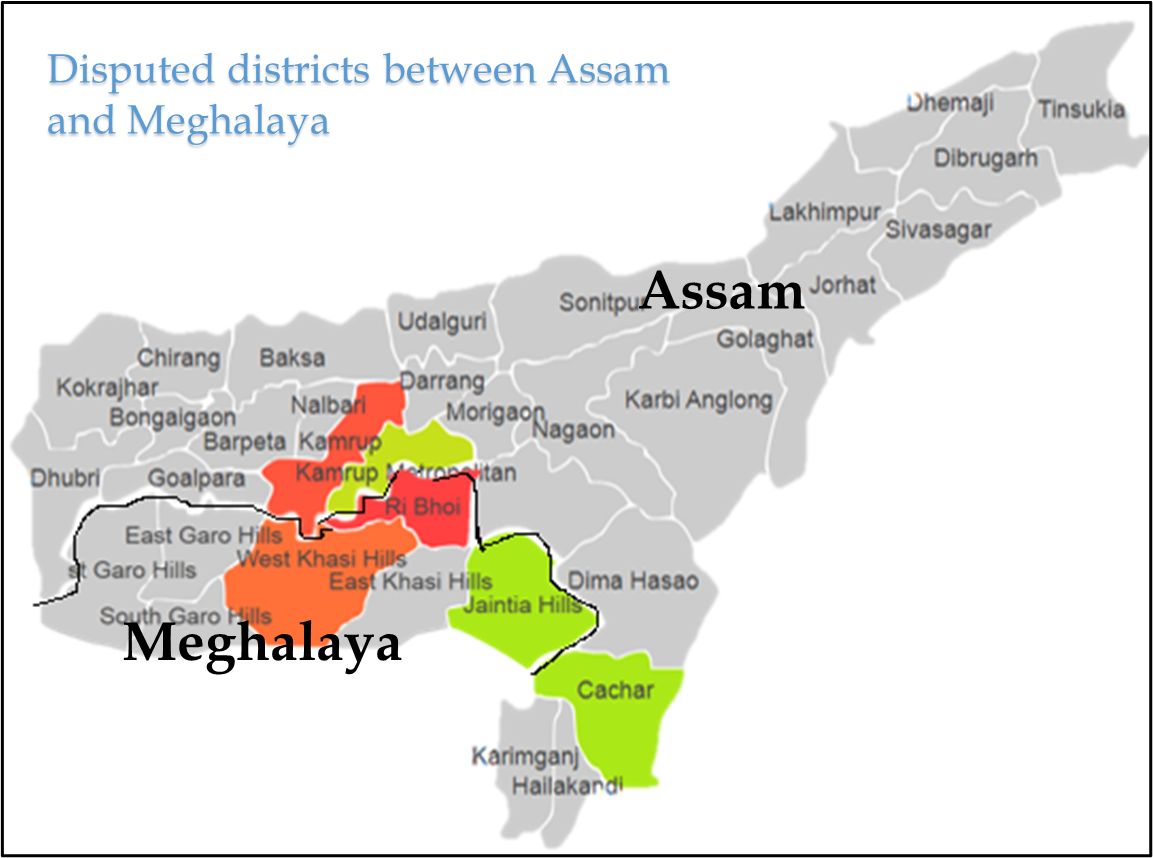
- The 12 disputed areas lie in the under the Kamrup and Cachar districts of Assam and the West Khasi Hills, Ri-Bhoi and East Jaintia Hills districts of Meghalaya.
- The two States had in June 2021 adopted a “give-and-take” policy to start the process of resolving the boundary dispute by constituting three regional committees each.
- The draft resolution, prepared on the basis of the recommendations of the regional panels, proposed dividing the disputed 36.79 sq. km land in the six areas of difference between the two States.
- While Assam will get 18.51 sq. km of the disputed areas, Meghalaya will get the remaining 18.28 sq.km.
- With the signing of the agreement 70% of the inter-State boundary has now become dispute-free.
Sources:
- 70% resolved: Amit Shah as Assam, Meghalaya sign pact over decades-old border row:
- Explained: Assam-Meghalaya border dispute and today's ‘historic' agreement:
- Assam, Meghalaya sign pact to resolve border dispute in 6 locations; Amit Shah terms it ‘historic’:
- Assam, Meghalaya sign agreement to resolve border dispute:
Dedicated epidemiologist cadre
In News
India plans to ready a bank of specialists to tackle outbreaks of infectious diseases in the future
About the News
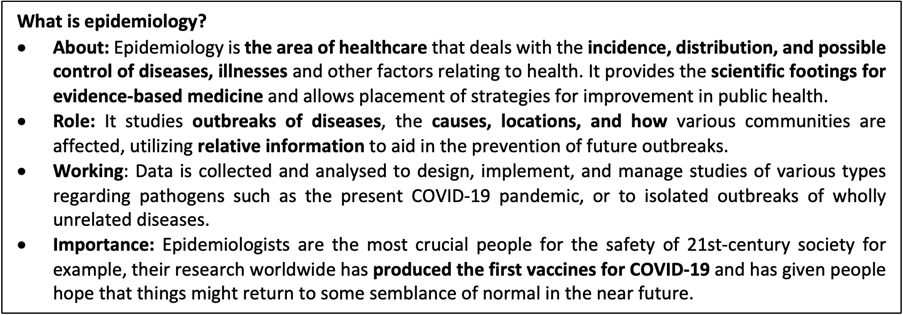
- Ministry of health (MoH) has recently proposed to set up a cadre of frontline epidemiologists to counter future pandemics.
- In this direction, National Centre for Disease Control (NCDC) of health ministry had previously begun training programmes for epidemiologists across the country which have already been completed in Rajasthan, Uttarakhand and Jammu & Kashmir.
- The next sessions are planned for Arunachal Pradesh and Andhra Pradesh.
- Zoonotic threats have in recent years assumed significance given the epidemics emanating from animal sources, including avian flu and covid-19.

What are the major highlights of the Plan?
- Training: The plan is to train epidemiologists across India so that there is a ready bank of specialists to tackle any outbreaks of infectious diseases in the future. The specialist cadre will also be trained to devise strategies for other public health challenges of the future.
- Epidemic Intelligence Service: India to leverage the already cadre of EIS who will be involved in the training programme and roll-out.
- Cadre composition: Each training session is expected to be attended by about 50-60 epidemiologists from at least 20 districts of a particular region. Training will also involve microbiologists, district surveillance officers and paramedical staff.
- New course: A 3/3 frontline epidemiology training course will be strategically planned and will happen every three months for three days wherein district level medical officers participate.
- Collaborations: Field Epidemiological training will be done in collaboration with veterinary institutes which will look for the zoonotic threats in future along with concepts and techniques of molecular epidemiology.
- Types of training: Three types of training will be provided to the epidemiologists. The first month will include basic epidemiology concepts, second month to train how to review the situation for surveillance and in the third month, epidemiologists will be given a task -- they have to identify any particular disease in their district and write a report on an outbreak investigation.
Sources:
National AIDS and STD Control Programme
In News
The Union Cabinet has approved the continuation of the National AIDS and STD control programme.
About the News
- The approval is for phase-V of the programme.
- The continuation of the programme will be from April 1 to March 31, 2026 (a period of five years) with an outlay of Rs 15471.94 crore.
National AIDS and STD control programme
- What is it? The National AIDS and STD control programme is a Central Sector Scheme fully funded by the Government of India.
- Function: It was launched in 1992 and is being implemented as a comprehensive programme for prevention and control of HIV/ AIDS in India.
- Phases: Since then, four phases of NACP have been successfully completed.
- The NACP I started in 1992, focused on slowing down the spread of HIV infections to reduce morbidity, mortality and impact of AIDS in the country.
- NACP II launched in 1999 aimed to reduce the spread of HIV infection in India, and to increase India’s capacity to respond to HIV/AIDS on a long-term basis.
- NACP III was launched in 2007 with the goal of Halting and Reversing the Epidemic over its five-year period.
- NACP IV, launched in 2012, aimed to accelerate the process of reversal and further strengthen the epidemic response in India through a cautious and well-defined integration process over the next five years.
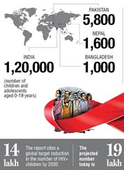
- Phase V of the Programme: The NACP Phase-V will take the programme towards the attainment of United Nations’ Sustainable Development Goals 3.3 of ending the HIV/AIDS epidemic as a public health threat by 2030.
- The programme will offer free HIV prevention, detection and treatment services in facility and community settings to high-risk, vulnerable and other ‘at-risk’ populations and PLHIV without any stigma and discrimination promoting equity and inclusiveness.
- The programme will include community system strengthening through formal and informal engagement with an emphasis on the decentralized model of district-level programme monitoring and community feedback loop.
- It will continue special attention to most at-risk populations, youth, and pregnant women offering a comprehensive package of services.
- The community will be engaged in the design, concurrent appraisal and feedback to the project for providing strategic guidance and mid-course corrections.
- Significance: The national AIDS response under NACP has been globally considered to be an extremely successful programme. This is because:
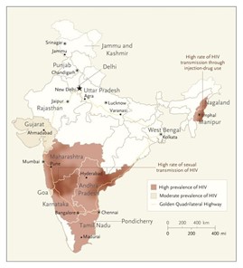
- The annual new HIV infections in India has declined by 48% against the global average of 31% (the baseline year of 2010).
- The annual AIDS-related deaths have declined by 82% against the global average of 42% (the baseline year of 2010). As a result, the HIV prevalence in India continues to be low with an adult HIV prevalence of 0.22%.
- Several initiatives like the HIV/AIDS Prevention and Control Act (2017), Test and Treat Policy, Universal Viral Load Testing, Mission Sampark, Community-Based Screening, transition to Dolutegravir-based Treatment Regimen etc. have augmented the success of NACP.
Source:
- Union Cabinet approves continuation of National AIDS and STD Control Programme
- Cabinet approves extension of National AIDS, STD control programme to March 31, 2026
Image source:
Guru Har Krishan
On March 30, 1664, Guru Har Krishan, the eighth Guru of Sikhism, breathed his last. Guru Har Krishan was the youngest of all the Sikh Gurus. His had a tenure of only 2 years, 5 months and 24 days, yet within this short period he served humanity to the best of his ability. An epidemic of smallpox swept through Delhi when the guru was visiting, and he selflessly tended to the patients irrespective of their religion, caste, or community. Har Krishan was born on July 23, 1656, in Kiratpur Sahib, Rupnagar, Punjab, India, to Guru Har Rai and Kishan dei (Mata Sulakhni). He had one elder brother Ram Rai. His father was the seventh guru of Sikhism and well-known for being a compassionate and wise soul. As he was dying, the boy muttered the words “Baba Bakale,” meaning that his successor should be sought in the village of Bakala. After a search was conducted, Tegh Bahadur, son of Hargobind, the sixth Guru, was located in Bakala and anointed the ninth Guru.

Sources:
India - Sri Lanka Relations
In News
Amid ongoing historic economic crisis in Sri Lanka, India and Sri Lanka inked six agreements to boost bilateral cooperation.
Details of the Agreement
- The MoUs include implementation of Sri Lanka Unique Digital Identity (SL-UDI) programme with India’s grant assistance and for providing Maritime Rescue Coordination Center.
- There is an MoU on implementation of Hybrid Power Projects in three Islands off Jaffna and also on cooperation in development of Fisheries Harbours in Sri Lanka.
- The two sides signed MoUs for the establishment of modern computer labs and smart boards with customised curriculum software in 200 schools in Galle District and a separate MOU between Sushma Swaraj Institute of Foreign Service and the Bandaranaike International Diplomatic Training Institute.
Background of India-Sri Lanka Relations
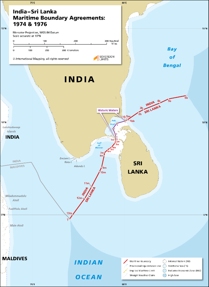
- Sri Lanka is India’s closest maritime neighbour and is just 30 nautical miles away from the territorial boundary. India and Sri Lanka have a legacy of intellectual, cultural, religious, and linguistic interaction and the relationship between two countries is more than 2500 years old.
- The nearly three-decade long armed conflict between Sri Lankan forces and the LTTE came to an end in May 2009. While India supported the right of the Government of Sri Lanka to act against terrorist forces, it also emphasized that the rights and welfare of civilian population should not get enmeshed in hostilities against the LTTE.
- Bilateral relations are shaped through key agreements like the Indo-Sri Lanka Free Trade Agreement (ISFTA), which has provided much impetus for bolstering economic ties. In addition, joint participation in international platforms such as the SAARC and the BIMSTEC have driven bilateral cooperation.
- In last 2-3 months, India is also helping Sri Lanka which is in the grips of one of its worst economic meltdowns in history. Sri Lanka is facing the fears of a sovereign default and an extremely low $1.6 billion foreign reserves.
- This reduced capacity to import essentials such as food, fuel, and medicines, made the start of the year 2022 on a rather challenging note, marked by further shortages and an economic upheaval.
Broad Contours of India- Sri Lanka Relations
- Political Relations: There are regular high-level exchanges of visits at Presidential and Prime Ministerial levels. Also, External Affairs Minister (EAM) visits are also frequent.
- Various mechanism such as SAARC, BIMSTEC, Colombo Process (CP), India-Sri Lanka Joint Commission, ‘India- Sri Lanka-Maldives’ trilateral mechanism exist for bilateral and multilateral political dialogues.
- Commercial Relations: In 2020, India was Sri Lanka’s 2nd largest trading partner with the bilateral merchandise trade amounting to about USD $ 3.6 billion. Sri Lankan exports to India have increased substantially since 2000 when India-Sri Lanka Free Trade Agreement (ISFTA) came into force and more than 60% of Sri Lanka’s total exports to India over the past few years have used the ISFTA benefits.
- FDI: In addition to being Sri Lanka’s largest trade partner, India is also one of the largest contributors to Foreign Direct Investment in Sri Lanka. FDI from India amounted to about US$ 1.7 billion during the period 2005 to 2019.
- Development Cooperation: With grants alone amounting to around USD 570 million, the overall commitment by India is to the tune of more than USD 3.5 billion. Demand driven and people-centric nature of India’s development partnership with Sri Lanka have been the cornerstone of this relationship.
- Various projects include completion of close to 50000 houses under the Indian Housing Project; country-wide 1990 Emergency Ambulance Service and supply of defence equipment; upgradation of railway line from Colombo to Matara; supply of engine kits for buses, diesel locomotives railways etc.
- A US$ 100 million LoC for undertaking solar projects in Sri Lanka has been signed between Sri Lanka and EXIM Bank in 2021.
- Cultural relations: The Cultural Cooperation Agreement signed by both the countries in 1977 forms the basis for periodic Cultural Exchange Programmes between the two countries.
- People-to-people ties: Buddhism is one of the strongest pillars connecting the two nations and civilizations from the ancient times. India during the Virtual Bilateral Summit 2020 announced a USD 15 million grant assistance for protection and promotion of Buddhist ties between India and Sri Lanka.
- To further strengthen people-to-people ties, the first ever pilgrimage to Bodh Gaya for Sri Lankan Armed Forces personnel and their families was organized in 2018.
- Cultural exchanges are being promoted through India-Sri Lanka Foundation and Swami Vivekananda Cultural Centre (SVCC). SVCC actively promotes awareness of Indian culture.
- Tourism: India formally launched the e-Tourist Visa (eTV) scheme for Sri Lankan tourists in 2015. In 2019, out of the total 1.91 million tourists, 355,000 tourists arrived from India.
- Human resource development: India now offers about 710 scholarship slots annually to Sri Lankan students. Indian institutes under ‘Study in India’ Program provide technical expertise across a diverse range of courses, and include programs in niche disciplines such as Ayurveda, Yoga, and Buddhist Studies.
- Defence and Security Cooperation: Both sides conduct joint Military exercise ('Mitra Shakti') and Naval exercise (SLINEX). India also provides defence equipment and training to Sri Lankan forces.
- Fishermen issue: Given the proximity of the territorial waters of both countries, especially in the Palk Straits and the Gulf of Mannar, incidents of straying of fishermen are common. India and Sri Lanka have agreed to set up a Joint Working Group (JWG) on Fisheries as the mechanism to help find a permanent solution to the fishermen issue.
- Indian Community: The People of Indian Origin (PIOs) in Sri Lanka comprise Sindhis, Borahs, Gujaratis, Memons, Parsis, Malayalis and Telugu speaking persons. Though their numbers (10,000 approximately) are lesser compared to Indian Origin Tamils (IOTs), they are economically prosperous and are well placed. According to 2011 census, population of IOTs is about 1.6 million.
India-Sri Lanka: Convergence and Conflicts
The two states have had fractious relations for three chief reasons.
- The foremost being the implementation of the long-pending Thirteenth Amendment that sought to introduce provincialism to provide political representation to the Tamil community.
- The second one pertains to Sri Lanka’s growing dependence on China and its sell-out of geostrategically important ports Colombo and Hambantota — both of which have caused distress in New Delhi.
- The final is the corollary of the second concern, which is the rejection of New Delhi as an important partner. Killing of Indian fishermen by the Sri Lankan Navy, as well as the cancellation of the East Container Terminal port contract to India are lingering issues that have added to these concerns.
Strategic Issue of China factor and Debt Trap leading to current economic crisis in Sri Lanka
- Over the period, China has converted its economic power into political concessions having strategic value. China has Hambantota port and Colombo Port City on 99-year lease. India and Japan are out of the East Container Terminal project. China is investing in infrastructure projects which have strategic value and therefore its hold over the country is far more than what the economic statistics reveal. Moreover, its policy of exploiting opportunities is really remarkable. It bailed out Sri Lanka from a severe forex problem at the end of 2021.
- In addition, the current Sri Lankan government are known to be closer to China than India and these developments have made India and her allies worried about China’s growing clout in the Indo-Pacific China, for instance, is set to commence the construction of a US $13 billion city on Sri Lanka’s seafront close to Colombo.
- China is also pushing Sri Lanka to immediately conclude the China-Sri Lanka free trade agreement (FTA), which the Chinese claim will benefit Colombo’s local market and products.
- Yet, this economic interaction with China has not been without ramifications for Colombo. Sri Lanka has been forced into a debt trap, and has had to sell its strategic assets though debt-equity swaps leading to creation of zones where its own sovereignty has been negated.
The latest developments in India- Sri Lanka Ties
Beginning January 2022, India has been providing crucial economic support to the island nation in the grip of a severe dollar crisis that, many fear, might lead to a sovereign default, and a severe shortage of essentials in the import-reliant country. India has lent over $2.5 billion in credit so far, in addition to $500 million for a shipment of diesel. It is also appointing experts to assist Sri Lanka’s economic recovery, and for various joint projects.
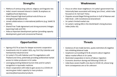
Conclusion: Cooperation across sectors does not diminish concerns on issues where the two neighbours might not align: Tamil minority rights and China’s importance in Sri Lanka’s economy. However, history, cultural closeness and the constraints of geography poise India and Sri Lanka as natural and permanent partners to tide over these issues and explore synergies in new avenues to further their respective economic and developmental aspirations jointly.
Question: Despite the convergence of objectives and interests, there is an urgent need for India and Sri Lanka to reinvigorate their bilateral relationship carefully and deliberately. Examine.
Sources:
- India, Sri Lanka ink six agreements to boost bilateral cooperation
- Brief on India - Sri Lanka Relations
- S Jaishankar meets Sri Lankan Finance Minister; discusses economic situation, India’s support
- Crisis-hit Sri Lanka seeks further $1 billion credit line from India
- Sri Lanka stares at economic ruin as India and China jostle for influence:
- Sri Lanka – India Relations: Opportunities for a New Connectivity Strategy:
- New oil deal, a glimmer of hope in India-Sri Lanka relations
- Charting a New Trajectory in India-Sri Lanka Relations
- Sri Lanka in ‘debt trap’, India’s response shows pushback against China has begun
- Friend in need: On India-Sri Lanka ties:
- To help Sri Lanka tackle economic crisis, India pledges to continue cooperation:
- INDIA – SRI LANKA RELATIONS:
- Sri Lanka and the return of geopolitics in the Indo-Pacific
- Essential Geopolitics: Complicated Relationship: India, Sri Lanka and China
- Deteriorating India-Sri Lanka Ties: The Way Out
- Sri Lanka, India and changing political dynamics:
- Indian power projects replace Chinese ventures in Sri Lanka:
- Troubled waters: On India-Sri Lanka fishing conflict:
- Renewing Indo-Lanka relations after a period of strain
Spacewalking astronauts
This is image of photo of spacewalking astronauts, which was taken by an Astrophotographer from Earth. Arrows show position of two astronauts, Raja Chari and Matthias Maurer. On March 23, NASA astronaut Raja Chari and European Space Agency (ESA) astronaut Matthias Maurer conducted a spacewalk outside the International Space Station (ISS). The spacewalk lasted for 7 hours during which the astronauts performed maintenance work at the ISS. It's probably the first ground-based picture showing two spacewalkers on the ISS at the same time. Any time an astronaut gets out of a vehicle while in space, it is called a spacewalk. A spacewalk is also called an EVA. EVA stands for extravehicular activity. The first person to go on a spacewalk was Alexei Leonov. He was from Russia. The first spacewalk was on March 18, 1965. It was 10 minutes long. The world record for the most spacewalks is held by Russian astronaut Anatoly Solovyev. He has been on 16 spacewalks.

Sources:
Hornbill Nest Adoption Program (HNAP)
- Context: Hornbill Nest Adoption Program (HNAP), is celebrating its tenth year of success in 2022.
- HNAP is a community-based hornbill conservation programme launched in 2012 by the Nature Conservation Foundation (NCF) in partnership with the Ghora-Aabhe Society (a council of village headmen in the Nyishi tribe) and the Arunachal Pradesh Forest Department.
- The Program takes inspiration from Pilai Poonswad’s initiative in Thailand that protects several species of hornbills in partnership with local villagers.
- HNAP is based on the idea that the local community protects the habitat and the nests, while other citizens and institutions adopt nests to support the running costs of the programme.
- Thus, the hornbill chicks have three sets of parents: the biological parents, the local Nyishi (tribes of Arunachal Pradesh) nest protectors, and adoptive hornbill parents who support the programme financially.
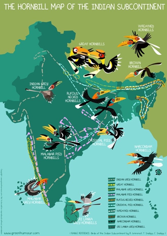
- The biggest achievement of the programme was that it has been able to fledge 173 hornbill chicks of three hornbill species namely great hornbill, wreathed hornbill and oriental pied hornbill — and protection of 35 hornbill nests in the reserve forest in 10 years.
- It has provided a source of livelihood to a number of people who were earlier hunters.
- Hornbills are indicators of the health of a forest, they are seed dispersers and rightly called the ‘farmers of the forest’; but they are globally threatened by habitat loss, fragmentation and hunting.
Source:
- The successful ‘Protect Hornbills’ project by the Nyishi tribe of Arunachal Pradesh turns 10
- Hornbill Nest Adoption Program (HNAP)
Image source:
Shrinkflation - Edukemy Current Affairs
- Context: Mondelez, parent company of UK chocolate-maker Cadbury has announced that its 200g Dairy Milk bar will shrink by 10 per cent.
- “Shrinkflation” is the phenomenon of products getting smaller while their price remains the same.
- It is a sign of an inflation economy i.e., as the price of ingredients rise, companies cut the size of their products (or the number of products in a multipack) and hope their customers won’t notice.
- It is basically a form of hidden inflation. Companies are aware that customers will likely spot product price increases and so opt to reduce the size of them instead, mindful that minimal shrinkage will probably go unnoticed by them.
- Through this, more money is squeezed out not by lifting prices but by charging the same amount for a package containing a little bit less.
- This is usually done to avoid demand destruction- the idea that beyond a certain price, consumer demand doesn’t just drop, it disappears.

Source:
- Shrinkflation: why a Dairy Milk gets smaller, not more expensive
- Dairy Milk is hit by shrinkflation amid dire BofE warning that Brits will suffer a 'historic' shock to their incomes:
Image source:
Articulated All-Terrain Vehicles
- Context: The Indian Army has recently issued a Request For Information (RFI) for the supply of Articulated All-Terrain Vehicles to be deployed in Ladakh and Kutch.
- Articulated All-Terrain Vehicle is a twin cabin, tracked, amphibious carrier for off road mobility.
- It is specially designed so that this equipment exerts low ground pressure on the soil and a pull-push mode of locomotion between two cabins facilitates mobility over varied terrains like snow, desert and slush.
- There is a ballistic protection in the cabin body that ensures protection to troops travelling in it from small arms fire.
- These vehicles are very useful to move troops or supplies in snow-bound terrains and in marshy/sandy environments. They can reach where wheeled vehicles cannot and can be very effective for patrolling and rapid deployment in operational situations.
- There are several Western manufacturers of Articulated All-Terrain Vehicles including Canada and Finland. The NASU vehicle of Finland is used by the Finnish, French, Belgian and the US Armies.

Source:
Image source:
Corner-Shot Weapon System
- Context:The corner-shot weapon system (CSWS) is at an advanced stage of being inducted by the Central Reserve Police Force (CRPF) and the Jammu and Kashmir police.
- The CSWS is aspecial purpose weapon designed by the Armament Research and Development Establishment (ARDE), Pune.
- It canengage targets located around the corners as the system bends and captures video feed thus saving soldiers from any surprise counter attack and is best suited for urban, close quarter situations.
- It is equipped withweapon, camera, laser, infrared illuminator and torch in front portion, while display, electronics, battery and swivelling mechanism are located at rear portion.
- Thebody is made from high–grade aluminium alloy to make it lighter and durable.
- Features like day night firing capability, colour display, digital zoom, zeroing facility, hot keys etc, makes it a very potent system for security forces engaged in Counter Insurgency and Counter Terror (CI/CT) operations.
- Thisindigenously designed and developed system has many superior features compared to its contemporary international systems.

Source:
Image source:
Unreformable criminal justice:TH
Essence: As per the authors, problems of the Indian criminal justice system are ingrained in not only the constitutive fabric of institutions, but also in the psyche of their functionaries. First, there is the problem of pendency of cases with over 4.4 crore cases pending in the courts. Second, justice mechanisms are inaccessible to marginalised classes of citizens due to focus on institution building rather than on capacity building. Third, there is the problem of abuse of power by the police.
Fourth, goal of our criminal justice system to achieve 100% crime prevention is not achievable as empirical evidence has shown that higher punishment has little impact on lowering crime rates. Fifth, non-custodial measures of punishment of offenders are yet to be implemented which is leading to overcrowding of prisons. Sixth, there is a shortage of reliable data collection, maintenance and analysis mechanisms as the National Crime Records Bureau’s methodologies are criticised on multiple grounds.
According to the authors experience, these problems will not go away with time and efforts. Thus, reforms in criminal laws and criminal justice would face difficulties in implementation. Accepting these problems before introducing the reforms will help in bringing the right set of reforms. For example, if we accept that pending cases cannot be disposed off, we will rein in our tendency to over-criminalise conduct.
Why should you read this article?
- To understand the problems of the Indian Criminal Justice System.
- To know about the recommendations of the authors to overcome these problems.
Source:
The folly of an ‘atmanirbhar’ internet: IE
Essence: As per the author, there are parallels between the Russian and Indian attempts to regulate Big Tech and to achieve the objective of internet sovereignty. Both countries mandate major platforms to have several officials be physically located within the country to address the government’s complaints and platforms are criminally liable for content on the platform for failure to comply with the rules.
As per the author, such a regulation is against the following principles. First, democracies must curb the media that spreads disinformation. Second, the internet, by definition, is a globally connected digital common, thus “Atmanirbhar Internet” is contradictory.
Why should you read this article?
- To understand the parallels between Russian and Indian attempts to regulate big tech.
- To know about the authors arguments against such regulations.
Source:
Realizing the potential of BIMSTEC: DH
Essence: The article speaks about the opportunities and challenges offered by BIMSTEC, whose 5th edition of summit level talks are being held in Sri Lanka. There are seven sectors of cooperation through this platform for south and south-east Asian economies (Bangladesh, Bhutan, India, Nepal, Sri Lanka, Myanmar and Thailand)- science, technology and innovation; trade and investment; environment and climate change; agriculture and food security; security; people to people contacts and connectivity.
Currently, the intra-regional trade amongst BIMSTEC members in 7% of all the global trade carried out by its members. This is in contrast to ASEAN’s 23% inter-member trade out of total trade. The member countries in BIMSTEC have trade pacts with other neighbors but not amongst themselves.
Security cooperation between the members has been pledged under Counterterrorism and Transnational Crime (CTTC) against terrorism, organized crime, drug trafficking human trafficking, illegal migration and radicalization. A legal ratification by members is due.
Many of the member nations have complementary economies, untapped human and natural resources, and huge potential. It is time to increase the partnership from bureaucratic levels to business/people to people ties and increase trade and business.
Why should you read this article?
- To understand the multisectoral levels of participation between the member countries of BIMSTEC.
- To know the areas of importance and laggards in the partnership.
Source:
The Jugaad Electrician
Background
Uninterrupted electricity supply was a distant dream for the villagers of Byang village of Jharkhand. Lack of regular electricity supply affected the daily life of the people residing in the area.

How did an electrician change the situation?
- Kedar Prasad Mahto, a 33-year electrician in the State Electricity Board Department constructed a hydropower plant on his own to solve the issue of the electricity supply in the village.
- He spent 18 years learning, saving money and procuring items for making the plant.
- The entire setup of the plant is done with trial-and-error method of what he learned over the years.
- He used discarded materials that he procured from scarp vendors and took up odd jobs to save money for the plant.
- His effort saw the daylight and the plant was successfully setup on the Senegarha river that passes through the village.
- Now, all street light and temple lights are lit with the electricity supply from Mahto’s plant in the village.
Quote: “Perform anonymous service. Whenever we do good for others anonymously, our sense of intrinsic worth and self-respect increases. ... Selfless service has always been one of the most powerful methods of influence.”-Stephen Covey
Source:
Share the article
Get Latest Updates on Offers, Event dates, and free Mentorship sessions.

Get in touch with our Expert Academic Counsellors 👋
FAQs
UPSC Daily Current Affairs focuses on learning current events on a daily basis. An aspirant needs to study regular and updated information about current events, news, and relevant topics that are important for UPSC aspirants. It covers national and international affairs, government policies, socio-economic issues, science and technology advancements, and more.
UPSC Daily Current Affairs provides aspirants with a concise and comprehensive overview of the latest happenings and developments across various fields. It helps aspirants stay updated with current affairs and provides them with valuable insights and analysis, which are essential for answering questions in the UPSC examinations. It enhances their knowledge, analytical skills, and ability to connect current affairs with the UPSC syllabus.
UPSC Daily Current Affairs covers a wide range of topics, including politics, economics, science and technology, environment, social issues, governance, international relations, and more. It offers news summaries, in-depth analyses, editorials, opinion pieces, and relevant study materials. It also provides practice questions and quizzes to help aspirants test their understanding of current affairs.
Edukemy's UPSC Daily Current Affairs can be accessed through:
- UPSC Daily Current Affairs can be accessed through Current Affairs tab at the top of the Main Page of Edukemy.
- Edukemy Mobile app: The Daily Current Affairs can also be access through Edukemy Mobile App.
- Social media: Follow Edukemy’s official social media accounts or pages that provide UPSC Daily Current Affairs updates, including Facebook, Twitter, or Telegram channels.

