
10 Aug to 24 Aug, 2026
GLACIAL RETREAT IN ZANSKAR BASIN
Why in news: A study published in The Cryosphere, examining 12 glaciers in the Zanskar Basin from 1992–2023, found that they are slowing and thinning due to climate change, with significant long-term implications for water availability in Zanskar and the wider Upper Indus basin.
About:
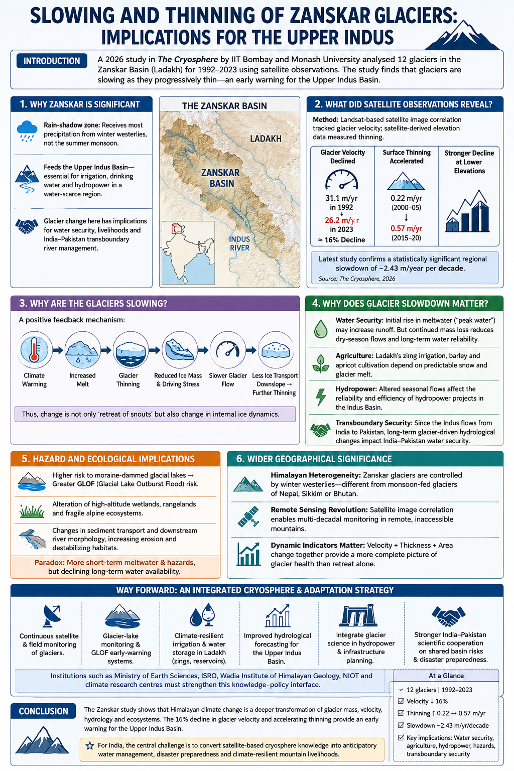
The Zanskar Basin of Ladakh, part of the cold-arid Western Himalaya, provides an important window into climate-induced glacier change. A 2026 The Cryosphere study by researchers from IIT Bombay and Monash University analysed 12 glaciers using satellite observations for 1992–2023, revealing that glacier flow is slowing as ice progressively thins.
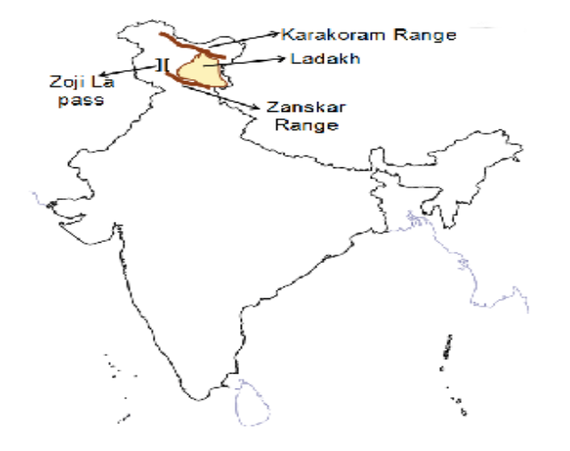
1. Why Zanskar is significant
- Zanskar lies in the rain-shadow zone, receiving most of its glacier-nourishing precipitation from winter westerlies, unlike monsoon-dominated central and eastern Himalaya.
- Its glaciers feed the Upper Indus Basin, crucial for irrigation, drinking water and hydropower in a water-scarce region.
- Hence, glacier change here has implications beyond cryospheric science—extending to water security, livelihoods and transboundary river management.
2. What did satellite observations reveal?
The study used Landsat-based satellite image correlation to track glacier movement and satellite-derived elevation data to measure thinning. This demonstrates how remote sensing can overcome the difficulty of sustained field monitoring in inaccessible high mountains.
Key findings:
- Average glacier velocity declined from 31.1 m/year in 1992 to 26.2 m/year in 2023—about 16% decline.
- Surface thinning accelerated from about 0.22 m/year (2000–05) to 0.57 m/year (2015–20).
- The decline was stronger at lower elevations, where warming and melt are greater.
The latest peer-reviewed study confirms a statistically significant regional slowdown of about 2.43 m/year per decade.
3. Why are the glaciers slowing?
The study highlights a positive feedback mechanism:
Climate warming → increased melt → glacier thinning → reduced ice mass/driving stress → slower glacier flow → less ice transported downslope → further thinning
Thus, glacier change is not simply a matter of retreating snouts; changes in internal ice dynamics can provide an important indicator of glacier health.
4. Why does glacier slowdown matter?
Water security: Initially, accelerated melting may increase runoff—often described as the “peak water” phase. But continued mass loss eventually reduces the glacier's capacity to provide reliable dry-season water.
Agriculture: Ladakh's traditional zing irrigation systems, barley and apricot cultivation depend heavily on predictable snow- and glacier-melt flows.
Hydropower: Changing seasonal flows can affect the reliability of hydropower systems in the Indus basin.
Transboundary security: Since the Indus flows from India into Pakistan, long-term glacier-driven hydrological changes have implications for India–Pakistan water security.
5. Hazard and ecological implications
Glacier thinning and retreat may:
- increase the vulnerability of moraine-dammed glacial lakes, raising GLOF risk;
- alter high-altitude wetlands and pasture ecosystems;
- modify sediment transport and downstream river morphology.
Thus, climate change can create a paradox: greater short-term meltwater and hazards, followed by declining long-term water availability.
6. Wider geographical significance
The study provides three important lessons:
First—Himalayan heterogeneity: Zanskar cannot be treated like monsoon-fed glaciers of Nepal, Sikkim or Bhutan because its mass balance is strongly influenced by winter westerlies.
Second—remote sensing revolution: Satellite image correlation enables multi-decadal glacier monitoring where continuous field observations are extremely difficult.
Third—dynamic indicators matter: Glacier velocity + thickness + area change together provide a more complete picture than retreat alone.
Way Forward
India needs an integrated Himalayan cryosphere-monitoring and adaptation strategy based on:
- continuous satellite and field monitoring;
- glacier-lake and GLOF early-warning systems;
- climate-resilient irrigation and water storage in Ladakh;
- improved hydrological forecasting for the Indus;
- integration of glacier science into hydropower and infrastructure planning;
- stronger India–Pakistan scientific cooperation on shared basin risks.
Institutions such as the Ministry of Earth Sciences and specialised climate research centres have an important role in strengthening this knowledge base.
Conclusion
The Zanskar study shows that Himalayan climate change is not merely “glaciers are retreating”; it is a deeper transformation of glacier mass, velocity, hydrology and ecosystems. The 16% decline in glacier velocity and accelerating thinning provide an early warning for the Upper Indus Basin.
Source : https://india.mongabay.com/2026/08/ladakh-glaciers-losing-speed-as-ice-melts-new-study-warns/
GLOBAL CRITICAL MINERALS OUTLOOK 2026
Why in news : Critical minerals have emerged as a key strategic issue amid intensifying global competition over mineral supply chains. The International Energy Agency's (IEA) Global Critical Minerals Outlook 2026 highlights persistent concentration in mineral refining and renewed supply disruptions, underscoring rising supply chain vulnerabilities.
About:
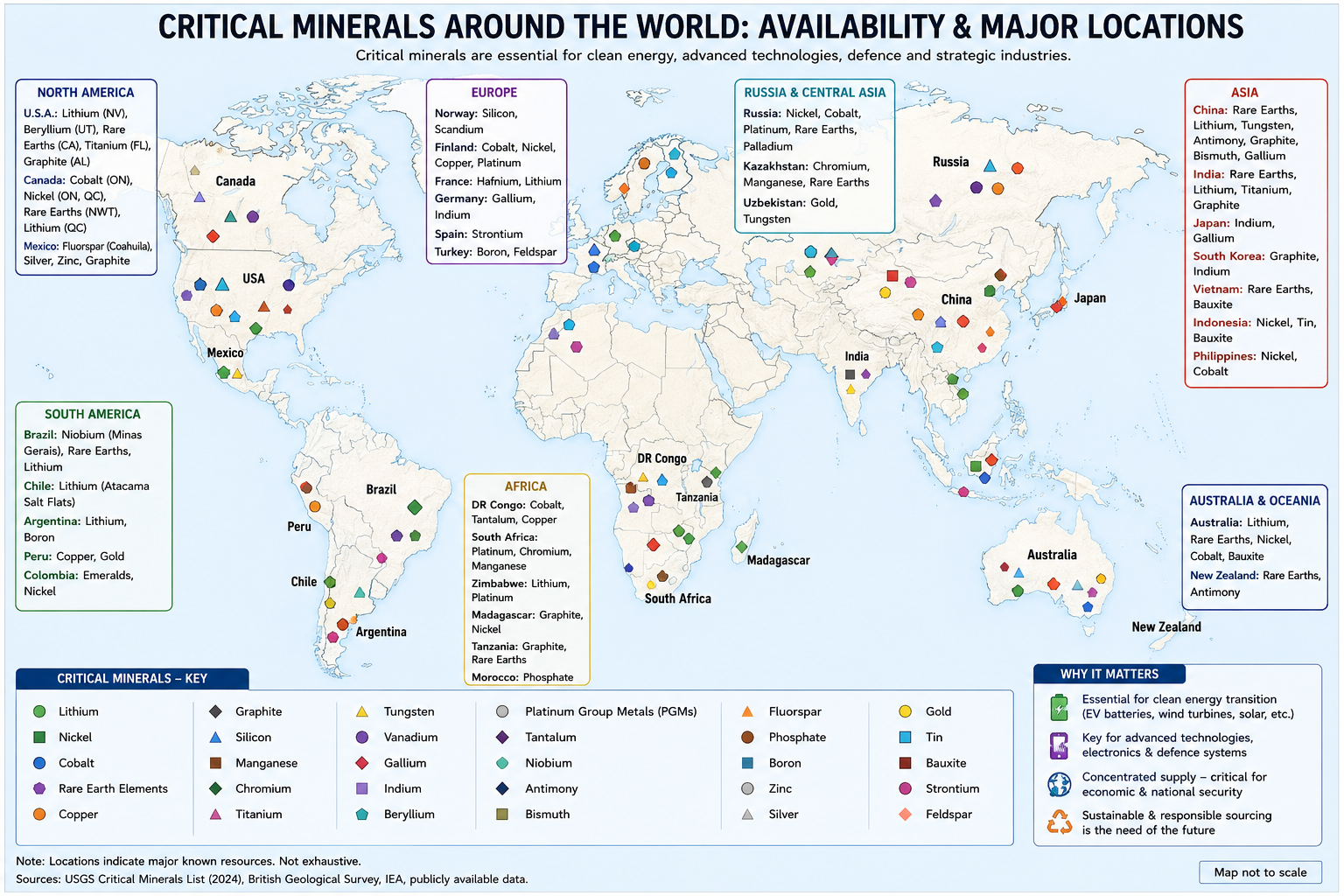
The global energy transition is creating a new geography of resources. Lithium, cobalt, nickel, graphite, copper and rare earth elements are essential for EV batteries, renewable-energy systems, power grids, semiconductors and advanced defence technologies. Hence, the strategic question is no longer simply “Who has mineral reserves?”, but “Who controls mining, refining, technology and supply chains?”
1. Why are critical minerals becoming critical?
A mineral becomes “critical” when it combines:
High economic/strategic importance + high supply risk
Thus, criticality is about vulnerability, not simply geological scarcity. A mineral may be relatively abundant globally but still become critical if its mining, refining or technology is concentrated in a few countries.
|
Mineral |
Major application |
Important geographical example |
|
Lithium |
EV batteries, storage |
Lithium Triangle, Australia |
|
Cobalt |
Batteries, superalloys |
DRC |
|
Nickel |
Batteries, stainless steel |
Indonesia |
|
Graphite |
Battery anodes |
China, Africa |
|
Rare earths |
Magnets, electronics, defence |
China |
|
Copper |
Grids, EVs, renewables |
Chile, Peru, DRC-Zambia |
2. The central problem: demand is rising faster than diversification
The IEA projects that demand for critical minerals will almost double by 2040, while lithium demand could more than triple. Nickel, graphite and rare-earth demand could rise by roughly 50–90%.
This is driven by:
EVs → batteries → lithium/cobalt/nickel/graphite
Wind turbines → rare-earth magnets
Solar + grids → copper
AI + semiconductors → gallium/germanium/rare earths
Thus, the energy transition is simultaneously creating a mineral transition.
3. Mining may be geographically dispersed—but refining remains concentrated
This is perhaps the most important geographical insight.
Mining ≠ Refining ≠ Manufacturing
A mineral may be extracted in one country, refined in another and converted into a final product elsewhere.
The IEA reports that the average share of the largest refining country for key energy minerals reached about 72% in 2025, up from 70% in 2023. China dominates refining of most major energy minerals, while Indonesia dominates nickel refining.
For example:
DRC → cobalt mining
↓
China → refining/processing
↓
Battery manufacturing → global EV industry
This creates a geography of value addition, where the country possessing the ore does not necessarily capture the greatest economic value.
4. Resource geography and core–periphery relations
Critical minerals demonstrate the classical geographical principle of uneven resource distribution.
- Cobalt: concentrated in the DRC.
- Lithium: important reserves in the South American Lithium Triangle and Australia.
- Nickel: Indonesia is a dominant producer.
- Rare earths: China has a dominant position in mining and especially processing.
This creates a core–periphery relationship:
Resource-rich regions → export raw materials
Technology-rich economies → refine, manufacture and capture greater value
This explains why mineral wealth does not automatically translate into broad-based development—a central issue in dependency theory and the resource-curse debate.
5. Critical minerals as a geopolitical weapon
Minerals are increasingly becoming instruments of resource nationalism.
China's export controls on several critical minerals intensified supply-chain concerns. In April 2025, China imposed controls on seven heavy rare-earth elements, causing difficulties for manufacturers outside China; some automakers had to reduce production or temporarily shut production lines.
The IEA estimates that full implementation of such rare-earth restrictions could put up to $6.5 trillion of downstream economic activity outside China at risk annually.
Similarly, the DRC, which supplies roughly two-thirds of mined cobalt, introduced export restrictions in 2025, demonstrating how producer countries can use resource control to influence global markets.
6. Chokepoints create cascading risks
The geography of critical minerals is also connected to transport geography.
The Strait of Hormuz illustrates this well. The 2026 Outlook highlights how disruption in the Middle East affected aluminium, sulphur and helium supply chains. Sulphur is particularly important because sulphuric acid is required for processing several critical minerals and also for fertiliser production.
Thus:
Geopolitical conflict → chokepoint disruption → raw-material shortage → mineral processing disruption → fertiliser/industrial shock
This is an example of cascading systemic risk in a globally interconnected economy.
7. The environmental paradox of the “green” transition
Critical minerals are essential for decarbonisation, but their extraction is not environmentally cost-free.
Lithium
Lithium brine extraction in the arid Andean region can intensify competition over scarce water resources.
Nickel
Large-scale nickel mining, particularly in Indonesia, can cause land-use change and ecosystem disruption.
Rare earths
Processing can generate substantial waste and, in some cases, radioactive by-products.
Therefore:
Fossil-fuel dependence ↓
but potentially
Mining pressure + water stress + ecological disruption ↑
This creates an important environmental-geographical question:
8. Africa: opportunity and the risk of remaining a raw-material frontier
Africa illustrates the contradiction particularly well.
The DRC and Zambia are major contributors to future copper supply, while Madagascar, Mozambique and Tanzania could significantly increase their share of global natural graphite production. African lithium production also increased sharply in 2025.
Yet Africa's refining capacity remains limited.
This raises a development question:
Will Africa repeat the old colonial pattern of exporting raw materials—or move towards refining and manufacturing?
Zimbabwe's commissioning of a lithium-refining facility in 2026 is a small but significant example of attempts to move up the value chain.
9. India and critical minerals
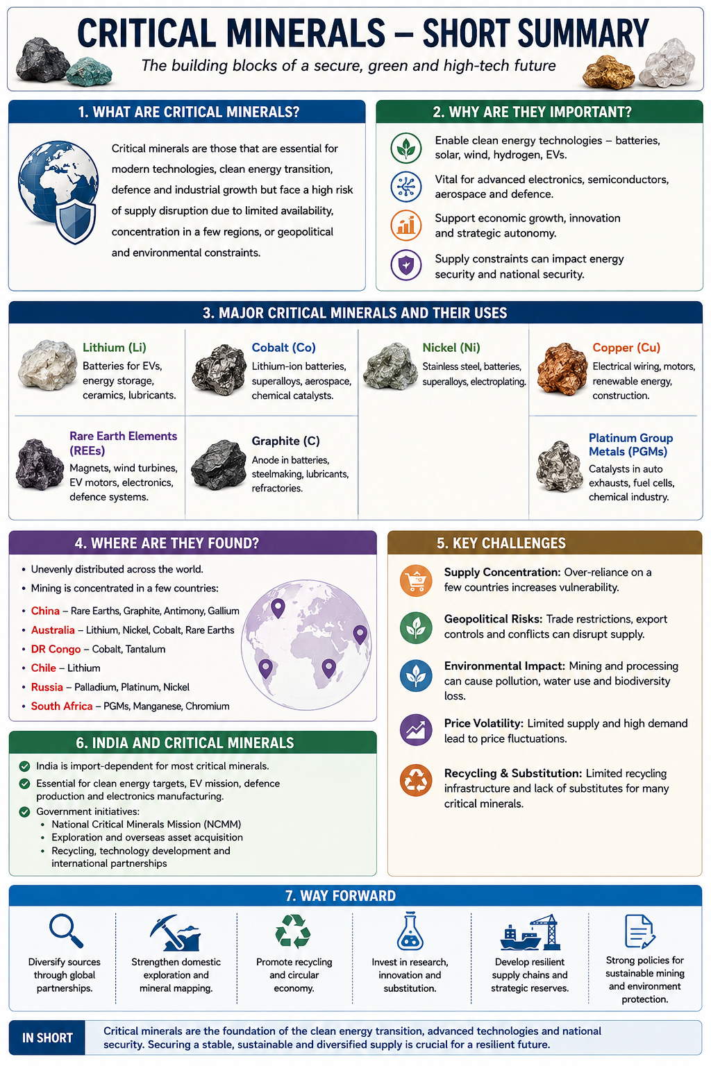
For India, critical minerals are directly linked to:
- EV manufacturing,
- renewable energy,
- electronics,
- defence,
- semiconductors,
- strategic autonomy.
India remains highly dependent on imports for several minerals and processed products, particularly lithium, cobalt, nickel and rare-earth-based inputs.
India's response
The National Critical Mineral Mission (NCMM) aims to strengthen the entire value chain.
Its targets include:
- 1,200 critical-mineral exploration projects
- auction of 100 critical-mineral blocks
- development of domestic production of at least 15 critical and strategic minerals
- acquisition of at least 50 overseas mineral assets by 2031.
This reflects a shift from merely securing mineral supplies towards securing the entire mineral value chain.
10. The way forward: from resource security to supply-chain resilience
The IEA points towards a three-layer strategy:
Short term: Strategic stockpiles → absorb temporary disruptions.
Medium term: Diversified mining + refining capacity → reduce dependence on dominant suppliers.
Long term : Recycling + substitution + circular economy → reduce pressure on primary extraction.
The IEA projects average recycling rates for key energy minerals could rise from around 10% today to nearly 20% by 2040 under current policies.
The goal should therefore be:
Linear economy
Mine → Process → Manufacture → Consume → Discard
↓
Circular mineral economy
Mine → Process → Manufacture → Use → Recover → Recycle → Reuse
Conclusion
The geography of critical minerals reveals a fundamental transformation in global power. Mineral reserves alone no longer determine strategic influence; control over refining, technology, finance, infrastructure and supply chains is equally important.
The IEA's 2026 assessment shows that while the clean-energy transition is reducing dependence on fossil fuels, it is creating new dependencies around minerals and processing capacity.
For India and other emerging economies, the strategic objective should therefore be:
“From resource security to value-chain security—from importing minerals to building capabilities in exploration, processing, manufacturing and recycling.”
This makes critical minerals not merely a resource-geography issue, but a central question of economic development, environmental sustainability and 21st-century geopolitics.
Source : https://www.iea.org/reports/global-critical-minerals-outlook-2026
HEATWAVES AND LIGHTNING
Why in news: Government has included heatwaves and lightning in the list of notified natural calamities under the operational guidelines of the State Disaster Response Fund (SDRF) and National Disaster Response Fund (NDRF) for the 2026–31 award period, enabling states to provide relief and assistance to affected people.
About:
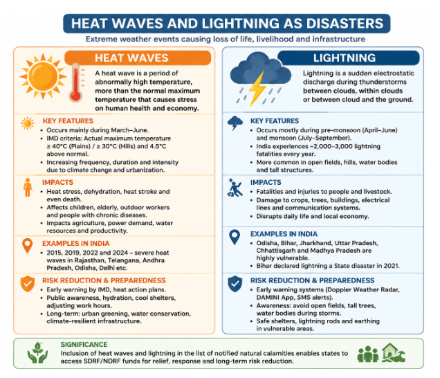
India's disaster profile is changing. Alongside floods, cyclones and earthquakes, extreme heat and lightning are emerging as major weather-related hazards with serious consequences for public health, livelihoods and infrastructure.
Recognising this changing risk landscape, the Government has included heatwaves and lightning in the list of notified natural calamities under the SDRF and NDRF operational guidelines for the 2026–31 award period. This enables states to use disaster-response resources for relief and assistance to affected populations. The decision follows recommendations of the 16th Finance Commission.
The significance is therefore larger than a funding change: it represents a shift from treating extreme heat and lightning mainly as weather events to recognising them as disaster-management challenges.
1. Why is this policy shift significant?
Under India's disaster-financing framework:
- SDRF is the primary fund available to states for immediate relief.
- NDRF supplements the SDRF when a disaster of severe nature requires additional assistance.
For 2026–31, the 16th Finance Commission has recommended ₹1,63,521 crore for SDRF and ₹79,406 crore for the national disaster fund, with dedicated mitigation allocations also provided.
Including heatwaves and lightning therefore creates a clearer fiscal mechanism for disaster response.
The conceptual shift
Earlier:
Heatwave/lightning → weather hazard → fragmented departmental response
Now:
Heatwave/lightning → notified disaster → institutionalised relief + response + mitigation
2. Why are heatwaves becoming a major disaster risk?
A heatwave is not merely a period of high temperature. Its disaster potential depends on:
Intensity + duration + exposure + vulnerability
The same temperature can produce very different impacts in:
- an air-conditioned urban neighbourhood,
- an informal settlement,
- an agricultural field,
- a construction site.
Recent evidence
Between 1 March and 26 July 2026, India recorded 4,853 heatstroke cases and 20 confirmed deaths. Maharashtra recorded the highest number of deaths (11), while Telangana recorded the highest number of cases (915).
3. Heatwaves have multidimensional impacts
A. Public health
Extreme heat can cause:
- heat exhaustion,
- heatstroke,
- dehydration,
- cardiovascular stress,
- kidney-related complications,
- increased mortality among vulnerable groups.
Particularly vulnerable are:
elderly + children + outdoor workers + homeless people + people with limited access to cooling
The government has already been implementing heat-health interventions through the National Programme on Climate Change and Human Health (NPCCHH) and the National Action Plan on Heat-Related Illness.
B. Agriculture
Heatwaves can cause:
high temperature → moisture stress → crop damage → lower yields
For example, terminal heat stress in wheat can shorten the grain-filling period and reduce productivity in north-western India.
Thus, extreme heat can become both a livelihood disaster and a food-security risk.
C. Labour productivity
Outdoor workers in:
- construction,
- agriculture,
- mining,
- transport,
- street vending
face greater heat exposure.
Extreme heat therefore creates a link between:
climate change → occupational health → productivity → household income
This makes heatwave management an important component of labour and social policy, not merely meteorological management.
D. Urban heat
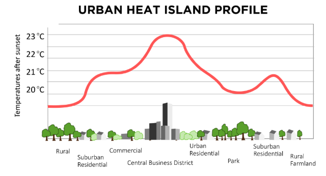
Cities can experience higher temperatures because of the Urban Heat Island (UHI) effect.
Concrete surfaces, limited vegetation, dense construction and waste heat can increase thermal stress.
Example: Rapidly growing cities such as Delhi, Ahmedabad and Hyderabad require heat-action planning alongside urban planning.
Hence, heatwave resilience should include:
- cool roofs,
- urban trees,
- shaded public spaces,
- water access,
- heat shelters,
- climate-sensitive building design.
4. Lightning: an underestimated disaster
Lightning is often treated as a secondary component of thunderstorms, but its sudden onset, high fatality potential and rural exposure make it a significant disaster-management concern.
It is particularly dangerous because:
- warning time can be short;
- people may be outdoors during agricultural work;
- rural populations may have limited access to safe shelters;
- awareness about lightning safety remains uneven.
Government disaster records and weather bulletins continue to document lightning incidents across states such as Bihar, Jharkhand, Odisha, Assam, Rajasthan and several Himalayan and northeastern states.
5. Why is lightning a geographical problem?
Lightning risk is spatially uneven.
It depends on:
Atmospheric instability + moisture + thunderstorms + population exposure + vulnerability
Therefore, disaster planning should identify lightning-prone hotspots rather than adopting a uniform national strategy.
Example
A farmer working in an open field during a pre-monsoon thunderstorm faces much greater exposure than someone inside a protected building.
6. Climate change and changing disaster risk
The increasing concern over heatwaves must also be placed within the broader context of climate change.
Climate change does not mean that every heatwave or lightning event is caused solely by climate change. However, warming increases the likelihood and severity of extreme heat, while changing atmospheric conditions can influence patterns of intense thunderstorms.
The 16th Finance Commission specifically highlighted the increasing frequency and intensity of extreme weather events in recommending the policy change.
This illustrates the shift from:
disaster response → disaster risk reduction → climate adaptation
7. From relief-centric to risk-reduction approach
Notification under SDRF/NDRF is important, but relief alone cannot reduce disaster risk.
A more effective framework should follow:
Before the event
Forecast → Early warning → Preparedness
During the event
Evacuation → Medical response → Emergency assistance
After the event
Relief → Recovery → Reconstruction
Long term
Mitigation → Resilience → Adaptation
For example, a city should not wait for heatstroke deaths before acting. It should use weather forecasts to trigger:
- school advisories,
- work-hour adjustments,
- drinking-water arrangements,
- cooling centres,
- hospital preparedness.
8. India's Heat Action Plans: an important model
Several Indian cities and states have developed Heat Action Plans (HAPs).
The Ahmedabad Heat Action Plan, launched in 2013, is an important example of early heat-health planning. It demonstrated how:
temperature forecasting + colour-coded warnings + public awareness + health-system preparedness can reduce heat-related vulnerability.
9. Technology and early warning
Technology can significantly strengthen both heatwave and lightning management.
Heatwaves
IMD forecast → district-level warning → health advisory → local administration → vulnerable population
Lightning
Weather radar + satellite observations + lightning detection → short-term warning → mobile alerts → behavioural response
However, technology alone is insufficient.
The warning must be:
accurate + timely + local-language + understandable + actionable
A warning that reaches a farmer five minutes before a lightning strike is useful only if the person also knows where to take shelter.
10. The social dimension: vulnerability is unequal
Disaster risk is not distributed equally.
High-risk groups
- elderly people,
- children,
- pregnant women,
- outdoor workers,
- farmers,
- homeless populations,
- informal-settlement residents,
- low-income households.
Therefore:
Hazard exposure + social inequality = differentiated disaster risk
A poor worker cannot necessarily respond to extreme heat by simply "staying indoors" because avoiding work may mean losing daily wages.
Hence, disaster policy must integrate social protection with climate adaptation.
11. Key challenges
1. Last-mile warning gap
Forecasts may exist, but warnings do not always reach vulnerable populations effectively.
2. Urban planning deficit
Heat resilience is often weakly integrated into building codes, transport planning and land-use planning.
3. Occupational vulnerability
Informal workers often lack adequate workplace heat protection.
4. Fragmented institutional response
Heatwaves involve:
IMD + health departments + municipalities + labour departments + disaster-management authorities
Coordination is essential.
5. Data limitations
Heat-related deaths can be difficult to attribute accurately because extreme heat can aggravate pre-existing conditions.
12. Way forward
India needs a multi-layered heatwave and lightning resilience framework:
- Forecasting
Improve hyper-local weather and lightning prediction. - Early warning
Strengthen mobile, siren and community-based warning systems. - Heat-resilient cities
Promote cool roofs, urban forests, shaded streets and water-sensitive design. - Health preparedness
Equip hospitals to manage heatstroke and establish surveillance systems. - Worker protection
Modify outdoor working hours and provide rest, shade and hydration. - Lightning-safe communities
Expand awareness of safe shelter practices, particularly among farmers and rural communities. - Risk-informed finance
Use SDRF/NDRF relief provisions alongside mitigation funds rather than relying only on post-disaster compensation.
Conclusion
The inclusion of heatwaves and lightning as notified natural calamities for the 2026–31 period marks an important evolution in India's disaster-management architecture.It recognises that India's disaster landscape is moving beyond conventional hazards towards climate-sensitive, high-frequency weather extremes.The policy challenge now is to convert financial recognition into preventive resilience:
Peneplain / Pediplain
Peneplain / Pediplain: Peneplain is a broad, almost level land surface formed by the long-term erosion of a landscape, traditionally associated with Davis’s cycle of erosion. It develops when rivers and weathering gradually reduce relief towards a low-relief surface near base level. A pediplain, in contrast, develops mainly in arid and semi-arid regions through the retreat of slopes and coalescence of pediments, as explained by L.C. King. Thus, peneplain is mainly fluvial, while pediplain is mainly associated with slope retreat.
Thermohaline Circulation - 24th August 2026
Thermohaline Circulation: Thermohaline circulation is the large-scale movement of ocean water driven by differences in temperature and salinity. Cold, salty water becomes dense and sinks in high-latitude regions, while warmer water moves towards these areas near the surface. This creates a global system of deep and surface currents, often called the global ocean conveyor belt. It redistributes heat, nutrients and dissolved gases across oceans and influences regional climates. The North Atlantic is an important zone of deep-water formation.
Stenohaline
Stenohaline: Stenohaline organisms are aquatic organisms that can tolerate only a small range of salinity. They are therefore sensitive to changes in the salt concentration of their surrounding water. Many freshwater organisms are stenohaline because they cannot survive sudden increases in salinity, while several marine organisms are adapted to relatively stable oceanic salinity. They are important indicators of environmental change because changes in salinity caused by pollution, evaporation, freshwater inflow or climate change can affect their distribution and survival.
Re-wilding
Re-wilding : Re-wilding is an ecological conservation approach that aims to restore natural ecological processes, native species and self-sustaining ecosystems. Instead of continuously managing every part of an ecosystem, it allows nature to recover and become more autonomous. It may involve restoring habitats, reconnecting fragmented landscapes and reintroducing species that have disappeared locally. Re-wilding is linked with the concepts of ecological resilience, trophic cascades and ecosystem restoration. In India, efforts to restore landscapes and reintroduce species such as cheetahs reflect elements of this approach.
Serotinous Seeds
Serotinous Seeds: Serotinous seeds are seeds that remain enclosed within cones or fruits and are released only when triggered by a particular environmental condition, especially fire or high temperature. This adaptation is common in plants growing in fire-prone ecosystems. For example, some pine and eucalyptus species retain seeds in protective structures until fire opens them, allowing regeneration after disturbance. Serotiny is an example of ecological adaptation, where plant reproduction becomes synchronised with natural disturbances and improves the chances of successful regeneration.
BENGAL FAN (OCEANIC DEPOSITS)
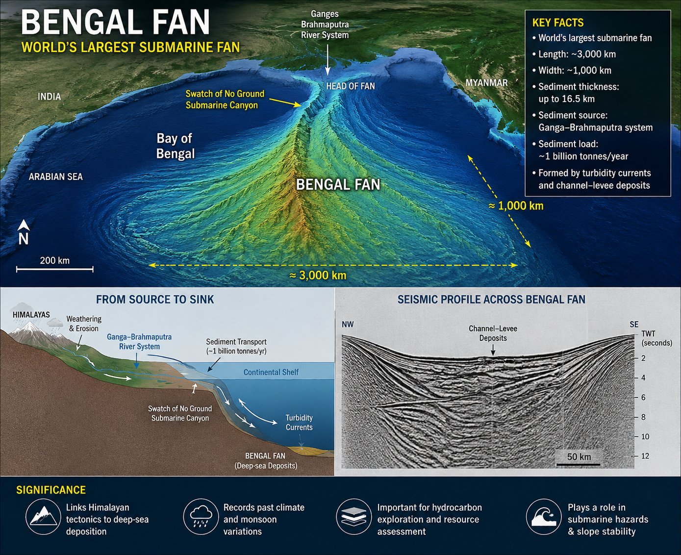
The Bengal Fan, also called the Ganges Fan, is the world’s largest submarine fan, stretching about 3,000 km long and ~1,000 km wide, with sediments reaching 16.5 km thickness.
It is a classic terrigenous oceanic deposit: the Ganga–Brahmaputra system transports ~1 billion tonnes of sediment annually, eroded largely from the Himalayas and Tibetan Plateau.
Sediments are funnelled through the Swatch of No Ground submarine canyon and carried thousands of kilometres into the deep Bay of Bengal by turbidity currents, forming channel–levee deposits.
Geographical significance: The Fan is a remarkable source-to-sink system, linking Himalayan erosion → river transport → submarine canyon → deep-sea deposition, thereby recording long-term tectonic, climatic and monsoonal changes.
Where to use ?
Paper I ( Oceanography ) : Oceanic deposits
Places in News - 24 August 2026
1. Zanskar Glacier
Why in news : A study published in The Cryosphere, examining 12 glaciers in the Zanskar Basin from 1992–2023, found that they are slowing and thinning due to climate change, with significant long-term implications for water availability in Zanskar and the wider Upper Indus basin.
About:
- Situated in the high-altitude Zanskar range of Ladakh, acting as massive natural freshwater reservoirs for the arid rain-shadow zone.
- Feeds the Doda and Zanskar rivers, which eventually join the Indus River. Glacier thinning reduces driving force and threatens long-term water security and summer river flows in the Indus Basin
2. Agasthyamalai Biosphere Reserve
Why in news : The Forest Department has issued eviction notices to thousands of households in the Agasthyamalai Biosphere Reserve (ABR), particularly in Tamil Nadu’s Theni district, following a Supreme Court directive based on the Central Empowered Committee (CEC) findings.
About:
- Located at the extreme southern end of the Western Ghats, spanning across Kerala and Tamil Nadu.
- Kalakkad-Mundanthurai Tiger Reserve and Neyyar sanctuary. It is a global biodiversity hotspot rich in endemic flora, traditional medicinal herbs (like Arogyapacha), and indigenous Kani tribes, and serves as the origin for perennial rivers like the Thamirabarani.
3. Gwalior
Why in news : Telecom Manufacturing Zone (TMZ) in Gwalior, Madhya Pradesh secured fresh investment commitments of Rs 2,000 crore, taking the total committed investment to Rs 5,500 crore.
About:
- Located in northern Madhya Pradesh, close to the Chambal region and situated on the historic Gopachal rock fortress hill
- Positioned on the Malwa-Chambal transitional geography, known for its historic defensive topography, unique local micro-watersheds, and growing status as a major urban and metropolitan node in central India.
4. Glaw Lake
Why in news : Glaw Lake in Arunachal Pradesh has been designated as India’s 101st Ramsar Site, and the state’s first wetland of international importance, taking India’s Ramsar network from 26 sites in 2014 to 101 in 2026.
About:
- Nestled at an elevation of roughly 1,168 meters inside the Kamlang Tiger Reserve and Wildlife Sanctuary in the Lohit district.
- High-altitude natural freshwater lake fed by high-ridge mountain streams, acting as the primary headwater source for the perennial Kamlang River and harboring rare alpine aquatic species like the critically endangered white-bellied heron
5. Shipki La Pass
Why in news : Cross-border trade between India and China through Shipki La Pass resumed on 1st August 2026, after a six-year suspension due to the Covid-19 pandemic.
About:
- Located at 3,930 meters in the Kinnaur district of Himachal Pradesh on the border with Tibet (China)
- Marked as a Line of Actual Control (LAC) post and historically an offshoot of the ancient Silk Road. Crucially, the Sutlej River (Langqen Zangbo in Tibet) enters India from the Tibetan plateau directly through this mountain gorge.

Fortnightly KOSMOS MCQs Practice - 24th August 2026
Q1. With reference to international trade and global supply chains, consider the following statements regarding 'Transshipment':
- Legitimate transshipment involves changing the physical transport vessel or mode at an intermediary hub without modifying the economic country of origin of the cargo.
- The practice becomes illegal when goods undergo minor paperwork changes, relabelling, or minimal assembly in a third country specifically to evade anti-dumping duties or tariffs.
- According to the recently released US White House report titled ‘The Great Transshipment Scam’, India has been classified under Tier 1 (Diversified Scale Leaders) owing to high transshipment risks.
Which of the statements given above are correct?
- 1 and 2 only
- 2 and 3 only
- 1 and 3 only
- 1, 2 and 3
Q2. With reference to 'Elephant Corridors' and elephant conservation in India, consider the following statements:
- Elephant corridors are legally protected entities automatically designated as 'Eco-Sensitive Zones' under the Environment (Protection) Act, 1982.
- According to the central government's recent mapping report, the Northeast region accounts for the highest number of elephant corridors in the country.
- The Asian Elephant is currently listed as 'Endangered' on the IUCN Red List and is protected under Schedule I of India's Wildlife (Protection) Act, 1972.
Which of the statements given above is/are correct?
- 1 and 2 only
- 3 only
- 2 and 3 only
- 1, 2 and 3
Q3. With reference to the European Union’s (EU) "Fit for 55" policy package, consider the following statements:
- The package introduces the Carbon Border Adjustment Mechanism (CBAM), which initially targets carbon-intensive imports such as iron, steel, cement, aluminum, and fertilizers.
- It aims to achieve complete economy-wide climate neutrality (net-zero emissions) for all EU member states by the year 2030.
- It includes legislative updates to the EU Emissions Trading System (ETS) to accelerate emissions reductions in sectors like maritime transport and aviation.
Which of the statements given above are correct?
- 1 and 2 only
- 2 and 3 only
- 1 and 3 only
- 1, 2 and 3
Q4. With reference to the celestial mechanics of a Solar Eclipse, consider the following statements:
- A solar eclipse does not occur on every New Moon day because the Moon’s orbital plane is inclined at an angle of about 5 degrees relative to the Earth’s ecliptic plane.
- During a total solar eclipse, the faint outermost layer of the solar atmosphere, known as the corona, becomes visible to the naked eye only within the path of the penumbra.
- An annular solar eclipse takes place when the Moon is near its perigee, causing it to appear larger than the Sun and leaving a bright 'ring of fire' visible.
Which of the statements given above is/are correct?
- 1 only
- 1 and 2 only
- 2 and 3 only
- 1, 2 and 3
Q5. With reference to the Indian Peafowl (Pavo cristatus), consider the following statements:
- The species is native only to India and Sri Lanka and is strictly confined to dense, tropical rainforest ecosystems.
- The vibrant, elongated "train" displayed by the male peacock during courtship is technically comprised of extended upper tail-coverts rather than actual tail feathers.
- It is classified as 'Least Concern' on the IUCN Red List and is granted the highest level of legal protection under Schedule I of India's Wildlife (Protection) Act, 1972.
Which of the statements given above are correct?
- 1 and 2 only
- 2 and 3 only
- 1 and 3 only
- 1, 2 and 3
Q6. Consider the following statements regarding the types of rights recognized under the Forest Rights Act, 2006:
- The Act recognizes both Individual Forest Rights (IFR) for habitation and self-cultivation, up to a maximum threshold of 4 hectares per nuclear family.
- For 'Other Traditional Forest Dwellers' (OTFDs) to qualify for rights under the Act, they must prove continuous habitation/dependence on the forest land for at least three generations (75 years) prior to December 13, 2005.
- Under Community Forest Rights (CFR), ownership over 'Minor Forest Produce' includes the right to collect, use, and dispose of both timber and non-timber forest resources.
Which of the statements given above are correct?
- 1 and 2 only
- 2 and 3 only
- 1 and 3 only
- 1, 2 and 3
Q7. With reference to the Barda Wildlife Sanctuary, which was recently in the news, consider the following statements:
- It is situated in the rocky, semi-arid terrain of the Barda Hills near the coastal city of Porbandar in Gujarat.
- The sanctuary acts as a natural tropical rainforest ecosystem that receives heavy monsoon rainfall from the Arabian Sea branch.
- The landscape is naturally drained by the Bileshvary and Joghri rivers, along with the Khambala and Fodara dams.
Which of the statements given above are correct?
- 1 and 2 only
- 2 and 3 only
- 1 and 3 only
- 1, 2 and 3
Q8. With reference to the Clouded Leopard (Neofelis nebulosa), consider the following statements:
- It is a highly arboreal species that possesses specialized ankle joints allowing it to climb down tree trunks headfirst.
- In India, its geographical distribution is restricted exclusively to the Western Ghats and the tropical rainforests of the Andaman Islands.
- It is currently classified as 'Vulnerable' on the IUCN Red List and is the state animal of the Indian state of Meghalaya.
Which of the statements given above are correct?
- 1 and 2 only
- 2 and 3 only
- 1 and 3 only
- 1, 2 and 3
Q9. Consider the following statements regarding the recently notified Glaw Lake (Glow Lake) Ramsar Site:
- It is the first wetland from Arunachal Pradesh to be recognized under the Ramsar Convention, bringing India's total tally of Ramsar sites past 100.
- The lake's surrounding landscape is highly unique as it ecologically supports all four major big cat species: the Bengal Tiger, Indian Leopard, Clouded Leopard, and Snow Leopard.
- Culturally, the lake and its catchment area are considered deeply sacred by the indigenous Mishmi and Meyor communities.
Which of the statements given above are correct?
- 1 and 2 only
- 2 and 3 only
- 1 and 3 only
- 1, 2 and 3
Q10. With reference to the 'Asan Wetland Conservation Reserve', which was recently in the news, consider the following statements:
- It is a human-made wetland ecosystem created by the construction of the Asan Barrage, which caused siltation and formed bird-friendly micro-habitats.
- Positioned strategically along the East Asian-Australasian Flyway, it hosts more than 1% of the global biogeographical population of the endangered Golden Mahseer fish.
- According to a recent Supreme Court directive, a mandatory 10-km buffer zone restricting unapproved mining activity around Asan has been extended to all wetland conservation reserves across India.
Which of the statements given above are correct?
- 1 and 2 only
- 2 and 3 only
- 1 and 3 only
- 1, 2 and 3
Share the article
Get Latest Updates on Offers, Event dates, and free Mentorship sessions.


Get in touch with our Expert Academic Counsellors 👋
FAQs
Geography Current Affairs focuses on the contemporary issues, events, and developments in the field of geography. It covers recent geographical phenomena, environmental changes, geopolitical shifts, and related news. This differs from regular geography studies which may focus more on foundational concepts, historical contexts, and theoretical frameworks.
Updates are provided regularly to ensure that subscribers stay informed about the latest developments in geography. Typically, updates are provided on a fortnightly basis, depending on the frequency of significant events and changes in the field.
Absolutely. Geography Current Affairs serves as a valuable resource not only for Geography optional but also for GS papers, especially GS Paper 1 (covering Indian Heritage and Culture, History, and Geography of the World and Society) and GS Paper 3 (covering Technology, Economic Development, Biodiversity, Environment, Security, and Disaster Management). It aids in building a holistic understanding of various topics and strengthens answer-writing skills by incorporating contemporary examples and perspectives.
Geography Current Affairs holds immense importance for UPSC preparation, particularly for aspirants opting for Geography optional. It helps candidates stay updated with the latest developments, geographical phenomena, environmental issues, and geopolitical shifts worldwide, aligning them with the dynamic nature of the subject as tested in the UPSC examinations.