07 May
Global Land Outlook 2 Report
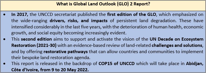
Why in news: Recently, the 2nd edition of Global Land Outlook (GLO) has been released by the United Nations Convention to Combat Desertification (UNCCD).
Five key takeaways from the UN’s milestone Global Land Outlook 2 Report:
- Humans have already transformed more than 70% of the Earth’s land area.
-
- Humans have already degraded nearly 40% and altered 70% of the Earth’s land from its natural state. This has caused unparalleled environmental degradation and contributed significantly to global warming.
- At least 20% of the global land surface is now degraded – an area the size of the African continent. However, other assessments put the proportion of land degraded at between 20 and 40%.
- Degradation is “particularly acute” in dryland regions, which are today home to one in three people. Drylands is a collective term for water-scarce parts of the world, including arid, semi-arid and dry sub-humid areas. The UNCCD defines desertification as land degradation in these areas.
- Breach of planetary boundaries: The report says that of the nine “planetary boundaries” – limits on how humans can safely use Earth’s resources – four have already been exceeded: climate change, biodiversity loss, land use change and bio-geochemical cycles. These breaches are directly linked to human-induced desertification, land degradation and drought.
- On land-use change, the report says that 5-10 million hectares (mha) of forest were razed every year between 2000 and 2015, leading to a total global loss of 125mha.


- Food systems are responsible for 80% of deforestation, 29% of greenhouse gas emissions and are the single largest cause of biodiversity loss on land.
-
- At least 40% of the Earth’s land surface is dedicated to agriculture, and more than half of these lands are degraded.
- Current impacts of food production on nature:

-
- Agriculture led deforestation around the world is largely driven by – lack of sufficient regulations, short-sighted national development priorities, lax enforcement of existing regulations and ultimately, consumer demand in developed countries.
- In addition, land degradation by food systems is not limited to deforestation. Agricultural expansion and climate change pose the “greatest threats” to grasslands, which make up more than two-thirds of the land being converted to cropland in wet regions of the planet.
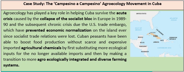
- Suggestions by the report for transforming food systems:
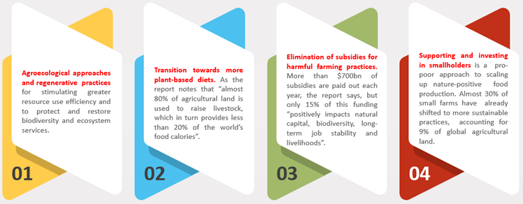
3. Protecting and restoring ecosystems could aid to achieve global warming goals.
- Protecting and restoring land resources reduces emissions and sequesters carbon, providing more than one-third of the cost-effective, land-based climate mitigation needed between now and 2030 to stabilize warming.
- In addition to its mitigation potential, land-based climate solutions enhance adaptation through:
- Effective management and expansion of networks of conserved and protected areas.
- Sustainable land and water management practices in working rural landscapes.
- Ecological restoration or rewilding of biodiversity and well-functioning ecosystems.

![]()
- While terrestrial and oceanic sinks have removed over half of the carbon emissions generated from human activities, the rate of sequestration is now declining. If land degradation continues unabated, this could potentially trigger a reversal from land being a net sink to being a net source.
- Land restoration offers numerous pathways to reduce emissions, sequester carbon, and enhance human and environmental resilience to cope with the expected impacts of climate change.
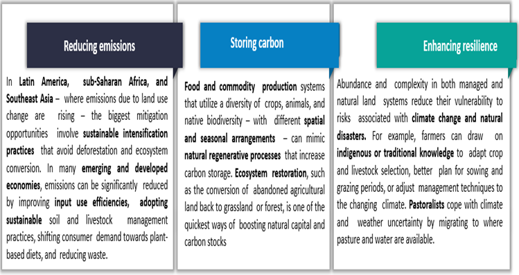
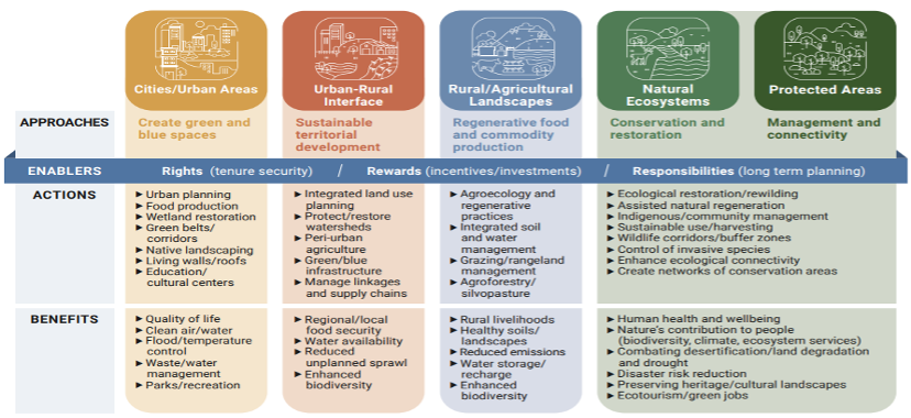
- Place-based restoration approaches: The report provided for several place-based restoration approaches along with actions and their benefits.
- Land degradation threatens marginalized communities the most – but these groups have much to contribute to ecosystem restoration and protection.
-
- More than 3 billion people are already living with the impacts of desertification, land degradation and drought. These are mostly poor rural communities, small-scale farmers, women, youth, Indigenous peoples and other at-risk groups.
- Indigenous peoples represent around 6% of the global population, but they have tenure rights over about one-quarter of the Earth’s surface, and 40% of intact ecosystems and protected areas.
- However, Indigenous peoples have also been frequently forced from their lands and subjected to discrimination, which often severely curtailed their fundamental rights and freedoms.
- Land back movement: The report discussed the land back movement as a growing push for indigenous communities to reclaim their ancestral lands. It states – “It offers many opportunities for the restoration of traditional, regenerative land and water management practices, which could be applied throughout large parks, public lands, and protected areas. The movement is aligned with global campaigns to protect biodiversity, expand Indigenous management of protected areas and restore natural capital to mitigate and adapt to climate change.”

-
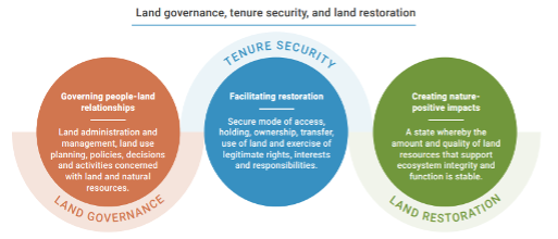
- Rights based approaches to land restoration: As proven land stewards, indigenous peoples and local communities will be vital to the success of the global land restoration agenda, but only if their rights are recognized and they are involved in the management of protected areas. Indigenous and local knowledge, customary use, and management practices must be given equal footing alongside modern scientific approaches.
-
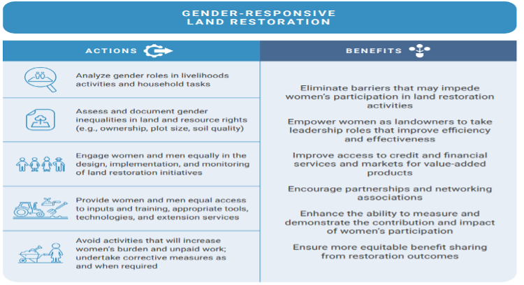
- Gender-responsive land restoration: The gender-responsive land restoration is an obvious pathway to reduce poverty, hunger, and malnutrition. It ensures that women and men have an equal voice and influence in land use and management decisions and their outcomes.
-
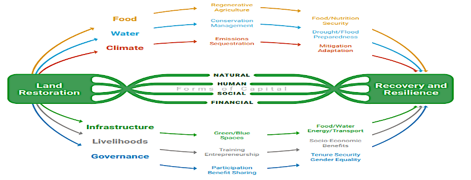
- Synthesis of different forms of capital: Land restoration is efficient, effective, and equitable when people are front and center. Restoration projects can have even greater impacts when they are employed in tandem with poverty alleviation, disaster risk reduction, healthcare and rural development strategies. Thus, greater investments in human and social capital will help maximize the impact of financial capital when undertaking land restoration activities.
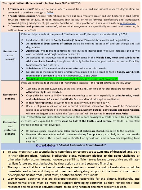
- The world faces a stark choice between protecting and restoring land and ‘business as usual’
Sources:
Protecting the Endangered and Threatened Species of India
Why in News?
The recent Species Threat Abatement and Recovery (STAR) score released by IUCN has revealed that Kerala, Tamil Nadu and Karnataka account for about 51% of the country’s threatened and endemic species of amphibians, birds and mammals.
Species Threat Abatement and Restoration (STAR) score:
- STAR score is a measure of the contribution that investments can make to reduce species extinction risk.
- Aim: It helps national and subnational governments, cities and other entities target their investments and activities to achieve conservation outcomes.
- Objective: It identifies which threats are negatively affecting which species in each state and where habitat restoration will yield the maximum returns for individual species.
- Global STAR score: The global STAR score for the three species groups (mammals, birds and amphibians) combined was 1,223,500 of which India's score represented 3.4% (3.7% for mammals, 2.9% for birds and 3.6% for amphibians).
- India’s score contributors:
- The top 20% of all 36 states and UTs (28 states and 8 Union territories) contributed 80% to the national STAR score. These include Kerala (20%), Tamil Nadu (18%), Karnataka (13%), Arunachal Pradesh (6%), Assam (5%), Maharashtra (5%) and the Andaman and Nicobar Islands (12%).
- The high STAR scores of the top three states were primarily due to the presence of a number of endemic amphibian species that are critically endangered like Indirana phrynoderma(Kerala Indian frog), Fejervarya murthii (Ghats wart frog),
- The high scores of the northeastern states of Arunachal Pradesh and Assam were due to the presence of a high number of threatened birds and mammals such as Liocichla bugunorumand Biswamoyopterus biswasi.
- In contrast, the 20 states with lower STAR scores contributed only 6% to national STAR score. This is because several of them are small in area and host few threatened species.
- Several bigger states such as Uttar Pradesh, Bihar, Odisha and Telangana, have contributed less than 1% to the national STAR score.
- The top 20% of all 36 states and UTs (28 states and 8 Union territories) contributed 80% to the national STAR score. These include Kerala (20%), Tamil Nadu (18%), Karnataka (13%), Arunachal Pradesh (6%), Assam (5%), Maharashtra (5%) and the Andaman and Nicobar Islands (12%).

Why are the species facing increased Risks?
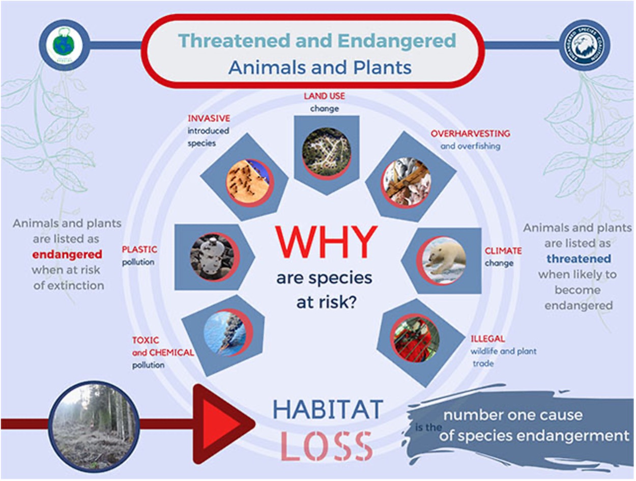
- This is because of the fact that the illicit demand, globally, for wildlife and its products has rampantly increased. This has led to a rise of wildlife crime across the subcontinent.
- Wildlife crime refers to acts committed contrary to national laws and regulations intended to protect natural resources and to administer their management and use.
- This includes the illicit exploitation of natural resources, such as poaching of animals and unauthorized logging of trees.
- It may also include subsequent acts, such as the processing of fauna and flora into products, their transportation, sale and possession.
Wildlife Crime in India:
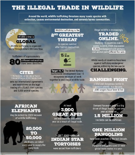
- In India, wildlife crime is a pervasive problem damaging ecosystems, impacting food security and affecting livelihoods of rural communities.
- In many cases, cross-border smuggling of live animals and plants can result in the spread of disease through carrier animals and plants.
- Major wildlife crime in India includes poaching of tigers, rhinos and the sale of Star tortoises.
- Alongside, many protected marine species such as sea cucumbers, molluscs, sea horses and coral are also illegally harvested in Indian waters for export.
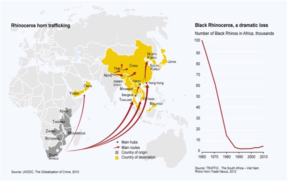
- Routes for smuggling: Ancient trade routes for salt, spices and wool are being used to smuggle tiger skins and bones.
- The main route is via Nepal, with whom India has a porous border, or directly across the border to China. More recently, routes through Myanmar have also been used.
- The Indian rhino is smuggled from Pakistan, all the way through India, Nepal, Bangladesh, Bhutan and Myanmar.
Legal Provisions to Encounter the Illegal Trade:
- In India, the Wildlife (Protection) Act, 1972 is a strong legislation that covers wildlife crime. Protected Areas, viz., National Parks, Sanctuaries, Conservation Reserves and Community Reserves have been created.
- Financial and technical assistance is provided to the State/ Union Territory Governments under the Centrally Sponsored Schemes of ‘Integrated Development of Wildlife Habitats', ‘Project Tiger’ and ‘Project Elephant’ for providing better protection to wildlife, and improvement of its habitat.
- The MoEFCC also provides financial assistance to State Governments for undertaking “Recovery Programmes for saving critically endangered species” as a component of the ‘Integrated Development of Wildlife Habitats’.
- At present, sixteen species have been prioritized for taking up such recovery programmes which include Snow Leopard, Bustards, River Dolphin, Hangul, Asian Wild Buffalo, Nicobar Megapode, Manipur Brow-antlered deer, Vultures, Malabar civet, the great one-horned rhinoceros, Asiatic Lion etc.
Source:
- Large share of India’s threatened endemic species in Kerala, Tamil Nadu and Karnataka: Study
- India: Our endangered wildlife - a cause for concern
- Steps Taken for Protection of Endangered Species
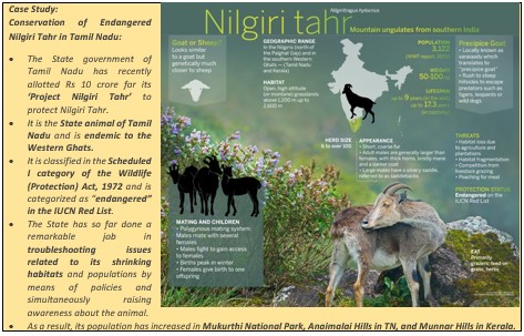
- Special project to protect endangered Nilgiri Tahr
Image Source:
Use of Technology to tackle Urban Problems
In News: The 25th session of the UN Commission on Science and Technology for Development (CSTD) has been scheduled to examine the ways to leverage science, technology and innovation for sustainable urban development in a post-pandemic world.
Urban Areas and possible solution to tackle them:
- With more than half of the world’s population currently living in urban areas being expected to rise to 5 billion people by 2050, which is two thirds of all humanity, there is an expected proportional increase in the sustainability challenges facing these urban regions.
- The already existing sustainability challenges has further been exacerbated by adversities like the COVID-19
- For instance, the use of masks and other disposable plastics has significantly increased urban plastic pollution and inappropriate waste management practices.
- Addressing these problems immediately yet innovatively is the need of the hour for which rapid technological change has been recommended as it opens new possibilities to tackle urban problems at a lower cost and with more sustainability.
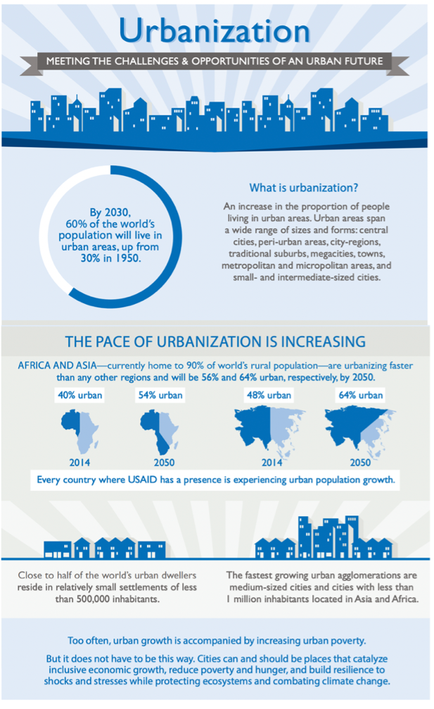
Role of Technology in solving Urban Problems:
- Of late, whether it is issues with energy, transport, health, inequality, the environment – technology has long been touted as the answer.
- When innovation in IT has irrevocably changed people’s lives – the same should work for cities too.
- Fortunately, the expansion of our cities is being matched by increasing investment in and widespread deployment of smart technology.
- In today’s digital era, smart technology enabled by the Internet of Things (IoT)is able to address a number of challenges facing our cities.

Smart City Concept: Application of Technology towards Sustainable Urbanisation
- The Smart City concept uses different types of data collection sensors to track information to manage assets and resources more efficiently.
- Some monitored items include traffic and transportation systems, air quality, waste management, hospitals, law enforcement, schools and libraries.
- The data collected from technology is then analyzed for making improvements and responding to urban challenges.
1. Transportation:
- One of the biggest challenges cities contend with is traffic and congestion. An often-cited study performed by IBM in 2011 estimated that over 30% of traffic in a city is caused by drivers searching for a parking spots.
- A Smart City solution includes installing lighted sensors, like Park Assist to guide drivers in a quick and easy manner to parking spaces that are available in real time.
2. Energy Infrastructure:
- Integrating smart technology into existing energy infrastructure will help meet rising urban demand for energy along with making energy generation cleaner.
- IoT enabled technology, such as smart grids, can monitor real-time energy demand and autonomously adjust the energy supply as needed.
- Making the energy system smart will increase efficiency and save huge energy
- Smart energy system using the IoT include programmes that is involved investigating whether renewable technology, such as solar panels and batteries.
3. Harnessing big data in healthcare:
- The integration of smart technology in healthcare is set to transform how care is provided, with a significant shift from treatment to prevention.
- By applying machine learning and artificial intelligence to patient databases, it is now possible to make sense of trends and determine patterns which are linked to specific illnesses.
- For example, there are certain digital solutions that can identify people who are susceptible to Type 2 diabetes and give them personalised lifestyle goals, such as weight loss programmes, as a preventive course of action.
- Using smart technology to predict and pre-emptively treat patients will enable healthcare services to save both time and money.

Fig: Big data usage in decision making
4. Disaster Management:
- Satellites are one among the technologies that hold promise for tackling urban sustainability challenges.
- It can address urban development issues such as planning and the control of new population settlements through which it can ensure basic services such as water supply, energy, garbage collection etc which will lead to further development.
- It helps the authorities in urban areas identify vulnerability to natural hazards such as flooding, sea level rise, large fires, volcanic eruptions and tsunamis.
- They also provide data to mitigate the impact of these disasters by giving a synoptic view of affected areas, helping relief teams identify worst-hit areas and paths to reach and support victims.
- They monitor air quality in urban areas.

Case Study:
- Singapore has been ambitiously working to become the world’s first true Smart Nation by harnessing technology to the fullest with the aim of improving the quality of life, strengthening businesses and building stronger opportunities.
- It has already begun its journey to bring about the vision it calls ‘E3A’: Everyone, Everything, Everywhere, All the time.
- The Smart Nation Platform has enable greater connectivity, better situational awareness through data collection, and efficient sharing of collected sensor data.
Source:
- Smart Cities: Solving Urban Challenges with Technology
- How intelligent tech is solving the challenges of urbanisation
- International Case Studies of Smart Cities
- Promoting use of technology to tackle urban problems
Image source:
Juvenile water
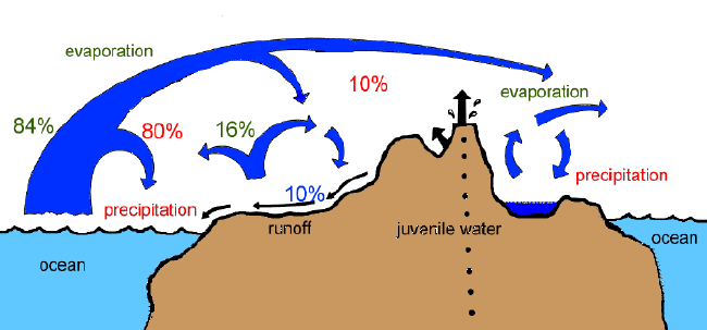
- Juvenile water also known as Magmatic water is “new” water that originates from the interior of the Earth and has not previously existed as water in any state.
- The term was coined by Meinzer, who contrasted juvenile with meteoric water.
- Meteoric/groundwater is water with an atmospheric or surface origin.
- Juvenile water is found in cracks or crevices or porous rocks due to condensation of steam coming out of hot molten masses or magma existing below the earth surface.
- It is released to the atmosphere during volcaniceruption and gets added to water cycle for first time.
- It plays a key role in assessing the crystallization of igneous rocks, particularly
- Juvenile waters have deep origin and are often the primary producers of deep warm mineral water.
Source:
Image source:
Hoodoo
- Hoodoo is an erosional landform of arid and desert region.
- Hoodoois a tall, irregularly shaped rock formation. Hoodoos are tall like a pillar or column, but do not maintain the same form from top to bottom.
- Hard rocks and soft rocks (like mudstone) lie in horizontal strata upon one another. Wind, rain and freezing temperatures can erode soft rock layers from the side. Cracks in the top layer can allow water to seep through and divide larger formations by erosion. The last portion to remain may be in the form of a pinnacle or a hoodoo, protected on top by a cap of limestone or hard rock.
- It can be smaller than a metre or as high as a 10-story building.
- Utah (USA) has the greatest concentration of hoodoos, other regions include France, Turkey, Serbia, New Zealand, Taiwan, and Alberta-Canada.
- Some famous hoodoos are Queen’s Garden and Thor’s Hammer, Bryce Canyon National Park, Colorado, USA.

Source:
Image source :
Radiative Forcing
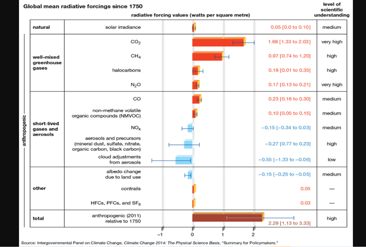
- Radiative forcing(or climate forcing) is the change in energy flux in the atmosphere caused by natural or anthropogenic factors of climate change and is measured by watts / metre2.
- Climatic factors are classified based on those caused primarily by human activity (such as greenhouse gasemissions and aerosol emissions) and those caused by natural forces (such as solar irradiance).
- “Positive radiative forcing” exerted by climatic factors contribute to the warming of Earth’s surface, whereas “negative forcing” is exerted by factors that cool Earth’s surface.
- Temperatures at the earth surface may also rise or fall through a change in the distribution of terrestrial radiation (i.e. radiation emitted by Earth) within the atmosphere.
- When all values of positive and negative radiative forcing are taken together and all interactions between climatic factors are accounted for, the total net increase in surface radiation due to human activities since the beginning of the Industrial Revolutionis 1.6 watts per square metre.
- Because of increase in positive radiative forcing factors like Black carbon , Blue carbon and aerosols in Himalayan region, the glaciers are melting at alarming rate.
Source :
Image Source:
The Thames River from being ‘biologically dead’ to one of the world’s cleanest rivers
Problem Statement: India has been trying to clean its most of the rivers including the Ganga and the Yamuna. However, so far no remarkable progress could be achieved. Here the example of Thames River in England offers a fantastic example to replicate.
The Thames River: Geographical Course of the river
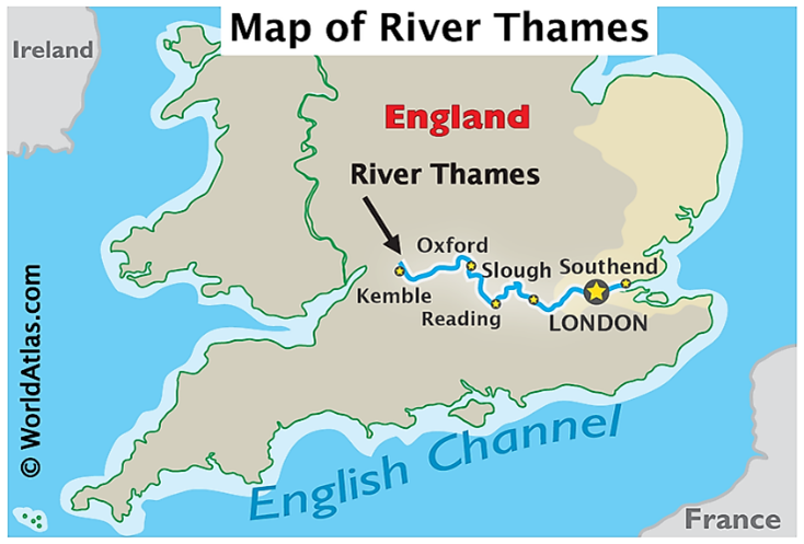
- The River Thames, known alternatively in parts as the River Isis, is a river that flows through southern England, including London. It is the longest river entirely in England and the second-longest in the United Kingdom, after the River Severn.
- The Thames runs for over 360 km from Kemble in Gloucestershire to Southend-on-Sea in Essex, where it flows into the North Sea. Where it bisects London, it has experienced pressures from expanding numbers of city dwellers since medieval times.
The water Quality of Thames River 60 years back
- The river became a repository for waste, with leaking cesspits and dumped rubbish reducing many of its tributaries to running sewers. Many of these small rivers now lie underneath the streets of London, long covered up to hide their foul smells: the Fleet, which runs from Hampstead and enters the Thames at Blackfriars, is probably the best known.
- Measurements taken during the 1950s showed that dissolved oxygen levels in the Thames were at just 5% saturation: the rough equivalent of 0.5 mg/l. That meant the river could only support a few aquatic invertebrate species like midges and fly larvae.
- For the 20 miles of the Thames running through central London, dissolved oxygen levels were not even measurable. And from Kew to Gravesend, a 69 km length of river, no fish were recorded in the 1950s. Surveys in 1957 found the river was unable to sustain life, and the River Thames was eventually declared “biologically dead”.
Actions Taken
- From 1976, all sewage entering the Thames was treated, and legislation between 1961 and 1995 helped to raise water quality standards.
- The privatisation of water companies under British Prime Minister Margaret Thatcher also saw the establishment of the protective National Rivers Authority in 1989, as well as the introduction of biotic monitoring.
- This is a clever scoring system that measures pollution by counting the macroinvertebrates – such as mayfly, snails or water beetles – found in a river, then giving each species a score according to its tolerance to low dissolved oxygen levels.
- Low overall scores mean that the river is not as capable of sustaining organisms that need oxygen, so is less healthy.
- The installation of large oxygenators, or “bubblers”, to increase dissolved oxygen levels. The Thames Water Authority developed a prototype oxygenator based on a river barge in the early 1980s. This was replaced by a self-powered “Thames Bubbler” in 1988, and a third vessel was launched in 1999. Together, they are responsible for maintaining oxygen at a level sufficient to support growing fish populations.
Results – Success of River Cleaning Efforts
The flounder was officially the first fish species to return to the Thames in 1967, followed by 19 freshwater fish and 92 marine species such as bass and eel into the estuary and lower Thames. The return of salmon during the 1980s was a thrilling marker for conservationists, and today around 125 species of fish are regularly recorded, with exotic species like seahorses even being occasionally sighted.
Source:
Places in News - Pakke Tiger Reserve
|
Pakke Tiger Reserve
|
|
Khandwa
|
|
Cardamom Hills
|
|
Samba
|
|
Anang Tal Lake
|
|
Painganga Wildlife Sanctuary
|

Share the article
Get Latest Updates on Offers, Event dates, and free Mentorship sessions.

Get in touch with our Expert Academic Counsellors 👋
FAQs
Geography Current Affairs focuses on the contemporary issues, events, and developments in the field of geography. It covers recent geographical phenomena, environmental changes, geopolitical shifts, and related news. This differs from regular geography studies which may focus more on foundational concepts, historical contexts, and theoretical frameworks.
Updates are provided regularly to ensure that subscribers stay informed about the latest developments in geography. Typically, updates are provided on a fortnightly basis, depending on the frequency of significant events and changes in the field.
Absolutely. Geography Current Affairs serves as a valuable resource not only for Geography optional but also for GS papers, especially GS Paper 1 (covering Indian Heritage and Culture, History, and Geography of the World and Society) and GS Paper 3 (covering Technology, Economic Development, Biodiversity, Environment, Security, and Disaster Management). It aids in building a holistic understanding of various topics and strengthens answer-writing skills by incorporating contemporary examples and perspectives.
Geography Current Affairs holds immense importance for UPSC preparation, particularly for aspirants opting for Geography optional. It helps candidates stay updated with the latest developments, geographical phenomena, environmental issues, and geopolitical shifts worldwide, aligning them with the dynamic nature of the subject as tested in the UPSC examinations.

