10 Apr
RAVAGING FOREST FIRES ACROSS THE GLOBE
Why in news?: Forest Survey of India reveals that Odisha is experiencing the country’s worst forest fires, with 642 incidents alone in month of March.
Background:
- Forest fires have occurred across the globe at various times in the The sources of these fires have been both natural and anthropogenic.
- Forest areas in North America, South and S E Asia, Australia, Africa and Amazonia are prone to the incidence of fires regularly.
- Forest fires occur almost on an annual basis in the deciduous forests of Southern India.
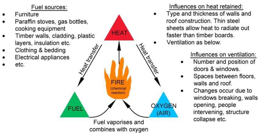
- To get a forest fire starting, three elements must be contemporarily present: a heat source, fuel and oxygen. If one of the three elements is not present (anymore), the combustion reaction cannot start.
Types of Forest fires:
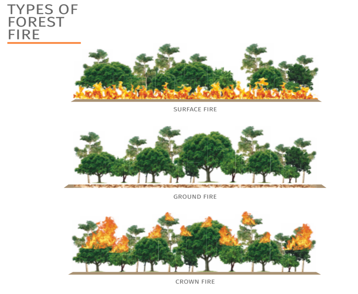
Forest fire broadly classified into three categories:
- Surface fire : Spread with flaming front and burn leaf litter, fallen branches and other fuels located at ground level.
- Ground fire: Burning of organic matter in soil beneath the surface litter and are sustained by glowing combustion.
- Crown fire: Burn through the top layer of foliage on a tree , known as the canopy or crown fires.They are the most intense and difficult to contain
Natural Causes of Forest Fires
- Volcanic Eruption : Extreme heat of lava may cause vegetation to catch fire and spread. Mauna Ulu eruption in Hawai in 1970s burnt the Naulu forest.
- Lightning : Forest fires frequently happens when lightning bolts continue for an abnormally long time or when they strike a dry material. In 2022, 90% of forest fires in boreal forest of Northern Canada and Alaska triggered by lightning.
- High atmospheric temperatures: High temperature and dryness offer favourable conditions for fire because of lack of moisture. In 2022, fires triggered in Arctic forests due to rising temperatures.
- Dry bamboos : In bamboo areas, forest fires may occur by rubbing together of clumps of dry bamboos. Bamboo bushes in Kakatiya Van Vihar in Telengana caught fire recently.
- El Niño conditions : El Niño , causing extreme dry conditions triggered one of the most severe fire seasons in 2015 in Indonesia.
Anthropogenic causes
- Shifting cultivation : Shifting agriculture is the dominant driver of forest disturbance in India, especially in North Eastern states.
- To get god grass/ fodder crop : In the upper Himalayan mountain, areas where natural forests still exist , massive fires are set intentionally to get fodder for animals.
- Flush for tendu leaves : In central India, fires are ignited in the forest to increase the production of tendu leaves. Tendu leaves collectors set fires in the summer months to promote a better flush of leaves.
- To conceal illicit felling : Smugglers and poachers in jungles of Odisha are caught many times setting forest fires to hide the stumps of illicit felling. The poachers use forest fires for terrorising wild animals and hunting too.
- Burning farm residue: After harvest, farmers in Haryana , Punjab , UP and Bihar set fire to their agricultural fields. Many times, when these fires are not put out completely, may spread to the adjoining forest areas.
- Protecting crops from wild animals : Villagers residing in or near the forest many times light up the fire in the forest to keep the wild animals away from their crops and cattle.
- Careless travelling : Travellers, picnickers, nomadic grazers, villagers or even forest labourers some time throw un-extinguished cigarettes, bidis, and match sticks in the forest areas. In 2012 , Israeli tourist was arrested for causing forest fire in Chile.

Benefits of Forest fires
- Cleaning the Forest Floor : With the help of fire low-growing underbrush is burned off, the forest floor is cleared of debris, the forest gets exposed to sunshine, and the soil is nourished.
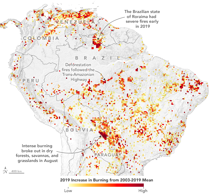
- Promotes biodiversity : The heavy brush is removed from wildlands by fire, making way for fresh grasses, herbs, and regenerated shrubs that provide food and Habitat for various wildlife species.
- Killing Disease : Fire destroys diseases and pests that harm trees while supplying essential nutrients for soil improvement. Rather than fire, Disease and insect infestation claim the lives of more trees each year.
- New Generations : Some trees have bark that can withstand fires and cones that must be heated to open and release seeds for regrowth. Manzanita, chamise, and scrub oak are examples of chaparral plants that also need a lot of heat to germinate their seeds.
- Fire prevents fire : Regularly occurring small wildfires actually prevent bigger, more destructive fires from happening in the future. If a forest doesn’t have a burn for a long time, dead trees and other fuel builds up, causing a much more destructive, out-of-control fire later.
Adverse impacts of forest fires
- Pollution : The Hyderabad-based NRSC study revealed that concentrations of trace gases and aerosols rose to alarming levels in Uttarakhand p during a massive fire in April-May 2016.
- Deteriorated Water quality : The introduction of fire retardant chemicals into waterbodies can reach levels toxic to aquatic organisms, as seen in Mexico.
- Health & illnesses : Smoke from fires set in the Amazon region is one of the key causes of respiratory hospitalisations of indigenous people, states in study.
- Loss of resources : The planet continues to experience a massive loss in forest land. The U.S. has lost 29.7 million acres of tree cover from forest fires since 2001.
The U.S. has lost 29.7 million acres of tree cover from forest fires since 2001.
- Disruption of carbon cycle : Forest fire caused the loss of carbon sequestered in forest biomass carbon stock. In the future, due to climate change, a greater number of forest fire events may occur and disturb the carbon cycle.
- Damage to flora and fauna : Forest causes severe threat to flora and fauna. Mammals, reptiles, birds and frogs died in the forest fires every year.
- Soil erosion: In Portugal, as well as in other Mediterranean countries, forest fires has caused soil erosion . Vegetation cover is an important factor in determining runoff and erosion risk.
- Depleting ozone layer : Forest fires in Australia continued from June 2019 to March 2020, and released over 1 million tonnes of smoke that reached to the stratosphere and affected the ozone layer.
- Microclimate change : The changed microclimate caused by the removal of litter and duff, opening of the canopy by killing over storey shrubs and trees and darkening of the soil surface by residual soot and charcoal can increase insulation causing temperature increase.
Status of Forest fires across the globe
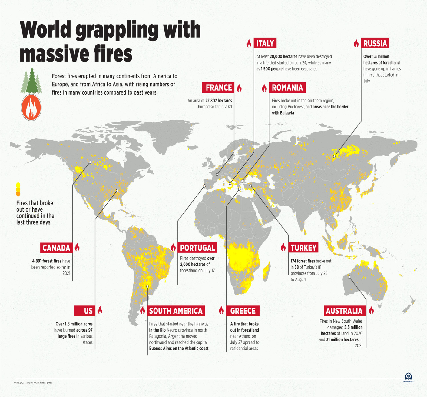
- Most of North and South America, the African plateau, the northern Arabian Peninsula, and the Mediterranean coast of Europe as well as Northern and Eastern Europe have been affected by fires.
- In Asia, fires have been detected on the coasts of India and in Russia's Siberia region as well as in China, Malaysia and Indonesia.
- European countries with Mediterranean coasts such as Italy, Spain, and Greece are also struggling with forest fires.
Status of Forest Fires in India
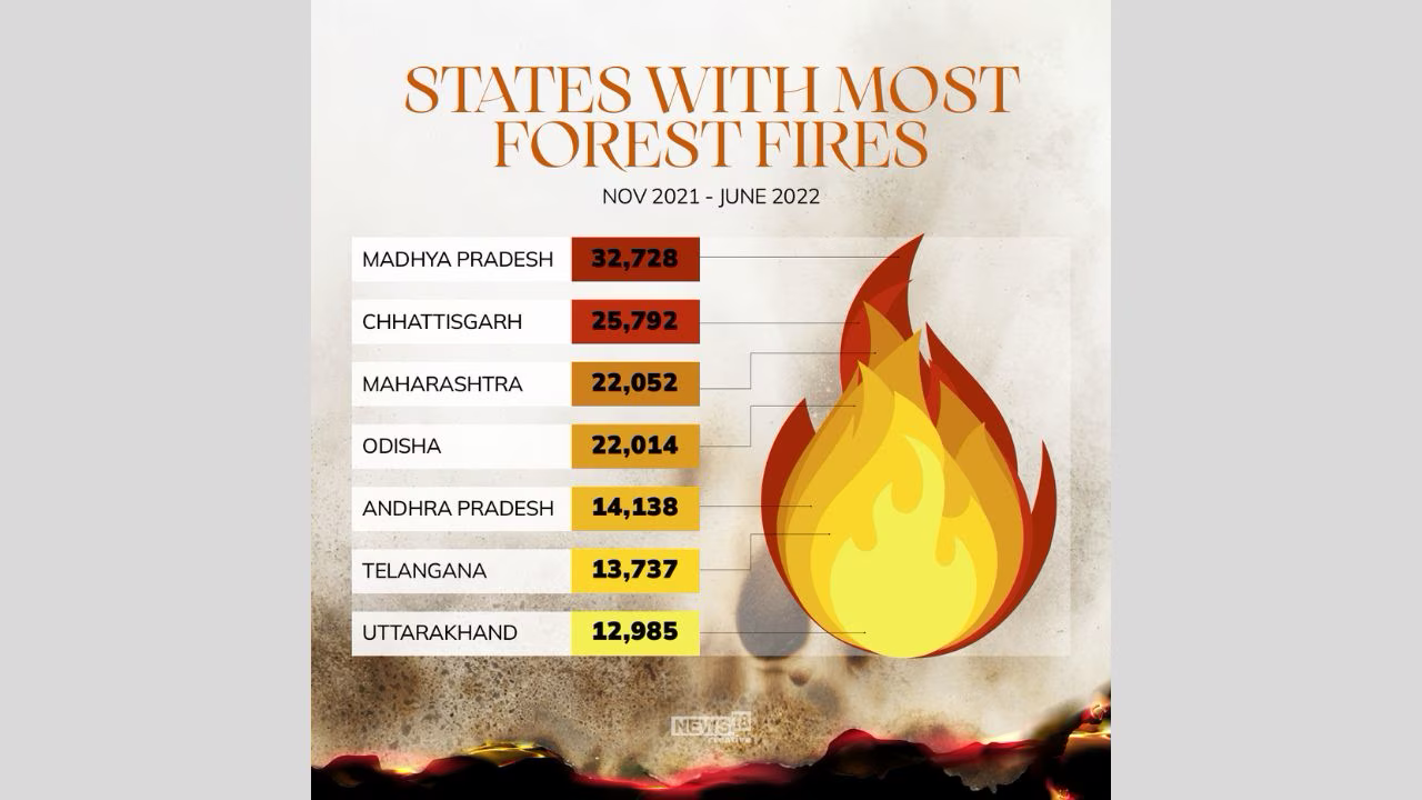
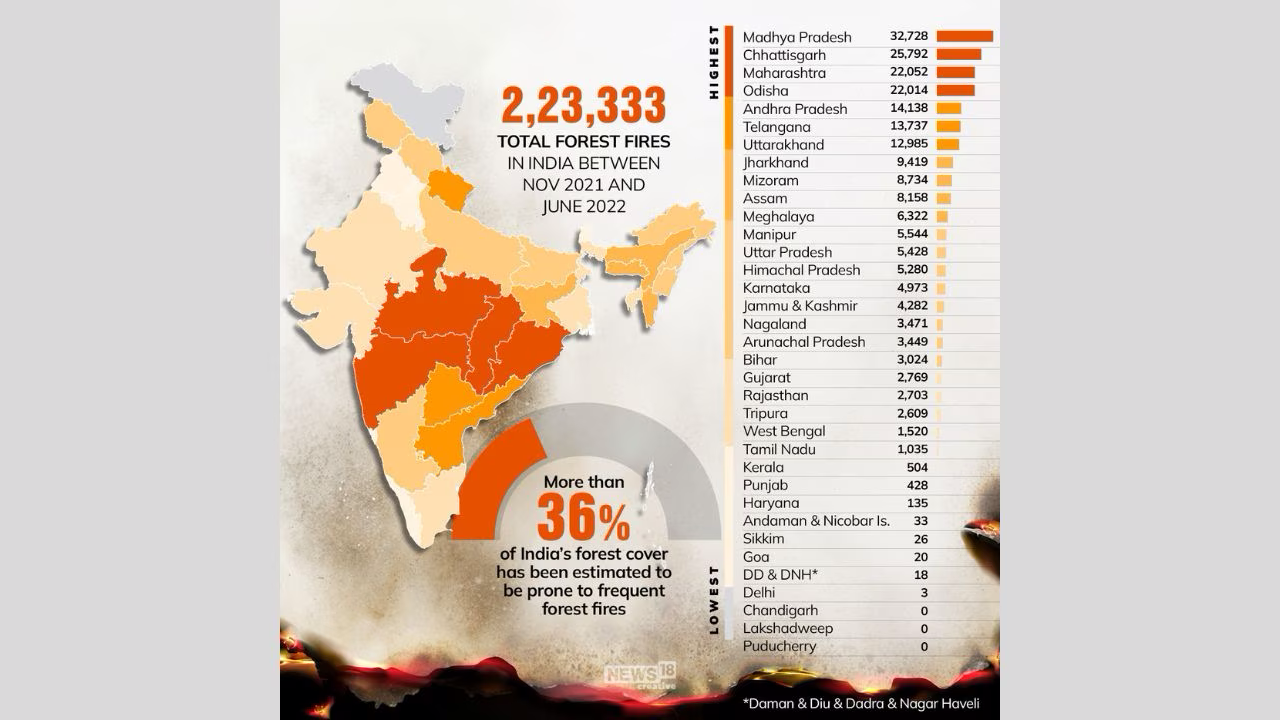
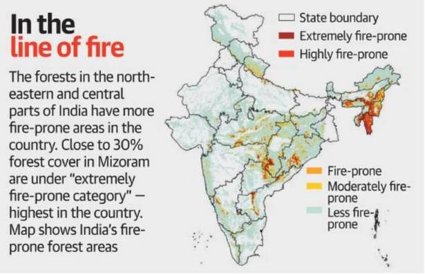
- According to Forest Survey of India website , there are 337 large Forest fires in the country as of March 14 in this year with 38 in Arunachal Pradesh, 18 in Jharkhand, 16 in Manipur, 15 in Meghalaya, 44 in Mizoram and 147 in Odisha, among others
- The forest fires in Odishacome in the backdrop of the state not receiving any rain since October, which has resulted in forests experiencing dryness and the forest fires spreading.
- Andhra Pradesh, Assam, Chhattisgarh, Odisha and Maharashtra are the most prone to high-intensity forest fire events caused by rapid change in climate.
- Mizoram had the highest number of forest fire incidences in the last two decades, with more than 95% of its districts being forest fire hotspots.
- Earlier, forest fires would take place during the summer months, that is between May and June. Now, during spring, between March and May, because of climatic changes.
- The duration that forest fires could take place was two to three months earlier, but it is now nearly six months.
Instances of Forest fires in India in 2023
- The Himachal Pradesh and Nagaland-Manipur border saw prolonged fires in January.
- There was a major wildfire between February and March in the Simlipal National Park in Odisha.
- According to the Indian Express, Southern Chhattisgarh, Central Odisha, Western Maharashtra, and areas of Andhra Pradesh and Telangana are highly prone to forest fires.
- Bandhavgarh Forest Reservein Madhya Pradesh and sanctuaries in Gujarat also witnessed forest fires.
Government Initiatives to prevent Forest Fires in India
- The National Forest Policy of Government of India, 1952 states that the claims of the communities residing near forests should not override national interest. This was done in order to protect the forests from incessant exploitation, thus cultivation and other related activities were allowed only in unclassified forest land.
- National Mission for Green India, introduced in 2014 aims at protecting and enhancing the forest cover of the country by involving the local communities in planning and decision-making of the same.
- Compensatory Afforestation Fund Management and Planning Authority (CAMPA) was introduced in 2014, to check the usage of unspent money raised by the central and the state governments.
- The Central Government is also providing assistance to the State Governments under the centrally sponsored scheme – the National Afforestation Program (NAP) “for regeneration of degraded forests and adjoining areas through people’s participation.
- Since 2004, the Forest Survey of India(FSI) developed a Fire Alert System. The system will monitor forest fires in real-time. In 2019, an advanced version of the system was also launched.
- Using the MODIS sensors(Moderate Resolution Imaging Spectroradiometer) Real-time fire information of fire hotspots is collected and sent to FSI. This is then forwarded by email to state, district, circle, division, range and beat levels. People in the locality will also receive SMS alerts.
Council on Energy, Environment and Water Recommendations for Managing Forest Fires
- Recognise forest fires as a disaster type and integrate them into national, sub-national and local disaster management plans.
- Develop a forest fire- alert system, which does not segregate forest fires from other fires such as waste burning and crop burning.
- Enhance adaptive capacity with training on high technology-focused equipment (like drones) and nature-based modules such as creating effective forest fire lines.
- Provide clean air shelters in public buildings or government schools to create clean air shelters for communities worst impacted by fires and smoke from forest fires.
Way forward:
- Revision of Indian Forest Act with some relevant section needs to be revised to give due importance to legal protection against man-made forest fire.
- Designing and installing a network of fire forecasting at National and State levels in collaboration with the Meteorological Department.
- International coordination along with organising seminars, training programs, conferences, and study tours in different countries leading in Forest Fire Management, e.g., U.S.A., Australia, U.K., Spain, France, etc.
- Need to work on a new system of issuing pre-fire alerts to prevent such incidents.
- Designing syllabus for planning, management, ground level firefighting courses in Forestry Institutions.
- Promotion of people’s participation through involvement of NGOs, Voluntary Organisations, Village Forest Committees (VFCs)
- Creation of forest self-help groups (FSHGs) or local forest special purpose vehicles (FSPV) — with an industrial linkage to the removal of dry needles with the help of villagers.
- Set up National Institute of Forest Fire Management with satellite centres in different parts of India with an objective to bring the latest forest fire fighting technologies to India through proper research, training of personnel etc.
Conclusion:
Forest fires have been a local issue with global impact, which may happen more frequently than the recent past due to impact of rising temperature and global warming. As populations grow with expansion of industrial development into forested areas and climate change alters fire regimes, the risk to communities and infrastructure will likely increase. Mischievous fires originated from villages near the forest areas are the major causal factors for fire incidences. Therefore, sensitisation of people and their social awakening through various meeting with villagers/ settlers and awareness campaigns about the negative consequences of forest fires on their health, environment and degradation of natural resources can be very effective to prevent forest fires.
Africa’s splitting plates could give birth to a new ocean
Why in news? Africa could be split into two parts by the formation of a new ocean in the distant future, as per the researchers.
Background :
- Tectonic forces not only move the plates but also have the potential to cause them to rupture, resulting in the formation of a rift and potentially leading to the creation of new plate boundaries.
- The phenomenon of rifting can be traced back ,when South America and Africa were divided into separate continents.
Present status
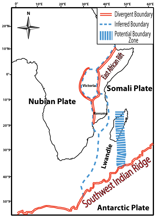
- Gradual separation of the Somali and Nubian tectonic plates is leading to the formation of a rift that could eventually lead to the creation of a new ocean basin.
- Arabian Plate has been gradually moving away from Africa, which has already led to the creation of the Red Sea and the Gulf of Aden.
- The crack was located at the intersection of three tectonic plates — the African Nubian, African Somali, and Arabian — that have been separating for some time.
- In 2018, a large crack emerged in the Kenyan Rift Valley, highlighting the ongoing process of rifting and its potential for creating a new ocean basin.
- It may take millions of years to fully form a new ocean, the potential creation of a new coastline and sub-continents has significant implications for the continent’s future.
Challenges & consequences
- As the plates continue to split in the future, this phenomenon will result in the displacement of communities, settlements and various flora and fauna. Nearly 15 million people will be internally displaced in Africa, according to the United Nations Environment Programme.
- Rapid urbanisation and increased settlements will put pressure on natural resources, leading to a scarcity of water, energy and food.
- Uncontrolled waste disposal will also be a significant concern. Furthermore, some species will disappear, while others will become endangered due to habitat changes.
- Rifts showcase a unique topography, distinguished by a chain of depressions bounded by faults and enclosed by elevated terrain.
- Separation of the Nubian and Somali plates can result in the formation of new faults, fissures and cracks or the reactivation of pre-existing faults, leading to seismic activity.
- Proximity of the hot molten asthenosphere to the surface causes volcanism, further displaying the ongoing process of continental breakup.
- Devastating weather patterns owing to global warming are altering landscapes and raising sea levels.
- Seafloor spreading will gradually advance along the entire extent of the rift lead to the flooding of the ocean, resulting in the African continent becoming a smaller, significant island composed of fragments of Ethiopia and Somalia, including the Horn of Africa.
Sun has developed a ‘coronal hole’ 20 times the size of Earth
Why in news ? Recently , a solar flare has caused a minor shortwave radio blackout over Indian Ocean
Background:
- A massive dark patch appeared in the southern stretches of the sun's outer atmosphere, also called the corona. Known as coronal holes, these features are much cooler than the surrounding atmosphere.
- Through these coronal holes, high-speed solar winds made of electrically charged particles and magnetic fields gush out into space; the current hole is releasing winds exceeding 1.3 million mph
- Earth has narrowly escaped the incoming wave of a coronal mass injection (CME) cloud and avoided a solar storm event.
- Things become worse when a newly formed sunspot exploded spewing out an M 3- class solar flare.
Zone of impact of flares :
- Usually these flares impact the Pacific Ocean and surrounding countries such as Australia, New Zealand , South American countries and Western coast of USA.
- The recent flare was Earth directed and the high radiation has affected the Indian Ocean region.
- South Asian countries including India, Sri Lanka, Bangladesh , China , Japan and South Korea have fallen into its geo effective area.
Effect of flares
- The flare eruption has caused a shortwave radio blackout in the region for a temporary period.
- During the flare , drone pilots , amateur radio operators and aviators would have faced temporary disruption for airline services and ships in the region.
- Eruption has released a CME cloud which will reach the earth in coming days and cause a solar storm event.
- Such solar storms can damage satellites , disrupt mobile network and internet services and in extreme cases can also damage power grids and Earth based sensitive electronics.
- Solar flares are categorised into B, C, M, and X types. While B class solar flares are minor ones, X class flares are the most potent ones.
Coral breach in Gulf of Mannar
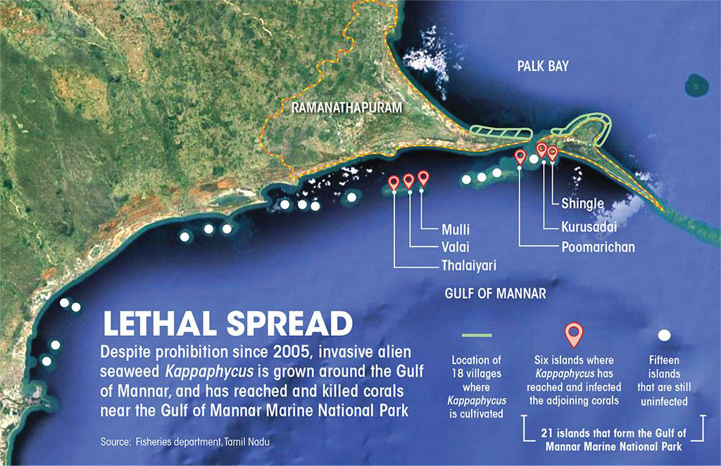
Why in news ? The dead coral reefs were observed near Kurusadai (Tamil Nadu), one of the 21 uninhabited islands forming the Gulf of Mannar Marine National Park.
Background:
- The massive and branching coral colonies in the Gulf of Mannar region are dying due to cultivation of an exotic invasive seaweed species identified asKappaphycus alvarezii ( algae)
- Shingle, Krusadai and Poomarichan islands, observed the bio-invasion of the seaweed, which has spread over one square km in the region.
Impact of sea weed
- Cultivation of the sea alien seaweed reduced penetration of sunlight into the coral colonies, which was very essential for their health and growth.
- The algae was firmly attached to the coral colonies and started forming mat over them, eventually smother and kill corals.
- It led to stunted growth of reefs with less shoot density, turbid environment and less fish catch.
- Macrofaunal and fish density decreased when Kappaphycus cover increased.
Seaweed utility
- Kappaphycushas the potential to improve livelihoods, profits to the native farmers and used in food, cosmetics, and medicines.
- It’s cultivation reduce India’s import of kappa-carrageenan, a polysaccharide extracted from the alga that finds use in industrial gums and as a smoothening agent in ice cream, toothpaste, jellies, medicines and paint.
- In the meat industry, it is used to ensure that meat retains its tenderness while transporting or exporting.
- It is source of nutrition, containing anti-inflammatory and anti-microbial agents.
- Acting as a bioindicator by absorbing excess nutrients and balancing out ecosystems.
- Mitigates climate change by sequestering carbon dioxide termed as ocean afforestation.
- If livestock is fed with seaweed, methane emission from cattle may be reduced substantially.
- Used as fertilizers to increase fish production.
- Buried in beach dunes to combat beach erosion.
Threats:
- IUCN has described the Kappaphycus as “destructive invasive species.
- Cannot promote its commercial cultivation in ecologically sensitive areas.
- Threat to Dugong population, since seagrass beds, which are their prime foraging grounds, are likely to be impacted.
Kappaphycus Production in India
- In 2021, India cultivated around 34,000 tonnes of seaweed, and the Centre earmarked Rs 600 crore to increase seaweed production to 11.85 million tonnes by 2025.
- Currently, about 750 farmers are engaged in seaweed farming, primarily Kappaphycus, in 18 villages of Ramanathapuram, Tamil Nadu and it is also likely to be cultivated in Tamil Nadu’s proposed seaweed park.
Measures undertaken
- Order was issued restricting the cultivation of the exotic species only to the seawaters north of the Palk Bay and south of Thoothukudi coast.
- Forest department carrying out manual removal of the seaweed to protect the coral reefs.
Intra cloud lightning
Intra-cloud lightning occurs when there are positive and negative charges within the same cloud. It causes various portions of the same cloud to light up. Sheet and heat lightning are common types of intra-cloud lightning. Recently few States have demanded that “ lightning “ be declared as a “ natural disaster “because deaths caused by it surpass any other disaster in India.
Lotic ecosystem
It is characterised by flowing waters. Examples include rivers , streams , brooks and springs. Here, the oxygen level is higher due to the continually moving waters of the current and the water is clearer. The flow of the water is different depending on the area of a river or stream. Recently government has decided to assess the rivers and streams of Northern Plains of India.
Maladaptation
It is a process that results in increased vulnerability to climate variability and change, directly or indirectly, and/or significantly undermines capacities or opportunities for present and future adaptation. According to Synthesis report of IPCC , there is an increased evidence of maladaptation in India in various sectors and regions. For example, mangrove plantation in coastal Odisha has disturbed the local ecosystems, affecting marginalised and vulnerable groups adversely.
Carbon offset
A carbon offset is a reduction or removal of emissions of carbon dioxide or other greenhouse gases made in order to compensate for emissions made elsewhere. A carbon offset credit is a transferrable instrument certified by governments or independent certification bodies to represent an emission reduction of one metric tonne of CO2, or an equivalent amount of other GHGs. Recently, it was revealed that forest carbon offsets approved by the world’s leading certifier Shell & other big corporations are largely worthless and could make global heating worse.
Moon Dust
The Moon’s dust is made up of ultra-tiny grains — formed by millions of years of meteorite impacts that repeatedly crushed and melted rocks, creating tiny shards of glass and mineral fragments. Not only can they travel at hurricane-like speeds, but they also cling to all types of surfaces, not only because of their jagged edges, but also because of their electrostatic charge. Recently, a team of researchers have published a study proposing that launching Moon Dust into the stratosphere can slow down global warming.
Horticulture hub in the Khasi hills of Meghalaya
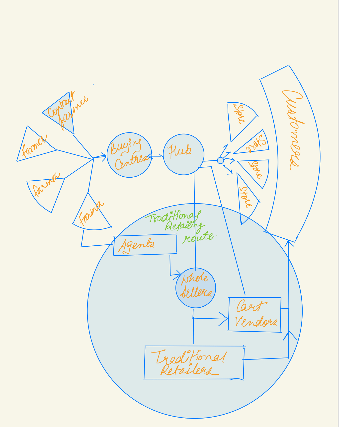
- Setting up horticulture hubs following the hub and spoke model under the Technology Mission for Integrated Development of Horticulture in Meghalaya.
- “ Horti Hubs” are created in each district of the State, which will function on a hub and spoke model within an area of 10-15 Kms radius & will create horticulture clusters having the potential of taking off horticulture in the State on a bigger scale.
- Wide, range of tropical, sub- tropical and temperate fruits such as Mandarin, Orange, Pineapple, Banana, Lemon, Guava, Pear, Plum etc. are grown all over the State.
- Use of Green house technology, poly-houses, drip and micro irrigation system, water harvesting structures, fertigation, soilless culture are being popularised to standardise quality of produce and reduce economic losses.
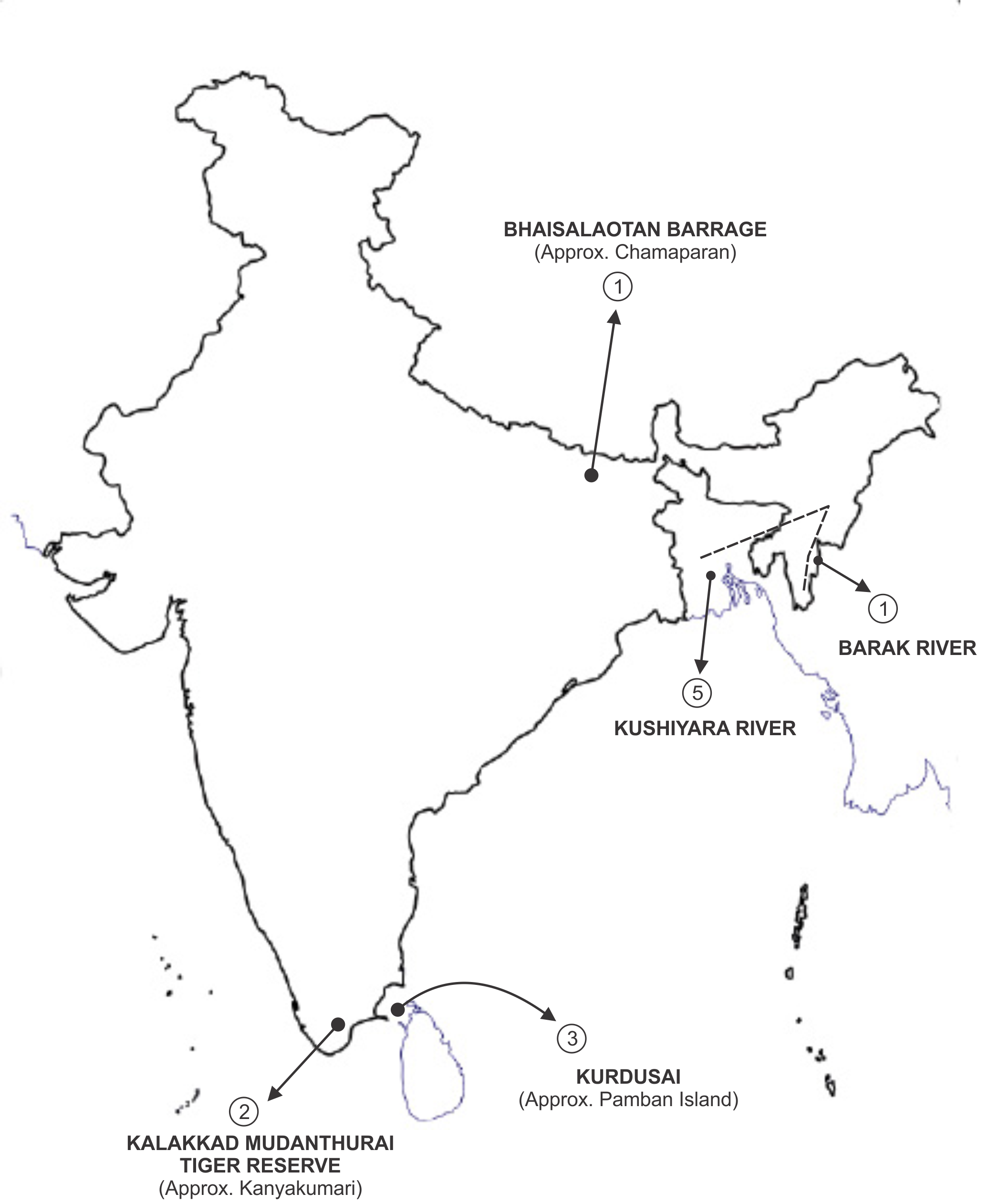
Map
|
1. |
Barak river: |
It rises in the Manipur hills and enters the plains near Lakhipur, Assam. The river enters Bangladesh as Surma and Kushiyara. Later, the river is called the Meghna and receives the combined flow of the Ganga and Brahmaputra. Recently depth dredging work of river Barak has been awarded to Dredging Corporation of India. |
|
2. |
Kalakkad Mudanthurai Tiger Reserve: |
The Kalakad Mundanthurai Tiger Reserve (KMTR) lies in Tirunelveli and Kanyakumari District of Tamil Nadu is one of the protected areas having diverse flora and fauna. It was declared as the “First Tiger Reserve of Tamil Nadu” and the 17th Tiger Reserve of the country. It consists of the Kanyakumari Wildlife sanctuary in the south and the Nellai Wildlife Sanctuary in the North. Recently, two researchers from Tamil Nadu have spotted a rare moth species for the first time in India in the buffer zone of Kalakkad–Mundanthurai Tiger Reserve. |
|
3. |
Kurdusai: |
It is an uninhabited island in the Gulf of Mannar situated south of Pamban Island. The island belongs to India and forms a part of the Gulf of Mannar Marine National Park, best known for its unique coral reefs. Recently, the dead coral reefs were observed near Kurusadai (Tamil Nadu). |
|
4. |
Bhaisalaotan barrage: |
It lies in the Valmikinagar of West Champaran district of Bihar. It is a famous tourist spot where a dam is built on the river Gandak (Gandak Project) for the purpose of irrigation. Recently, under Namami Gange Program, the development of river front on Gandak River in this region has been undertaken . |
|
5. |
Kushiyara river: |
The Kushiyara River is a distributary river in Bangladesh and Assam . It forms on the India-Bangladesh border as a branch of the Barak River when the Barak separates into the Kushiyara and Surma. The waters of the Kushiyara originate in the state of Nagaland and pick up tributaries from Manipur, Mizoram and Assam. Withdrawal of waters from Kushiyara has been the bone of contention between India and Bangladesh. |
KOSMOS MCQs
Q1. Consider the following:
Glacier : Place
- Pensilungpa Glacier : Eastern Himalayas
- Durung-Drung Glacier : Pithoragarh
- Milam Glacier : Ladakh
Which of the above mentioned pairs are correctly matched?
- Only one pair is correct
- Only two pairs are correct
- Only three pairs are correct
- None of the pair is correct
Q2. With reference to Coordinated Universal Time, consider the following statements:
- It is the primary time standard by which world regulates clocks and time.
- It is effectively a successor to Greenwich Meridian Time (GMT).
Which of the above mentioned statements is/ are correct?
- Only 1
- Only 2
- Both 1 and 2
- Neither 1 nor 2
Q3. Consider the following statements regarding recently launched Landslide Atlas of India:
- The Landslide Atlas of India was released at International Conference on Disaster held in New Delhi.
- The Atlas was prepared by the Geological Survey of India.
- Mizoram recorded the highest number of landslide events in the past 25 years.
Which of the above mentioned statements is/ are correct?
- Only 1 and 2
- Only 2
- Only 3
- Only 2 and 3
Q4. With reference to Forest fires, consider the following statements:
- Underground forest fires are of low intensity, consuming the organic matter beneath the surface
- The Forest Fire Prevention and Management Scheme (FPM) is the only government-sponsored programme dedicated to assisting states in dealing with forest fires.
- Wildfires occur in all the continent over earth surface.
Which of the above mentioned statements is/are correct?
- Only 1 and 2
- Only 2 and 3
- Only 1 and 3
- All of the above
Q5. Consider the following statements regarding Lightning:
- Intercloud or intra cloud lightning is harmful and lead to electrocution .
- Lightning strikes the tropical areas more than other areas.
- Lightning is not classified as a natural disaster in India.
Which of the above mentioned statements is/are correct ?
- Only 1 and 2
- Only 2 and 3
- Only 1 and 3
- All of the above
Q6. Consider the following statements regarding recently erupted Mount Merapi volcano :
- It is a volcano located on its homonymous island in the South of the Tyrrhenian Sea.
- It is a active strato volcano designated as “One of the Decade Volcanoes”.
Which of the above mentioned statements is/ are correct?
- Only 1
- Only 2
- Both 1 and 2
- Neither 1 nor 2
Q7. With reference to recently constituted Committee to Oversee Transfer/Import of Wild Animals in India, consider the following:
- The committee was constituted under the Chairmanship of Salim Ali , also known as the “ Birdman of India “
- The ambit of the committee is restricted to Tripura and Gujarat.
- All State and Central authorities shall report the seizure of wild animals or abandonment of captive wild animals to the Committee.
Which of the above mentioned statements is/ are correct?
- Only 1 and 2
- Only 2
- Only 3
- Only 1 and 3
Q8. Consider the following statements regarding Kalakkad–Mundanthurai Tiger Reserve (KMTR):
- It is located at the tri-junction of three states, viz, Karnataka, Kerala and Tamil Nadu.
- Nearly 13 rivers originate from KMTR, hence is known as River Sanctuary.
- The Reserve has tall grasses, commonly referred to as ‘Elephant Grass’.
Which of the above mentioned statements is/ are incorrect?
- 1 only
- 2 and 3 only
- 1 and 3 only
- 1 ,2 and 3
Q9. Consider the following statements regarding World Air Quality Report 2021:
- The report measures air quality levels only on the basis of concentration of Particulate Matter (PM) 2.5.
- Not a single country in the world managed to meet the WHO’s air quality standard in 2021.
Which of the above mentioned statements is/ are correct?
- Only 1
- Only 2
- Both 1 and 2
- Neither 1 nor 2
Q10. Recently the first census on vultures was carried out by Kerala Forest department. Which among the following is incorrect about the vultures?
- Vomiting serves as a defense mechanism for them to deter predators.
- Vultures build their nest only after mating to lay their eggs
- Apart from poisoning , car collision is one of the biggest threat to vultures.
- Vultures are often seen with other carrion-eating animals.
Q11. Consider the following:
Passes : Places
- Razdan Pass : Connects the Kinnaur and Tibet
- Zojila Pass : Connects Indus Valley to Suru Valley
- Burzail pass : Connects Gurez valley to Kashmir valley
Which of the above mentioned statements is/ are correct?
- Only 1
- Only 2
- Only 1 and 3
- Only 2 and 3
Q12. Consider the following statements regarding Horseshoe crab:
- The crab was in the Schedule IV of the Wild (Life) Protection Act, 1972, under which, the catching and killing of a horseshoe crab is an offence.
- The blood of Horseshoe crab is very important for preparation of rapid diagnostic reagent.
Which of the above mentioned statements is/ are correct?
- Only 1
- Only 2
- Both 1 and 2
- Neither 1and 2
Q13. Recently, the dead coral reefs were observed near Kurusadai (Tamil Nadu), one of the 21 uninhabited islands forming the Gulf of Mannar Marine National Park. Which among the following was the primary reason for this loss?
- It is caused by heat stress during La Niña conditions, which historically produces cooler summer conditions at the reef.
- It is caused by strong storms, which has broken coral branches and overturn coral colonies.
- It is caused by marine debris, also known as human trash, killing coral reefs and the many animals that live in them.
- It is caused by seaweed species deliberately introduced for commercial cultivation some two decades ago.
Q14. A particular state in India has the following characteristics:
- It is located on the same latitude which passes through northern Rajasthan.
- It has over 80% of its area under forest cover
- Over 12% of forest cover constitutes the Protected Area Network in this state.
Which one among the following states has all the above characteristics?
- Arunachal Pradesh
- Assam
- Tripura
- Manipur
Q15. Consider the following statements regarding Gandak river:
- The river flows through the Indian states of Bihar and Uttar Pradesh, and joins the Ganges near Patna.
- Trisuli and Panchand are the major tributaries of the Gandak River.
- River Gandak was declared as National Waterway in the country .
Which of the above mentioned statements is/ are correct?
- 1 and 2
- 2 and 3
- 1 and 3
- All of the above
Share the article
Get Latest Updates on Offers, Event dates, and free Mentorship sessions.

Get in touch with our Expert Academic Counsellors 👋
FAQs
Geography Current Affairs focuses on the contemporary issues, events, and developments in the field of geography. It covers recent geographical phenomena, environmental changes, geopolitical shifts, and related news. This differs from regular geography studies which may focus more on foundational concepts, historical contexts, and theoretical frameworks.
Updates are provided regularly to ensure that subscribers stay informed about the latest developments in geography. Typically, updates are provided on a fortnightly basis, depending on the frequency of significant events and changes in the field.
Absolutely. Geography Current Affairs serves as a valuable resource not only for Geography optional but also for GS papers, especially GS Paper 1 (covering Indian Heritage and Culture, History, and Geography of the World and Society) and GS Paper 3 (covering Technology, Economic Development, Biodiversity, Environment, Security, and Disaster Management). It aids in building a holistic understanding of various topics and strengthens answer-writing skills by incorporating contemporary examples and perspectives.
Geography Current Affairs holds immense importance for UPSC preparation, particularly for aspirants opting for Geography optional. It helps candidates stay updated with the latest developments, geographical phenomena, environmental issues, and geopolitical shifts worldwide, aligning them with the dynamic nature of the subject as tested in the UPSC examinations.

