
10 Mar to 24 Mar, 2025
TRANSFORMATION IN URBAN LANDSCAPE
Why in news : Recently, Indian urban centres have been grappling with significant challenges such as water shortages, urban heating, and infrastructural strains amidst rapid urbanisation.
About :
According to the Asian Development Bank's 2019 report, the global urban population has surged from 751 million in 1950 (30% of the world's population) to 4.2 billion in 2018 (55% of the world's population).
Projections indicate that this figure will rise to 5.2 billion by 2030 (60% of the global population) and 6.7 billion by 2050 (68% of the global population).
India's urban population has grown steadily. According to the 2011 Census, urbanisation increased from 27.7% in 2001 to 31.1% in 2011, representing a total of 377.1 million people and an annual growth rate of 2.76%.
This trend has shifted focus from large Tier 1 cities (1,00,000 and above) to medium-sized towns, influenced by various push and pull factors such as employment, education, and security
Reasons of Urbanisation
- Trade And Industry: Trade and industry fuel urbanisation by creating jobs, boosting infrastructure, and fostering access to markets and innovation hubs. For example, cities like Mumbai and Bangalore thrive due to their industrial zones and IT parks, attracting skilled labor and investments.
- Economic Opportunities: Cities offer more diverse job opportunities than rural areas, hosting businesses, factories, and institutions. For instance, Delhi’s corporate hubs and Chennai’s manufacturing units provide employment to millions, drawing people from rural regions.
- Education: Urban areas boast superior educational institutions, attracting students and professionals. Cities like Pune and Hyderabad are renowned for their universities and research centers, enhancing career prospects for residents.
- Better Lifestyle: Cities provide advanced services like hospitals, libraries, and cultural venues, offering a vibrant lifestyle. For example, Kolkata’s cultural festivals and Delhi’s healthcare facilities make urban living more appealing than rural areas.
- Migration: Migration drives urbanisation, often leading to informal settlements due to high urban living costs. In cities like Mumbai, migrants settle in slums like Dharavi, lacking basic amenities such as clean water and sanitation, highlighting the challenges of rapid urban growth.

Key Challenges in Urbanisation
- Urban Inequality and Segregation: Indian cities showcase stark contrasts, with gated communities and SEZs coexisting alongside slums and informal settlements. Urban planning often prioritizes elite interests, leaving basic services inaccessible to many. Over 25% of urban populations live in poverty, with 81 million below the poverty line. Eg, Mumbai’s luxury towers contrast sharply with Dharavi’s slums, highlighting deep urban divides.
- Climate Vulnerability and Heat Stress: Indian cities are urban heat islands, with rising temperatures and poor climate resilience. Glass-facade buildings, shrinking green cover, and excessive AC use worsen heat stress. A 30% rise in heat stress over 40 years has been recorded, threatening 34 million jobs due to reduced productivity. Cities like Chennai and Mumbai struggle with flash floods and inadequate infrastructure for extreme weather.
- Inadequate Urban Governance and Institutional Fragmentation: Urban local bodies (ULBs) remain politically and financially weak despite the 74th Constitutional Amendment. Planning is outsourced, with minimal citizen engagement, and functions are fragmented, causing inefficiencies. Only 22.2% of ULB functions are fully developed, and intergovernmental transfers for cities are just 0.5% of GDP, as per CAG reports.
- Unsustainable Urban Mobility and Congestion: Indian cities are car-centric, with poor public transport and unsafe pedestrian infrastructure. Long commutes, averaging 1.5–2 hours daily in metros like Delhi and Bengaluru, harm productivity. While metro networks span 1,000 km across 17 cities, walkability and cycling infrastructure remain weak. The shift to electric mobility is slow and uneven.
- Informality in Employment and Housing: Urbanisation has not ensured secure jobs or housing. Over 90% of urban employment is informal, lacking benefits or protections. Housing remains unaffordable, pushing 236 million people into slums (UN-Habitat 2021). Post-Covid recovery is K-shaped, favoring formal sectors, while informal workers struggle.
- Environmental Degradation and Poor Urban Resilience: Urbanisation has led to vanishing green cover, wetland loss, and polluted water bodies. Construction-centric development causes flash floods, drainage failures, and air pollution. Thirteen Indian cities, including Delhi and Faridabad, rank among the world’s top 20 most polluted (IQAir).
- Weak Mayoral Leadership and Political Disempowerment: Indian mayors have limited powers, often overshadowed by state-appointed Municipal Commissioners. Unlike global cities where mayors drive urban policy, Indian urban governance remains top-down and bureaucratic, undermining local democracy. For example, Bengaluru’s mayor lacks executive authority, hindering effective decision-making.
.jpeg")
International Initiatives for Urban Development
- 15-Minute City (Paris, France) : An urban model ensuring residents can access work, education, healthcare, and recreation within a 15-minute walk or bike ride. It can inspire zonal planning, mixed-use development, and last-mile connectivity improvements in cities like Delhi and Bengaluru.
- Transit-Oriented Development (Tokyo, Japan) : Integrates high-density housing, commercial spaces, and public services around mass transit hubs. It aligns with India’s Metro Rail Policy, helping reduce congestion and pollution in cities.
- Green Infrastructure & Sponge Cities (China) : Urban designs that absorb rainwater using wetlands, green roofs, and permeable surfaces. Cities like Mumbai and Chennai can adopt this to tackle urban flooding and improve water management.
- Integrated Digital Urban Governance (Tallinn, Estonia) E-governance platforms that consolidate city services—property, permits, utilities—into a single digital interface.
It is also scalable under the Smart Cities Mission and Urban Digital Public Infrastructure (DPI) initiatives. - Vertical Greening and Bioclimatic Architecture (Singapore) : Use of vertical gardens, green roofs, and climate-responsive building designs. It also promotes sustainable architecture, moving away from energy-intensive glass façades to passive cooling solutions.
GOI Initiatives for Urbanisation
- Smart Cities : To promote cities that provide core infrastructure and give a decent quality of life to its citizens, a clean and sustainable environment and application of Smart Solutions.
- AMRUT Mission : Capacity building, reform implementation, water supply, sewerage and septage management, storm water drainage, urban transport and development of green spaces and parks.
- Swachh Bharat Mission : Achieved its target of creating Urban India Open Defecation Free (ODF).
- PM Awas Yojana -Urban : To achieve the objective of “Housing for All” by 2022, the erstwhile rural housing scheme Indira Awaas Yojana (IAY) was restructured to Pradhan Mantri Awaas Yojana-Gramin (PMAY-G) w.e.f 1st April, 2016.
- National Urban Livelihood mission : It aims to uplift urban poor by enhancing sustainable livelihood opportunities through skill development.
Way forward
- Adopt a Place-Based, Tiered Urban Governance Model : Indian cities must move beyond uniform frameworks to adopt tiered governance tailored to metropolitan, mid-sized, and small towns. Example: Mumbai Metropolitan Region Development Authority (MMRDA) demonstrates integrated planning for a megacity.
- Shift from Car-Centric to Human-Centric Urban Mobility : Cities must prioritise public transport, walkability, and cycling to cut emissions and enhance accessibility. Example: Delhi Metro’s integration with feeder buses and cycle-sharing systems.
- Decongest Urban Landscapes : Strengthen rural infrastructure to reduce urban migration pressure.Example: Gujarat’s GIFT City as a counter-magnet to Mumbai.
- Reorient Building Codes Toward Climate-Responsive Architecture : Revise the National Building Code to enforce climate-sensitive designs using passive cooling, natural ventilation, and local materials. Eg. Chennai’s ITC Green Centre, a GRIHA-certified building with energy-efficient design.
- Mainstream Urban Blue-Green Infrastructure for Climate Resilience : Restore and integrate water bodies, wetlands, and green corridors into urban planning. Example: Ahmedabad’s Sabarmati Riverfront and urban lake revival projects.
- Enable Data-Driven, Interoperable Urban Platforms : Invest in urban digital public infrastructure (DPI) for real-time monitoring and planning. Example: Surat’s ICCC for real-time traffic and utility management.
Conclusion
India's urban transformation must transcend fragmented governance and elite-focused planning, shifting toward inclusive, climate-resilient, and people-centric cities. Aligning urban development with SDG 11 (Sustainable Cities and Communities) is essential to fostering livability, resilience, and equitable resource access. Only through such an approach can Indian cities transition from enduring "two-hour commutes" to becoming vibrant, sustainable ecosystems that benefit everyone.
Where to use :
Paper I ( Settlement Geography ) : Urbanisation and its problems
Source :
https://www.openpr.com/news/3887049/transforming-urban-landscapes-the-evolving-smart-cities
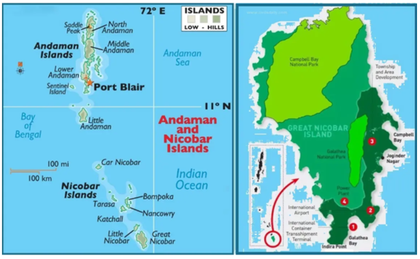
GREAT NICOBAR PROJECT
Why in news : The proposed Rs 80,000 crore mega infrastructure project on Great Nicobar Island (GNI) has raised serious concerns among environmental activists.
About :
The Great Nicobar Project
The Great Nicobar Project is a massive infrastructure initiative worth ₹72,000 crore, aimed at transforming Great Nicobar Island. It is being executed by the Andaman and Nicobar Islands Integrated Development Corporation (ANIIDCO).
The project spans 16,610 hectares and seeks to capitalize on the island’s strategic location near the Malacca Strait. Key components of the Great Nicobar Island Development Project include:
- An International Container Transshipment Terminal (ICTT)
- A greenfield international airport
- Development of two greenfield cities
- A coastal mass rapid transport system
- A free trade zone
- An international cruise terminal (new addition)
- A shipbreaking yard (new addition)
Geography of Great Nicobar Island
Great Nicobar Island is the southernmost point of India, part of the Andaman and Nicobar archipelago, which consists of over 600 islands. The island is characterized by hilly terrain and dense rainforests, receiving approximately 3,500 mm of annual rainfall.
Its rich ecosystems support numerous endangered and endemic species, such as the giant leatherback turtle, Nicobar megapode, Great Nicobar crake, Nicobar crab-eating macaque, and Nicobar tree shrew. The island covers 910 sq km, with mangroves and Pandan forests lining its coastline.
This project aims to balance strategic development with the preservation of the island’s unique biodiversity and ecological significance.
Significance of the Great Nicobar Island Development Project
- Geo-Strategic Benefit : Located near the Malacca Strait, a key global trade route, the project enhances India’s role in the regional and global maritime economy.
- Geo-Security Concerns : Strengthens India’s maritime security in the Bay of Bengal and Indian Ocean, countering Chinese naval expansion and bolstering deterrence capabilities.
- Upgradation of Military Infrastructure : Develops airfields, jetties, and surveillance facilities, enhancing India’s defense preparedness.
- Economic Boost : The International Container Transshipment Terminal (ICTT) positions Great Nicobar as a major cargo transshipment hub, boosting regional economic activity.
- Job Creation for Locals : Infrastructure development (ports, airports, etc.) generates employment opportunities for the local population.
Associated Concerns with the Great Nicobar Project
- Threat to Biodiversity : Nearly 1 million trees may be felled, devastating the island’s ecosystem, including coral reefs, the Nicobar Megapode bird, and leatherback turtles. Compensatory afforestation in Haryana is inadequate.
- Threat to Indigenous Tribes : The project endangers the Shompen and Nicobarese tribes, violating the Forest Rights Act (2006), which grants the Shompen sole authority over the tribal reserve.
- Seismic Vulnerability : The proposed port lies in a seismically volatile zone, with risks highlighted by the 15-foot subsidence during the 2004 tsunami, raising safety and viability concerns.
- Lack of Adequate Consultation : The project bypassed meaningful stakeholder consultations, including the Tribal Council, and the NGT committee’s report on environmental clearances remains undisclosed.
- Undermining International Obligations : The Galathea Bay Wildlife Sanctuary, part of a UNESCO World Heritage Site, must be preserved as per India’s international commitments.
- Inadequate Social Impact Assessment : Concerns from Campbell Bay panchayat highlight insufficient assessment of social impacts, such as increased disease risks for the Shompen tribe due to outsider contact.
Conclusion
India must strive to realize its vision of “Happy and Prosperous Islanders on Ecologically-Protected Islands.” Achieving this requires development plans that are technically feasible, economically viable, and socially inclusive, ensuring a balance between progress and sustainability.
Where to use :
Paper I ( Geography Optional ) : Regional Planning
Paper II ( Geography Optional ) : Island development and Backward area development
Paper III ( General Studies ) : Environment Conservation
Source :
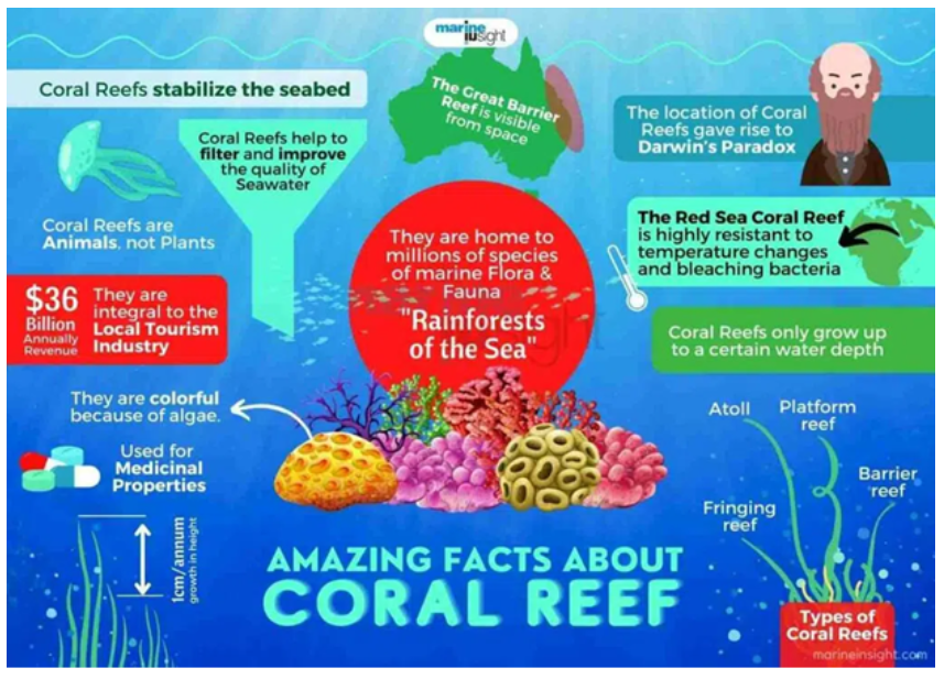
WORLD’S LARGEST DEEP SEA CORAL REEF MAPPED
Why in news : The reef is around 310 miles (500 km) long, extending from Florida to South Carolina. In some places, it is as wide as 68 miles (110 km).
About :
The newly found reef, spanning from Florida to South Carolina, is a significant underwater structure with a range of notable features:
Features of Newly Found Reef
- Vast Size and Extent: The reef's length is approximately 500 km, and at certain points, it can be as wide as 110 km. Its vast area makes it almost three times larger than Yellowstone National Park, highlighting its immense scale.
- Depth and Light Conditions: The reef is found at depths ranging from 200 to 1,000 meters.
- This depth range places it in regions beyond the penetration of sunlight, categorizing it as a deep-sea environment.
- This aspect is crucial because it suggests that the ecological dynamics, including the types of species and the biological processes in this reef, are likely to be significantly different from those in shallow-water reefs.
- Comparison with Other Reefs: While this newly found reef is significant for being one of the largest in deep water, it contrasts with the Great Barrier Reef, known as the largest coral reef system in shallow waters.
- The distinction between deep-water and shallow-water reef systems is crucial from an ecological and biological perspective, as the two environments offer vastly different conditions for marine life, influencing factors like light availability, water pressure, and the types of organisms that can thrive.
- Potential for Further Discoveries: A scientist's mention of the possibility of discovering even larger deep-sea reefs in the future is intriguing. This statement is supported by the fact that only about 25% of the world's ocean floor has been thoroughly mapped with high resolution.
- The vast unexplored areas of the ocean floor hold the potential for numerous other significant discoveries, which could offer more insights into marine biodiversity, geological structures, and potentially unknown biological and ecological processes.
Difference Between Deep and Shallow Water Coral Reef
|
SPECIFICATIONS |
SHALLOW WATER |
DEEP WATER |
|
Appearance |
Brown & Green |
White |
|
Diversity |
High |
Low |
|
Food |
Rely on Photosynthetic algae |
Feed on small plankton or available organic material |
|
Habitats |
Provides to sponges, crabs , etc |
Provides to sharks, swordfish , Octopus etc |
|
Type of Structure |
Rock Life |
Groves in the form of feathers, trees , etc |
|
Growth process |
Require Sunlight |
Dont require Sunlight |
|
Distribution |
Less coverage of ocean floor |
Larger coverage of ocean floor |
|
Challenges |
Climate change , Disturbance from oil and gas drilling . |
Climate change , Disturbance from oil and gas drilling |
Where to use :
Paper I ( Geography Optional ) : Coral reefs
Paper II ( Geography optional ) : Biodiversity
Paper III (General Studies ): Environment and wildlife, flora and fauna.
Source :
Mycelium bricks
Mycelium bricks : Mycelium bricks are sustainable building materials made from the root structure of fungi, bound together using organic waste. They are lightweight, biodegradable, and have good insulation properties. These bricks can replace conventional bricks, reducing environmental impact. Their production requires less energy and emits fewer greenhouse gases.
Water circularity
Water circularity : Water circularity involves reusing, recycling, and treating water efficiently to minimize waste and promote sustainable water management. It emphasizes closing the water loop by treating wastewater for non-potable or potable reuse, reducing freshwater extraction, and improving resource efficiency.
Pneumatophores
Pneumatophores : Pneumatophores are specialized aerial roots found in mangroves and swamp plants that protrude above waterlogged soil to facilitate oxygen intake in anaerobic conditions. They enable plants like Avicennia and Rhizophora to survive in saline environments by ensuring adequate respiration.
Globally Important Agricultural Heritage
Globally Important Agricultural Heritage systems : These are outstanding landscapes of aesthetic beauty that combine agricultural biodiversity, resilient ecosystems and a valuable cultural heritage. Located in specific sites around the world, they sustainably provide multiple goods and services, food and livelihood security for millions of small-scale farmers
Anadromous - 24 March 2025
Anadromous : Anadromous is a life cycle where fish live most of their life in saltwater but return to where they hatched to spawn in freshwater. Less than 1% of the world's fish population is diadromous. Anadromous fish make up around 75% of the diadromous population, while the remaining 25% are catadromous.
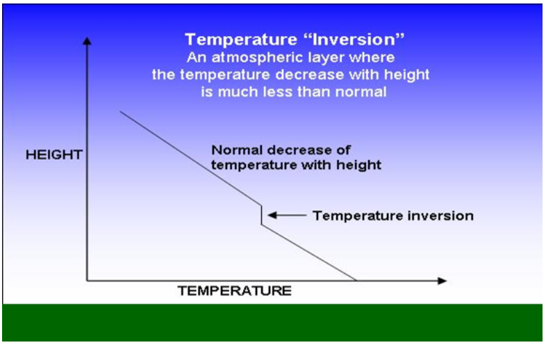
Temperature inversion predominantly occurs during winter
- Temperature inversion predominantly occurs during winter, particularly at night and in the early morning.
- Atmospheric stability forms a barrier that impedes the dispersion of PM 2.5 particles, consequently deteriorating the Air Quality Index. This phenomenon results in the formation of a pollution dome.
Where to use :
Paper I ( Geography Optional ) : Temperature Inversion and Pollution dome
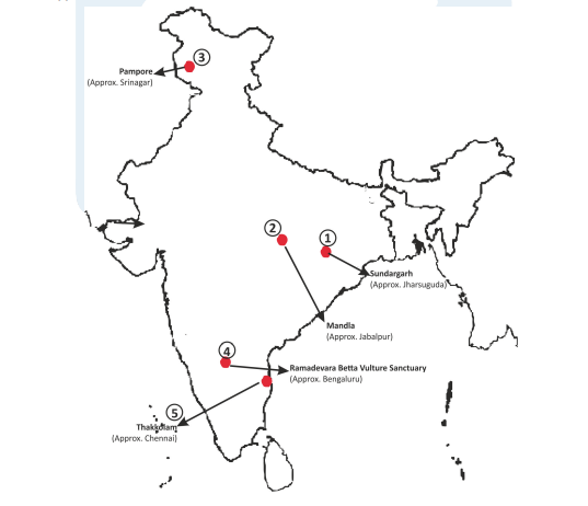
Places in News - 24 March 2025
1. Sundargarh
Why in news : NGT takes note of 11 units in Sundargarh for flouting norms.
- It is recognized as an industrial district in Odisha.
- It occupies a prominent position in the mineral map of Odisha and is rich in iron ore, limestone, and manganese.
- The Ib river flows in the northern part of the district.
- The climate of this district is characterized by extremely hot summers and cool winters. The climate is hot and moist sub-humid. The normal rainfall of the district is approximately 1230 mm.
- Approx. Jharsuguda
2. Mandla
Why in news: In Amjhar village of Mandla district in Madhya Pradesh, residents regularly remove lantana saplings from the common land that was cleared of the weed in 2024.
- It is a district of Madhya Pradesh in central India and is part of Jabalpur Division.
- It is one of the 24 districts in Madhya Pradesh currently receiving funds from the Backward Regions Grant Fund Programme (BRGF).
- Much of the district is forested, and it is home to Kanha National Park, a Project Tiger sanctuary
- The district is also home to Mandla Plant Fossils National Park.
- Approx. Jabalpur.
3. Pampore
Why in news : Recently there has been decline in the production of Saffron in Pampore region of Kashmir.
- Pampore is a town in Jammu and Kashmir, India, known for its saffron fields.
- It's located on the eastern side of the Jhelum River, about 14 km south of Srinagar.
- Pampore is known as the "Saffron Capital of India".
- It is also known as Pampar or Panpar in Kashmiri
- Approx : Srinagar
4. Ramadevara Betta Vulture Sanctuary
Why in news : Rare long-billed vultures have been breeding at Ramadevara Betta WLS for the fourth consecutive year marking a significant conservation success story .
- It is situated in the Ramadevara Betta Hill Range in Ramanagara, Karnataka.
- It is India’s first and only vulture sanctuary established in 2012 and notified Eco-Sensitive Zones (ESZ) in 2017 to safeguard endangered vulture species.
- The Sanctuary is home to three of the nine vulture species found in India — the Indian Long-Billed Vulture, Egyptian Vulture (Neophron percnopterus), and White-Backed Vulture (Gyps bengalensis).
- Approx : Bengaluru
5. Thakkolam
Why in news : The Jalanatheswarar temple at Thakkolam in Ranipet district, Tamil Nadu is in a deteriorating state.
- It is a panchayat town in Ranipet district of Tamil Nadu.
- The place has got a very famous god called Lord Dhakshinamoorthy in "Thava kolam" since ever called thakolam.
- Approx : Chennai
Fortnightly KOSMOS MCQs Practice - 24th March 2025
Q1. Consider the following statements regarding the Beijing Declaration and Platform for Action (BPfA), 1995:
1. It was adopted during the 4th World Conference on Women, which took place in New York, USA.
2. The Beijing+30 Action Agenda seeks to review and evaluate the progress made in implementing the BPfA after 30 years.
Which of the statements given above is/are correct?
- 1 only
- 2 only
- Both 1 and 2
- Neither 1 nor 2
Q2. With reference to India’s energy sector, consider the following statements:
1. India ranks as the 3rd largest oil importer and consumer in the world.
2. India has set a target to double its oil and gas exploration area by 2030.
3. The Ethanol Blended Petrol (EBP) programme has contributed to reducing CO₂ emissions by over 500 lakh metric tons in India.
Which of the statements given above is/are correct?
- 1 and 2 only
- 2 and 3 only
- 1 and 3 only
- 1, 2, and 3
Q3. With reference to the geographical location of the North Sea, consider the following statements:
1. It is connected to the Atlantic Ocean via the Strait of Dover and the English Channel, and to the Baltic Sea through the Skagerrak and Kattegat.
2. It is bordered by the United Kingdom, Norway, Denmark, Germany, the Netherlands, Belgium, and France.
Which of the statements given above is/are correct?
- 1 only
- 2 only
- Both 1 and 2
- Neither 1 nor 2
Q4. Which of the following organizations published the World Air Quality Report in 2024?
- System of Air Quality and Weather Forecasting and Research (SAFAR)
- United Nations Environment Programme (UNEP)
- IQAir
- Central Pollution Control Board (CPCB)
Q5. Consider the following statements regarding mycelium bricks:
1. They are produced using fungal spores, husk, and sawdust, resulting in a lightweight fibrous structure.
2. Mycelium bricks release significantly more CO₂ during production compared to traditional fired clay bricks.
3. They are biodegradable, fire-resistant, and offer good thermal insulation.
Which of the statements given above is/are correct?
- 1 and 2 only
- 2 and 3 only
- 1 and 3 only
- 1, 2, and 3
Q6. With reference to the Carbon Credit Trading Scheme (CCTS), consider the following statements:
1. It was launched under the Energy Conservation (Amendment) Act, 2022, to create the Indian Carbon Market (ICM).
2. The scheme transitions the focus from energy efficiency to reducing the intensity of greenhouse gas (GHG) emissions.
3. It grants Energy Saving Certificates (ESCerts) to industries that surpass their emission reduction targets.
Which of the statements given above is/are correct?
- 1 and 2 only
- 2 and 3 only
- 1 and 3 only
- 1, 2, and 3
Q7. Consider the following statements:
1. India has acquired land in Zambia for copper and cobalt exploration, led by Geological Survey of India (GSI).
2. Zambia ranks as the largest producer of copper in the world.
3. The Geological Survey of India (GSI) is spearheading India’s exploration of lithium reserves in South America and Australia.
Which of the statements given above is/are correct?
- 1 only
- 2 and 3 only
- 1 and 3 only
- 1, 2, and 3
Q8. Consider the following statements related to National Board of Wildlife:
1. It was established under the Environment Protection Act, 1986.
2. The Prime Minister serves as its ex-officio chairperson.
3. It ensures that no tiger reserve is diverted for unsustainable use without its approval.
How many of the above statements is/are correct?
- Only one
- Only two
- All three
- None
Q9. Wallace Line, recently in the news, is related to which of the following?
- It is an imaginary boundary separating the distinct faunal regions of Asia and Australia.
- It is a longitudinal line dividing the Atlantic and Pacific Oceans
- It is a geopolitical boundary between Europe and Asia
- It is a tectonic fault line in the Indian Ocean
Q10. Consider the following statements:
1. India holds the 2nd largest textile manufacturing capacity in the world.
2. It is the largest producer of jute globally and the 2nd largest producer of man-made fibres (MMF).
3. In India, 100% Foreign Direct Investment (FDI) is permitted in the textile sector through the government route to attract foreign investment.
How many of the statements given above is/are correct?
- Only one
- Only two
- All three
- None
Share the article
Edukemy’s Current Affairs Quiz is published with multiple choice questions for UPSC exams
MCQ
Get Latest Updates on Offers, Event dates, and free Mentorship sessions.

Get in touch with our Expert Academic Counsellors 👋
FAQs
Geography Current Affairs focuses on the contemporary issues, events, and developments in the field of geography. It covers recent geographical phenomena, environmental changes, geopolitical shifts, and related news. This differs from regular geography studies which may focus more on foundational concepts, historical contexts, and theoretical frameworks.
Updates are provided regularly to ensure that subscribers stay informed about the latest developments in geography. Typically, updates are provided on a fortnightly basis, depending on the frequency of significant events and changes in the field.
Absolutely. Geography Current Affairs serves as a valuable resource not only for Geography optional but also for GS papers, especially GS Paper 1 (covering Indian Heritage and Culture, History, and Geography of the World and Society) and GS Paper 3 (covering Technology, Economic Development, Biodiversity, Environment, Security, and Disaster Management). It aids in building a holistic understanding of various topics and strengthens answer-writing skills by incorporating contemporary examples and perspectives.
Geography Current Affairs holds immense importance for UPSC preparation, particularly for aspirants opting for Geography optional. It helps candidates stay updated with the latest developments, geographical phenomena, environmental issues, and geopolitical shifts worldwide, aligning them with the dynamic nature of the subject as tested in the UPSC examinations.