10 May to 24 May, 2024
MINING AND THREAT TO ARAVALLI ECOSYSTEM
Why in news : Recently, the Supreme Court has stopped the issuance of new mining licenses and renewals for existing ones in the Aravalli ranges and hills based on a report by the Forest Survey of India (FSI).
About :
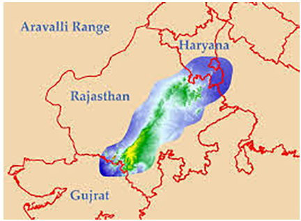
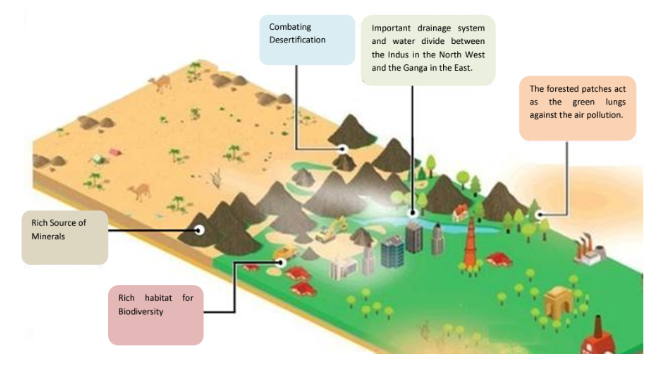
The Aravalli hills of India are the oldest mountain range on earth. Spread across four states in India, the Aravallis stretch from South West in Gujarat, Rajasthan to North East in Delhi and Haryana and play an important role in shaping the west-Indian climate and biodiversity.
Significance of Aravallis
- Geological formation : The range comprises ancient rock formations, including quartzite, schist, and marble, providing insights into the Earth's early crustal development.
- Climate regulation : They act as a barrier to the monsoon winds, impacting the climate of northwest India by regulating rainfall patterns.
- Watershed : Aravallis have provided a watershed between the Indus basin in the North West and the Ganga basin in the East.
- Water resources : The Aravallis are crucial for groundwater recharge and act as a watershed for numerous rivers, including the Banas, Luni, and Sahibi.
- Green Lungs : Its forested patches have acted as green lungs against the air pollution and soil erosion.
- Prevent degradation : These hills also moderated the wind velocity and checked the spread of the Indian Desert (Thar) towards eastern Rajasthan, Indo Gangetic plains, Haryana and Western UP.
- Mineral resources : It has also provided a rich habitat for wildlife and is a rich source of minerals like silica, quartz and other stones.
Major threat to Aravallis
- Mining : With growing urbanization and consequent increase in demand of building materials, mining operations in Aravallis are being carried out , violating all sorts of laws and guidelines.
- Deforestation : According to the Forest Survey of India (FSI) 2021 report, the degradation of forest land due to illegal activities is rampant, with approximately 31% of the Aravalli forests facing severe degradation
- Urban and Industrial expansion : According to Centre for Science and Environment , Delhi-NCR region has seen a 50% reduction in green cover over the past 20 years due to urban expansion.
- Water Resources : Increased instances of droughts and erratic monsoon patterns are being observed, impacting water resources and agriculture in Aravallis . Soil degradation affects approximately 60% of the land area in the Aravallis, leading to reduced agricultural productivity
- Loss of Biodiversity : According to the Biodiversity conservation report , 2019, the Aravalli region has lost over 30% of its floral diversity in the past two decades due to anthropogenic pressures.
- Invasive Species : According to Forest Research Institute, Invasive species cover approximately 15% of the forested areas in the Aravallis, outcompeting native plants
- Tourism Pressure : Unsustainable tourism practices have led to the degradation of popular sites like Mount Abu and Sariska Tiger Reserve.
Impact of Arvalli degradation on ecosystem
- Increased pollution and storms: Absence of adequate forest and degradation of hills, lead to frequent dust and sand storms in states like UP, Punjab, Delhi and may worsen the pollution levels in Delhi.
- Change in rainfall pattern : Data from Government of Rajasthan reveals that the duration of the rainy season has shrunk from 101 days in 1973 to only 46 days in 2010.
- Risk to public health : Due to crushing and mining of stones, the level of particulate matter increases. High level of particulate matter is attributed to increase in respiratory diseases such as chronic bronchitis and asthma cases. The number of cases and deaths due to Silicosis in the five districts of Alwar, Jaipur, Jodhpur, Kota and Udaipur has increased from 2015 to 2017.
- Drying up of lakes : Digging or mining to a great depth causing puncturing of aquifers, thus disturbing the water flow regimes. Lakes like the Soorajkund lake are drying up eventually.
- Popping up of new lakes : There are a number of such water bodies that have filled the depressions left by mine contractors. Eg Bhardwaj Lake in Faridabad.
|
CASE STUDY OF LAND USE CHANGE IN ARAVALLIS : FARIDABAD A study using remote sensing data was conducted to correlate land use changes and mining activities with surface water bodies in Faridabad district of Haryana and observe the changes over the 35 year period, 1970-2006. The study concludes that major changes were observed mostly in areas formerly occupied by vegetation, agriculture, and forest, which were converted into residential use. Between 1970 and 2006, urban areas increased to 310.8%. Mining area both legal and illegal increased to 587.9%. A decrease of 39.9% in water bodies has been observed. The excessive withdrawal of water due to mining activity resulted in shortage of surface water. It is further noticed that agricultural area reduced by 40.6% whereas there was rise in rural area by 444% compared to 1970s which is attributed to settlement of population from erstwhile village land. |
Supreme Courts order on Aravalis
- 1992: The Central government's approval became mandatory for all mining and industrial activities in the Aravalli region.
- 1996: Mining leases within a 2 km to 5 km radius of Badkhal Lake could not be renewed without the approval of both the central and state pollution control boards.
- 2002: Mining activities were banned in Haryana due to extensive degradation in Faridabad and surrounding areas.
- 2009: A ban on mining throughout the Aravalli range was re-imposed.
- 2018: The Supreme Court ordered the complete demolition of the Kant Enclave residential complex, spanning approximately 424.84 acres in the Aravalli forest range, and mandated the company to fully reimburse investors.
The Supreme Court's Ruling and Legal Notifications
- In 2018, Despite the Supreme Court's clear ban on real estate activities in the Aravalli range within Haryana, the state government not only approved these construction projects but also facilitated their execution.
- The Supreme Court established the "precautionary principle," which mandates that central and state governments must anticipate and prevent environmental degradation when considering projects
- On May 7, 1992, the Ministry of Environment, Forest and Climate Change (MoEFCC) issued "The Aravalli Notification," prohibiting new industries, mining, deforestation, and construction activities, including roads and transmission cables, without prior permission from the MoEFCC.
Initiatives for Restoring Aravallis Ecology
- The Great Green Wall of India : "The Great Green Wall of Aravalli" is an ambitious ecological initiative to create a 1,600 km long and 5 km wide green corridor along the Aravalli range, stretching from Gujarat to Delhi. This corridor will be connected to the Shivalik hill range, and aims to plant 1.35 billion native trees over the next decade to restore forest cover in the area. Modeled after the Great Green Wall of the Sahara in Africa, this project will serve as a buffer against pollution, which is attributed to industrial emissions (51%), vehicles (27%), crop burning (8%), and Diwali fireworks (5%)
- Northern Aravalli Leopard and Wildlife Corridor : The Sariska-Delhi leopard wildlife corridor, also known as the Northern Aravalli leopard wildlife corridor, is a crucial 200 km long biodiversity and wildlife corridor extending from the Sariska Tiger Reserve in Rajasthan to the Delhi Ridge. This corridor is a vital habitat for Indian leopards and jackals native to the Aravalli region.
- Southern Aravalli Leopard Wildlife Corridor : The Southern Aravalli leopard wildlife corridor spans from Sariska and Ranthambore to the Rann of Kutch National Park and Gir National Park in Gujarat.
Way Forward
- Improved Land Use Planning : Land use planning should be enhanced to ensure the sustainable utilization of the Aravalli range's resources. This includes designing strategies for efficient and effective land management.
- Conservation Efforts: Efforts should focus on preserving the biodiversity of the Aravalli range by establishing protected areas and implementing measures to mitigate human impact on the environment.
- Sustainable Development : Initiatives for sustainable development should be implemented to ensure the resources of the Aravalli range are used responsibly. This can include promoting eco-tourism and other sustainable practices.
- Education and Awareness : Increased education and awareness among local residents are essential to ensure they understand the importance of the Aravalli range and take steps to conserve and protect it.
- Research and Monitoring : Conducting research and monitoring activities in the region is crucial to understanding the impacts of human activities on the environment and identifying areas of concern. This information will guide future development in the region.
Source :
Where to use :
Paper II ( Geography optional ) : Indian Geography
Paper III ( General Studies ) ; Environmental Conservation
AURORA BOREALIS IN INDIA
Why in news : Recently, Auroras which are typically visible in high-latitude regions such as the North and South Poles, were observed worldwide, including in areas where they are uncommon.
About :
- Auroras are bright, glowing displays seen near the North Pole (Aurora Borealis) and the South Pole (Aurora Australis).
- These phenomena occur due to the interaction between charged solar particles and the Earth's magnetic field and atmosphere.
Composition and Color
- Auroras are made up of gasses and particles, such as oxygen and nitrogen.
- When these particles collide with the atmosphere, they release energy as light.
- The colors seen in auroras vary based on the type of gas and the altitude where the collisions occur.

Geomagnetic Storms and Auroras
- Geomagnetic storms, caused by solar events such as coronal mass ejections (CMEs) and solar flares, enhance auroral activity. CMEs are eruptions of plasma and magnetic fields from the Sun, while solar flares are bursts of energy.
- CMEs frequently occur in conjunction with solar flares, which are explosions on the Sun's surface, though they can also occur independently.
Solar Storms and Aurora Intensity
- Strong solar storms increase solar activity, leading to more pronounced auroral displays. The number of charged particles reaching the Earth's atmosphere during these storms intensifies the auroras.
- The strength of the solar storm and the alignment of the Earth's magnetic field influence the visibility and vibrancy of the auroras.
Cultural and Scientific Significance
- Auroras have cultural and spiritual importance in various indigenous communities worldwide. Inuit of North America view auroras as the spirits of ancestors playing in the sky, while the Sámi people of Scandinavia believe the lights hold spiritual messages.
- Scientific research on auroras aids in understanding the Earth's magnetosphere, solar-terrestrial interactions, and space weather.
Space Weather Research
- By studying them, scientists can better predict solar storms and other space weather events, which can affect satellite operations, GPS systems, power grids, and communication networks on Earth.
Navigation and Aviation
- For regions near the poles, auroras can affect magnetic navigation systems. Pilots and navigators need to account for auroral activity when planning routes and ensuring safety.
Tourism
- Auroras attract tourists from around the world, boosting local economies in regions where they are visible. "Aurora tourism" generates revenue for communities in the Arctic and Antarctic regions.
Impact of Auroras
- Radio Communications: High-frequency (HF) radio communications, often used for aviation and maritime navigation, can be disrupted during intense auroral activity.
- Geomagnetically Induced Currents (GICs): Geomagnetic storms can induce electric currents in power lines and pipelines, potentially damaging transformers and causing power outages. A notable example is the 1989 Quebec blackout caused by a severe geomagnetic storm.
- Atmospheric Chemistry: Geomagnetic storms can influence the composition of the upper atmosphere, affecting ozone levels and other atmospheric components.
Source :
Where to use :
Paper 1 ( General Studies ) : Important Geophysical phenomenon.
LAND SUBSIDENCE IN CHENAB VALLEY
Why in news : Recently minor land subsidence and frequent landslides were reported in various areas of the Chenab Valley.
About :
What is Land Subsidence ?
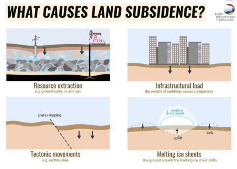
- Land subsidence refers to the sinking of the ground due to movement of underground materials, caused by various factors, both natural and human-induced.
Causes for Land Subsidence in Chenab Valley
- Unplanned Urbanization : Incidence of subsidence primarily to chaotic construction and unplanned urbanization in hilly regions.
- Unscientific Disposal of Waste water : Wastewater from residential and commercial establishments accumulates in the mountains, leading to land subsidence, which becomes more severe during rainfall.
- Improper drainage : It has been observed that absence of a proper drainage system was the primary reason for the land subsidence in the Nai Basti hamlet of Doda district.
- Infrastructure Projects : Large-scale development projects, such as the construction of tunnels, highways, and railways, have had an impact on the mountains surrounding the Ramban area, making them more susceptible to landslides and land subsidence. Eg. widening of NH-44 that connects New Delhi with Srinagar via Jammu and Udhampur-Srinagar-Baramulla Rail Link.
- Dumping in the river : Large amount of tunnelling and construction waste has been dumped into the Chenab river, disrupting the water flow, impacting the mountains. This disruption to the river's natural course could also contribute to land subsidence.
|
Other Causes of Land Subsidence
|
|
Some examples of Land Subsidence
|
Way Forward
- Environmental Preservation : Prioritize environmental conservation during Himalayan development by leveraging natural resources sustainably.
- Water Management : Implement efficient practices such as rainwater harvesting and recycling to reduce groundwater extraction.
- Monitoring Networks : Establish systems to track ground movements and seismic activity, providing early warnings of subsidence and earthquake hazards.
- Regulatory Measures : Enforce regulations on mining and resource extraction to prevent underground void formation.
- Climate Change Mitigation: Address climate change by reducing emissions and promoting sustainable practices to slow glacial melting and associated subsidence.
Source :
Where to use :
Paper 1 ( General Studies ) : Physical Geography , Important Geophysical Phenomena.
Hydroseeding
Hydroseeding : It is a widely used technique for controlling erosion and promoting vegetation growth on bare or disturbed soil surfaces. It involves a process where a mixture of seed, mulch, fertilizer, and water is sprayed onto the soil surface using specialized equipment.
Geomagnetic storms
Geomagnetic storms : It is a major disturbance of Earth's magnetosphere. These storms result from variations in the solar wind that produces significant changes in the currents, plasmas, and fields in Earth’s magnetosphere. The solar wind conditions that are effective for creating geomagnetic storms are sustained (for several hours) periods of the high-speed solar wind and a southward-directed solar wind magnetic field (opposite the direction of Earth’s field) at the dayside of the magnetosphere. The largest such storms are associated with solar coronal mass ejections (CMEs).
Soil nailing
Soil nailing: It is a construction technique that uses steel bars to stabilize and strengthen slopes, excavations, and retaining structures. It uses grouted, tension-resisting steel elements (nails) to reinforce in situ soils and create a gravity retaining wall for permanent or temporary excavation support.
Critical tiger habitat
Critical tiger habitat : These are core areas of tiger reserves and are identified under the Wild Life Protection Act (WLPA), 1972 based on scientific evidence. Such areas are required to be kept as inviolate for the purpose of tiger conservation, without affecting the rights of the Scheduled Tribes or such other forest dwellers. The notification of CTH is done by the state government in consultation with the expert committee constituted for the purpose.
Magnetic Flip
Magnetic Flip: A pole reversal, also known as a magnetic flip, occurs when Earth's magnetic north and south poles switch locations. This happens when iron molecules in the Earth's outer core start to move in the opposite direction to the iron molecules around them.
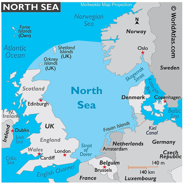
Marine Pollution in North Sea
Major causes for Marine pollution in North Sea are - Eutrophication , Plastic pollution , ocean mining , sewage and industrial toxins and offshore drilling. Ekofisk , an oil field was blown out in the year 1977, spilling 20, 2380 barrels of oil in North Sea. Industrial waste, Poly chlorinated biphenols dumped in river Rhine is discharged in North sea . Even run off from agri fields carries Nitrates and phosphates creating many marine dead zones in the North Sea. According to Global Plastic Outlook , 300 million tonnes of plastic is dumped in oceans annually , of which 50% is single use plastic.
Source :
https://www.researchgate.net/publication/255702521_Pollution_of_the_North_Sea_-_An_Assessment
Where to use :
Paper 1 ( Geography optional ) : Oceanography and marine pollution
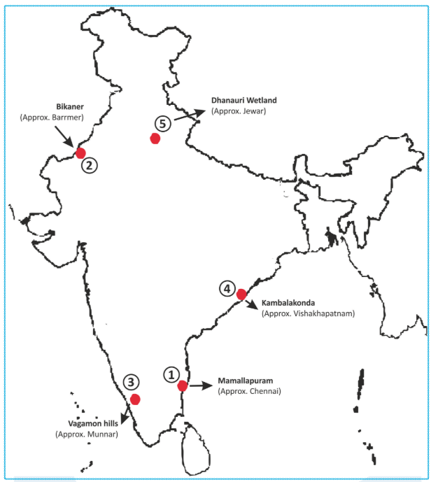
Places in the news
1. Mamallapuram
Why in news : 20-year New Town Development Plan has been prepared for the Mamallapuram New Town for the period 2025 to 2045
- Also called Mahabalipuram or Seven Pagodas, is a town that lies along the Coromandel Coast of the Bay of Bengal, 60 km south of Chennai.
- It contains many surviving 7th- and 8th-century Pallava temples and monuments, chief of which are the sculptured rock relief popularly known as “Arjuna’s Penance,” or “Descent of the Ganges.
- The town’s Five Rathas, or monolithic temples, are the remnants of seven temples, for which the town was known as Seven Pagodas. The entire assemblage collectively was designated a UNESCO World Heritage Site in 1984.
- Approx : Chennai
2. Bikaner
Why in news : In Rajasthan's Bikaner district, around 2 hectares of land has subsided.
- Bikaner District is a district of the state of Rajasthan in western India.
- The district is located in Bikaner Division along with the three other districts of Anupgarh, Sri Ganganagar and Hanumangarh.
- The Indira Gandhi Canal, also known as the Rajasthan Canal, runs through the district from northeast to southwest, providing irrigation water for the district.
- Approx : Barrmer
3. Vagamon hills
Why in news : The state government is moving forward with a proposal for developing a tourism township in either Vagamon or Munnar, facilitated by the UAE government.
- Vagamon is an enchanting hill station located on the Idukki-Kottayam border.
- The Vagamon Hills are classified into Thangal Hills, Kurishumala Hills and Murugan Hills. These three hills are meant for Muslims, Christians and Hindus, respectively.
- Approx : Munnar
4. Kambalakonda
Why in news : Envt authorities have given a facelift for the Kambalakonda wildlife sanctuary with new facilities.
- It is a forest located near Visakhapatnam, near Andhra Pradesh.
- The sanctuary is a tropical deciduous forest with a canopy of tree cover of mixed composition along with scrubland and meadows.
- It is bordered by Simhachalam hill range on the West and Gambheeram reservoir on the North-east.
- Approx : Vishakhapatnam
5. Dhanauri wetland
Why in news : Recently UP State Wetland Authority has written to the UP Ministry of Environment to clarify the position of the proponent department for declaring Dhanauri Wetland as a Ramsar site.
- The Dhanauri Wetlands is a bird-watching area located in Dhanauri village near Dankaur in Uttar Pradesh.
- It is home to over 120 Sarus cranes (Sarus Cranes is the state bird of Uttar Pradesh).
- It is a sanctuary for 23 species of endangered, critically endangered, and threatened birds, with special significance as a habitat for the majestic Sarus crane.
- Approx: Jewar
Fortnightly KOSMOS MCQs Practice
Q1. Consider the following statements regarding the Jiadhal river,
- The Jiadhal River flows through two Indian states, Sikkim and Assam.
- It is a northern sub-tributary of the Brahmaputra river and joins the Subansiri river.
- The Jiadhal River is known for its flash flood characteristics, exhibiting rapid, high volume discharges in short durations.
How many of the statements given above are correct?
- Only One
- Only Two
- All Three
- None
Q2. With reference to anticyclones, which of the following statements is not correct?
- Regions where air descends, leading to high pressure conditions, are termed anticyclones.
- Anticyclones lead to extended periods of stable and calm weather that can persist for several days or even weeks.
- Anticyclones frequently clear the way for depressions, which can lead to an increase in adverse weather conditions.
- Due to the rotation of the Earth, winds circulate clockwise around an anticyclone in the Northern Hemisphere and counterclockwise in the Southern Hemisphere.
Q3. Consider the following statements Unclassed forests:
- This forest is jointly owned by the government and private individuals or communities, and is also referred to as a deemed forest.
- Although the area is covered with forest-like vegetation, it has not been formally designated as a forest under the Indian Forest Act, 1980.
Which of the statements given above is/are not correct?
- 1 only
- 2 only
- Both 1 and 2
- Neither 1 nor 2
Q4. Consider the following statements about the Solar flares:
- A solar flare is a massive burst on the Sun, occurring when energy from twisted magnetic fields is suddenly released.
- These flares appear as luminous regions on the Sun and can persist for durations ranging from minutes to hours.
- Contrary to some beliefs, they do not impact radio communications, power grids, or navigation signals.
How many of the above statements are correct?
- Only one
- Only two
- All three
- None
Q5. Consider the following statements about the Bhimtal Lake:
- This lake holds the distinction of being the largest in Himachal Pradesh.
- The lake is natural, with its formation linked to multiple faults caused by movements in the Earth's crust.
- A stone dam, constructed in 1883 during the British era, serves as a storage facility.
How many of the statements given above is/are correct?
- Only one
- Only two
- All three
- None
Q6. Consider the following statements regarding the panel on “Critical Energy Transition Minerals” appointed by United Nations (UN) Secretary-General:
- The panel focusing on Critical Energy Transition Minerals will address matters concerning equity, transparency, investment, sustainability, and human rights.
- The panel is jointly led by South Africa and India.
- Critical Minerals encompass elements such as copper, lithium, nickel, cobalt, and rare earth metals, among others.
How many of the statements given above are correct?
- Only one
- Only two
- All three
- None
Q7. Consider the following statements regarding International Conference on Disaster Resilient Infrastructure (ICDRI):
- CDRI was launched at the United Nations Climate Action Summit in 2019.
- Infrastructure for Resilient Island States (IRIS) is a flagship programme of the Coalition for Disaster Resilient Infrastructure (CDRI).
Which of the above statements is/are correct?
- Only 1
- Only 2
- Both 1 and 2
- Neither 1 nor 2
Q8. Consider the following statements about Invasive Alien Species:
- These organisms have been introduced to areas or ecosystems beyond their original habitats and have successfully established self-sustaining populations.
- Lantana camara and Prosopis juliflora are some of the invasive alien species found in the Nilgiri Biosphere Reserve.
Which of the above statements is/are correct?
- Only 1
- Only 2
- Both 1 and 2
- Neither 1 nor 2
Q9. The term ‘New Collective Quantified Goal’ is sometimes seen in the news in the context of :
- Pledges made by the European countries to rehabilitate refugees from the war-affected Ukraine.
- Plan of action outlined by the countries of the world to combat climate change
- Capital contributed by the member countries in the establishment of Asian Development Bank (ADB).
- Plan of action outlined by the countries of the world regarding Sustainable Development Goals
Q10. Consider the following statements regarding Protocol on Environmental Protection to the Antarctic Treaty, 1991:
- The protocol declares Antarctica as a "natural reserve, dedicated to peace and science."
- It establishes fundamental principles for human activities in Antarctica and strictly bans any mineral resource activities.
Which of the above statements is/are correct?
- Only 1
- Only 2
- Both
- None
Share the article
Edukemy’s Current Affairs Quiz is published with multiple choice questions for UPSC exams
MCQ
Get Latest Updates on Offers, Event dates, and free Mentorship sessions.

Get in touch with our Expert Academic Counsellors 👋
FAQs
Geography Current Affairs focuses on the contemporary issues, events, and developments in the field of geography. It covers recent geographical phenomena, environmental changes, geopolitical shifts, and related news. This differs from regular geography studies which may focus more on foundational concepts, historical contexts, and theoretical frameworks.
Updates are provided regularly to ensure that subscribers stay informed about the latest developments in geography. Typically, updates are provided on a fortnightly basis, depending on the frequency of significant events and changes in the field.
Absolutely. Geography Current Affairs serves as a valuable resource not only for Geography optional but also for GS papers, especially GS Paper 1 (covering Indian Heritage and Culture, History, and Geography of the World and Society) and GS Paper 3 (covering Technology, Economic Development, Biodiversity, Environment, Security, and Disaster Management). It aids in building a holistic understanding of various topics and strengthens answer-writing skills by incorporating contemporary examples and perspectives.
Geography Current Affairs holds immense importance for UPSC preparation, particularly for aspirants opting for Geography optional. It helps candidates stay updated with the latest developments, geographical phenomena, environmental issues, and geopolitical shifts worldwide, aligning them with the dynamic nature of the subject as tested in the UPSC examinations.

