10 Jul
Desertification
why in news
The 2021 Desertification and Drought Day was observed on 17 June which focuses on turning degraded land into healthy land.
What is desertification/Desertization?
- The United Nations Convention to Combat Desertification (UNCCD) defines desertification as “land degradation in arid, semi-arid and dry sub-humid areas resulting from various factors, including climatic variations and human activities”.
- Arid, semi-arid, and dry sub-humid areas, together with hyper-arid areas, constitute drylands. As per IPCC Special Report on Climate Change and Land, Drylands currently cover about 46% of the global land area and are home to 3 billion people (approximately 38% of the world population). The highest number of people live in the drylands of South Asia, followed by Sub-Saharan Africa and Latin America
- The difference between desertification and land degradation is not process-based but geographic. Desertification does not refer to the expansion of existing deserts. Rather, desertification is a catch-all term for land degradation in water-scarce parts of the world. This degradation includes the temporary or permanent decline in quality of soil, vegetation, water resources or wildlife, for example. It also includes the deterioration of the economic productivity of the land – such as the ability to farm the land for commercial or subsistence purposes.
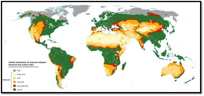
Current Trends and Patterns of Desertification and Land Degradation
The risk of desertification is widespread and spans more than 100 countries, hitting some of the poorest and most vulnerable populations the hardest, since subsistence farming is common across many of the affected regions.
- According to the European Commission's World Atlas of Desertification, 2018
- Over 75% of Earth's land area is already degraded, and over 90% could become degraded by 2050.
- Globally, a total area half of the size of the European Union (4.18 million km²) is degraded annually, with Africa and Asia being the most affected.
- According to IPCC Special Report on Climate Change and Land,
- The highest numbers of people affected are in South and East Asia, the circum Sahara region including North Africa and the Middle East including the Arabian Peninsula.
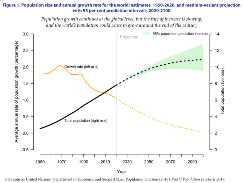
- The population in drylands is projected to increase about twice as rapidly as non-drylands, reaching 4 billion people by 2050. This is due to higher population growth rates in drylands. About 90% of the population in drylands live in developing countries.
- Desertification hotspots, as identified by a decline in vegetation productivity between the 1980s and 2000s, extended to about 9.2% of drylands, affecting about 500 million people in 2015.
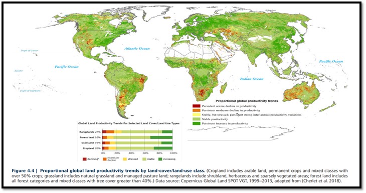
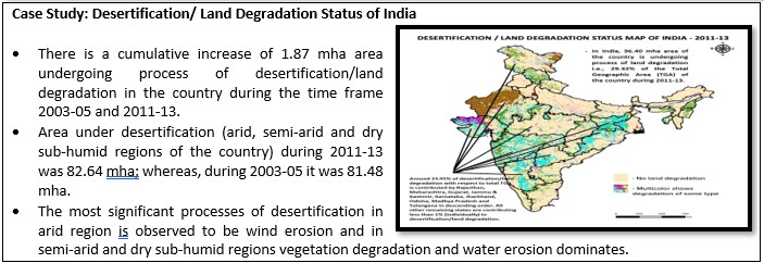
Drivers of Desertification and Land Degradation
According to a recent report from the Intergovernmental Science-Policy Platform on Biodiversity and Ecosystem Services (IPBES), land degradation is almost always the result of multiple interacting causes.
Climate change and Desertification
- Looking first at the role of the climate, a significant factor is that the land surface is warming more quickly than the Earth’s surface as a whole. Adding to this heat stress, Climate change affects the frequency and magnitude of extreme events like droughts and floods.
- Both natural variability in climate and global warming can also affect rainfall patterns around the world, which can contribute to desertification. Rainfall has a cooling effect on the land surface, so a decline in rainfall can allow soils to dry out in the heat and become more prone to erosion. On the other hand, heavy rainfall can erode soil itself and cause waterlogging and subsidence.
- The main effect of climate change is through aridification, a progressive change of the climate towards a more arid state – whereby rainfall decreases in relation to the evaporative demand – as this directly affects water supply to vegetation and soils.
- Climate change is also a contributing factor to wildfires, causing warmer – and sometimes drier – seasons that provide ideal conditions for fires to take hold. And a warmer climate can speed up the decomposition of organic carbon in soils, leaving them depleted and less able to retain water and nutrients.
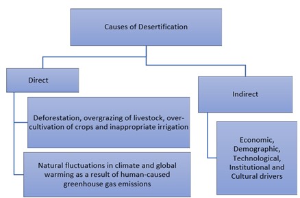
Food production is also a major driver of desertification. Growing demand for food can see cropland expand into forests and grasslands, and use of intensive farming methods to maximise yields. Overgrazing of livestock can strip rangelands of vegetation and nutrients.
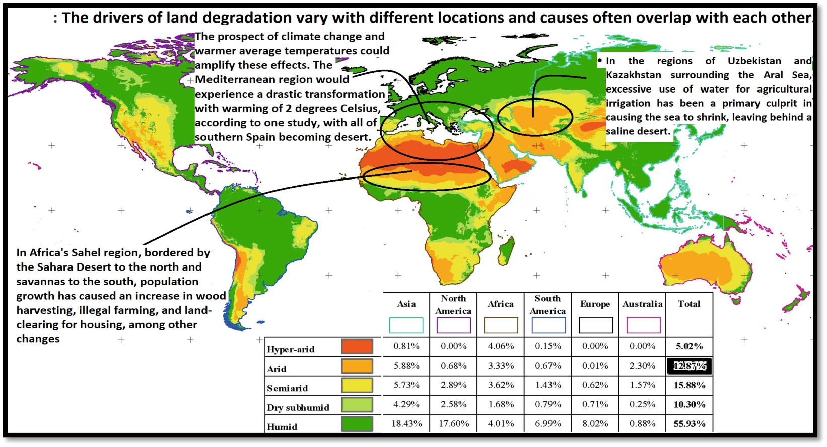
Impacts of Desertification
- Impacts on ecosystems and their services in drylands: desertification processes such as soil erosion, secondary salinisation, and overgrazing have negatively impacted provisioning ecosystem services in drylands, particularly food and fodder production. Among regulating services, desertification can influence levels of atmospheric CO2.
- Impacts on biodiversity: Over 20% of global plant biodiversity centres are located within drylands with having high genetic diversity. Species richness decreased from 234 species in 1978 to 95 in 2011 following long periods of drought and human driven degradation on the steppe land of south-western Algeria.
- Impacts on socio-economic systems: The combination of pressures coming from climate change and desertification will diminish opportunities for reducing poverty, enhancing food and nutritional security, empowering women, reducing disease burden, and improving access to water and sanitation. Land degradation negatively impacts one fifth of the planet’s land area and the livelihoods of 3.2 billion people, 40% of the global population.
- Impacts on agriculture : The UNCCD estimates that around 12 million hectares (mha) of productive land are lost to desertification and drought each year. This is an area that could produce 20 million tonnes of grain annually.
- Globally, one fifth of earth’s land area – more than 2 billion hectares – is degraded, including more than half of all agricultural land. Unless we change how we manage soil, over 90% could become degraded by 2050.
- Financial impacts:In Niger, for example, the costs of degradation caused by land use change amounts to around 11% of its GDP. Similarly in Argentina, the “total loss of ecosystem services due to land-use/cover change, wetlands degradation and use of land degrading management practices on grazing lands and selected croplands” is equivalent to about 16% of its GDP.
- Increase in sand and dust storms. These natural phenomena – known variously as “sirocco”, “haboob”, “yellow dust”, “white storms”, and the “harmattan” – occur when strong winds blow loose sand and dirt from bare, dry soils. Research suggests that global annual dust emissions have increased by 25% between the late nineteenth century and today, with climate change and land use change the key drivers.
Mitigation strategies
- Integrated crop–soil–water management: Actions include planting a diversity of species including drought-resilient ecologically appropriate plants, reducing tillage, applying organic compost and fertiliser, adopting different forms of irrigation and maintaining vegetation and mulch cover. Integrated crop–soil–water management may also deliver climate change mitigation benefits through avoiding, reducing and reversing the loss of Soil Organic Carbon.
- Socio-economic responses:
-
- The use of indigenous and local knowledge enhances the ability to address desertification.An example is the numerous traditional water harvesting techniques that are used across the drylands to adapt to dry spells and climate change. These include creating planting pits (zai, ngoro) and micro-basins, contouring hill slopes and terracing.
- Livelihood diversification through non-farm employment increases the resilience of rural households against desertification and extreme weather events by diversifying their income and consumption.
- Policy responses: Policy responses are classified in two ways: those which seek to combat desertification under changing climate; and those which seek to provide alternative livelihood sources through economic diversification.
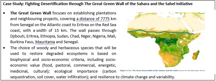
Case Study: Fighting Desertification through The Great Green Wall of the Sahara and the Sahel Initiative
- The Great Green Wall focuses on establishing plantations and neighbouring projects, covering a distance of 7775 km from Senegal on the Atlantic coast to Eritrea on the Red Sea coast, with a width of 15 km. The wall passes through Djibouti, Eritrea, Ethiopia, Sudan, Chad, Niger, Nigeria, Mali, Burkina Faso, Mauritania and Senegal.
- The choice of woody and herbaceous species that will be used to restore degraded ecosystems is based on biophysical and socio-economic criteria, including socio-economic value (food, pastoral, commercial, energetic, medicinal, cultural); ecological importance (carbon sequestration, soil cover, water infiltration); and resilience to climate change and variability.
- These options are mutually complementary and contribute to all the three hierarchical elements of the Land Degradation Neutrality (LDN) framework, namely, avoiding, reducing and reversing land degradation. An enabling policy environment is a critical element for the achievement of LDN.
Improving capacities, providing higher access to climate services, including local-level early warning systems, and expanding the use of remote sensing technologies are high-return investments for enabling effective adaptation and mitigation responses, that can help address desertification.
Where can we use it?
Geography Optional, P1: Climatology (Climate change), Biogeography (Degradation), Environmental Geo (Management and Hazards), Economic Geo (Agriculture, LTG), Population Geo (Migration), Regional Planning (Environmental issues, Regional developmental). P2: Physical setting (Droughts), Resources (Land, Forest), Agriculture (Agro-climatic planning and regionalisation), Cultural settings (Migration), Regional Development and planning (Desert, Drought prone area planning), Contemporary (Desertification and soil erosion). GS1 (Geophysical phenomena-desertification), GS3 (Environmental degradation and conservation).
MARINE PROTECTED AREA IN INDIA AND THREATS
- Why in news?
The Ministry of Environment, Forest & Climate Change (MOEF&CC) has launched “Management Effectiveness Evaluation (MEE)” for marine Protected Areas in 2021.
- Background:
- According to IUCN, Marine Protected Area (MPA) is defined as geographical space, recognised, dedicated and managed in marine ecosystem through legal or other effective means, to achieve the long-term conservation of nature with associated ecosystem services & cultural values. The first MPA in India was designated in 1967, there are nearly 128 MPAs in India.
- Challenges to marine protected areas: Governance issues
- Laws and policies rarely acknowledge ecological specificity of marine ecosystem and instead support a uniform “blueprint” approach, biased towards charismatic species and terrestrial ecosystems. Example: Wildlife Protection Act (1972) focus mainly on terrestrial areas - the latest amendments (2006) and amendment bills (2013 and 2017) focus almost entirely on the conservation and protection of tigers, rhinos, and forests.
- Intersecting laws: The wildlife act intersects with other laws such as the Coastal Regulation Zone (CRZ) Notification (amended in 2018), and the respective Marine Fisheries Regulation Act (MFRA) passed by states and union territories.
- No clear cut demarcation of areas, which is important because it reinforces the state’s claim in both practical and performative ways: it helps to reinforce a visual boundary as well as to detect and defend the area from trespassers.
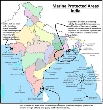
- Developmental issues :
- Yet to evolve a formal definition of marine property rights and hence there is no legal framework to support claims over marine spaces and resources that have been traditionally managed by certain communities
- Routine work such as the construction of footpaths and collection of solid waste proceeds at a very slow pace.
- Routine land-based management practices are grafted on to a dissimilar region of seascape.
- The absence of integrated approaches, communities that use marine resources begin to face severe restrictions and eventually, strongly oppose MPAs
- Unsustainable resource exploitation:
- Unsustainable practices like Bottom trawling, Cyanide fishing, Dynamite fishing, Ghost fishing and multitude of factors, such as size of the area, its habitat heterogeneity, life history traits of the local species, the decision-making process followed, and the type of monitoring adopted, all constrain ecological effectiveness. Recently in 2021, Odisha saw dead bodies of Olive Ridley Turtles at Gahirmatha Marine Sanctuary, due to fishing nets & use of trawlers in the protected areas.
- Poor seascape skills
- The human resources lack seascape skills to manage the problem and hardly know the cause of prevailing ecological problem & its severity leading to negligence & loss of natural ecosystem.
- Due to fiscal constraints, many MPAs often face a shortage of seaworthy patrol boats.
- Conservation approaches
- Regional development through ecosystem and sustainable approach
- For the integrated management of land, water and living resources that promotes conservation and sustainable use in an equitable way and to recognizes that humans, with their cultural diversity, are an integral component of ecosystems.
- As per Taylor – Neo Determinism – the environment compels to stop wrong steps for economic growth like fishing, sand-mining & correct its action by following eco-friendly methods based on regional problems.
- Geographical mapping and use of statistical techniques
- Case study: Gulf of Cambay oil spills, Gujarat Geographical mapping through satellites, helped in proper management and rehabilitation methods and timely measures to save the marine ecosystem of the region.
- The statistics techniques will quantify the result & bring its performance of inspection, to have development of MPAs.
- Regional development through ecosystem and sustainable approach
-
- Community planning
- People participation in concordance with Principle of Ecology - “SUSTAINED LIFE ON THE EARTH IS A CHARACTERISTICS OF ECOSYSTEM” will pave to harmonious relation between Man & Environment.
- Thus, environmental ethics strengthen the environment-man bonding.
- Example – Indonesia and Philippines have started community-driven efforts in the form of Locally Managed Marine Areas (LMMAs) and these have benefitted both conservation & livelihood.
- Community planning
- Road to sustainability
- To support holistic and inclusive efforts, reframe the wildlife act to supports a range of management approaches that take into account the biophysical diversity of the country and the mixture of claims, rights and regulations of the region.
- Conservation of bio-diverse MPA will bring positive results like no extinction of species, solving problems of invasive alien species & many more.
Where this article can be used - Sustainable Development, Ecological Issues, Marine Pollution, Ecology and its principles, Influence of man on ecology and environment, Environmental legislation & Environment Management.
Potential of Organic Farming in India
- Why in news: According to Organic Farming Global Market Report 2021: The global organic farming marketis expected to grow from $95.38 billion in 2020 to $103.36 billion in 2021 at a compound annual growth rate (CAGR) of 8.4%. The market is expected to reach $151.36 billion in 2025 at a CAGR of 10%.
- Background: Organic farming defined as ‘an ecological production management system that promotes and enhances biodiversity, biological cycles and soil biological activity’, based on minimal use of off-farm inputs and on management practices that restore, maintain and enhance ecological harmony.
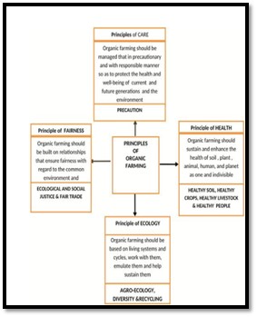
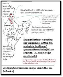
Potential of organic farming in India
-
- India has the potential to become a major organic producing country given the international demand for our farm products, different agro-climatic regions for the cultivation of a number of crops, the size of the domestic market and above all the long tradition of environment friendly farming and living.
- India is endowed with various types of naturally endowed forms of nutrients in different parts of country and will help for organic cultivation of crops substantially.
- Organic agriculture can become low cost, sustainable option of farming in the country, particularly by the small farmers in rain fed areas and helps to improve their food and income security.
- In domestic urban centre’s, with Increasing health consciousness and increasing disposable income, diverse range of consumers is now showing more interest in reconnecting with the sources of their food and phenomenon finds its expression in the increasing popularity of organic bazaars.
- Organic farming prospects in India will help development of niche products regionally like tea/coffee products in hilly regions of India.
- Benefits of Organic Farming
- Very economical- it uses no expensive fertilizers, pesticides, HYV seeds for the plantation of crops. With the use of cheaper and local inputs, a farmer can earn a good return on investment.
- Nutritional benefits and health safety: As organically grown foods are cultivated without the use of pesticides and sewage sludge, they are less contaminated with pesticide residue and pathogenic organisms such as Listeria monocytogenesor Salmonella or Escherichia coli, thus ensure better nutritional benefits and health safety.
- Environmental impact: Organic farming is less harmful to the environment as it does not allow synthetic pesticides, most of which are potentially harmful to water, soil, and local terrestrial and aquatic wildlife and organic farms are better than conventional farms at sustaining biodiversity, due to practices like crop rotation.
- Socio-economic impact and ensured social sustainability:
- Organic cultivation requires a higher level of labor, hence improve Social Sustainability by enabling rural poor to get benefit from.
- Promoting gender equality through full participation of vibrant rural communities and thus decreasing suicidal rates among the farmers.
- Can help reduce distress Rural to Urban migration.
- Organic farming clusters can become Growth pole causing overall development of the region.
Example: Organic farming appears to generate 30% more employment in rural areas and labor achieves higher returns per unit of labor input.
Organic farming and sustainable development: Basic approach to organic farming for the sustainable environment includes :
-
- Improvement and maintenance of the natural landscape and agro-ecosystem..
- Acknowledgement of the virtues of indigenous know-how and traditional farming system.
- Challenges in organic farming:
- Organic farming in India has fewer choices, and off-season crops are limited.
- Less productivity of organic food is expected to hinder the organic farming market. According to a study by USDA, the yield of organic farming is significantly less compared to the conventional farming.
- The main disadvantage of organic farming is the lack of marketing of the products and Inadequate supporting infrastructure.
- Schemes: Paramparagat Krishi Vikas Yojana (PKVY), Mission Organic Value Chain Development for North Eastern Region (MOVCDNER), Rashtriya Krishi Vikas Yojana (RKVY), Integrated Development of Horticulture (MIDH) and Network Project for Organic Farming.
- Where can we use it:
Paper1-Biogeography and Environment Geography (conservation), Regional Planning, Economic Geography (Agriculture region type, food security).
Paper2- Agriculture (Green revolution and its impact, Regionalization, Agro-ecology, Agro-climatic zones).
Laschamps
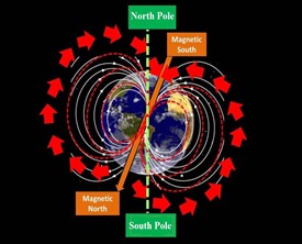
- The Laschamps event was a geomagnetic excursion (a short reversal of the Earth's magnetic field) occurred 41,400 years ago, during the end of the Last Glacial Period.
The event lasted about 1000 years.
- It is known from geomagnetic anomalies discovered in the 1960s in the Laschamps lava flows in Clermont-Ferrand, France.
- Unlike geomagnetic reversals, an excursion is not a permanent re-orientation of the large scale magnetic field, rather represents a dramatic, short-lived change in the field intensity.
- It’s short-lived because, during excursions, the field reverses in the liquid outer core, but not in the solid inner core.
- Significance: This resulted in weakened Earth’s magnetic field and exposed it to the Sun’s harmful ultraviolet radiation which caused devastating global and environmental impacts (such as extinction of Neanderthals, extinction of Australian mega fauna, shift in tropical Pacific rain belt).
What if it occurs now? : It will lead to geomagnetic storms which disrupt satellites and communication systems, also it can lead to rapid short term climate cooling periods.
DEMOGRAPHIC TRAP
Concept: The concept of the demographic trap first appeared in the annual report of the Worldwatch Institute in 1987.
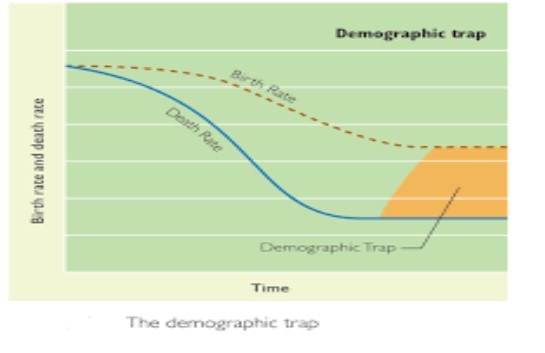
What is it: It is the situation that arises in a country or region when the population exceeds the carrying capacity of its local ecosystem, and there is nowhere for the people to go, and the economy produces insufficient goods or services to exchange for food and other essentials. In simple terms, it refers to the combination of high fertility and declining mortality in developing countries, resulting in a period of high population growth rate (PGR) such as Gaza Strip, Yemen, Egypt, etc.
When does this arise: It is generally observed in the stage 2 of demographic transition because of falling living standards reinforce the prevailing high fertility, which in turn reinforces the decline in living standards. It results in more poverty, where people rely on more children to provide them with economic security.
HEAT DOME - Edukemy Current Affairs
- A heat dome is essentially a mountain of warm air built into a very wavy jet stream, with extreme undulations.
- When the jet stream — a band of strong wind in the upper levels of the atmosphere — becomes very wavy and elongated, pressure systems can pinch off and become stalled or stuck in places they typically would not be.
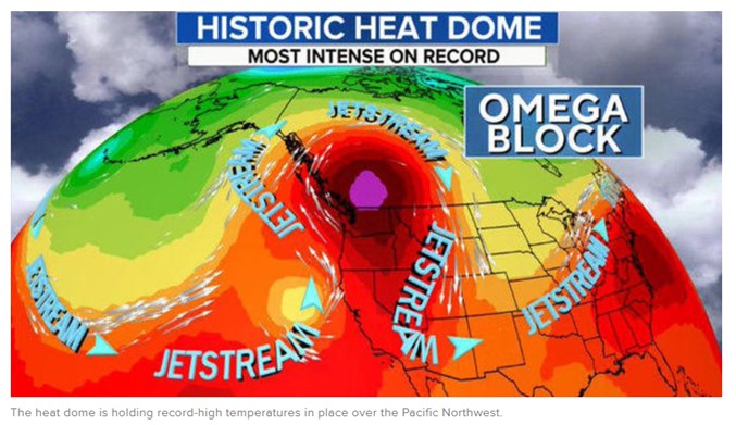
Figure 1
- As per the figure 1, a ridge of high pressure, which is the heat dome, has become lodged in the Pacific Northwest.
- It is acting as a block in the atmosphere, not allowing the weather to move. The specific type of block is called an Omega block, because it looks like the Greek letter Omega, and the hot air is pooling inside.
- In addition, the local conditions like, winds moving downslope from the mountain downwards into the cities like Seattle, & Portland; that downward motion causes heat as well.
- Example: There was rise in the temperature in Portland city in USA,recently. The temperature has reached at highest point to 46 degree Celsius after 1981.
- Even, the rise in temperatures has been reported from the Pacific Northwest (figure 1) and some parts of Canada, which are part of historic heat-wave that lasted over a week, a result of a phenomenon referred to as a “heat dome”.
- The increasing global temperature due to Global Warming & the wavy-Jetstream has intensified the heating effect. This leading to Heat-Dome.
- Example:- The region of California is witnessing extreme heat due to climate change.
- The effect of climate change & Jetstream are still studied by the researchers for its validation in contributing towards heat-dome.
Primate City
- The Primate city is the country’s leading city & usually disproportionately larger than others in the system.
- In other words, a Primate City has a stratum of small towns dominated by a very large city with an absence of intermediate centers. Examples are Kathmandu (Nepal), Thimpu(Bhutan) and others.
- The law of Primate City was developed by Mark Jefferson in 1939.
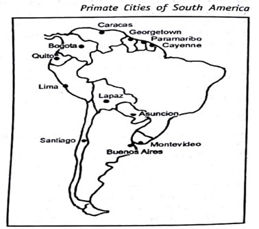
- The major causes for development of Primate city are:-
-
- Small territorial extent of the country.
- High density of population.
- Low per Capita income.
- A high degree of dependence upon agricultural exports.
- High rate of population growth.
- In many cases, a formal colonial status.
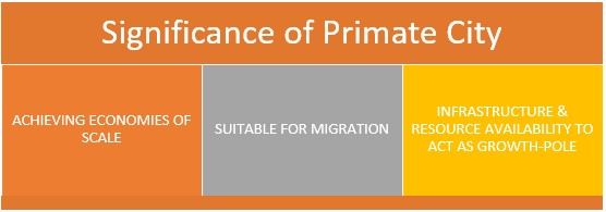
- There is no primate city in India at the national level at present because of the large size of the country, its colonial heritage, and weaknesses in the Nationalists forces in the country.
- But there are primate city in different states of India.
- Later in 1949 G.K Zipf attempts to express the relationship with nature of town & population. Many geographers then see Primate City concept of Jefferson as a sub-set of Rank Size Rule.
PINK SNOW
Context: In the Alp’s there was low snowfall and high atmospheric temperatures in 2020-21 which created the perfect environment for the algae to grow.
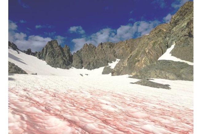
How is it formed: These are formed when the sun heats up and snow starts to melt. The freezing temperature and presence of liquid is apparently the ideal environment for a certain type of algae, Chlamydomonas nivalis, to bloom, turning the snow into the saturated shade which attracts more sun and accelerates the melting process. The algae has a chemical pigment called astaxanthin that gives a pink colour to the glaciers. It is believe that this could be because of unusually warm weather and sewage runoff—factors that contribute to freshwater and ocean algal blooms.
Also known as the “Watermelon snow” due to the texture and smell of the same. When are they formed: In general they bloom in the spring, but in recent times there has been a sudden increase in its occurrence.
Blue Bioeconomy Development: Iceland
Background: The fishing industry is a base industry in Iceland, and has a total contribution of 26% to GDP. However, 43% of captured fish resources used to end up either as wastage or discarded material. But today, several companies in Iceland such as Iceland Ocean Cluster, Codland have adopted the Blue Bioeconomy methodology to turn waste into high-value products and achieved near 100 % biomass utilization in the fishing industry.

Methods adopted by Iceland to achieve near 100 % Biomass Utilization?
- Waste from traditional cod fisheries and processing is used for biomass feedstock and producing other bio products such as fish oil, fish meal and collagen peptides.
- Innovative methods such as hydrolization using enzymes to produce high-value products.
- Incentivizing private companies had helped in integration of country’s fishing and processing industries under 100% fish project.
- Established centres of excellence to promote Bioeconomy collaboration in the Nordic region.
- Being a partner in the Blue Bioeconomy Cofund to promote Research on blue Bioeconomy which involves Iceland and 15 Coastal EU countries.
- The creation and development of markets for bio products.
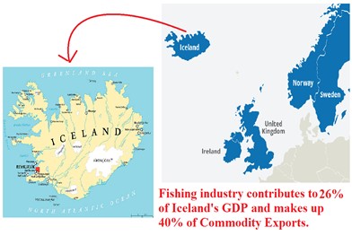

This can be replicated in India which is having 7517 km long coastline.
Where this case study can be used?
This case study can be used in topics related to Paper 1 (Sustainable development, Conservation measures, regional development, food security), Paper 2 (Marine resources, aqua culture, Coastal area development).
Tourism In God’s Own Country
WHY IN NEWS?
Kerala Travel Mart 2021 (KTM), the country’s biggest B2B tourism event was inaugurated recently, that would give an aggressive push to the state’s tourism that suffered a huge blow in the wake of the COVID pandemic.
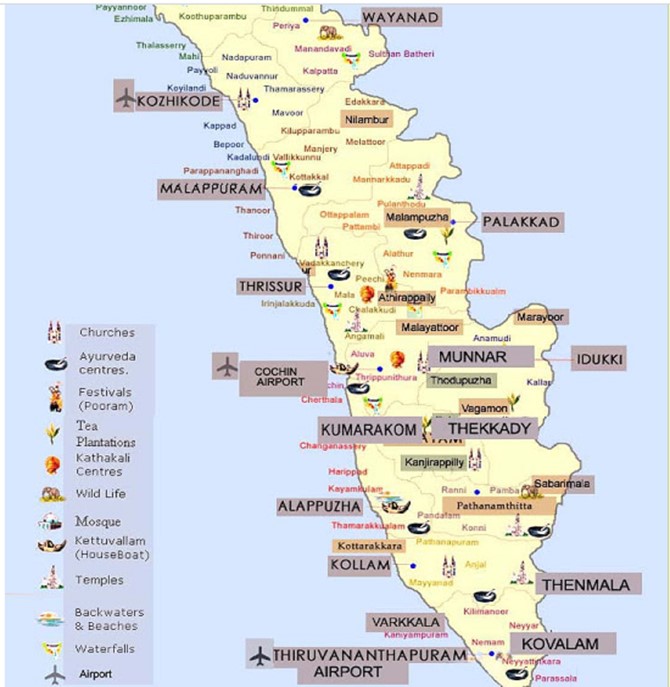
Major Tourist Spots in Kerala
Unique Kerala Model of Sustainable Tourism
- Regional Planning of Tourism
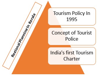
- Use of Space and Technology
- Marketing information system contributes in increasing the leadership and progress of a particular business in the industry and this scope of MIS are wide and more incorporating in market research strategies.
- With MIS the destination marketing organization of Kerala would be able to handle efficiently.
- Decentralisation for Sustainable Tourism
- Destination Management Councils are formed to commence and preserve the tourism projects completed in tourism destinations and to evaluate the basic infrastructure, security, protection, encroachment, new schemes.
- Some of the schemes developed are:
- ‘My Village, Tourism friendly Village’: Scheme launched to identify and develop unknown rural tourist destinations with the participation of Local bodies.
- ‘Wake up to Malabar’: Comprehensive plan to promote North Kerala.
- ‘Let’s Learn’: HR initiative for skill development in the tourism and hospitality sector.
Future Opportunities
- Growth in Tourism Sector
- Kerala can contribute to the travel and tourism sector to India’s GDP which is expected to increase from Rs. 15.24 lakh crore (US$ 234.03 billion) in 2017 to Rs. 32.05 lakh crore (US$ 492.21 billion) in 2028.
- Sustaining Culture & Ethnicity
- Focusing on sustaining unique tourism products based on its ethnicity like Puttu - steamed rice-cake and other services including Kerala culture hospitality.
- Transportation and ICT based Development
- Kerala Government has co-operated with the Central’s UDAN scheme to connect the tourist spot with airstrips nearby.
- Even other states like Uttarakhand, Himachal Pradesh & Bihar can replicate the Kerala’s Model of Sustainable tourism.
The article can be used for-Sustainable Development, Eco-Tourism.
Saheed Dweep
|
Saheed Dweep
|
|
Raini Village
|
|
Srinagar
|
|
Kasaragod
|
|
Balasore
|
|
Buxwaha
|

Share the article
Get Latest Updates on Offers, Event dates, and free Mentorship sessions.

Get in touch with our Expert Academic Counsellors 👋
FAQs
Geography Current Affairs focuses on the contemporary issues, events, and developments in the field of geography. It covers recent geographical phenomena, environmental changes, geopolitical shifts, and related news. This differs from regular geography studies which may focus more on foundational concepts, historical contexts, and theoretical frameworks.
Updates are provided regularly to ensure that subscribers stay informed about the latest developments in geography. Typically, updates are provided on a fortnightly basis, depending on the frequency of significant events and changes in the field.
Absolutely. Geography Current Affairs serves as a valuable resource not only for Geography optional but also for GS papers, especially GS Paper 1 (covering Indian Heritage and Culture, History, and Geography of the World and Society) and GS Paper 3 (covering Technology, Economic Development, Biodiversity, Environment, Security, and Disaster Management). It aids in building a holistic understanding of various topics and strengthens answer-writing skills by incorporating contemporary examples and perspectives.
Geography Current Affairs holds immense importance for UPSC preparation, particularly for aspirants opting for Geography optional. It helps candidates stay updated with the latest developments, geographical phenomena, environmental issues, and geopolitical shifts worldwide, aligning them with the dynamic nature of the subject as tested in the UPSC examinations.

