12 Feb
Malnutrition Vs Rising Economic Growth in India- An Unresolved Paradox
In news
In the 2021 Global Hunger Index, India ranks 101st out of the 116 countries, with the hunger situation in the country categorised as ‘serious’.
Background
- In the last 2 decades, per capita income more than tripled, yet the minimum dietary intake fell. The gap between rich and poor increased during this period of high economic growth.
- Recent data from India’s National Family Health Survey (NFHS)-5 (2019-21) shows that one-third of all children under five years of age are stunted (35.5%) and underweight (32.1%), and child nutrition levels barely improved from NFHS-4 (2015-16).
- In fact, the proportion of underweight and stunted children has increased in some states, including economically advanced states of Maharashtra and Kerala.
- Obesity has also risen among adults. The data shows 22.9% of the men and 24% of the women surveyed were obese, up from 18.9% and 20.6%, respectively, in 2015-16.
- Maharashtra and Gujarat have the largest number of malnourished children in the country.
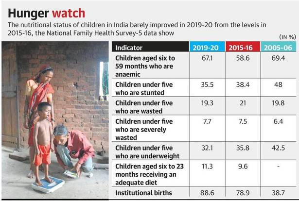
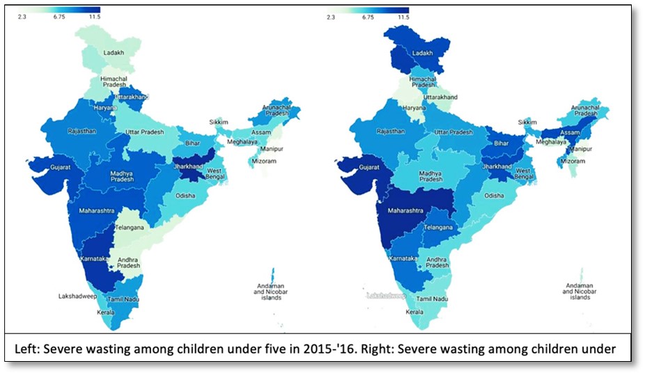
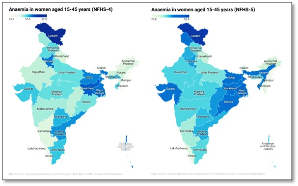
The Paradox: Rising Economic Growth Vs Slow rate of Malnutrition Reduction
Cross-country evidence shows that economic growth and consequent rise in average incomes reduce child undernutrition, and decline in prevalence of child underweight tends to be nearly half the rate of growth of per capita Gross Domestic Product (GDP).
- As per World Bank data, between 1990 and 2015, the average per capita GDP in India grew at an average annual rate of 4.5%. This income growth should have provided a potent force to address the problem of childhood undernutrition.
- If the observed relationship between GDP per capita and undernutrition held perfectly in India, this would have eliminated childhood undernutrition during this 25-year period.
- Yet, India’s progress on this front has been sluggish as evident from the NFHS 5 data.
- Alarming rate of malnutrition: Over 33 lakh childrenin India are malnourished and more than half of them fall in the severely malnourished category with Maharashtra, Bihar and Gujarat topping the list.
- There are 76 lakh severely acute malnourished children (SAM) and 15.46 lakh moderately acute malnourished (MAM) children as of October 14, 2021.
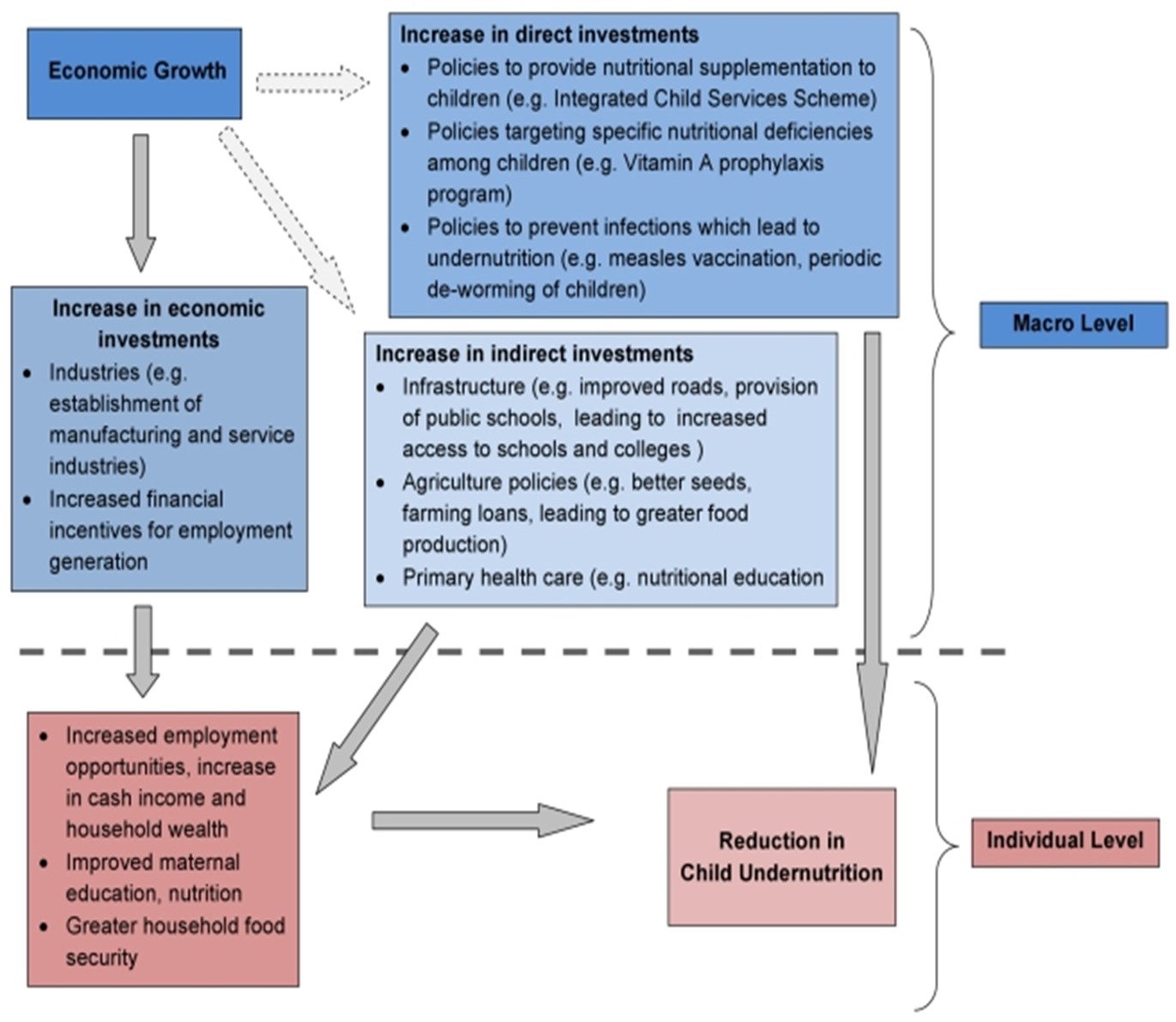
Pathways connecting state-level economic growth and child undernutrition
Reasons for such paradox
- Exclusionary nature of India’s growth: India’s growth has benefitted a small section of country’s populace, while leaving behind a majority.
- In particular, the prevalence of undernutrition is higher among children of historically marginalized communities of Scheduled Castes/Tribes.
- Gender discrimination: The gender differentials in treatment favoring boys over girls in food and health care, results in higher undernourishment among girls which in turn manifests into women bearing below normal weight babies, leading to intergenerational cycle of undernourishment.
- India has among the highest proportion of low-weight babies which means the problem of undernutrition starts in the womb, which is rooted in low status of women.
- Poor hygiene and sanitation: The generally poor hygiene and sanitation conditions that lead to disease often mean that even when there is enough food to go around, food consumed is inadequately absorbed in the body for it to achieve optimal development.
- Socio-cultural norms around breastfeeding also inhibit child growth, and 40% of Indian children under the age of six months are not exclusively breastfed, against the recommended guidelines.
- Declining Nutritional Intake: Between 1983 to 2011- 12, the average daily per capita consumption of both energy and protein decreased in rural India while in urban areas, there was no consistent trend. This decline has happened despite the increase in household income.
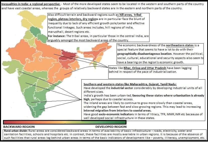
- Regional inequalities: This is the reflection of D M Smith’s Welfare Geography involving the explanation of Who gets What, Where and How.
- Who- the population in need like poor, SC/STs, Women and Children
- What – The support like foodgrains, fortified food etc.
- Where – The space/Location like rural or Urban, Tribal or Hilly regions etc.
- How – The mechanism to deliver services such as Aadhaar, PDS, NFSA etc.
- According to the Food and Nutrition Security Analysis, India, 2019 report, following are the findings:
- Inter and Intra State Variations in Malnutrition: The prevalence of stunting in children under five is the highest in Bihar (48%), Uttar Pradesh (46%), Jharkhand (45%), and Meghalaya (44%) and lowest in Kerala and Goa (20% each). Jharkhand also has the highest prevalence of underweight (48%) and wasting (29%).
- Vulnerable Pockets and Sections in India: The highest levels of stunting and underweight are found in Jharkhand, Bihar, Uttar Pradesh, Madhya Pradesh, Gujarat, and Maharashtra. Few states have a very high burden of malnutrition. The poorest quintile of the population is the most vulnerable in terms of stunting.
- In addition to the earlier mentioned states, the two poorest quintile groups in Haryana, Meghalaya, Karnataka, Rajasthan, and Punjab have high levels of stunting.
- At the national level, among social groups, the prevalence of stunting is highest amongst children from the Scheduled Tribes (43.6%), followed by Scheduled Casts (42.5%) and Other Backwards Casts (38.6%).
- The prevalence of stunting in children from Scheduled Tribes in Rajasthan, Odisha and Meghalaya is high while stunting in children from both Scheduled Tribes and Scheduled Castes is high in Maharashtra, Chhattisgarh, and Karnataka.
- Rural Vs urban divide: Under-nutrition is more prevalent in rural areas, again mainly due to low socioeconomic status. Also, the changing dietary habits such as increased intake of junk foods in urban areas are leading to hidden hunger and obesity.
- Economic inequalities: In India, top 10% holds 57% of the total national income while the bottom 50 per cent’s share is just 13% in 2021, according to the latest World Inequality Report 2022. This reflects the poor distribution of GDP growth benefits to a large population and restricts the access to high-cost nutritious food.
- Conflicts and Disaster induced displacements: These people are forced to move to other places, which are foreign to them, and they are derived from the basic necessities of life, which starts a vicious cycle of poverty and thus hunger.
- Climate change – Uncontrolled anthropogenic activities have caused drastic ecological imbalances doing on a massive scale. Even the minimum change in a place’s climate can have a drastic impact on its flora and fauna such as loss of nutrition in natural plants.
- For instance: The rising sea level has caused major causes of worry for the low-lying coastal regions. In the last couple of decades, it can be seen how many natural disasters like cyclones, droughts, and floods have increased. This will cause major harm to the infrastructure and agriculture, all of which results in the suffering of the poor, thus hunger.

Way forward
Malnutrition in India is a complex problem that requires systemic efforts of the public administration and service delivery systems, as well as engagement from the community.
- Welfare approach to problem of malnutrition in India: To guide public policy toward increasing the total good of society, using tools such as cost-benefit analysis and social welfare functions.
- District-level decentralized interventions to address malnutrition in India. For example, Angul district in Odisha, which has a large geographically isolated tribal population, has periodic grievance redressal camps set up in areas far from the Anganwadi centers to provide ICDS services.
- Increasing awareness: Need to address gaps and inefficiencies in the present system through public awareness, community engagement and empowerment, while such an intervention would assist the community in realizing their rights and entitlements, and then act as a deterrent to inefficiencies and gaps, it would also help in developing community-based solutions to malnutrition, unburdening the stressed public healthcare infrastructure.
|
Case study: The approach undertaken by Bangladesh has been successful and replicable in India.
|
Conclusion
Improvement in food consumption is a necessary but not a sufficient condition for overcoming the problem of malnutrition in India. Apart from inadequate food consumption, the other important causes of malnutrition are high incidence of gastrointestinal and respiratory infections and behavioural factors such as faulty child feeding and weaning practices, all of which contribute to the low absorption of nutrients from the food consumed. Economic growth, left to itself, may not have a dramatic impact on nutritional status in the near future, although it provides greater opportunities for public intervention. Effective and efficient food and environmental interventions are needed until all the citizens are adequately fed.
Where to use:
P1- Economic Geography
P2- Cultural Setting, Contemporary Issues
GS P1- Society and social issues
GS P2- Governance
Source:
- More hospital births, but limited gains in childhood nutrition: National Family Health Survey-5:
- Food Security and Nutrition: Vision 2020:
- Food and Nutrition Security Analysis:
- India:High Economic Growth has not Translated into Superior Nutritional Status for India:
- Nearly 18 lakh children in India severely malnourished: Centre:
Tribal areas & their challenges in India
Context:
During the COVID-19 pandemic, the vulnerabilities being faced by tribals were exacerbated and new challenges emerged for tribal populations.
Geographical and Demographic Profile
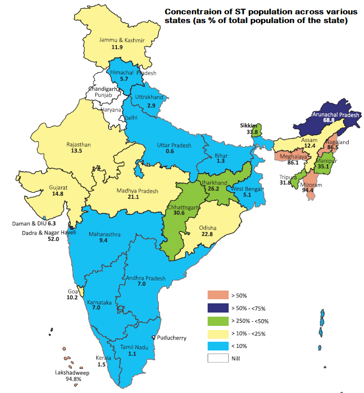
- The tribal population of the country, as per 2011 census, is 10.43 crore, constituting 8.6% of the total population.97% of them live in rural areas and 10.03% in urban areas.
- Broadly the STs inhabit two distinct geographical areas – the Central India and North- Eastern Area.
- More than two-third of the ST population is concentrated only in the seven States. (Refer pie chart).
Major challenges in the tribal areas:
- Remoteness: The tribal hamlets and habitations are located either in a valley or on the hill tops or in forests in most of the places. This remoteness enhances their seclusion and excludes them from major developmental activities.
- Case study: Tribes of Andaman and Nicobar Island- All the 5 tribal groups (Great Andamanese, Jarawas, Onges, Sentineles and Shom Pens) are listed under PVTGs. Their relative isolation prevented reach of government schemes and mainstreaming of economic activities. Remoteness proved a great hindrance in fighting against covid pandemic.
- Land Alienation: Land is their primary source of livelihood. But over a period, land have been grabbed not only through acquisition for public purpose but even fraudulent motives. The major states affected by alienation of land are Andhra Pradesh, Madhya Pradesh, Karnataka, and Gujarat.
- Case Study: The Koya tribes of Thottipampu (Telangana) have slowly lost their lands to non-tribal moneylenders and landlords, reducing their status to that of laborers in their own fields. The tribal inhabitants of Thottipampu have been fighting for the retrieval of their land, nearly 70 acres worth, since 1975 through legal means.
- Dislocation of Tribals: The displacement has taken place on account of various development projects like irrigation dams, under-ground coal mines, mineral based industries in various parts of the country. It is estimated that owing to construction of over 1500 major irrigation development projects since independence, over 16 million people were displaced from their villages, of which about 40% belong to tribal population. Nearly 60% of these large dams are located in central and western India where most of inhabitants are tribal communities.
- Case study: Between 1960 and 2006, Nagarhole has seen a displacement of 250 tribal habitations. Nearly 11,000 people have been displaced for construction of the Kabini dam and laying of power lines, in addition to the voluntary rehabilitation schemes.
- Deprivation of Forest Rights: The tribal communities being primitive, is based on forests areas for their survival. Although they live in isolation in forest areas, they are having harmonious relationship with forests and species. But the development of wildlife sanctuaries and eco-parks devastate their habitat and displace their living. The emergence of community forest management has led to growth of state control over their natural habitat.
- Examples: In 2014, around 450 families from indigenous Baiga and Gond communities were evicted to protect tigers in the Kanha Tiger Reserve. Also in Assam, more than 1,000 people from Bodo, Rabha and Mishing tribal communities were forcefully evicted from the Orang National Park in 2017.
- Socio-economic and demographic problems: This include health challenges (e.g., Sickle cell anemia), illiteracy, poverty, indebtedness, hunger and food insecurity, primitive agriculture, Small holdings, unaware of modern skills, high unemployment etc.
- Case study: The Central Indian Plateau is one of the poorest pockets in India and the Adivasi communities in this region ((Santhal, Munda, Ho, Gond, Oraon, etc) are the most deprived in the country and is characterised by low life expectancy at birth, low literacy rate, very high infant mortality rate, very high incidence of poverty (below poverty line), etc.
- In a scenario of reduced access to forests, declining soil fertility, continuous fragmentation of lands, loss of lands due to industrialisation and mineral extraction these Adivasis are finding it difficult to sustain their life by being in the village for the entire year.
- Gender issues: Adivasi communities in central India are patriarchal, patrilocal, patrilineal and patronymic. There are challenges related to giving land rights to women, witch-hunting and other forms of gender-based violence.
- Extinction of Primitive tribal culture: For instance, the Van-Raji tribe of Uttarakhand is listed amongst the 18 most threatened human groups in India. Van-Rajis have mostly settled in villages of Kumaon Himalayas, in Pithoragarh district, Uttarakhand. Mostly, they are cave-dwellers. In Askot Wildlife Sanctuary in Pithoragarh are the Raji villages of Kimkhola and Bhagtirwa. The tribe’s language, Raji, is declared ‘severely endangered’ by UNESCO for having a minuscule number of speakers.
- Migration and its effects: Available trends on tribal migration indicate that mostly migration of tribal population is distress-driven. They are joining the informal labour force as contract labourers in the construction industry and domestic workers in major cities. Currently, one of every two tribal households relies on manual labour for survival.
- Environmental degradation: For instance, Over 98% of India’s chromite reserve is found in the Sukinda region of Odisha where water, air and land is highly contaminated due to chromite mining and the local Adivasis suffer its impact.
- For tribal communities of Nuapada in Odisha, following silviculture, teak has been planted all over. This not only impacted the food security, but the domestic animals also get no fodder. Local villagers have failed to benefit from the teak plantations.


Conclusion
- Government is implementing Tribal Sub-Plan (TSP)/Schedule Tribe Component (STC)/Development Action Plan for Development of Scheduled Tribes (DAPSTs) for overall development of tribal people across the country including North Eastern Region (NER).
- TSP funds are spent by different Central Ministries / Departments under their schemes for various development projects relating to education, health, agriculture, irrigation, roads, housing, drinking water, electrification, employment generation, skill development, etc. for accelerated socio-economic development of Scheduled Tribes in the country.
- Various Schemes and laws such as The Scheduled Tribes and Other Traditional Forest Dwellers (Recognition of Forest Rights) Act, 2006, Eklavya Model Residential Schools (EMRS), Strengthening Education among ST Girls in Low Literacy Districts Scheme, Special Central Assistance to Tribal Sub-Scheme (SCA to TSS), the scheme of Development of PVTGs, Institutional Support for Development & Marketing of Tribal Products/Produce (Central Sector Scheme), Mechanism for Marketing of Minor Forest Produce (MFP) through Minimum Support Price (MSP) & Development of Value Chain for MFP and Support to Tribal Research Institutes (TRIs) etc. are being implemented.
Where to use
P1 and P2 : Tribal problems (Settlement Geography, Cultural Geography)
GS- P1 : Society, Geography
GS – P2 : Tribal areas governance problems
References
Oxbow lake
Oxbow lakes are U-shaped or curved bends in a river that are cut off from the main river flow, forming a lake. It can also be called a horseshoe lake, a loop lake, or a cutoff lake.
Formation: Due to continuous erosion and deposition along the sides of the meanders, the end of the meander loop comes closer and closer. In due course of time, the meander loops cut off from the river forming a lake called oxbow lake as shown in figure 1.
Key Features:
- Oxbow lakes are still water lakes. There is no stream or spring feeding the lake, and it doesn’t have a natural outlet. Oxbow lakes often become swamps or bogs, and they often dry up as their water evaporates.
- Oxbow lakes can be rich wildlife habitats. For example - Along the Amazon River in South America, oxbow lakes are common, and their still waters provide a unique habitat for plants and wildlife.

Sources:
Nunataks
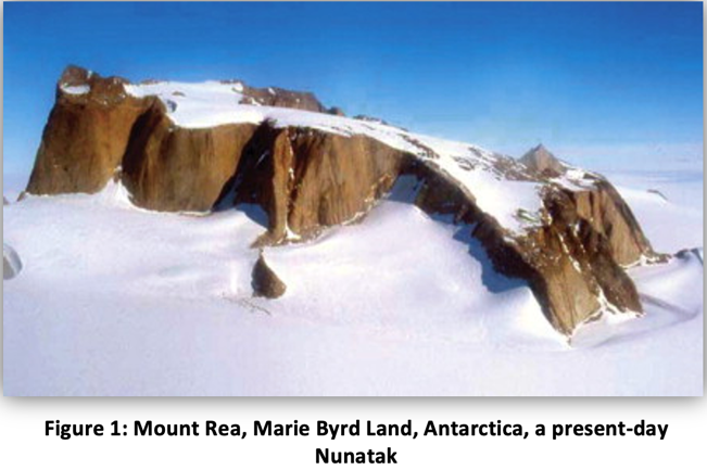
- Nunataks are mountain summits surrounded on all sides by glacier ice (as shown in Figure 1) the term is typically used in areas where a permanent ice sheet is present, and the Nunataks protrude above the sheet.
- They present readily identifiable landmark reference points in glaciers or ice caps and are often named. While some nunataks are isolated, sometimes they form dense clusters, for example - Queen Louise Land in Greenland.
- Nunataks are generally angular and jagged, which hampers the formation of glacial ice on their tops, although snow can accumulate on them. They usually contrast strongly with the softer contours of the glacially eroded land after a glacier retreats.
- Typically nunataks are the only places where plant life can survive on ice sheets or ice caps. Lifeforms on nunataks are frequently isolated by the surrounding ice or glacier, providing unique habitats.
Sources:
National Mission for a Green India
It aims at protecting; restoring and enhancing India’s diminishing forest cover and responding to climate change through adaptation and mitigation measures. It envisages a holistic view of greening that extends beyond tree planting.
The National Mission for a Green India or the commonly called Green India Mission (GIM), is one of the eight Missions under the National Action Plan on Climate Change (NAPCC).
The objective of the mission is to safeguard the biological resources of the nation and associated livelihoods against the peril of adverse climate change and to recognise the vital impact of forestry on ecological sustainability, biodiversity conservation and food-, water- and livelihood-security. The Mission would strive for enhancing carbon sinks in sustainably managed forests and other ecosystems, adaptation of vulnerable species/ecosystems to the changing climate and adaptation of forest-dependent communities.
Goals of the Mission:
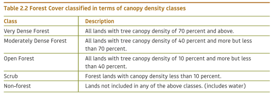
- Improvement in quality of forest cover and ecosystem services of forests /non-forests, including moderately dense, open forests, degraded grassland and wetlands (5 m ha).
- Eco-restoration/afforestation of scrub, shifting cultivation areas, cold deserts, mangroves, ravines and abandoned mining areas (1.8 m ha).
- Improvement in forest and tree cover in urban/peri-urban lands (0.20 m ha)
- Improvement in forest and tree cover on marginal agricultural lands/fallows and other non-forest lands under agroforestry /social forestry (3 m ha)
- Management of public forest/ non-forests areas (taken up under the Mission) by the community institutions
- Adoption of improved fuel wood-use efficiency and alternative energy devices by project-area households.
- Diversification of forest-based livelihoods of about 3 million households living in and around forests.
Sources:
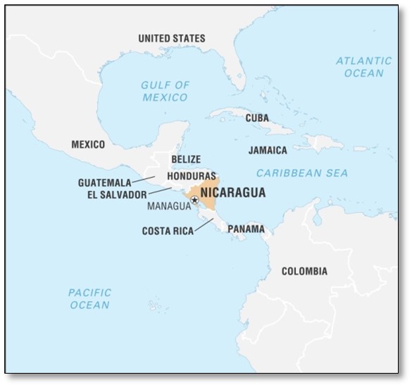
Case study: Nicaragua: Gender Equality as a Condition for Access to Water and Sanitation
- Challenges:
- In Nicaragua, 43 per cent of the population lives in rural areas, and only 46 per cent of this subset has access to potable water and sanitation.
- Water scarcity as the main problem- issue has been aggravated by population growth and the inherited environmental deterioration resulting from agricultural industrialization.
- The rural communities of this area faced a double tragedy: a period of drought (characteristic of the area) and high levels of contamination of the scarce water sources.
- For the members of the communities located in this area, the transport, use and management of water resources, as well as sanitation activities, were considered the responsibility of women and children. There were no mechanisms that supported gender equality to accomplish these tasks or social recognition of the problems the women faced as they conducted these activities.
- Program/Projects:
- Water, Latrines and Sanitation Project (PALESA) with goal of this to exercise the right and access to water for the 17,000 inhabitants living in the 45 communities of Nicaraguan. It sought to achieve this goal through the construction of toilets and new water systems.
- PALESA II was characterized by an institutional commitment to gender equality, which was deemed a priority in order to achieve the main project’s goal of improving the rural population’s quality of life.
- Gender inequalities were identified as a challenge to overcome in order to initiate community participation and to improve the project’s sustainability.
- Outcome:
- Increased involvement: The gender workshops conducted guaranteed greater women’s participation (56 per cent). Women were elected to more than 70 percent of the committees posts and gained posts which were previously filled by men, such as coordinators, vice-coordinators and financial managers.
- Once the water systems were installed, the female leadership with its capacity and quality moved to other initiatives.
- The methodology utilized in the education and training component increased the knowledge and the information levels of women living in rural areas, who were previously in a disadvantaged position.
- Moreover, the discussions also changed men’s perceptions about the management and use of water.
Reference - United Nation doc (pdf) on "GENDER, WATER AND SANITATION CASE STUDIES ON BEST PRACTICES"
Places in news
|
Jabalpur
|
|
Khijadiya wildlife sanctuary
|
|
Bongaigaon
|
|
Siruvani Dam
|
|
Sitamarhi
|
|
Aravalli Biodiversity Park
|

Share the article
Get Latest Updates on Offers, Event dates, and free Mentorship sessions.

Get in touch with our Expert Academic Counsellors 👋
FAQs
Geography Current Affairs focuses on the contemporary issues, events, and developments in the field of geography. It covers recent geographical phenomena, environmental changes, geopolitical shifts, and related news. This differs from regular geography studies which may focus more on foundational concepts, historical contexts, and theoretical frameworks.
Updates are provided regularly to ensure that subscribers stay informed about the latest developments in geography. Typically, updates are provided on a fortnightly basis, depending on the frequency of significant events and changes in the field.
Absolutely. Geography Current Affairs serves as a valuable resource not only for Geography optional but also for GS papers, especially GS Paper 1 (covering Indian Heritage and Culture, History, and Geography of the World and Society) and GS Paper 3 (covering Technology, Economic Development, Biodiversity, Environment, Security, and Disaster Management). It aids in building a holistic understanding of various topics and strengthens answer-writing skills by incorporating contemporary examples and perspectives.
Geography Current Affairs holds immense importance for UPSC preparation, particularly for aspirants opting for Geography optional. It helps candidates stay updated with the latest developments, geographical phenomena, environmental issues, and geopolitical shifts worldwide, aligning them with the dynamic nature of the subject as tested in the UPSC examinations.


