17 Jul
Impact of Changing Monsoon Pattern on Indian Agriculture
Why in News?
India has been witnessing variable monsoon for the past few years. This inconsistency in the monsoon rainfall pattern is an indication that extreme weather events might become the norm, rather than the exception, in the coming years and will have implications for agriculture and food security.
Introduction
The south-west (SW) monsoon, which generally begins in June and retreats by September, delivers more than 75% of India’s annual rainfall. It is crucial for the cultivation of rice, wheat, sugarcane and oilseeds in the country where farming employs over half of its people. The monsoon is key to replenishing reservoirs, groundwater and addressing water shortages.
Monsoon rainfall is mainly influenced by the global and local phenomenon like El Nino, northern hemisphere temperature, sea surface temperatures and snow cover. However, the year-to-year variation of rainfall and its distribution over different parts of the country have a strong impact on agriculture production. The alteration in the precipitation pattern due to climate change shows a direct or indirect impact over crop production.
The changing Pattern of SW Monsoon
The Ministry of Earth Sciences has published a report entitled "Assessment of Climate Change over the Indian Region". According to it,
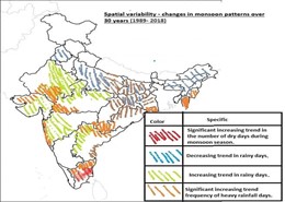
- The SW monsoon precipitation over India has declined by around 6% from 1951 to 2015, with notable decreases over the Indo-Gangetic Plains and the Western Ghats. According to IMD study, five states viz., Uttar Pradesh, Bihar, West Bengal, Meghalaya and Nagaland have shown significant decreasing trends in SW monsoon rainfall during the recent 30 years period (1989-2018).
- There is an emerging consensus that the radiative effects of anthropogenic aerosol forcing over the Northern Hemisphere have considerably offset the expected precipitation increase from GHG warming and contributed to the observed decline in summer monsoon precipitation.
- There has been a shift in the recent period toward more frequent dry spells (27% higher during 1981–2011 relative to 1951–1980) and more intense wet spells during the summer monsoon season. For instance, over central India, the frequency of daily precipitation extremes with rainfall intensities exceeding 150 mm per day increased by about 75% during 1950–2015.
- The drying trend may be attributed to a number of factors such as:
- increasing anthropogenic aerosol concentration over northern hemisphere which may cool northern hemisphere and slowing of the tropical meridional overturning circulation.
- significant increase in the duration and frequency of ‘monsoon- breaks’ (dry spells) over India since the 1970s.
- rapid warming of western Indian ocean (Indian Ocean Dipole effect) which reduces the meridional temperature gradient dampening the monsoon circulation.
- changes in land use/land cover.
- According to India Meteorological Department (IMD) study on changes in monsoon patterns over 30 years (1989- 2018), there is considerable spatial variability in precipitation changes as reflected by following maps-
- El-Nino also negatively affects the SW monsoon rainfall. La-Nina on the other hand, results into comparatively better monsoon rains in India.
- Climate change is not just affecting the southwest monsoon but is also driving changes in the north-eastern (NE) monsoon. The variability of northeast monsoon rainfall has increased in the period 1959–2016. Seasonal rainfall has increased over Tamil Nadu, Rayalaseema, as well as south peninsular India because of an increase in the number of high-intensity rainfall events in the recent period compared to 1901–1958.
Impacts of Monsoon Variability on Agriculture
Rainfall occurring over India during summer monsoon season significantly affects the agricultural production of the country by providing water for the two main crop growing seasons, Kharif(summer) and Rabi(winter). Therefore, variations in the monsoon rainfall affect the total food grain yield of India.
- Impact on Soil Moisture: The crops which are more rain-dependent would suffer from the late or early onset of monsoon and from interannual variability of SW monsoon rainfall. Winter crops (Rabi crop) which indirectly depend on monsoon rainfall are also influenced by healthy monsoon. These crops are sown after the summer monsoon and continue its growth and harvest in the spring or early summer month, and the seasonal rainfall provides the soil moisture for these crops during the post-monsoonal season. Therefore, summer monsoon rainfall plays an important role for crop production in India during monsoon and post monsoonal period.
- Add to this the problem of the use of hybrid seeds and improved varieties tailored to produce maximum yield for a specific rainfall pattern. When the rainfall pattern changes — as is happening more frequently now — the plants deliver inadequately.
- Floods and Droughts: The shift towards more frequent dry spells and intense wet spells are resulting into frequent droughts and floods. For instance, according to the Global Assessment Report on Disaster Risk Reduction (GAR) Special Report on Drought 2021, “significant drought conditions” occur once in every three years in the Deccan Plateau leading to large scale migration and desertification in the region.
- Impacts on Agriculture Yield: Economic Survey 2017-18provides a detailed quantitative break-up of the effects of temperature and rainfall shocks (when it rains significantly less than usual) between irrigated and unirrigated areas in the kharif and rabi seasons. (Shown in Table 1). Unirrigated areas – defined by Economic Survey as districts where less than 50% of cropped area is irrigated - bear the brunt of the vagaries of weather as seen from Table 1.
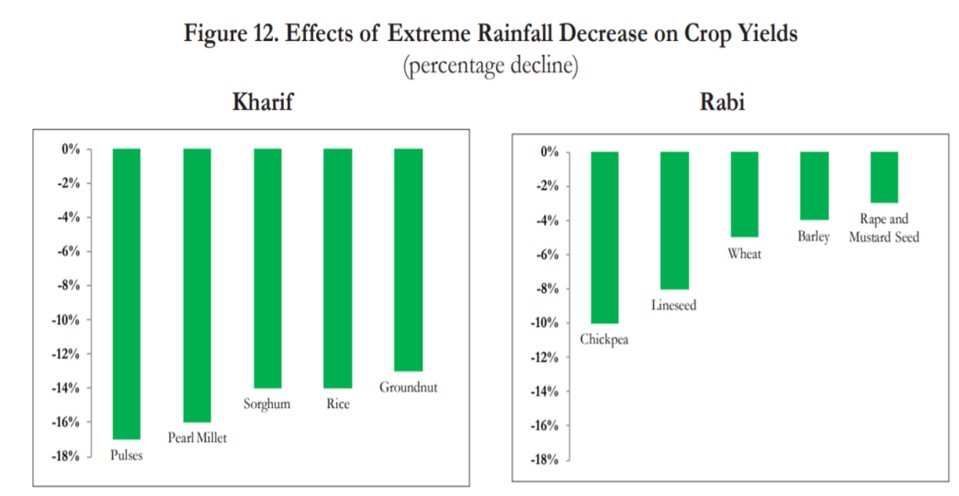
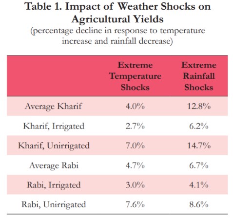
- Impact on Farm Revenue: According to Economic Survey 2017-18, extreme temperature shocks reduce farmer incomes by 4.3% and 4.1% during Kharif and Rabi respectively, whereas extreme rainfall shocks reduce incomes by 13.7% and 5.5% with the largest adverse effects of weather shocks being felt in unirrigated areas.
- Impact on Rainfed Farming: 50-60 percent of Indian agriculture is still rainfed, without access to any form of irrigation. This makes farmers vulnerable to any change in monsoonal patterns; they rely on the rainfall’s arrival date, it’s even spread and consistent quantity. If it is late, seeds fail to sprout and young shoots wither; if the rains come in excess, then the plants drown. By the time the soil dries out, the rains may end, exposing the crops to end-of-season drought.
- Impact on Livestock: Livestock is a major source of income for small and marginal farmers. Both fodder and water for livestock will be impacted if drought conditions extend.
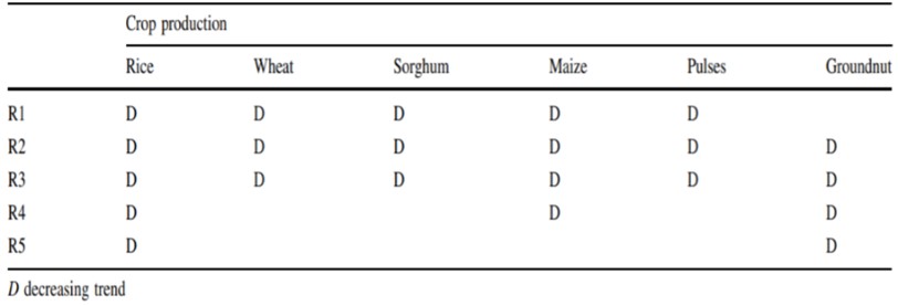
- Regional Analysis of Impact on Agriculture: A study entitled Variability of Monsoon Over Homogeneous Regions of India Using Regional Climate Model and Impact on Crop Production has linked summer monsoon variability and climate change and their impact on crop production across five homogeneous regions –North West India (R1), North Central India (R2), West Peninsular India (R3), Eastern Peninsular India (R4) and Southern Peninsular India (R5). Following pie chart represents the Crop productions and percentage contributions over different homogeneous regions.

Following table depicts the observed trends in various crops production in tandem with the observed monsoon rainfall variability across the five regions during 1986–2010.
Consequences of Stress on Agriculture:
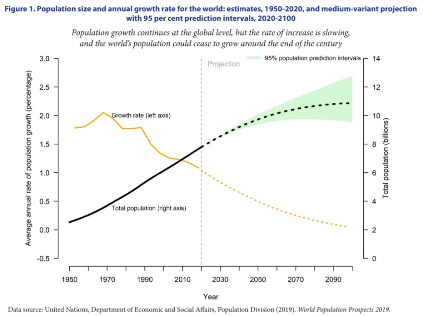
- Food Security challenges: Shifting monsoon trends and patterns are leading to frequent and multiple crop failures. This has implications for food security of the country amid rising population and global warming challenges.
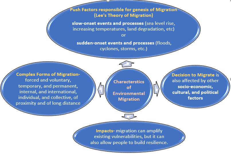
- Migration due to push factors: Extended droughts and extreme floods push farmers and farm labour to migrate to other parts of the country, especially in cities to pick up other jobs or work as construction labour.
- Farmer suicides: Some farmers, who opt not to leave their farms even after repeated crop failures and debts, end their lives in frustration at their own hand. According to latest National Crime Records Bureau (NCRB)data, the suicide rate in the deeply stressed farming sector accounted for 7.4% of the total suicides in the country, resulting in deaths of 5,957 farmers and 4,324 agricultural labourers.
- Impact on Economy: Further, employment in agriculture accounts for close to half the population in India, and 15% of its GDP. Perhaps even more pertinently, the monsoons hold a tight grip on economic development. A poor monsoon causes a declining agriculture sector, food inflation, farmer distress and political agitation.
Way Forward
- India needs to spread irrigation facilities to all parts of country.
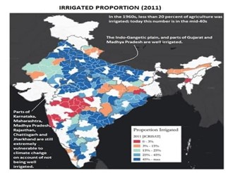
The challenge is that the spread of irrigation will have to occur against a backdrop of extreme groundwater depletion, especially in North India. Technologies of drip irrigation, sprinklers, and water management—captured in the “more crop for every drop” campaign under PMKSY—may well hold the key to future Indian agriculture and hence should be accorded greater priority in resource allocation.
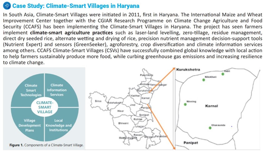
- Crop Insurance: Climate change will increase farmer uncertainty, necessitating effective insurance. Building on the current crop insurance program (Pradhan Mantri FasalBima Yojana), weather-based models and technology (drones for example) need to be used to determine losses and compensate farmers within weeks (Kenya does it in a few days).
- Better availability of institutional credit can help farmers a lot in taking the adverse monsoon impact head on. Despite institutional credit facilities being available for farmers, private moneylenders are a go-to resource for a majority of them — the NABARD All India Rural Financial Inclusion Survey 2016-17 found that 30% of the agricultural households borrow money from non-institutional sources.
- Planning of Agro climatic zones of India: An “Agro-climatic zone” is a land unit in terms of major climates, suitable for a certain range of crops and cultivars. The planning aims at scientific management of regional resources to meet the food, fibre, fodder and fuel wood without adversely affecting the status of natural resources and environment.
- Integrated watershed management approach: This includes comprehensive management of crops, soil, slopes and water drainage etc. This approach will help to sustain prolonged droughts, while also helping to manage the flooding with minimum impacts on crops and livestock. One component may also include diversification of crops to suit the agro climatic zones thus providing natural resistance to crops to weather extremes.
In thinking about agricultural policy reforms in India, it is vital to make a clear distinction between two agricultures in India. There is an agriculture—the well-irrigated, input-addled, and price-and-procurement-supported cereals grown in Northern India—where the challenge is for policy to change the form of the very generous support from prices and subsidies to less damaging support in the form of direct benefit transfers.
Then there is another agriculture (broadly, non-cereals in central, western and southern India) where the problems are very different: inadequate irrigation, continued rain dependence, ineffective procurement, and insufficient investments in research and technology (non-cereals such as pulses, soyabeans, and cotton), high market barriers and weak post-harvest infrastructure (fruits and vegetables), and challenging noneconomic policy (livestock). All this must be comprehensively addressed in wake of impending climate change and shifting monsoon patterns.
Where it can be used?
Paper1: Climatology (Monsoons, climate change), Economic Geography (world agriculture), Regional Planning.
Paper2: Physical setting (mechanism of Indian monsoon), Agriculture, Regional planning and development.
GS: Paper1 (features of world’ geography- monsoon), Paper3 (cropping pattern, irrigation, e-technology in agriculture).
References
- Make a drop count: Southwest monsoon patterns are changing. Implications for farming are huge and worrisome
- Changing Rainfall Pattern in the Country
- How important is monsoon for India's agriculture sector?
- Impact of the monsoon on agriculture will depend on its distribution.
- Mitigating the ‘Make-or-Break’ Role of Monsoon
- How monsoon is linked to agri, economic development?
- Impact on Farm economy
Preparing India for urban acceleration
- In News: Government estimates suggest that over 60 crore people would be residing in urban India by 2030.
- Why India heading toward urban acceleration?
- India's urban areas make a major contribution to the country's economy and host a growing share of the population. As a result urban centres have expanded rapidly as increasing numbers migrate to cities in search of economic opportunity.
- Hence accompanying India's rapid economic growth will be a fundamental shift in terms of a massive urban transformation, possibly the largest national urban transformation of the 21st century.
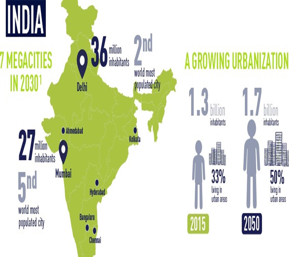
- Why is it important to ensure that this rapid urbanization leads to the development of more economically dynamic, inclusive and sustainable cities?
- Urban areas are hubs of economic growth (Growth Pole) - a Brookings Institute study stated that 123 largest metro cities in the world, with only 13% of the world’s population, contribute 33% of the world GDP. For Example, India's economic powerhouse, Mumbai(as growth pole) not only contributes the highest GDP of $209 billion but is also responsible for 25% of industrial output, 70% of maritime trade in India and 70% of capital transactions to the nation's economy.
- Population density is correlated to innovation: Cities draws in the talent pool from different parts of the nation, leading to greater diffusion of innovation and accelerated economic growth (population of a city doubles, innovation measured by the number of patents marks a rise by 15%).
- Smart Urbanization bring potential of environmental sustainability in lines with “Limits to Growth”: McKinsey study noted that smart cities have the potential to save 25-80 litres of water per person each day, and reduce non-recycled solid waste by 30-130 kg per person annually.
- What are the challenges of accelerating Urbanization in India:
- Poorly planned land uses leading to unrestricted growth to peripheral areas in form of urban sprawl.
- ‘Messy and hidden’ urbanization – According to world Bank Report,2018, settlements have urban like features but not fully equipped to deliver basic services like housing, water etc to the growing number of residents and migrants.
- Public transport provide inadequate service, and non-motorized transit for pedestrians, bicycles, and handcarts is limited, forcing this traffic to compete with cars, trucks and motorcycles for space on the streets.
- Poor management of like side effects (negative externalities) of economic success of cities- Issues of equity, congestion, regional disparities as result of cumulative causation effect of urban growth poles
- Low priority given to Urban resilience mechanism in planning of urban areas in India.
- Solutions to accelerating Indian Urbanization :
- Implement policies for land use and urban planning to avoid excessive sprawl and manage density in cities. For example National Urban Policy Framework, 2018.
- Address infrastructure bottlenecks affecting transport, power, and water, in particular. Find more cost-effective, flexible and sustainable public transport solutions, like Smart Urban Public Transport, for growing cities.
- Effective functional linkages to enable spread development to surround areas and remove regional inequalities, leading to overall regional development of city region.
- As urban areas houses high density of people, jobs and asset and in light of growing climate change related natural disasters, effective investment on urban resilience infrastructure is need of the hour (SDG 11 -Make cities inclusive, safe, resilient and sustainable).
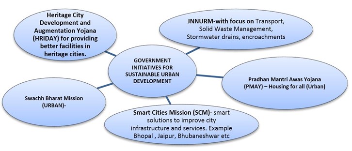
- As the economy advances towards incentivizing wealth creation, environmental sustainability and technologically proficiency, the urbanization acceleration is inevitable. The Budget and the FFC have rightly acknowledged and anticipated the importance of fast-tracking pending urbanization reforms and also building anew for this upcoming reality.
- Where can we use it-
- Paper1- Settlement (urbanization), Regional planning (Growth centres\pole, Regional imbalances, Sustainable development).
- Paper2 -Settlement (urbanization), Regional development and Regional Planning.
Links:
Rural Health Infrastructure
- WHY IN NEWS?
The rising Covid-19 mortality due to shortages of ventilators, oxygen supply has led to refocus on the condition of rural health infrastructure in India.
- State of Rural Health Infrastructure
The Indian rural healthcare system is a three-tier system, comprising Sub-Centre, Primary Healthcare system and Community center.
- Challenges in rural health framework:
- Infrastructural constraints: Rural India has historically had less access to health services. Health facilities in the rural districts are overwhelmed. Shortfall of primary health centres (PHCs) and community health centres(CHC) by 22% and 30% across India, with the highest shortfall in West Bengal, Uttar Pradesh, Bihar, Jharkhand, Rajasthan and Madhya Pradesh. Also there are limitations especially in the context of road connectivity and adequate transport services. Many of the healthcare facilities, public or private are not accessible throughout the year to about a third of the villages due to connectivity infrastructure.
- Human resource shortfalls: There is a critical shortage of medical doctors, paramedical staff, and health workers/Auxiliary Nurse Midwives in large parts of the country. For example, according to Economic Survey 2018-19, at least 60% of PHCs in India have only one doctor while about 5% have none.
- Lack of public investment: Most of the public and also private investment goes into tertiary hospitals, which are almost exclusively located in the urban area. Unfortunately, no such improvement is being seen in the funding towards the NRHM, despite the government’s own National Health Policy 2017 declaring that government expenditure in health will reach 2.5 percent of GDP by 2025.
- Another area of concern in the rural regions is maternal healthcare: Rural women in India face cascading challenges in form of malnutrition, lack of basic sanitization and lack of proper reproductive cares and inaccessibility to treatment for diseases etc contribute to the dearth of healthcare resources available to women in India resulting into low institutional deliveries, high MMR and IMR. For example the north-eastern state of Assam in India has the highest maternal mortality ratio at 229 deaths per 100,000 women.
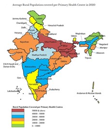
Solution needed to improve accessibility, affordability and availability of health care in rural India:-
- People-centered healthcare: to delivers comprehensive and continuing healthcare of rural populations through preventive and promotive measures.
- Higher investments in healthcare: there is clear evidence that states that spend higher proportions of their budgets on healthcare have better health outcomes than those who spend smaller lesser as reduced public expenditures in primary healthcare will inhibit provision of healthcare to the most marginalized populations.
- IT for Accessible Healthcare Provisioning: information technology can be effectively harnessed to improve the delivery of health services as telecom network is spreading swiftly and the government is keen to provide broadband connectivity to all parts of the country
- High rate of insurance penetration can be effective for health security. To increase this aspect India has come up with Ayushman Bharat Scheme (medical expense coverage up to Rs.5 lakh/family).
- To ensure affordability& accessibility of medical services, schemes like PM Aushadhi Kendra for low cost distribution of medicines through generic medical shops has been launched.

WAY FORWARD:
- Proper training of healthcare professionals is required specially to tackle the women issues.
- Increase India’s budget allocation to healthcare to 5-6% of GDP to lessen the out of pocket expenditure which is as high as 60% of a household’s income.
- The system cannot be upturned in few days but positive efforts be surely made for improvement of rural healthcare.
- Adoption of global practices like Bismarck model of Healthcare system (Insurance based medical services) of Germany, France can be worked upon to improve India’s rural healthcare system.
- Replication of Kerala healthcare model in states like UP, Bihar, Jharkhand, West Bengal, Madhya Pradesh, Rajasthan.
Where it can be used:
Paper1: Regional development and planning.
Paper2: Regional development and planning, rural development programs.
GS: Paper2 (issue relating to development and management of social sectors/services relating to health).
Sources:
- Rural health care needs fixing, and now
- Behind the curve: How COVID-19 exposed India’s apathetic rural health infrastructure
- Challenges to India's Rural Healthcare System in the Context of Covid-19
Jet Streams
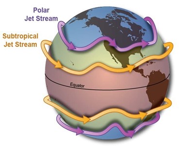
- Jet streams are fast flowing, narrow, meandering air currents existing in mid to upper troposphere and generally blow from west to east all across the globe.
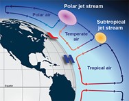
- Earth has four primary jet streams: two polar jet streams, near the north and south poles, and two subtropical jet streams closer to the equator.
- What causes jet streams? When warmer air masses meet cooler air masses, the warmer air rises up while cooler air sinks down to replace the warm air. This movement creates an air current. A jet stream is a type of air current that forms high in the atmosphere.
- Speed: Their speeds usually range from 129 to 225 kmph, but they can reach more than 443 kmph. They are faster in Winter when the temperature differences between tropical, temperate, and polar air currents are greater.
- Significance: They provide a potent tailwind to a flight travelling from west to east which helps in reducing travel time and fuel consumption, they can transport weather systems across the world affecting temperature and precipitation, also they can help meteorologists determine where weather systems will move next.
- They are also impacted by El Nino and La Nina. During El Nino for example, precipitation usually increases in California because the polar jet stream moves farther south and brings more storms with it.
Sources:
Garden Cities
- A garden city is a planned town of limited size with broad streets and spacious layout, containing trees and open spaces and surrounded by a rural belt
- It is the ideal of a planned residential community, as devised by the English town planner Ebenezer Howard in 1898.
- It was proposed in response to the need for improvement in the quality of urban life, which had become marred by overcrowding and congestion due to uncontrolled growth since the Industrial Revolution.
- It is a model of urban planning based on the creation of small cities That would combine the advantages of both urban and rural environments.
- A garden city contains specific utopian elements like small communities Planned on a concentric pattern that would accommodate housing, industry and agriculture, surrounded by green belts that would limit their growth.
- Cities like Letchworth, Welwyn, and Stockfeld in England, were built using the concept of garden cities.
- This concept is still frequently revisited to this day - albeit considerably different from the original idea - to propose urban planning solutions that attempt, at least in theory, greater integration between urban areas and green spaces.

Sources:
Bolson and Playas
- Bolsons are the intermontane basins in arid or semiarid areas.
- It is widely used in the southwestern United States and northern Mexico to refer to a depression that have centripetal drainage entirely surrounded by hills or mountains.
- These basins are characterised by 3 distinct landform features: Pediments; Playas and Bajadas.
- Playas are the lowest part of a bolson which is also known as salt pan.
- The water collected in the centre of the bolson form temporary lakes which are called as playas.
- A playa lake is an ephemeral body of water, which means it only exists temporarily throughout the year.
- They are locally known as Khabari and Mamlaha in Arabian deserts and Shatts in Sahara.
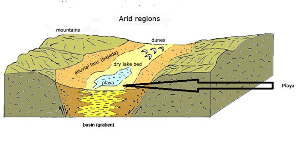
FIG: Playa formation in Arid Region
Souces:
Tidal Bore
- According to Thurman & Trujillo, tidal bore (Bore = Crest or Wave) is a wall of water that moves up certain low lying rivers due to an incoming tide.
- Since it is a wave created by the tides, it may be considered to be true tidal wave.
- The conditions conducive for the occurrence of tidal bore are as follows:
- Narrow & low-lying coastal river with gentle channel gradient.
- A bay with narrow opening & tapering head.
- Large tidal range (wave height), usually more than 5 meters.
- Upward decreasing water-depth, meaning thereby decreasing depth of water in upriver section.
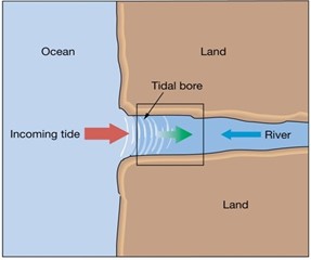
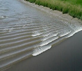
- The estuary of the Chientang river of China is known to have the highest tidal bore, measuring more than 8 meters in height, in the world.
- Tidal Bores also occur in Hooghly river of India.
Source:
Smart Sustainable City: Singapore
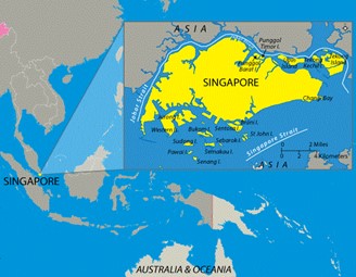
Singapore, an island city-state is resource-constrained, and imports most of its food, water, and natural resources. It also faces many issues related to climate change, population density, and changes in its resident’s demographics. Despite all these challenges, Singapore had grown into a smart sustainable city using advantages of ICTs (Information & Communication Technologies) and topped the 2020 Smart City Index (SCI) released by IMD business school.
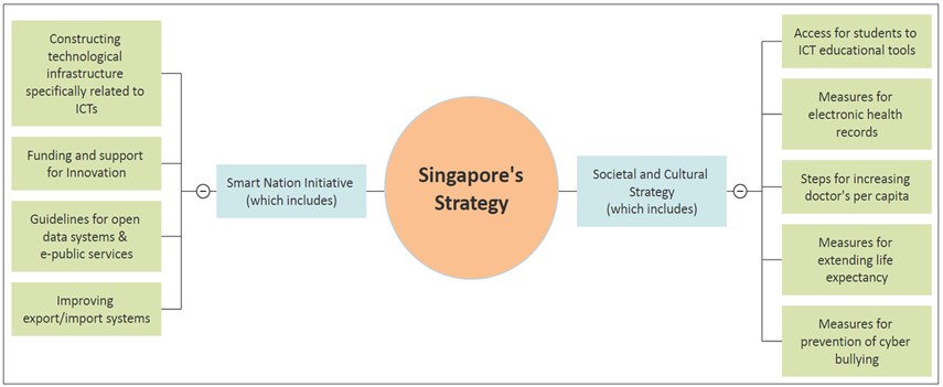
Singapore also adopted several environmental measures which includes:
- Installing adequate water saving and drainage systems in homes.
- Increasing renewables in the energy mix.
- Developing air quality monitoring
- Transport related: Carbon emission based vehicle scheme, Integrated public transport systems consisting of mass rapid transit system.
- Promoting energy efficiency and green buildings.
- Innovative technologies to recycle and reduce waste.
- (E.g. Waste to energy incineration plants, Zero food waste campaign)
This can be replicated for Indian cities too, which suffered a significant drop in the 2020 Global smart city index. (None of the Indian cities were in top 50).
Where it can be used?
This case study can be used in topics related to: Paper 1 (Sustainable Development, Climate Change, and Regional Planning), Paper 2 (Urban area development, Smart Cities, Sustainable Cities, and Conservation of Natural Resources).
Sources:
Advantages Agro (Argan farming)- Sylvo (trees)- Pastoral (goats) system
- Why in news: United Nations has designated 10 May as the International Day of Argania, to recognize this valuable resource and the local communities that process and farm it.
- Background: The Chtouka Ait Baha, Morocco (Africa) region, is one of the 62 innovative GIAHS sites and the traditional communities of the region are celebrated worldwide whose innovative argan farming techniques increase resilience to climate change and boost food security.
- A GIAHS is a living, evolving system of human communities in an intricate relationship with their territory, cultural or agricultural landscape or biophysical and wider social environment.
- Challenges of the region:
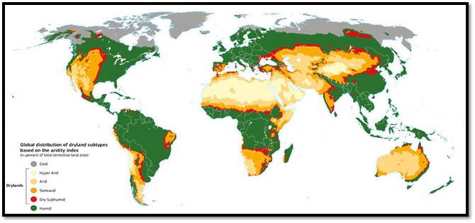
- Arid and semi-arid lands, desert mountain-scape not suitable for agriculture.
- Morocco'srural areas have poor socio-economic infrastructure, low levels of education and an ageing farmer population.
- Small farmers are economically vulnerable, particularly to climate change related issues.
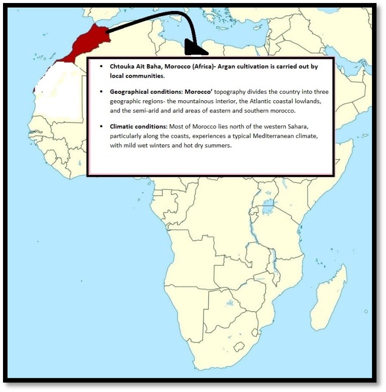
- How integrated Argan cultivation is helping to overcome above challenges: Local communities have developed many ways of using the land, including agro-forestry practices that are highly resilient to the arid, water-scarce environment and poor soils:
- can withstand temperatures of up to 50 degrees- drought- and heat-resistant and thus Argan trees are the pillar of this traditional agricultural system, providing most of the farmers’ income.
- A key role in the ecological stability as with more than 50 cultivated plant species and 102 local varieties and local breeds of cows, sheep, goats, camel, equines, poultry and honey bees, livelihoods of local communities are tightly linked to this biodiversity of the region.
- Water conservation: Agro-pastoralists have carved large rain-water reservoirs, called Matifiya, into rock underneath the ground-effective at collecting.
- Social benefits: Empowerment of rural women, as most farmers are women.
- These local area based development practices can be replicated in drier regions of the world and India like plateau interiors, central hill region, western region etc.
- Where can we use it:
- Paper1: Climatology (climate change), Economic geography (food security).
- Paper2: Agriculture (agro climatic regionalization, planning).
- Tags: UPSC, Geography, Optional, Case Study, Argan Farming, Sylvo-Pastoral systems, Morocco.
Links :
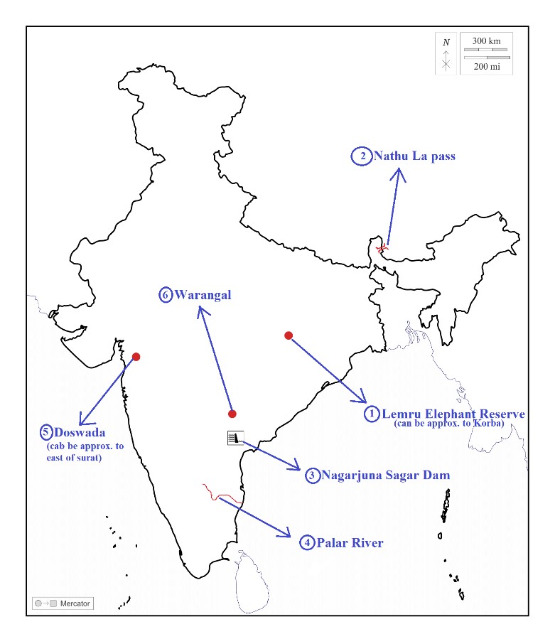
Places in news - Lemru Elephant Reserve
|
Lemru Elephant Reserve:
|
|
Nathu La Pass:
|
|
Nagarjuna Sagar Dam:
|
|
Palar River:
|
|
Doswada:
|
|
Warangal:
|
Share the article
Get Latest Updates on Offers, Event dates, and free Mentorship sessions.

Get in touch with our Expert Academic Counsellors 👋
FAQs
Geography Current Affairs focuses on the contemporary issues, events, and developments in the field of geography. It covers recent geographical phenomena, environmental changes, geopolitical shifts, and related news. This differs from regular geography studies which may focus more on foundational concepts, historical contexts, and theoretical frameworks.
Updates are provided regularly to ensure that subscribers stay informed about the latest developments in geography. Typically, updates are provided on a fortnightly basis, depending on the frequency of significant events and changes in the field.
Absolutely. Geography Current Affairs serves as a valuable resource not only for Geography optional but also for GS papers, especially GS Paper 1 (covering Indian Heritage and Culture, History, and Geography of the World and Society) and GS Paper 3 (covering Technology, Economic Development, Biodiversity, Environment, Security, and Disaster Management). It aids in building a holistic understanding of various topics and strengthens answer-writing skills by incorporating contemporary examples and perspectives.
Geography Current Affairs holds immense importance for UPSC preparation, particularly for aspirants opting for Geography optional. It helps candidates stay updated with the latest developments, geographical phenomena, environmental issues, and geopolitical shifts worldwide, aligning them with the dynamic nature of the subject as tested in the UPSC examinations.

