19 Jun
Arabian Sea Cyclones
In News
A study by India Meteorological Department (IMD) in 2021 stated that there is an increasing trend in the tropical cyclone’s frequency over Arabian Sea, making the coastal regions highly vulnerable.
Cyclones in Arabian Sea – Historical Trends
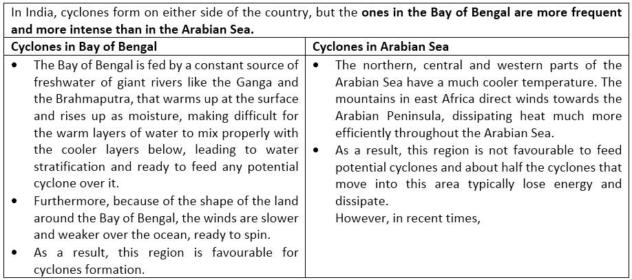
- Historically, the Arabian Sea averaged two or three cyclones, that were typically weak, in a year. The average ratio of cyclone in Arabian sea to that of Bay of Bengal stands at 1:4.
- Between 1891 and 2000, 48 tropical cyclones impacted the west coast, of which 24 were severe cyclonic storms, while about 308 cyclones, including 103 severe cyclonic storms, impacted the east coast of the country from the Bay of Bengal.
- Cyclones occur in the pre-monsoon months of May-June and the post-monsoon months of October-November. Formation of cyclonic storms in the Arabian Sea is normal in pre- monsoon months but it is rare if it develops in October-November. Usually, the Bay of Bengal witnesses cyclonic storms during this period.
Current Trends of Cyclones in Arabian Sea
- There is an emergence of new trends in cyclonic activities in Arabian Sea – in respect of frequency and also the timing of cyclones. The sea surface temperatures (SST) continue to remain abnormally high, in the 30°, feeding cyclonic conditions
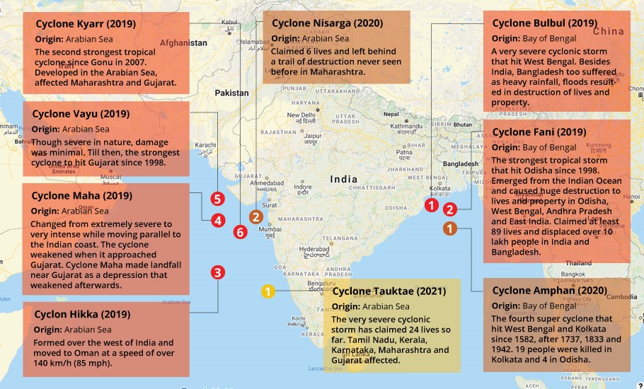
- Since 1980, this is the first time in 2021 that the Arabian Sea has seen pre- monsoon cyclones four years in a row.
- The 2021 is also the third consecutive year when a cyclone has come so very close to the west coast of India.
- In 2018, while the Bay of Bengal maintained its average of four cyclones a year, Arabian Sea gave rise to three instead of one. Later in 2019, Arabian Sea saw five cyclones.Overall, there was a 32% rise in the number of cyclones between 2014 and 2019.
- Additionally, cyclones over the Arabian Sea are also increasing in intensity. Typically, an extremely severe cyclone occurs once every four to five years here. Between 1998 and 2013, only five extremely severe cyclones occurred in Arabian Sea.
- IMD has confirmed that Tauktae was the fifth-strongest storm in the Arabian Sea since 1998 and the strongest pre- monsoon cyclone since 2010.
- Also, the frequency of intense/severe cyclonic storms increased in the post-monsoon period over the Arabian Sea. 2014 saw Cyclone Nilofar and 2015 saw Chapal and Megh, all of which occurred in October and November.
Reasons for Increasing frequency of cyclones in Arabian Sea
- TheClimate Change and Global Warming:Changing trends of cyclones are consistent with rising temperatures in the Indian Ocean. As the cyclones draw their energy mainly from ocean heat, the warmer the sea is, higher are the chances of cyclones. Climate scientist Hiroyuki Murakami in his study found that 64% of cyclones in the Arabian Sea in recent years were caused by climate change.
- A 2014 study found that in last 4 decades while thetemperature of the Indian Ocean rose overall by 0.7 degrees Celsius, the generally colder western Indian Ocean experienced an unexpected warming of 1.2 degrees Celsius in the summer.
- The IMD has noted that the surface temperature of Arabian Sea is abnormally high right now, at 30-31 degree Celsius especially in the section around Goa -Lakshadweep. Tauktae originated in the same region.
- Indian Ocean Dipole (IOD): A positive IOD means warming of the west Indian Ocean and Arabian Sea. This helps formation of a low-pressure area. The positive IOD also negates the effect of the El Nino. E.g., 2019 recorded the formation of 5 cyclones in Arabian Sea which also happened to be the year of strongest ever positive IOD till then.
Other factors influencing frequency of cyclones in Arabian Sea
- Teleconnections: A study conducted by the National Institute of Oceanography, Goa, suggests

Why have the frequency of intense/severe cyclonic storms increased in the post-monsoon period over the Arabian Sea?
Severe storms typically occur during spring. However, the three severe cyclones (Nilofar, Chapal and Megh) all hit in October and November. Also, in 2019, cyclones Kyarr,Mahaand,Pawan brewed in the Arabian Sea in post-monsoon period.
Regarding the increase in extremely severe cyclonic storms (ESCSs) during the post-monsoon season, scientist have found three factors which may be related.
- Rising SST, linked to anthropogenic warming, natural variability, or stochastic behavior, coupled with climate change impact over the Arabian Sea, contribute to intensifying cyclones, leading to more severe storms in the Arabian Sea.
- The second factor is that onset of winter monsoon is delaying, leading to a longer storm season.
- The last factor is increase in anthropogenic aerosols, especially after kharif harvest on India peninsular during post-monsoon season, leading to changes in SST distribution, resulting in more active storms.

Challenges posed by rising frequency of cyclones in Arabian Sea
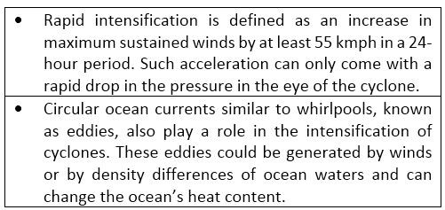
- Rapid Intensification: Ocean warming has introduced some new challenges. Cyclones are now intensifying rapidly since warm ocean waters act as fuel for them. For instance, Cyclone Tauktae intensified from a depression to severe cyclone in two days which is a new record. Previously, cyclones took four-five days.
- This kind of rapid intensification gives us less time to take immediate measures for evacuation at the ground. State-of-the-art cyclone models are unable to pick this rapid intensification because they do not incorporate the ocean dynamics accurately. This is hence a forecasting challenge that we need to include in disaster management cycle.
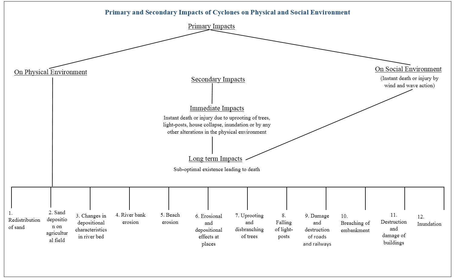
- Cyclone led Internal Displacements, in form of climatic refugees,prompted by increased hazard intensity, high population and soci0-economic vulnerability of coastal communities. For ex: Cyclone Amphan triggered more than 4 million evacuations in the states of West Bengal and Odisha.
- Destruction of natural ecosystems and Biodiversity loss due to significant erosion of shores and beaches.
- Also Cyclonesin coastal areas severely affect all the components of agriculture sector through direct damage by high speed wind, torrential rain, extensive flooding, saline water intrusion and sand mass making the fields unsuitable for agriculture, threatening food security of the region.
Conclusion
Climate projections indicate that the Arabian Sea will continue warming due to increasing carbon emissions, resulting in more intense cyclones in the future. Considering that both cyclones and floods due to heavy rains are increasing across the west coast along with a gradual rise in sea level, there is need preparedness and risk reduction.
Global warming has presented us with new challenges such as rapid intensification of cyclones, which need to be closely monitored at higher resolution and accuracy using on-site platforms such as buoys and moorings. Improving the Indian Ocean Observing System (IndOOS) and incorporating the global warming signals in the weather models can help us tackle the challenges of intense cyclones in the future.
With the data that we have collected, and our weather and climate models, it is possible to understand how the cyclones might change in the coming decades and how that might impact the coastline of India. A risk assessment based on this can definitely help save lives and property.
Where we can use it: Paper1 - Climatology (Climate change), oceanography, Environment (environmental management) Paper2- physical setting, contemporary (hazard management).
References:
- ‘Arabian Sea to get more severe cyclones’: Expert
- Tropical cyclones in the Arabian Sea: Why are they increasing?
- What Cyclone Tauktae tells us about Arabian Sea
- Cyclones over Arabian Sea more frequent: IMD study
- Tauktae rare, but Arabian Sea to see more cyclones than Bay of Bengal
- More cyclones now storming India’s coastlines, Arabian Sea in turmoil
- Tauktae: How Arabian Sea has become a hotbed of cyclones
- Is Cyclone Tauktae an indication towards a new trend for Arabian Sea?
- Why Is Arabian Sea Transforming Into Fresh Cyclone Hotbed?
- Increasing Frequency of Extremely Severe Cyclonic Storms over the Arabian Sea
- Cyclones over Arabian Sea on the rise due to global warming
- Is the Arabian Sea no longer pacific?
- Growing Western Threat: Why Frequency of Cyclonic Storms is Rising Sharply Over Arabian Sea
- Cyclone Tauktae shows why north Indian Ocean is now whacky
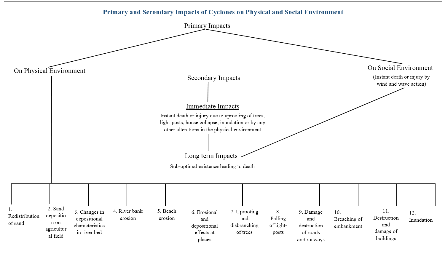
- IMPACTS OF CYCLONES
Himalayan Glacier Melt, Curbing Air Pollution is Key
In News: World Bank report titled “Glaciers of the Himalayas: Climate Change, Black Carbon and Regional Resilience” has reported that Black carbon deposits are compounding the effects of climate change to speed up the melting of the Himalayan glaciers.
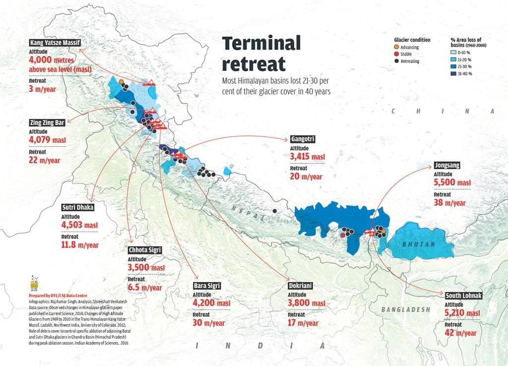
- Various Causes of melting glaciers in Himalayas:
- Changing temperatures and precipitation patterns due to climate change. For example the annual mean surface-air-temperature in the HKH increased at a rate of about 0.1 °C per decade during 1901–2014, with a faster rate of warming of about 0.2 °C per decade during 1951–2014, which is attributable to anthropogenic climate change.
- Black carbon deposits – air-borne particles generated by incomplete combustion from brick kilns, diesel exhaust are accelerating glacier and snow melt in these ranges.
- Both, India and China are the largest emitters of black carbon in the world.
- The Indo-Gangetic plains will become the largest contributor of black carbon.
- Brown Carbon deposit released by the combustion of organic matter leading to rapid melting.
- Business-as-usual practices, such as agricultural burning in western India and forest fires along the Himalayan slopes, would further speed glacier melt, with harmful implications for the health and well-being of people in the region.
- Consequences of melting glaciers:
- Increases the risk of runoffs and floods as recently seen with the Chamoli, Uttarakhand glacier disaster.
- Melting glaciers increases number of glacier lakes at the mouth or snout of the glacier. These lakes also become reservoirs of ice and moraine debris. The breach of glacier lakes poses a severe threat to the community in form of “Glacial lake outburst flood” (GLOF). Such intense inundation will not only damage the environment, but also force the regional residents to migrate southward.
- Once the flooding phases out, droughts will set in due to the disappearance of the water source, which could further pose severe challenges to water and food security in the local and downstream region. For example melting of Gangotri Glacier in the Uttarkashi District of Uttarakhand.
- Way forward to curb black carbon emission and to slow Himalayan glacier melt:
- Ecological restoration of Himalayan ecosystem is the need of the hour.
- Economically and technically feasible policies –alternates to stubble burning, enhancing fuel-efficiency standards, phasing out diesel vehicles and promoting electric cars etc.
- Improving the efficiency of brick kilns, which account for roughly half of black carbon emissions, would reduce melt-accelerating deposits, and modest up-front investments that would quickly pay off are available
- Cleaner cook stoves and cleaner fuels are another key way to reduce black carbon emissions. Incentivizing households to switch from biomass or coal to liquefied petroleum gas (LPG) and to solar energy could achieve this.
- Regional cooperation to protect these resources as fully addressing the challenges associated with the melting glaciers of the Himalayas is a trans-boundary task that goes beyond the scope of a single country’s policymakers. For example : Afghanistan, Bhutan, India, Nepal, and Pakistan launched a regional network in 2018 to boost their mountain economies and combat glacier and snow melt caused by climate change and air pollution across the region.
- Other reports highlighting the issue:
- Intergovernmental Panel on Climate Change (IPCC) 2019 Report .
- The Hindu Kush Himalaya Assessment Report, coordinated by the International Centre for Integrated Mountain Development (ICIMOD).
- Where can we use it : Paper1(Climate change and Environmental geography) and paper 2(Contemporary, Agriculture and Resources)
Sources:
- To Slow Himalayan Glacier Melt, Curbing Air Pollution is Key
- Black carbon is a threat to Himalayan glaciers
- Assam: Experts laud creation of separate department on climate change
ECOSYSTEM RESTORATION
- In News: The theme for World Environment Day 2021 was 'Ecosystem Restoration' and 2021-30 declared as “Decade on Ecosystem Restoration”.
- Meaning: Ecosystem restoration means preventing, halting, and reversing the damage done to nature. It calls for assisting in the recovery of ecosystems that have been degraded or destroyed, as well as conserving the ecosystems that are still intact.
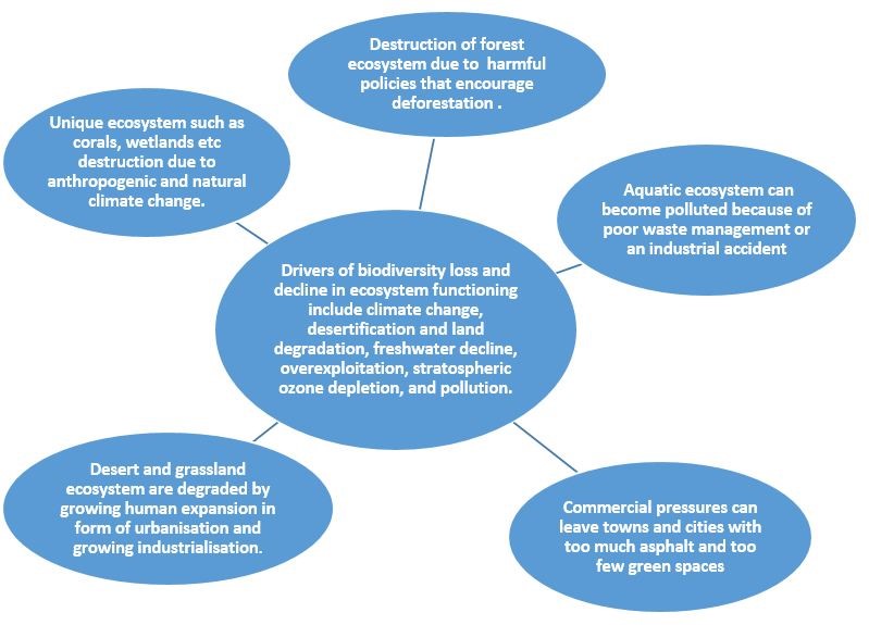
- Need for ecosystem restoration:
- Restoration of ecosystem holds significance in a globalised world that has been witnessing rapid development at blinding speed.
Example: “As much as 50% of our coral reefs have already been lost and up to 90% of coral reefs could be lost by 2050, even if global warming is limited to an increase of 1.5°C,” the UN has warned.
- The loss of ecosystem deprives the world of carbon sinks, like forests and peatland. Emission of global greenhouse gasses have grown exponentially for three years in a row and the blue planet is a step ahead in its path to potentially catastrophic climate change. Restoration could also remove 13 to 26 gigatons of greenhouse gases from the atmosphere.
- The shrinking area of natural habitat for animals has led to ideal conditions for pathogens – including corona-viruses – to spread. It is important if we are to mitigate the extent of the ecological crisis that we are currently facing, and protect the biodiversity for future generations.
- Our food systems and the revival of forest and agrarian crops depend on healthy soils. Therefore, the restoration of soil is important to sustain life on earth.
- Ecological restoration can help to sustain the diversity of human cultures by supporting mutually advantageous relationships between human beings and the nature.
- The economic benefits of such interventions exceed nine times the cost of investment, whereas inaction is at least three times more costly than ecosystem restoration.
- For instance : Between now and 2030, the restoration of 350 million hectares of degraded terrestrial and aquatic ecosystems could generate US$9 trillion in ecosystem services
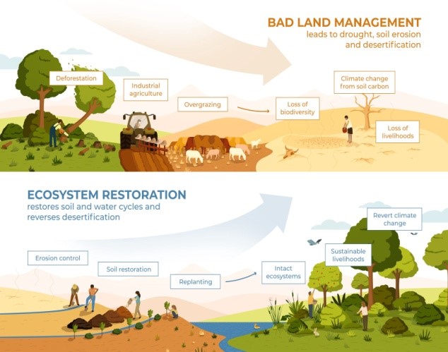
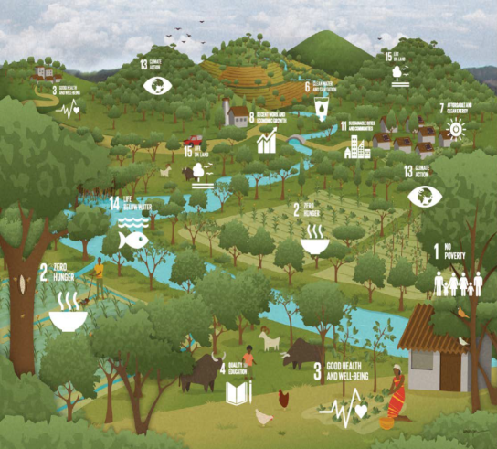
- Restoration can help us achieve all of the Sustainable Development Goals. Without reviving ecosystems, we cannot achieve the Sustainable Development Goals or the Paris Climate Agreement.
- Steps taken :
- #GenerationRestoration, a global movement and practical guide by UN to restore ecosystems everywhere for the good of people and nature.
- Ecosystem restoration is recognized as a key component in achieving targets under existing international conventions and agreements. These include
- the 2030 Agenda for Sustainable Development-the Sustainable Development Goals (SDGs)
- the Strategic Plan for Biodiversity 2020 and its Aichi Biodiversity Targets,
- the Unite Nation Framework Convention on Climate Change and Paris Agreement,
- the United Nations Convention to Combat Desertification and its target of Land Degradation Neutrality,
- the Ramsar convention, and the United Nations Strategic Plan on Forests 2017.
- India’ ecosystem restoration initiatives:
- National Afforestation Programme and CAMPA
- Green skill development programme
- National Coastal Management Programme
- National Mission on Himalayan Studies under Climate Change programme
- National Biodiversity Action plan
- National Mission for Green India
- Adoption of 3R policy (Reduce, Reuse, Recycle) for resource efficiency and complimentary benefits ecosystem restoration.
- Examples of Ecosystem Restoration:
- Wetland Chilika lake, Odisha: Restoration project aimed to protect the lake’s ecosystem and biodiversity, mitigate the conflicts, and restore the lake by developing a proposal for integrated resource management around the lake and became first wetland from Asia to be removed from Montreux record.
- Zoological Survey of India and Gujarat Forest department drive to restore corals in gulf of kachchh using biorock or mineral accretion technology.
- In 2014, Arunachal Pradesh Environment and Forest Department has achieved 70 percent afforestation in the state at a time when forest areas are decreasing alarmingly in the country.
- Ecosystems are also complex and highly varied, and their restoration needs careful planning and patient implementation.
- Where can we use it:
- GS: PIII (Conservation, Environmental Pollution and Degradation, Environmental Impact Assessment).
- Geography: P1(Biogeography and Environment) and P2(Resources).
Sources:
- NGT chief calls out authorities, citizens for restoration of ecosystem on World Environment Day
- Development partnerships for ecosystem restoration: A new challenge on World Environment Day
- ECOSYSTEM RESTORATION PLAYBOOK
- WHAT IS ECOSYSTEM RESTORATION?
- World Environment Day 2021: Why restoration of ecosystem is important
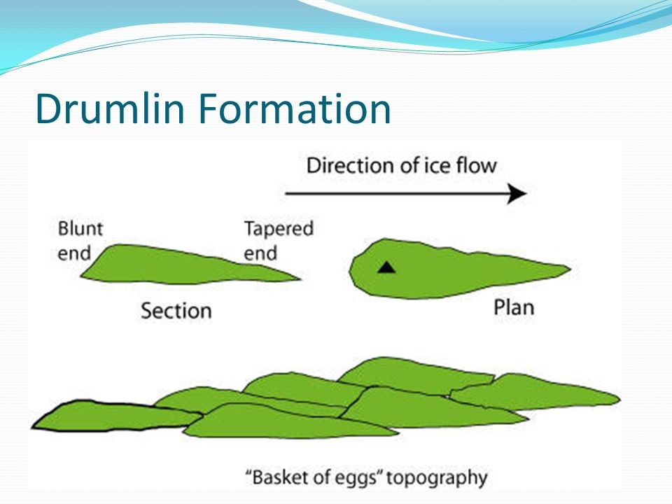
Basket of eggs topography
The swarm of rounded hummocks resulting from the deposition of glacial till, which are elliptical or ovoid hills, blunt on the upglacier end with an elongated downglacial tail, typically known as Drumlins. Usually, these occur in cluster and regular pattern known as basket of eggs topography.
Miyawaki
Miyawaki is a technique pioneered by Japanese botanist Akira Miyawaki, that helps build dense, native forests in a short time.
- This method includes planting trees (only native species)as close as possible in the same area which not only saves space, but the planted saplings also support each other in growth and block sunlight reaching the ground, thereby preventing the growth of weed.
- The approach is supposed to ensure thatplant growth is 10 times faster and the resulting plantation is 30 times denser than usual.
- Such forests lack some qualities of natural forests, such as medicinalproperties and the ability to bring rain.
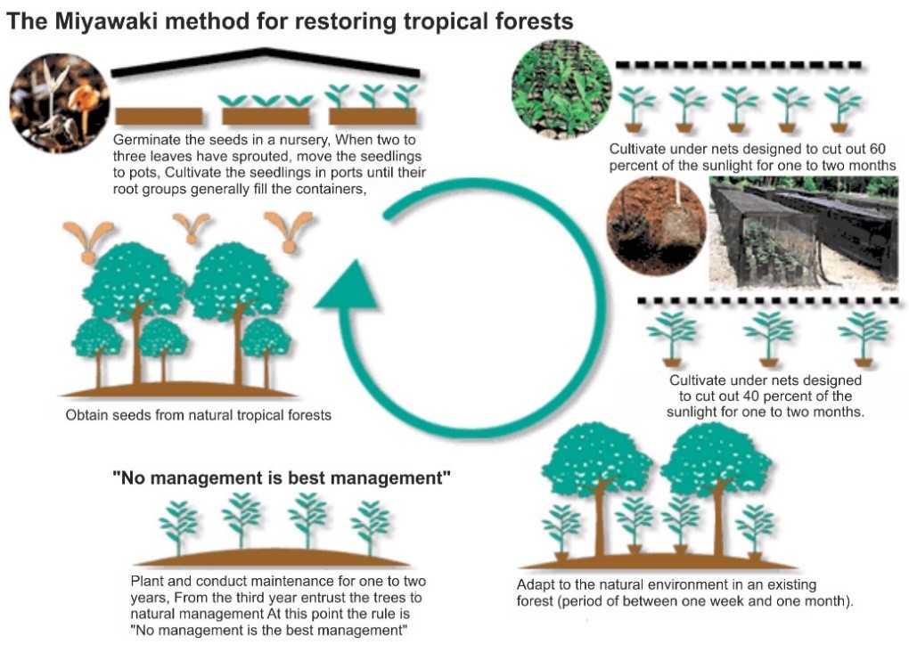
Telangana government has introduced the Japanese “Miyawaki” method of afforestation to grow urban forests and expand the green cover as well as to meet the stipulated plantation target under the Telanganaku Haritha Haaram (TKHH).
Areal differentiation (Richard Hartshorne)
It focused on the description of particular places and areas as unique identities. It is a process by which geographers construct regions to describe and interpret the differences in the difference areas of earth surface. It was first conceived as idiographic (regional geography) but recently analysis of regional differentiation have been reinstated as a central focus of modern human geography as part of the attempt to interpret and understand how regional disparities occur.
Mental map
A mental map, also known as geographies of mind, is a representation of the spatial form of the phenomenal environment which an individual carries in his/her mind.
These mental maps were part of Primary paradigm of M-E relationship in which man is depicted as mediated by mental processes and cognitive representation of external environment. The representation is of the individual’ subjective image of place and not only includes knowledge of features and spatial relationships but also reflects the individual’s preference for and attitude towards places.
Such mental maps are derived via environmental perception (the cognitive mapping process comprise a series of pshychological transformation by which an individual obtain, codes, stores, recall and decode information about the relative location and its attributes).
The product of this process is a mental or cognitive map and can be shown categorically as a perception surface.
Scud Cloud
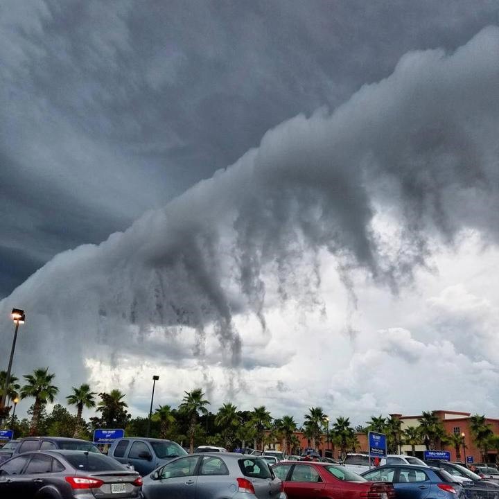
SCUD is an acronym standing for “Scattered Cumulus Under Deck”.
Scud clouds are low, ragged and wind-torn cloud fragments, usually not attached to the thunderstorm base. They are often seen in association with, and behind, gust fronts.
Scud clouds DO NOT produce severe weather. Scud clouds are often mistaken for wall clouds and tornadoes, especially when attached to the thunderstorm base.
A way to differentiate scud clouds from wall clouds is to watch their relative position with respect to the rain area: scud clouds move away from the rain area while wall clouds maintain the same relative distance.
THE MEDITERRANEAN: A BIODIVERSITY UNDER THREAT
WHY IN NEWS?
- Recently France Naval ships were trying to minimize the flow of oil in Mediterranean sea to reach the coast of Corsica. France has closed the beach of Corsica for any human activities.
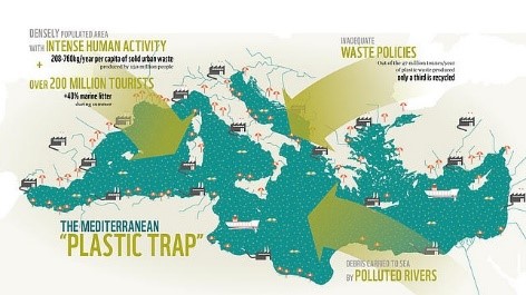
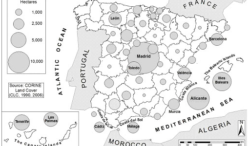
Source:-WWF
About Mediterranean Biodiversity Region
The Mediterranean Basin is one of the
world’s richest places in terms of animal
and plant diversity
- The Mediterranean region has about 25,000 species of plants & this gave recognition as one of the first 25 Global Biodiversity Hotspots.
- Although the Mediterranean Sea makes up less than 1% of the global ocean surface, it comprises 18% of the world’s macroscopic marine species and high endemism of amphibians in the region.
UNSUSTAINABLE COASTAL DEVELOPMENT
- over 56%
- of endemic freshwater fi sh species are
- threatened with exti
This has led to the
Mediterranean being recognized as one
of the fi rst 25 Global Biodiversity Hotspots
Measures Taken
- Conservation actions applied to date have had positive results like some species have already been saved from
- To counter the problems of urban sprawl, the compact city development has been planned in the region.
- The study of flora & fauna has also been planned to check the status of the marine species.
- Following the ecological principle of sustainable life, the region has worked on Area Based Conservation
- Financial instruments like Critical Ecosystem Partnership Fund (CEPF) has invested US$ 10 million for conservation of Mediterranean
The article can be used for-Urban Sprawl, Marine pollution, Environmental Degradation, Biodiversity loss
Sources:
- Urban Sprawl and Northern European Residential Tourism in the Spanish Mediterranean Coast
- The Mediterranean: a biodiversity hotspot under threat
- Mediterranean Sea oil spill approaches Corsica's east coast
Champu Khangpok: Floating Village in Manipur
WHY IN NEWS?
In November 2020, the Election Commission of India recognised the existence of Champu Khangpok- Loktak’s floating village and set up a polling booth in the village (it was removed from electoral records in1980)
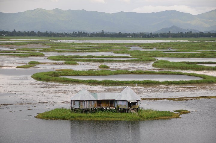
Problems for the Champu Khangpok
- Livelihood based on Phumdis
- Phumdis—thick mats of aquatic and terrestrial vegetation floats with the wind & accommodate huts.
- Due to its decaying, people are losing their home and also source of edibles.
- Exploitation by the money-lenders
- The nation-wide lockdown has hampered the agri-income of the region, leading to debt trap with Unja-local money lender.
- Loss to wetland
- The Loktak lake was a group of wetlands and spot for migratory birds.
- Due to Ithai barrage formation(1983) the outlet for the wetland was closed & thus turning into a lake.
- Loss of fisheries
- Fishing being the sole income-earning medium in the region has deteriorated.
- Due to building of Ithai barrage fishes are not coming to Loktak lake from Manipur river system.
WAY FORWARD
- "There is an urgent need for the government to provide Champu khangpok, financial assistance and other welfare benefits, particularly during the lean season when catch dwindles.
- The government can think upon decommissioning of Ithai dam for preservation of the natural ecosystem.
- Provision should be made for basic amenities like solar lighting, safe drinking water, potable toilets, primary healthcare and education, and Champu Khangpok should be developed as a model Fishing village in line with concepts of a Green village".
Where this article can be used- Regional Planning, TADP, Loss of Biodiversity, North-East development
& Hill Area Development.
Source:
PLACES IN NEWS
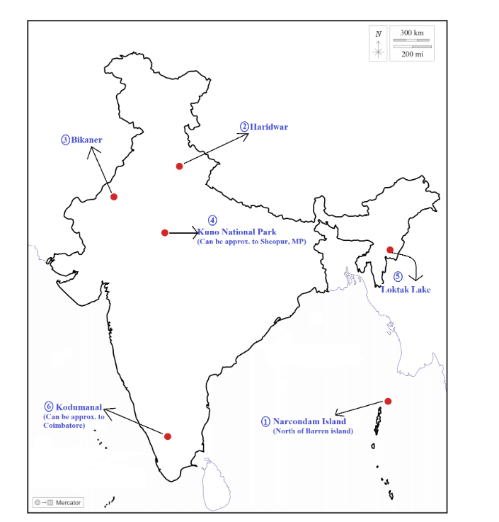
1.Narcondam Island:
• Why in news: Zoological Survey of India (ZSI) has discovered a new species of insectivorous mammal, a white- toothed shrew, from Narcondam Island of the Andaman and Nicobar group of Islands.
• Island is home to six tribal groups consisting of the Great Andamanese, the Jarawa, the Onge, the Shompen, the Sentinelese, and the Nicobarese.
• India's easternmost Island, a small volcanic island, classified as a dormant volcano by the Geological Survey of India, located in the northern Andaman Sea.
• Narcondam Island Wildlife Sanctuary is notified as a protected reserve by the government of India to protect and monitor the Narcondam hornbill.
• It is also an important Bird Area and listed on the UNESCO tentative Lists of World Heritage Sites.
2.Haridwar:
• Why in News: The recent HaridwarKumbhMela turned out to be a super spreader event in the wake of 2nd wave of COVID-19 infections.
• Haridwar is a city in Haridwar district of Uttarakhand.
• The city is situated on the right bank of the Ganga River, at the foothills of the Shivalik ranges.
• The climate is temperate in Haridwar and Rainfall is due to Monsoons and Western Disturbances.
• It’s a major pilgrimage center.
3.Bikaner:
• Why in news: The wool market of Bikaner, Rajasthan has been reeling under severe crisis over the years, primarily due to the increased use of synthetic wool and imports from countries like China and Australia.
• Bikaner is a district of Rajasthan.
• Bikaner is situated in the middle of the Thar Desert and has a hot desert climate (Köppen climate classification BWh) with very little rainfall and extreme temperatures.
• Mostly arid and desert soils with very less or no vegetation.
• Jorbeer conservation reserve, Bikaner is host to nearly 1300 migratory vultures.
4.Kuno National Park:
• Why in news: Kuno national park to get eight cheetahs from Africa under India’s first inter-country big cat relocation project.
• Kuno National Park is a protected area in Madhya Pradesh that received the status of national park in 2018. ( sheopur and morena districts)
• It is part of the Khathiar-Gir dry deciduous forests ecoregion.
• The sanctuary has a vast richness and diversity of indigenous flora and fauna which represents a typical cross-section of the dry deciduous forest of the Central India.
5.Loktak Lake:
• Why in News: Loktak Lake’s only floating village is sinking under COVID-19 induced financial crisis.
• It is located in the state of Manipur.
• It is the largest freshwater lake in Northeast India and is famous for the phumdis (heterogeneous mass of vegetation, soil, and organic matter at various stages of decomposition) floating over it.
• KeibulLamjao is the only floating national park in the world which is on this lake.
6.Kodumanal, Tamil Nadu-
• Why in news: Recently, the State Department of Archaeology, Chennai has excavated Megalith Burials which reveals megalithic belief in afterlife.
• It is village located in the Erode district in the southern Indian state of Tamil Nadu.It was once a flourishing ancient trade city known as Kodumanam, as inscribed in Patittrupathu of Sangam Literature.
Share the article
Get Latest Updates on Offers, Event dates, and free Mentorship sessions.

Get in touch with our Expert Academic Counsellors 👋
FAQs
Geography Current Affairs focuses on the contemporary issues, events, and developments in the field of geography. It covers recent geographical phenomena, environmental changes, geopolitical shifts, and related news. This differs from regular geography studies which may focus more on foundational concepts, historical contexts, and theoretical frameworks.
Updates are provided regularly to ensure that subscribers stay informed about the latest developments in geography. Typically, updates are provided on a fortnightly basis, depending on the frequency of significant events and changes in the field.
Absolutely. Geography Current Affairs serves as a valuable resource not only for Geography optional but also for GS papers, especially GS Paper 1 (covering Indian Heritage and Culture, History, and Geography of the World and Society) and GS Paper 3 (covering Technology, Economic Development, Biodiversity, Environment, Security, and Disaster Management). It aids in building a holistic understanding of various topics and strengthens answer-writing skills by incorporating contemporary examples and perspectives.
Geography Current Affairs holds immense importance for UPSC preparation, particularly for aspirants opting for Geography optional. It helps candidates stay updated with the latest developments, geographical phenomena, environmental issues, and geopolitical shifts worldwide, aligning them with the dynamic nature of the subject as tested in the UPSC examinations.


