24 Sep to 10 Oct, 2024
OCEAN ACIDIFICATION : SILENT THREAT
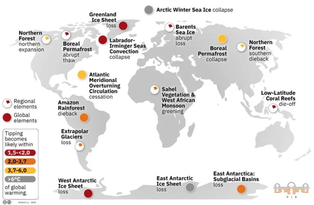
Why in news : Recently, a recent report released by the Potsdam Institute for Climate Impact Research (PIK), Germany highlighted an alarming trend regarding ocean acidification.
About :
What is ocean acidification ?
Ocean acidification occurs when oceans absorb approximately 25% of atmospheric CO2 produced by human activities such as the burning of fossil fuels, deforestation, and industrial processes. When CO2 dissolves in seawater, it reacts with water to form carbonic acid, which then dissociates into bicarbonate ions and hydrogen ions.Since the Industrial Revolution, the pH of the ocean's surface has decreased by approximately 0.1 units, from 8.2 to 8.1, representing a 30% increase in acidity.
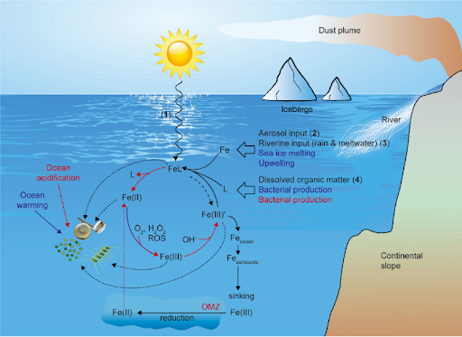
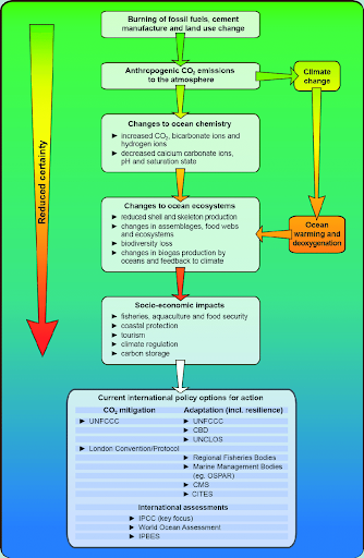
Causes of Ocean Acidification
- Anthropogenic CO2 Emissions : The rise in fossil fuel consumption, deforestation, and industrial processes have intensified since the industrial revolution. CO2 levels have increased from 280 ppm (pre-industrial levels) to over 420 ppm in 2024.
- Feedback Loops and Global Warming : As global temperatures rise, oceanic stratification (layering of water by temperature) increases, reducing the ocean's ability to absorb CO2, thus potentially exacerbating acidification. Warmer waters also reduce the solubility of gases like CO2.
- Natural Variability : While human activities are the primary contributors, natural events like volcanic eruptions and El Niño-Southern Oscillation (ENSO) can also influence short-term changes in ocean chemistry.
Impacts of Ocean Acidification
|
Impact on Coastal Communities |
Small island developing states (SIDS) and coastal nations are particularly vulnerable. Affects communities that depend on marine resources for their livelihoods, such as fishing and tourism. Eg. Coral Bleaching |
|
Economic Losses |
IPCC projects that global fisheries could suffer an annual loss of up to $100 billion by 2050 due to ocean acidification. |
|
Marine Biodiversity |
Studies on Pacific oysters and pteropods have shown shell dissolution in more acidic waters. |
|
Impact on Fisheries and Food Security |
The decline in the population of Alaskan king crabs is linked to ocean acidification, posing risks to the local fishing economy |
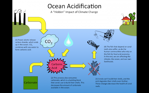
Impact of Ocean Acidification on Cloud Formation
- Most of the sulfur in the atmosphere comes from the ocean, primarily in the form of dimethylsulfide (DMS) produced by phytoplankton. Some of this DMS enters the atmosphere and forms sulfuric acid, which gathers into aerosols, tiny airborne particles.
- These aerosols help seed clouds that reflect sunlight, cooling the Earth. However, in acidified oceans, phytoplankton produce less DMS. This reduction in sulfur may lead to fewer clouds, contributing to higher global temperatures.
Ocean Acidification and Its Impact on Biogeochemical Cycles
The most direct link between ocean acidification and biogeochemical cycles is through the carbon cycle. Oceans act as a major carbon sink, absorbing about 25% of the CO2 emitted by human activities. This absorbed CO2 forms carbonic acid in seawater, which dissociates into bicarbonate and hydrogen ions, reducing the availability of carbonate ions essential for many marine organisms. This process not only impacts marine calcifying organisms (like corals and shellfish) but also alters the long-term storage of carbon in the ocean's biological carbon pump.
Ocean Acidification in Marine Heatwaves
Ocean acidification and warming oceans often occur in tandem, with acidified regions being more sensitive to marine heatwaves. Combined stresses also affect the resilience of marine ecosystems, leading to longer recovery times after extreme events.
Feedback Mechanisms
As Arctic ice melts, the surface area of the ocean exposed to atmospheric CO2 increases, accelerating acidification. The retreat of sea ice also affects albedo (reflectivity), leading to more heat absorption and further intensifying ocean acidification in these sensitive regions.
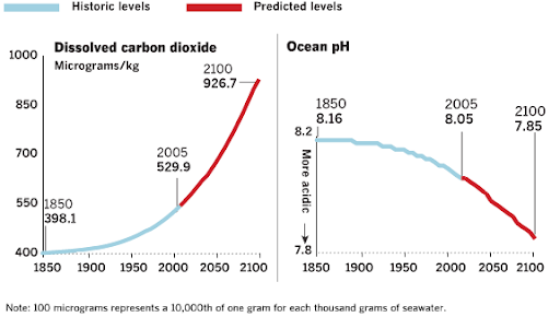
Initiatives to Curb Ocean Acidification
- Rio+20 Summit 2012 : Emphasized the importance of oceans in sustainable development and committed to protecting and restoring their health and resilience.
- UNESCO Intergovernmental Oceanographic Commission (IOC) : Oversees SDG 14 Target 3, aimed at minimizing and addressing ocean acidification. Helps nations coordinate resources to better understand and tackle this issue.
- International Ocean Carbon Coordination Project (IOCCP) : IOCCP works with other organizations to improve global monitoring of ocean acidification and its effects on ecosystems and climate.
- IAEA Ocean Acidification International Coordination Centre (OA-ICC), 2012 : Focuses on advancing science, capacity building, and communication to support informed decision-making on ocean acidification.
- Ocean Restoration Projects: The Blue Carbon Initiative focuses on conserving coastal ecosystems that sequester carbon, such as mangroves and salt marshes.
- National and Regional Initiatives : United States and New Zealand have implemented regional action plans focused on marine ecosystem resilience.
Source :
https://www.pik-potsdam.de/en/news/latest-news/latest-news
Where to use :
Paper 1 ( Geography Optional ) : Oceanography
Paper 1 ( General Studies ) : Environment conservation , Pollution & Degradation
PERMAFROST COLLAPSE
Why in news : Glaciologist S.N. Remya from Kerala, currently part of India’s Arctic Expedition at the Himadri research station in Norway, is studying permafrost collapse—a significant concern due to climate change.
About :
Permafrost is permanently frozen ground that remains at or below 0°C for at least two consecutive years. It is found in high-latitude regions like the Arctic, as well as in high-altitude mountain ranges like the Himalayas. It stores vast amounts of organic carbon, water, and ice, which are released when the permafrost thaws due to rising temperatures. The collapse of permafrost leads to terrain deformation, increased greenhouse gas emissions, and other ecological and geophysical changes
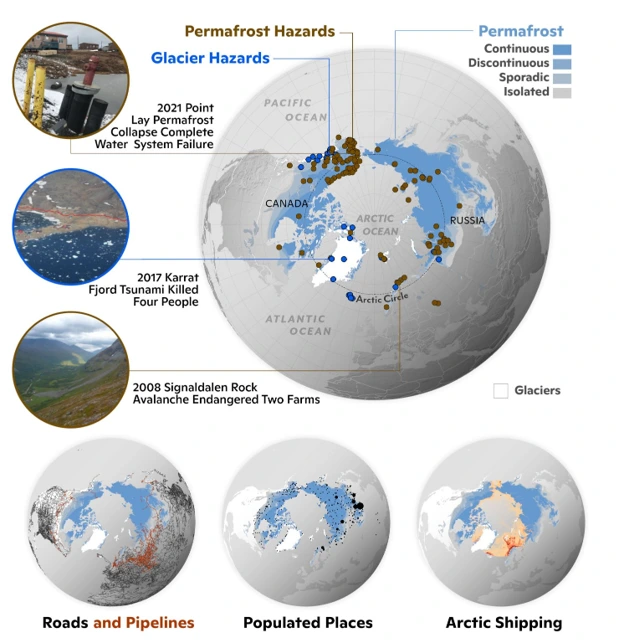
Mechanism of Permafrost Collapse
- Thawing Process: This process is most rapid in ice-rich permafrost, where the ground’s stability is compromised when the ice melts, leading to subsidence or "thermokarst" formations (irregular surfaces formed due to ice melting).
- Carbon Feedback Loop: Permafrost contains about 1,400 gigatons of carbon, twice as much as is currently present in the atmosphere. When it thaws, this carbon is released as methane and carbon dioxide, enhancing global warming further in a positive feedback loop.
Implications for Himalayas
- Glacial Lake Outburst Floods (GLOFs): The Tsho Rolpa glacial lake in Nepal is a high-risk GLOF site where the warming-induced collapse of permafrost could trigger catastrophic flooding. Satellite data indicate that 47 glacial lakes in the Himalayas are highly vulnerable to GLOFs due to potential permafrost collapse.
- Ecological and Habitat Destruction : The collapse of permafrost could change the hydrological balance in alpine meadows, impacting species like the snow leopard, Himalayan blue sheep, and high-altitude flora such as rhododendrons.
- Infrastructure Damage : Studies show that regions such as Lahaul-Spiti (Himachal Pradesh) and Leh-Ladakh have infrastructure built on permafrost zones.
- Instability and Landslides : A notable case is the Chamoli disaster in Uttarakhand in 2021, where experts suspect that melting permafrost and glacier destabilization contributed to the deadly landslide and floods that followed.
Mitigation and Adaptation Strategies for the Himalayas
- Enhanced Monitoring and Research: India’s Arctic and Himalayan research stations (like Himadri in Svalbard) are critical in gathering long-term data for both the Arctic and the Himalayas.
- Climate-Resilient Infrastructure: The development of elevated pipelines in Alaska’s Prudhoe Bay oil field to prevent subsidence due to permafrost collapse could offer lessons for building more resilient infrastructure in Ladakh and other high-altitude regions.
- Disaster Preparedness: The ICIMOD (International Centre for Integrated Mountain Development) has been conducting GLOF risk mapping in the Himalayas. Extending this to permafrost zones would allow for better disaster preparedness.
Source :
Where to use :
Paper I ( Geography Optional ) : Climatology
Paper II ( Geography Optional ) : Climate related and contemporary issues
GREENLAND LANDSLIDE
Why in news : Seismic stations across the world detected an unusual signal which persisted for 9 days.
About :
- Unlike typical earthquake tremors, this signal persisted for nine days and displayed characteristics unrelated to earthquakes, prompting a collaborative investigation by researchers from several countries.
- Scientists identified it as a "USO" — an unidentified seismic object. Ultimately, the origin of the signal was linked to a massive landslide in Greenland's remote Dickson Fjord.
- The landslide occurred when part of a mountainside collapsed, carrying a large section of glacial ice with it. The force of this collapse generated a towering 200-meter-high wave in the narrow Dickson Fjord. This wave became "trapped" in the fjord, oscillating back and forth and producing seismic signals that baffled scientists.
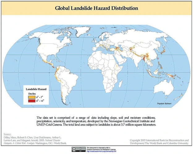
What caused it?
After investigation, researchers found that this unusual signal was caused by a massive landslide in Greenland.
- Landslide Event: A peak called Hvide Støvhorn collapsed, creating a massive avalanche of ice and rock, which then tumbled into the nearby Dickson Fjord.
A vast amount of rock and ice, equivalent to filling 10,000 Olympic-sized swimming pools, plunged into the fjord, triggering a mega-tsunami with a wave reaching 200 meters in height.The landslide also initiated a seiche, a back-and-forth wave within the fjord, which lasted for nine days. The immense power of the landslide was driven by glacier thinning, a consequence of global warming. - Tsunami Generation: The force of the falling ice and rock displaced a massive volume of water in the fjord, creating a mega-tsunami—a giant wave about 200 meters high, nearly three times the height of the Srirangam Temple.
- Seismic Waves: As the landslide unfolded and the mega-tsunami formed, seismic waves were generated, traveling across the globe like a ringing bell. These waves were detected by seismic stations worldwide.The seismic waves generated by the landslide were different from typical earthquake signals. They displayed a single frequency, similar to the sound of a violin string being plucked, rather than the complex patterns typical of earthquake tremors.
These waves propagated globally, resonating for days as the impact of the landslide rang out like a gong, causing the Earth to vibrate.
The Seiche Effect
Within the fjord, the waves reflected off the steep cliffs, producing a phenomenon known as a seiche. This occurs when water oscillates back and forth, creating recurring waves. These waves continued to reverberate within the fjord for over nine days, corresponding to the prolonged seismic signal that was recorded.
Geographical Importance: The Dickson Fjord is a distinct geographical feature—deep and U-shaped—causing the waves to behave in this unusual manner. Moreover, the warming climate is leading to glacial melt in the region, increasing the likelihood of such landslides occurring more frequently.
Source :
https://www.thehindu.com/sci-tech/science/massive-greenland-landslide-sent-seismic-waves-around-earth-for-9-days/article68673331.ece
Where to use :
Paper II ( Geography Optional ) : Landslides
Paper III ( General Studies ) : Disaster Management
Greenhushing
Greenhushing : Greenhushing occurs when firms under report or strategically withhold information about their environmental goals and achievements. Greenhushing firms don’t advertise their green credentials or deliberately remain silent about their future commitments to environmental sustainability.
Oxygen Bird Park
Oxygen Bird Park : The Oxygen Bird Park is a sanctuary that offers a natural habitat for a variety of bird species, with a focus on conservation and eco-tourism. These parks are typically designed to support biodiversity, providing a green lung or "oxygen hub" for urban areas, hence the name. It symbolizes green spaces that enhance both air quality and biodiversity in densely populated areas.
Kumki
Kumki : Kumki is a term used in India for trained captive Asian elephants used in operations to trap wild elephants, sometimes to rescue or to provide medical treatment to an injured or trapped wild elephant. Kumkis are used for capturing, calming and herding wild elephants or to lead wild elephants away in conflict situations..
Magnetic storms
Magnetic storms : Magnetic storms, also known as geomagnetic storms, are disturbances in the Earth's magnetosphere caused by the interaction of the Earth's magnetic field with charged particles emitted from the Sun, typically during solar wind events such as solar flares or coronal mass ejections (CMEs).
Evershed effect
Evershed effect : The Evershed effect, named after the British astronomer John Evershed, is the radial flow of gas across the photospheric surface of the penumbra of sunspots from the inner border with the umbra towards the outer edge. The speed varies from around 1 km/s at the border between the umbra and the penumbra to a maximum of around double this in the middle of the penumbra and falls off to zero at the outer edge of the penumbra.
WAYANAD LANDSLIDES IN KERALA
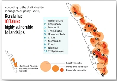
The region predominantly has laterite soil, which is highly prone to erosion. The steep and undulating terrain of Wayanad makes it naturally susceptible to landslides. Wayanad receives intense and prolonged monsoon rains that cause water infiltration, leading to soil saturation and increased pore water pressure, which destabilizes slopes. Large-scale deforestation for agriculture and settlement reduces the binding capacity of the soil and its ability to absorb water, exacerbating the risk of landslides. According to the landslide atlas in 2023, 10 out of the 30 most landslide-prone districts in India were located in Kerala, with Wayanad ranked 13th. Of the 3,782 landslides between 2015 and 2022, 2,239 (nearly 59.2%) were reported from Kerala. In 2022, the Ministry of Earth Sciences informed that Kerala witnessed the highest number of major landslides in the country over the past seven years.
Source :
https://www.thehindu.com/news/national/kerala/wayanad-landslide-how-two-villages-vanished-overnight/article68506601.ece
Where to Use :
Paper I ( Geography Optional ) : Applied Geomorphology
Paper II ( Geography optional ) : Physical setting and Landslides
Paper III ( General Studies ) : Disasters
Places in News - 10 October 2024
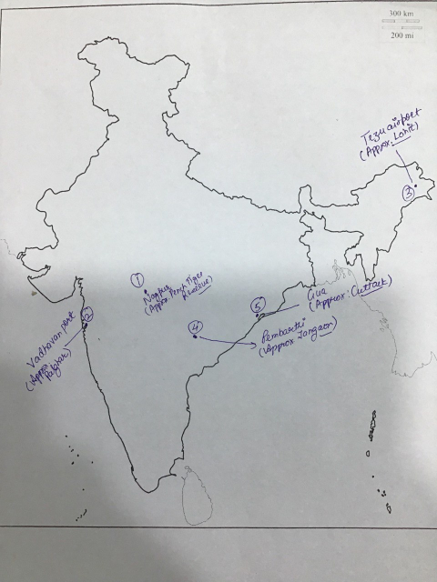
1. Nagpur
Why in news: Recently, the Ministry of Road Transport & Highways inaugurated Oxygen Bird Park (Amrit Mahotsav Park) in Nagpur, Maharashtra.
- Nagpur is the third-largest city of the Indian state of Maharashtra after Mumbai and Pune.
- It is called the heart of India because of its central geographical location.
- It is the largest and most populated city in central India. Also known as the "Orange City", Nagpur is the 13th largest city in India by population.
- Approx : Pench Tiger Reserve.
2. Vadhavan
Why in news : India has ambitious plans for mega ports across the country, including the recently approved Rs 76,220 crore port at Vadhavan in Maharashtra.
- It is an approved greenfield deep-sea port in Vadhavan, Palghar District, Maharashtra.
- The port will be developed as an all-weather deep draft major port, which will include the development of core infrastructure, terminals, and other commercial infrastructure in public-private partnership (PPP) mode.
- The port will be constructed through a Special Purpose Vehicle (SPV)
- Approx: Palghar
3. Tezu airport
Why in news : Union Minister Jyotiraditya Scindia inaugurates New Terminal Building at Tezu Airport in Arunachal Pradesh.
- It is a domestic airport serving the city of Tezu and adjoining Lohit district of Arunachal Pradesh, India.
- It is India's easternmost airport, operated by the Airports Authority of India (AAI).
- It was one of five airports that were shortlisted in 2015 for the implementation of AAI's "no-frills model", which will provide only essential services needed to operationalise the airport
- Approx : Lohit
4. Pembarthi
Why in news : Pembarthi adjudged best tourism village in Telangana.
- Pembarthy is a village in Jangaon district, Telangana, India
- It is famous for its metal handicrafts and brass works.
- Pembarthi has implemented a ban on single-use plastic to protect the environment, species, and water resources.
- Approx : Jangaon
5. Gua
Why in news: Chief Minister paid tribute to the martyrs of the Gua firing incident.
- Gua is a census town in Keonjhar district in the Indian state of Orissa.
- It is a mining village situated in the Chotanagpur Plateau. The mines are operated by the Steel Authority of India Limited
- The source of water at Gua is the South Karo River.
- Gua, a beautiful place amidst Saranda Forest is well connected by rail and road to major township
- Approx : Cuttack
Fortnightly KOSMOS MCQs Practice - 10th October 2024
Q1. Consider the following statements related to Tea Production in India,
- India holds the position of being the world's top tea producer.
- A significant portion of India's tea exports consists of black tea.
- Assam, West Bengal, Tamil Nadu, and Kerala contribute the largest share of India's overall tea output.
How many of the above statements is/are correct?
- Only one
- Only two
- All three
- None
Q2. With reference to Green Climate Fund (GCF), consider the following statements:
- It is the first climate finance fund created independently of the United Nations Framework Convention on Climate Change (UNFCCC).
- Founded in 2010, it is headquartered in the Republic of Korea.
- The fund provides support for projects, programs, and policies in developing countries, focusing on key priority areas through specialized thematic funding channels.
How many of the statements given above is/are correct?
- Only one
- Only two
- All three
- None
Q3. Consider the following features:
- In Manipur, they are referred to as Kahuaipuina.
- These birds migrate from northern China, eastern Mongolia, and far eastern Russia to South Africa.
- Their diet mainly consists of insects.
Which of the following species is being described above?
- Siberian Crane
- Amur Falcon
- Black Kite
- Asian Paradise Flycatche
Q4. Consider the following statements , regarding the International Big Cat Alliance (IBCA) :
- This is a coalition of 96 countries, both big cat range and non-range nations, focused on conserving 7 species of big cats and their habitats.
- It was officially introduced in April 2023, commemorating the 50th anniversary of Project Tiger.
Which of the statements given above is/are correct?
- Only 1
- Only 2
- Both 1 and 2
- Neither 1 nor 2
Q5. Consider the following statements:
- Algae are basic, autotrophic organisms that thrive in aquatic habitats.
- Fungi are multicellular organisms with cell walls made of cellulose.
Which of the statements given above is/are correct?
- 1 Only
- 2 Only
- Both 1 and 2
- Neither 1 nor 2
Q6. Consider the following statements regarding earthquakes:
- The location where energy is released during an earthquake is known as the epicenter.
- P-waves, similar to sound waves, can move through gases, liquids, and solids.
- The Richter scale gauges intensity, indicating the amount of energy released in earthquakes.
Which of the statements given above is/are correct?
- 1 and 2 only
- 2 only
- 1 and 3 only
- 1, 2, and 3
Q7. Consider the following statements regarding Ocean Acidification.
- Ocean acidification is decreasing the ocean's ability to absorb human-caused CO2.
- Ocean acidification negatively impacts marine life by eroding their shells and skeletons.
- It is happening more rapidly in the Arctic compared to the global oceans.
How many of the statements given above is/are correct?
- Only One
- Only Two
- All Three
- None
Q8. Consider the following statements:
- The Sun's corona is the outermost part of the Sun's atmosphere.
- The Solar cycle refers to the cycle of change in the Sun’s magnetic field.
- Auroras are caused by the change in the sunspots on the sun's surface.
Which of the statements given above is/are correct?
- 1 and 2 only
- 2 only
- 1 and 3 only
- 1, 2, and 3
Q9. Consider the following statements about Kumki Elephants:
- These are trained, captive Asian elephants.
- They are capable of capturing, rescuing, treating injured wild elephants, and moving them away from human habitats.
- Tamil Nadu recently transferred 62 kumki elephants to other states.
Which of the statements given above is/are correct?
- 1 and 2 only
- 2 and 3 only
- 1 and 3 only
- 1, 2, and 3
Q10. Consider the following statements about "Oxygen Bird Park" :
- It is an environmental initiative launched by the Ministry of Environment, Forest, and Climate Change.
- The park is created to replicate natural habitats and protect both local and migratory bird species.
- Its goal is to conserve rare and endangered tree species indigenous to Central India, such as the Indian Bael and Yellow Flame of the Forest.
Which of the statements given above is/are correct?
- 1 and 2 only
- 2 and 3 only
- 1 and 3 only
- 1, 2, and 3
Share the article
Edukemy’s Current Affairs Quiz is published with multiple choice questions for UPSC exams
MCQ
Get Latest Updates on Offers, Event dates, and free Mentorship sessions.

Get in touch with our Expert Academic Counsellors 👋
FAQs
Geography Current Affairs focuses on the contemporary issues, events, and developments in the field of geography. It covers recent geographical phenomena, environmental changes, geopolitical shifts, and related news. This differs from regular geography studies which may focus more on foundational concepts, historical contexts, and theoretical frameworks.
Updates are provided regularly to ensure that subscribers stay informed about the latest developments in geography. Typically, updates are provided on a fortnightly basis, depending on the frequency of significant events and changes in the field.
Absolutely. Geography Current Affairs serves as a valuable resource not only for Geography optional but also for GS papers, especially GS Paper 1 (covering Indian Heritage and Culture, History, and Geography of the World and Society) and GS Paper 3 (covering Technology, Economic Development, Biodiversity, Environment, Security, and Disaster Management). It aids in building a holistic understanding of various topics and strengthens answer-writing skills by incorporating contemporary examples and perspectives.
Geography Current Affairs holds immense importance for UPSC preparation, particularly for aspirants opting for Geography optional. It helps candidates stay updated with the latest developments, geographical phenomena, environmental issues, and geopolitical shifts worldwide, aligning them with the dynamic nature of the subject as tested in the UPSC examinations.


