
18 Sep
Rising Heat-Waves in wake of Climate Change - Need for Sustainable Development
Rising Heat-Waves in wake of Climate Change - Need for Sustainable Development
- In news: The U.N.'s Intergovernmental Panel on Climate Change latest report found that severe heat waves that previously occurred once every 50 years are now likely to happen once per decade.
- Background:
- Heatwave is/are period of prolonged abnormally high surface temperatures. The WMO defines it as five or more consecutive days during which the daily maximum temperature surpasses the average maximum temperature by 5 °C (9 °F) or more.
- Some countries have adopted their own standards. For example, the IMD requires that temperatures increase 5–6 °C (9–10.8 °F) or more above the normal temperature, whereas the U.S. National Weather Service defines a heat wave as a spell of “abnormally and uncomfortably hot and unusually humid weather” spanning two days or more.
- Globally, the increasing frequency and intensity of heat waves observed since the 1950s has been associated with climate change. Such weather phenomena may be characterized by low humidity, which may exacerbate drought, or high humidity, which may exacerbate the health effects of heat-related stress, which include heat exhaustion, dehydration, and heatstroke.
- Heat waves may span several days to several weeks and are significant causes of weather -related mortality, affecting developed and developing countries alike. Therefore in wake of rising temperature due to climate change, sustainable development is universal call to maintain a balance between economic advancementwhile protecting the environment in order to meet the needs of the present as well the future generations.
- Rising heatwaves- due to climate change:

- The significant increase in heat extremes we have witnessed associated with shift in the global average temperature in consistent with climate change.
- Climate change caused by greenhouse gases from burning fossil fuels is poised to make heat waves longer, more intense, and more frequent. The burning of fossil fuels adds greenhouse gases to the atmosphere, which traps more heat energy and pushes up average temperatures — which, in turn, also pushes up extreme temperatures which is unevenly distributed.
- As climate change intensifies, disruptions to traditional global atmospheric circulation systems, such as the jet stream in the northern hemisphere, are expected across the planet, leading to more frequent and intense extreme climate events like heat waves
- The effects of warming can vary by latitude, too. Polar region are warming up to three times as fast as the planetary average, fueling heat waves in the Arctic. In fact, cooler parts of the planet are heating up faster than places closer to the equator.
- Similarly, significant increases in marine heatwave (MHW) intensity and count of annual MHW days are projected to accelerate, with many parts of the ocean reaching a near-permanent MHW state by the late 21st century. The Intergovernmental Panel on Climate Change (IPCC) report projects that the global ocean will continue to warm well and warming in the upper ocean is projected to be between 0.6°C and 2°C. We can therefore expect a future continuation, and possibly acceleration, of the historic warming-driven changes in marine heatwaves.
- Since heat waves are projected to rise in wake of climate change impacts they can have drastic impacts on development:

- Cities are more vulnerable to heat waves than rural areas :
- As average global temperatures rise, so too does the probability of more extreme hot temperature anomalies, resulting in earlier, longer and more frequent heatwaves.
- Heatwaves now pose a recurring challenge on all inhabited continents and generate an increasing range of threats to human lives and well-being, particularly in cities where built environments magnify heat exposure.
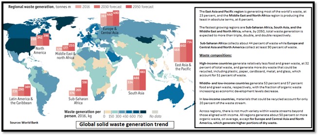
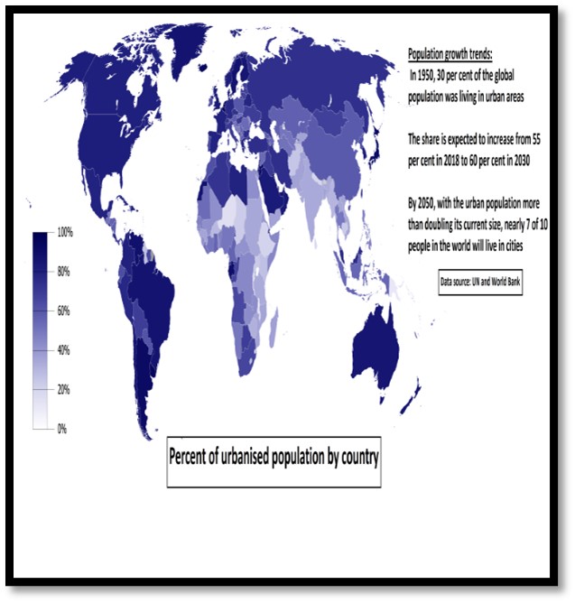
- This matters because close to 70% of the world’s population is expected to live in cities by 2050 and will be exposed to extreme heat.
- Urban regions experience hotter conditions compared to their natural surroundings, due to a number of factors that modulate urban climate and form ‘Urban Heat Islands’ (UHIs).
- The main contributing factors are changes in the surface energy budget due to increased heat storage capacity of artificial surfaces like paved and concrete surfaces, reduction of evaporative cooling, and difference in convective and advective flows and increased anthropogenic heat release in urban areas.
- Urban areas lack vegetation that create shade and cool the air through evapotranspiration.
- Urban challenges like sprawling, congestion, traffic and vehicular emission pollution traps additional heat from the atmosphere in urban areas.
- At the same time, global warming forcing has resulted in more frequent, severe and longer lasting excessive heat events (heat waves) worldwide and there is strong evidence that the frequency and severity of such extreme events will increase further in the near future.
Case study: Verkhoyansk, a town in Siberia- exceptional temperature rise due to anthropogenic climate change.
Verkhoyansk has recorded the highest temperature in the Arctic circle in the last 140 years at 38 degree celsius. This is around 18°C higher than the normal temperature for this time of the year for the place. With global warming, temperatures are getting warmer, and therefore, the probability of heat waves and prolonged warm periods are strongly increasing. This new record has an imprint of global warming and the impact of such warming causing wide-scale impacts including wildfires, loss of permafrost, and an invasion of pests.

- Strategies for sustainable development:
- The most effective way to avoid the negative impacts of heatwaves is to mitigate climate change by reducing greenhouse gas emissions (GHG) and minimize the rise in global mean temperatures. For example: shifts towards cleaner energies like solar energy, wind energy etc will not only reduce GHG emissions, but will also reduce localized air pollution and heat island effects within cities.
- Decongesting and depolluting urban areas by developing satellite towns, counter magnet cities and linking them with central business district through smart mobility systems like Bus Rapid Transit (BRT) system etc.
- Plan to cool our cities: To reduce heatwaves, need to modify our urban planning standards and building bylaws to enhance green areas and water bodies and promote cool roofs and green buildings, among other things.
- Improved urban design and sustainable planning that increases the amount of and access to green space and other cool environments (pools, air-conditioned spaces) and encourages white roofs, will play an important role in avoiding heat-related illness, in reducing surface temperatures, and in providing a wealth of other nature-related benefits.
- Need to Build Resilience: A set of strategies to build resilience to extreme heat, “Resilience Strategies for Extreme Heat.” Some strategies include:
- Creating heat preparedness plans, identifying vulnerable populations, and opening cooling centers during extreme heat.
- Installing cool and green roofs and cool pavement to reduce the urban heat island effect.
- Planting trees to provide shade and evapo-transpiration cools the air around trees.
- Pursuing energy efficiency to reduce demand on the electricity grid, especially during heat waves.
Case study: France has developed national action plans to tackle the problem of heat waves.
Components of the plan includes:
-
- Preventive measures to raise awareness and tackle the health consequences of heatwaves.
- The National Public Health Agency of France informs people about the vigilance and action plan and it provides all the information material such to regional health services, local administration and the associative network.
- Media are effectively used to disseminate information on a regular basis during the emergency phase — when heatwaves are declared.
- Heatwave warning levels and the vigilance required are assigned colours — Yellow (level 2), Orange (level 3) and Red (level 4).
- It is updated every year and has helped the country to reduce mortality and health consequences associated with heatwaves.

- Need for mitigating heatwaves effect: To achieve Sustainable Development Goals (SDG)
Mitigation of heatwaves can contribute to the achievement of the SDGs and is directly linked to all 17 SDGs.
For example:
-
- No poverty (SDG 1): Increased extreme heat without cooling provisions is linked to lower productivity from land and income, exacerbating poverty especially in developing countries. Reduced cooling from decreased urban green spaces is also linked to increased income poverty.
- Quality education (SDG 4): Performance of pupils in schools reduces considerably where hot weather cannot be offset by the availability of cooling.
- Gender equality (SDG 5): Household food-related activities are often women’s responsibilities, and the opportunities from cooling and refrigeration enable women to undertake small businesses and reduce time spent on daily food provision.
- Way forward:
- Implementing the New Urban Agenda: The New Urban Agenda works as an accelerator of the Sustainable Development Goals (SDGs), particularly SDG 11– Make cities and human settlements inclusive, safe, resilient and sustainable.
- Circular strategies could also help cut global emissions and achieve climate goals :
- Build multi-occupancy dwellings to reduce overall floor space and optimize resource efficiency.
- Reduce travel through a range of work solutions and interventions, including shared and virtual offices, telecommuting and working from home.
- Encourage shared travel interventions like car clubs, car pools, ride-sharing, public transport and park-and-ride.
Where it can be used
Paper1: (Climate change, Sea level changes, Problems of urbanization, Sustainable development)
Paper2: (Problems of Urbanization, Sustainable development) and GS 3 (Environmental degradation)
Links:
- Climate change impact on agriculture leads to 1.5 per cent loss in India’s GDP
- Climate Change and its Impact on Agricultural Productivity in India
- Climate Change and Indian Agriculture
- Climate change affects major crops in India: Study
- Extreme climate change to hit agri production in state by 2033: Study
Coral Reefs: An ecosystem under threat
Why in news: According to IPCCC AR6, we might lose all the coral reefs in the worldby the end of the century unless there are drastic reductions in the Green House Gas emissions.
Introduction:Coral reefs are incredibly important and sustain a wide variety of marine life. They also protect coastlines from erosions from waves and storms, sink carbon and nitrogen and help recycle nutrients. Their loss would have devastating consequences not only for marine life, but also for over a billion people globally who benefit directly or indirectly from them for food and nourishment.
Threats to Coral Reef ecosystem:

Global Threats:Climate change has been the main factor which has affected the health of Coral Ecosystems worldwide.
- Ocean Warming:The Ocean absorbs most of the excess heat from greenhouse gas emissions, leading to rising ocean temperatures, which cause coral bleaching and the loss of breeding grounds for marine fishes and mammals. Sea level rise, increased frequency and intensity of tropical storms, and altered ocean circulation patterns, can also affect coral reefs and lead to coral bleaching.

- Ocean Acidification:The Ocean absorbs about 30 percent of the CO2that is released in the atmosphere. Absorbed CO2increases the concentration of hydrogen ions and decreased carbonate ions.It results in difficulty in building and maintaining shells and other calcium carbonate structures for calcifying organisms such as oysters, clams, shallow water corals, deep sea corals, and calcareous plankton etc. resulting in weak reef formation.
- Over Fishing:

- Pollution:Pollution can impede coral growth and reproduction, disrupt overall ecological function, and cause disease and mortality in sensitivespecies.
Local Threats:Ascoral reefs occur in shallow water near shore,they are particularly vulnerable to the direct and indirect impacts of human activities such as:
- Coastal Harvesting: for the aquarium trade, jewellery, and curios.
- Unsustainable Coastal Development: Coastal development such as land filling, dredging, coral and sand mining for construction or indirect, such as increased runoff of sediment and pollutants.
- Invasive Species: The alien species introduced due to human activities compete with the existing organisms for resources resulting in alteration of ecosystem dynamics, biodiversity loss and reduction of the resilience of ecosystems.
- Crown of thorns starfish: This nocturnal starfish feeds on corals. A 2012 study by the Australian Institute of Marine Science revealed that crown-of-thorns starfish and tropical cyclones were the two leading causes of coral cover loss on the Great Barrier Reef over the previous 27 years.


Way Forward: In the latest IPCC report by UNFCCC it has been pointed that ‘Human influence has warmed the climate at a rate that is unprecedented in at least the last 2000 years.” We must act with evidence-based urgency, ambition and innovation to change the trajectory for the coral reef ecosystem, which is the canary in the coalmine for climate’s impact on oceans.
Where it can be used?
This can be used in topics related to Paper 1(Coral reefs, Coral bleaching, Climate change), Paper 2(Sustainable development) and GS 3 (Environmental Pollution and Degradation).
Sources:
- Marine pollution, coastal development: Coral reefs need to be saved (downtoearth.org.in)
- Threats to Coral Reefs | Coral Reef Alliance
- Threats to the Reef - Great Barrier Reef Foundation - Great Barrier Reef Foundation
- What You Can Do to Help Protect Coral Reefs | US EPA
Picture Source:
NMEO-OP: Addressing the challenges of Oil Palm cultivation in India
Why in news: Recently, cabinet approved National Mission on Edible Oils- Oil Pam (NMEO-OP), with special focus on North East region and the Andaman & Nicobar Islands.
Potential for oil palm cultivation in India:

Several challenges faced by the oil palm cultivation in India:
- Stagnant production: 98% our oil palm needs are met by imports asdomestic production is not sufficient to meet the demand.
- Long gestation period: Oil palm trees start producing Fresh Fruit Bunches (FFBs, from which palm oil is extracted) about 4 years after their planting. This restricts income flow to farmers for at least 4-5 years.
- Price volatility: Currently the prices of FFBs are linked to international Crude Palm Oil prices which are subjected to severe volatility thus making it less remunerative for oil palm farmers.
- Erratic monsoon: With increasing climate change, alteration in the monsoon patterns is leading to shortage of water in the oil palm areas, which in turn hampering the oil palm production.
- Inadequate resources such as shortage of planting material, lack of investment and proper market facilities.
- Competition from other economically viable crops sugarcane, banana, coconut etc. making the oil palm cultivation less remunerative for the farmers.
How NMEO-OP is going to address the challenges of oil palm cultivation in India?
- Price assurance through Viability Price: For the first time, Government of India will give a price assurance to the oil farmers for FFBs. This will be known as Viability Price. This will protect farmers from the volatility of international crude palm oil prices and inculcate confidence on the farmers to go for increased oil palm cultivation.
- Financial assistance to seed gardens: To address the issue of shortage of planting material in the country, seed gardens will be provided assistance up to Rs. 80 lakh for 15 ha in rest of India & Rs. 100 Lakh for 15 ha in North East and Andaman regions.
- Special provisions for North East and Andaman Regions: To increase the area under oil palm cultivation, further assistance will be provided for the North East & Andaman regions in which special provisions is being made for half-moon terrace cultivation, bio fencing and land clearance along with integrated farming which is in line with Bringing Green Revolution to Eastern India (BGREI).
- Self-sufficiency: Above decisions would benefit farmers and make it viable for the industry to continue contributing towards making the country self-sufficient in edible oil requirements by increasing the area under oil palm cultivation from about 3.7 lakh ha in 2019-20 to 10 lakh ha by 2025-26 and to realize the goal of AtmaNirbhar Bharat.

Concerns that still remain with the NMEO-OP:
- Environmental concerns: It will lead to massive reduction of forest cover and fresh water pollution (as a palm oil mill generates 2.5 metric tons of effluent for every metric ton of palm oil it produces) in biodiverse and ecologically sensitive zones of North-East and Andaman regions.

- Social concerns: Cutting down forests for oil palm cultivations in the North East and Andaman regions will lead to conflict between government policies and customary land rights which are major livelihood sources for forest dependent communities & also indigenous communities depend on forests for MFP.
Way forward:
- Use of Agro Climatic Regionalization and Agro Ecological Regionalization for sustainable oil palm cultivation.
- Agricultural diversification for supporting the farmers in the period between planting of seeds and production of FFBs.
- Indian Palm Oil Sustainability framework (IPOS) for promoting sustainable palm oil production and trade.
- Converting fallow land for Oil Palmcultivation especially in the dry areas like Bundelkhand and interior parts of peninsular plateau.
- Sustainable Palm Oil Coalition for India (India-SPOC) was launched in 2018, as a collaborative effort between Centre for Responsible Business (CRB), World Wide Fund for Nature (WWF) – India, Roundtable on Sustainable Palm Oil (RSPO) and Rainforest Alliance (RA).
Where it can be used:
Paper 1 (Environmental Degradation, Sustainable development), Paper 2 (Agro-based industries, Dry land farming, Rural area development, Sustainable development),
Sources:
Bioswales
About:
- They are landscape features that collect polluted stormwater runoff, soak it into the ground, and filter out pollution.
- They are designed to capture runoff coming from larger areas of impervious surfaces like streets and parking lots.
- They are used extensively in the USA and Germany, also implemented in China, the Netherlands, Japan, South Korea, Japan,


Benefits:
- Help protect streams and lakes from pollution by reducing stormwater runoff
- Reduce the risk of flooding and drainage problems
- Provide habitat for pollinators and birds
- Improve air quality
Bioswales are the most effective type of green infrastructure facility in slowing runoff velocity and cleansing water while recharging the underlying groundwater table.
Atmospheric blocking
Atmospheric blocking refers to stationary, long-lasting blocked weather patterns that are often defined by a persistent high pressure system in combination with one or two low pressure systems.
Impacts of Atmospheric blocking -
- It leads to a stagnation of weather patterns.
- In the case of blocking, the same pattern repeats for several days to even weeks. This can lead to flooding, drought, above normal temperatures, below normal temperatures and other weather extremes.
- Atmospheric blocking is best seen on upper air analysis and forecast charts. Blocking over large regions is most common with high-pressure since high pressure covers a large spatial area and tends to move slower than low pressure. In some instances, low pressure can also cause an atmospheric block.
The five common types of blocks are the Omega block (shown in figure 1), the Rex block, the Ring of Fire, Split flow and the Cut-off low.

Case study
The Pantanal, the world’s largest tropical wetland, located in south-central Brazil, has been affected by the worst drought in the past 50 years depicted in figure 2. The drought was caused because of ‘atmospheric blocking’. Usually, rain in the Pantanal is caused by warm humid air travelling over the North Atlantic Ocean and the Amazon rainforest meeting cold air blowing from the South Atlantic. In 2019-2020, however, a high pressure bubble prevented the two from meeting and caused a drought.

Figure 2: Pantanal crisis due to Atmospheric blocking
Pilibhit Tiger Reserve
|
Pilibhit Tiger Reserve
|
|
Bageshwar
|
|
Thamirabarani River
|
|
Pakke Tiger Reserve
|
|
Kumutiya River
|
|
Angul
|

Biochore
A biochore is a biogeographical unit and is subdivision of the biosphere consisting of biotopes that resemble one another and thus are colonized by similar biota. These are determined by the degree to which moisture is available to plants in a scale ranging from abundant (forest biome) to almost none (desert biome). Also, within each biome, conditions of temperature are vastly different from low to high latitudes and from low to high altitudes.
The biochore classification system follows the works of Pierre Dansereau and is based on principles developed by Schimper and Rubel.


City Development: Bucaramanga
Several challenges faced by Bucaramanga:
- It’s a city nestled in Columbia’srugged Eastern Cordillera, landlocked and without any railroad links.
- Erosion of its traditional economic structures because of changing circumstances (E.g. Impact of globalization on trade & commerce)
- Economic and demographicdisruption brought about by natural and manmade disasters (E.g. Columbia experienced one of the longest armed conflict in the modern times).
Despite all the challenges, Bucaramanga is one of the best performing economies of Latin America. It has one of the highest GDP per capita and lowest unemployment rate in Columbia.
What contributed to the development of Bucaramanga?
- Mixed public – private model: Local government and private sector share responsibilities for carrying out economic development functions of the city. E.g. PPPs for affordable housing and developing BRT system in Bucaramanga.
- Having dedicated entities or government departments responsible for regional development (E.g. Regional Competitive Commission of Bucaramanga).
- Using established economic development best practices and benchmarking tools (E.g. Bucaramanga used Michael Porter’s Cluster theory as a guide to develop a planning strategy for the city which involves dividing the city into several clusters based on geographical and economic advantages).
- Establishing long term, measurable goals: In Bucaramanga, the RCC set a goal to double the city’s per capita GDP in 10 years.
- Showed willingness to let go of local industries that may no longer be globally competitive (foot wear & apparel in Bucaramanga).
- Designing and funding customized worker training programs in response to industry needs.
- Fostering industry-academia partnershipsfor skill development, to address the need of firms and to boost employment rates within the city.

Many of the above practices can be replicated for the development of Indian cities.
Where it can be used?
This case study can be used in topics of Paper 1 (Economic development, development of cities), Paper2 (Urban area development, Regional Planning) and GS1 (Urbanization, Developmental issues).
Places in news - Pilibhit Tiger Reserve
|
Pilibhit Tiger Reserve
|
|
Bageshwar
|
|
Thamirabarani River
|
|
Pakke Tiger Reserve
|
|
Kumutiya River
|
|
Angul
|

Share the article
Get Latest Updates on Offers, Event dates, and free Mentorship sessions.

Get in touch with our Expert Academic Counsellors 👋
FAQs
Geography Current Affairs focuses on the contemporary issues, events, and developments in the field of geography. It covers recent geographical phenomena, environmental changes, geopolitical shifts, and related news. This differs from regular geography studies which may focus more on foundational concepts, historical contexts, and theoretical frameworks.
Updates are provided regularly to ensure that subscribers stay informed about the latest developments in geography. Typically, updates are provided on a fortnightly basis, depending on the frequency of significant events and changes in the field.
Absolutely. Geography Current Affairs serves as a valuable resource not only for Geography optional but also for GS papers, especially GS Paper 1 (covering Indian Heritage and Culture, History, and Geography of the World and Society) and GS Paper 3 (covering Technology, Economic Development, Biodiversity, Environment, Security, and Disaster Management). It aids in building a holistic understanding of various topics and strengthens answer-writing skills by incorporating contemporary examples and perspectives.
Geography Current Affairs holds immense importance for UPSC preparation, particularly for aspirants opting for Geography optional. It helps candidates stay updated with the latest developments, geographical phenomena, environmental issues, and geopolitical shifts worldwide, aligning them with the dynamic nature of the subject as tested in the UPSC examinations.