24 Apr to 10 May, 2024
REGENERATIVE BLUE ECONOMY
Why in news : The International Union for Conservation of Nature (IUCN) has released a report outlining a roadmap for a Regenerative Blue Economy (RBE).
About :
What is the Regenerative Blue economy ?
-
A regenerative Blue Economy is an economic model that combines rigorous and effective regeneration and protection of the Ocean and marine and coastal ecosystems with sustainable, low, or no carbon economic activities, and fair prosperity for people and the planet, now and in the future
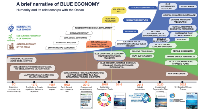
Significance of Regenerative Blue Economy for Global Sustainability
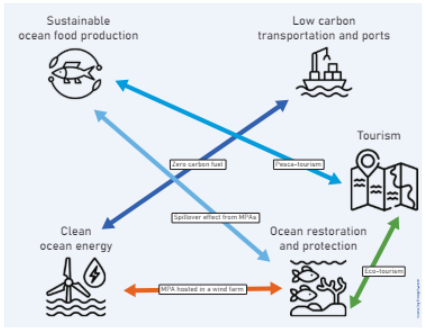
- Birodiversity Conservation: Initiatives like marine protected areas (MPAs) not only safeguard habitats and species but also ensure the longevity of fisheries. Eg. Great Barrier Reef Marine Park suppots tourism and fisheries.
- Climate Change Mitigation: Mangrove restoration and seaweed farming not only protect shorelines and improve water quality but also capture significant amounts of carbon dioxide. Eg. Projects like the Thor Heyerdahl Climate Park in Myanmar utilize mangrove reforestation to enhance carbon sinks, contributing to climate change mitigation.
- Economic Diversification and Resilience: A regenerative blue economy promotes economic diversification by developing sustainable marine-based industries, such as renewable energy (wind, tidal), sustainable aquaculture, and ecotourism. Eg. Development of offshore wind farms in countries like Denmark has created jobs while reducing reliance on fossil fuels.
- Deep Sea Minerals : Deep sea minerals, like manganese nodules and cobalt crusts, are vital for the Blue Economy. Eg. Papua New Guinea has explored deep sea mining in the Bismarck Sea, targeting mineral-rich hydrothermal vents to potentially enhance its Blue Economy
- Pollution Reduction: Initiatives like the International Coastal Cleanup campaign mobilize global communities to tackle marine debris, thereby protecting marine life and enhancing the sustainability of ocean resources.
- Sustainable Livelihoods: In the Philippines, community-based projects that incorporate sustainable harvests of fish and other marine life have proven successful in both conserving biodiversity and enhancing local economies.
The Pillars of the Regenerative Blue Economy
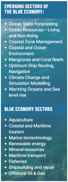
- Sustainable Marine Resource Utilization: Exploiting ocean resources (like fish and minerals) sustainably to ensure they remain available for future generations.
- Marine Energy: Harnessing renewable energy from ocean sources such as tidal, wave, and wind power.
- Aquaculture: Cultivating marine and freshwater biomass (like fish and algae) in a responsible manner to support food security and economic growth.
- Maritime Transport and Logistics: Optimizing shipping routes and operations to reduce environmental impact and enhance efficiency.
- Coastal Tourism: Developing eco-friendly coastal and maritime tourism that supports local economies without damaging ecosystems.
- Waste Management: Implementing measures to reduce marine pollution by improving waste disposal and recycling processes in coastal and oceanic zones.
- Ocean Governance: Establishing effective legal and policy frameworks to manage ocean resources and space equitably and sustainably.
Challenges and Limitations
- Economic and Infrastructure Limitations: Traditional maritime and shipping industries, which are significant contributors to the global economy, often involve high costs in modifying existing infrastructures to meet sustainable standards. Eg.The International Maritime Organization (IMO) estimates that reaching the 2050 greenhouse gas reduction targets could cost the shipping industry between $1 trillion to $1.4 trillion.
- Technological Challenges: Technologies for efficient and sustainable aquaculture or energy generation from marine sources like tidal and wave energy are not universally accessible and can be cost-prohibitive. Eg. Global installed capacity of tidal energy is still below 535 MW, illustrating slow growth due to high installation and maintenance costs.
- Social and Cultural Barriers: Transitioning to regenerative practices often requires substantial changes in local norms and practices, which can meet with resistance from local communities. Eg. In regions like the Caribbean, efforts to introduce lionfish as a food source to control its population and protect coral reefs have been hindered by local reluctance to change dietary preferences.
- Environmental Degradation: Existing environmental damage, such as pollution, overfishing, and habitat destruction, complicates the implementation of regenerative practices. Eg. The Great Barrier Reef, has experienced severe bleaching events due to warming seas and pollution runoff, complicating conservation and restoration efforts.
- Maritime Security : Maritime security poses a significant challenge to the Blue Economy, as piracy and illegal fishing threaten economic stability and resource sustainability. Eg. Somalia has faced severe disruptions in its maritime activities due to piracy in the Gulf of Aden.
- Governance and Regulatory Frameworks:The United Nations has been working towards an international legally binding instrument under the UN Convention on the Law of the Sea (UNCLOS) to address these challenges and better manage marine biodiversity in areas beyond national jurisdiction.

|
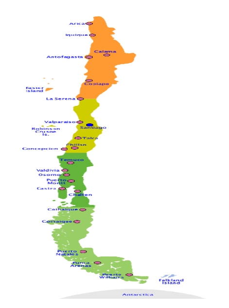
CASE STUDY OF SUCCESS OF CHILE’S AQUACULTURE The development of Chile's aquaculture was driven by favorable government policies, investment in research and development, and the adoption of modern farming techniques. As a result, between 1990 and 2016, Chile's aquaculture sector saw considerable growth, with salmon production contributing significantly to the country's economy. However, the rapid growth of the aquaculture industry in Chile has not been without challenges, including environmental impacts such as water pollution and the spread of diseases. |
Key Highlights of the report
- Proposed Hierarchy: The report outlines a structured framework to classify various sustainability levels within the Blue Economy model:
- Ocean/Brown Economy: This level includes all economic activities related to the ocean that mirror traditional marine industries such as shipping and fisheries. The primary focus here is on economic prosperity.
- Sustainable Blue Economy: This category integrates environmental sustainability and the protection of ecosystems. It goes beyond merely economic considerations to embrace conservation initiatives and the valuation of ecosystem services, in line with the UN Sustainable Development Goals.
- Regenerative Blue Economy (RBE): This highest tier strives to actively restore and revitalize marine ecosystems. It merges intensive regeneration efforts with sustainable economic practices, fostering prosperity while addressing climate change and biodiversity loss.
- Connections to Other Approaches: The report explores the connections between the Regenerative Blue Economy and various related concepts, including:
- Circular Economy: It advocates for the Blue Economy to embrace circular economy principles, emphasizing the reduction of waste and promoting the reuse and recycling of resources in marine environments.
- Bioeconomy: This involves utilizing marine-based biotechnology and biomass to foster a sustainable and regenerative economy within the Blue Economy framework.
- Social and Solidarity Economy: It stresses the importance of focusing on social justice, equitable distribution of resources, and empowering community-led projects within the Regenerative Blue Economy.
- Nature-based Solutions: The restoration and preservation of marine ecosystems are seen as crucial nature-based solutions for addressing societal challenges.
- Tracking Progress: The report discusses the challenges of measuring the effectiveness of the Blue Economy and proposes a set of benchmarks for different stages.
- “Brown” Blue Economy: Focuses on traditional economic indicators such as revenue and profitability.
- Sustainable Blue Economy: Incorporates environmental and social factors, including ecosystem health and the well-being of communities.
- Regenerative Blue Economy: Emphasizes criteria related to the restoration, revitalization, and equitable distribution of benefits.
Core Principles of RBE( Regenerative Blue Economy)
- Protection and Restoration: Concentrates on the protection and rejuvenation of marine and coastal ecosystems to address climate change and prevent biodiversity decline.
- Inclusive Economic System: Encourages an economic system that is fair and inclusive, enhancing resilience and improving overall well-being while reducing climate-related risks.
- Inclusive and Participatory Governance: Supports governance systems that are open and collaborative, incorporating adaptable legal and regulatory structures into global accords.
- Low or No Carbon Activities: Gives priority to economic practices that emit little or no carbon, thereby supporting the regeneration of marine ecosystems and enhancing community welfare.
- Focus on Island States: Emphasizes the importance of adopting RBE in island nations, taking into account the unique needs of coastal and Indigenous populations and honoring their cultural heritage.
- Spectrum of Sustainability: Acknowledges the varying degrees of sustainability within the Blue Economy, with RBE as the pinnacle, striving to actively rejuvenate ocean health, going beyond conventional sustainability efforts.
- Principles of Blue Economy: Highlights the core principles identified by various organizations, focusing on ecosystem vitality, long-term sustainability, inclusiveness, and effective governance.
- Blue Carbon and Nature-based Solutions: Stresses the significance of recognizing services provided by coastal and marine ecosystems, such as carbon capture, and points out Blue Carbon as a promising market opportunity that aligns with nature-based strategies for combating climate change and preserving biodiversity.
- Key Sectors and Considerations: Encourages sustainable practices in fisheries and aquaculture to avoid overfishing and ecosystem degradation, promoting artisanal fisheries and environmentally friendly aquaculture techniques. It also urges the maritime transport industry to switch to low or zero-emission fuels and technologies and supports the creation of Marine Protected Areas to balance out extractive operations.
Global Initiatives Promoting Regenerative Blue Economy
|
IUCN Nature 2030 |
Conservation efforts aligning with the United Nations 2030 Agenda for Sustainable Development and the post-2020 global biodiversity framework |
|
Great Blue Ball Initiative |
The African-led initiative aims to protect 30% of the ocean by 2030; achieve net gain of critical blue ecosystems such as mangroves, corals, seagrasses by 2030. |
|
Clean Sea Campaign |
UN Environment Programme (UNEP), campaign to tackle plastic pollution in the ocean |
|
Moroni Declaration and Cape Town Manifesto |
Highlight the importance of a RBE for the continent's development |
Indian Initiatives to Promote Blue Economy
|
Maritime Indian Vision 2030 |
Ten-year blueprint for the maritime sector aiming to boost waterways, shipbuilding industry and encourage cruise tourism in India. |
|
Deep Ocean Mission |
Initiative with an aim to develop technologies and capabilities for deep sea exploration. |
|
PM Samapdya Yojana |
Introduced as part of the AtmanIrbhar package to facilitate access to institutional credit and insurance coverage to fisherman. |
|
Integrated Coastal Zone Management |
Process for the management of the coast using an integrated approach, regarding all aspects of the coastal zone. |
|
India Norway Task Force on Blue Economy |
To mobilise relevant stakeholders from both Norway and India at the highest level, and ensure continued commitment and progress across ministries and agencies |
|
Blue Economy 2.0 |
Sustainable use of marine resources for exploration, economic growth and improved livelihoods. |
Lessons from Other Countries
- The strategies of Australia, China, and Mauritius illustrate their commitment to leveraging the sustainable ocean economy to meet their national development goals:
- In Australia, the Blue Economy is predominantly shaped by the offshore oil, gas, and aquaculture industries.
- In Mauritius, the greatest economic contributions come from coastal tourism and port-related activities.
- China's marine economy is driven by fisheries, tourism, and transportation sectors.
- For India, the marine services sector holds promise as a cornerstone of its Blue Economy. Consistent with the 'Digital India' and 'Make in India' campaigns, India is poised to prioritize marine ICTs, shipping and communication services, and establish a center of excellence for marine research and development. This approach will complement traditional sectors such as fisheries and coastal tourism.
Way Forward
- Regional attention has shifted to the Indian Ocean as a promising area for sustainable economic growth, with security also becoming a significant concern.
- India should capitalize on the momentum it has gained and assume a greater role in shaping and securing the Indian Ocean by developing concepts, norms, and roadmaps for a cooperative and inclusive ocean governance framework.
- Establishing a normative framework for conducting business and sustainably exploiting the ocean's resources is another area where India could take the lead.
- India should begin by establishing strong mechanisms for knowledge generation. For example, it could create various platforms for dialogue among sector-specific experts, professionals, scientists, and the business sector.
- Furthermore, existing and new multilateral trade agreements should be revised and structured to facilitate the development of sustainable infrastructure to support future economic activities.
Source :
https://www.iucn.org/news/202404/new-iucn-report-shows-way-toward-regenerative-blue-economy
Where to use :
Paper II ( Geography Optional ): Agriculture and allied activities
Paper I ( General Studies ): Resources
EXPANDING GLACIAL LAKES IN INDIAN HIMALAYAS
Why in news : The Indian Space Research Organisation (ISRO) recently released a satellite-data-based analysis shedding light on the expansion of glacial lakes in the catchments of Indian Himalayan river basins. This analysis comes amidst growing concerns about the risks of glacial lake outburst floods (GLOFs).
About :
Characteristics of Glacial lakes
- Size and Location: Glacial lakes vary in size, influenced by glacier size and activity, and are typically found in mountainous and polar regions with glaciers.
- Water Sources: Melting glacial ice, precipitation, and runoff are the primary water sources for glacial lakes.
Significance:
- Water Regulation: Glacial lakes regulate water flow in glacier-fed rivers, crucial for maintaining water availability, especially during dry periods.
- Biodiversity: Glacial lakes support unique aquatic species adapted to cold, high-altitude environments.
- Landscape Formation: They contribute to landscape evolution and the creation of landforms like cirques and tarns.
Ecological Challenges:
- Glacial Outburst Floods: Sudden water releases from glacial lakes, known as glacial lake outburst floods (GLOFs), pose significant risks to downstream communities and infrastructure, as seen in incidents like the Chamoli Disaster.
- Rapid Expansion: Increased glacier melting can lead to the rapid expansion of glacial lakes, raising the risk of flooding and landslides in surrounding areas
Insights from ISRO's Analysis:
- ISRO's analysis, which utilized satellite data spanning from 1984 to 2023, showed considerable growth in the size of glacial lakes across the Indian Himalayas.
- From the 2,431 lakes larger than 10 hectares recorded during 2016-17, 676 of these glacial lakes had significantly increased in size since 1984, with 601 lakes growing to over twice their original size.
- Notably, around 130 of these enlarged lakes are located in India, particularly within the river basins of the Indus, Ganga, and Brahmaputra, as a result of glaciers receding due to global warming.
1: Dimension- Risks and Challenges:
- Glacial lakes are crucial as freshwater reservoirs for rivers, yet they also present significant risks, such as Glacial Lake Outburst Floods (GLOFs), which can cause rapid and devastating floods downstream.
- The difficult terrain of the Himalayas adds to the challenge of monitoring these lakes, making satellite remote-sensing an essential tool for thorough monitoring and risk assessment.
2: Dimension- Mitigation Strategies:
The National Disaster Management Authority (NDMA) has published guidelines for managing disasters related to GLOFs. These strategies include:
- Identifying and mapping glacial lakes.
- Utilizing Synthetic Aperture Radar imagery to detect changes in water bodies automatically, including the formation of new lakes during the monsoon season.
- Developing methods for remote lake monitoring from space.
- Structurally managing lakes to reduce their water volume through techniques such as controlled breaching, pumping, or siphoning out water, and constructing tunnels through moraine barriers or beneath ice dams.
- Implementing solutions like using long High-Density Polyethylene (HDPE) pipes to siphon off water from lakes, which has been successfully employed to lower water levels in South Lhonak Lake in Sikkim.

Conclusion:
Thus, the ISRO study sheds light on the evolving dynamics of Himalayan glacial lakes, emphasizing the interaction of climate change, glacier retreat, and the expansion of these lakes. It underscores the necessity of adopting a comprehensive approach encompassing scientific research, policy measures, and community engagement to safeguard the environmental stability of the region and mitigate risks to downstream human populations.
Source :
https://www.isro.gov.in/Satellite_Insights_Expanding_Glacial_Lakes_Indian_Himalayas.html
Where to use :
Paper II ( Geography optional ) : Glacial lakes and floods , Climate change
Paper I ( General Studies ) : Water Bodies and Resources
WORLD’S DEEPEST BLUE HOLE DISCOVERED
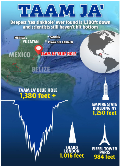
Why in news : Researchers have made a discovery in Mexico, uncovering the world’s deepest blue hole, known as Taam Ja’ Blue Hole (TJBH).
About :
- Blue holes, also referred to as Karst formations, are captivating geological features created by the slow dissolution of soluble rocks such as limestone or gypsum.
- Throughout millennia, ice age runoff slowly sculpted these vertical marine caves below the ocean's surface.
- The Taam Ja’ Blue Hole is a prime example of nature's extraordinary ability to shape intricate underwater landscapes through geological activity.
- This blue hole has garnered international interest from scientists due to its remarkable size and depth.
- A recent article in Frontiers in Marine Science discusses the astounding depth of the Taam Ja’ Blue Hole.
- Measurements from a scuba-diving expedition in December have established that the blue hole extends down to an impressive 1,380 feet (420 meters) below sea level, marking it as the deepest known blue hole on the planet.
- Outdoing the former deepest, the Sansha Yongle Blue Hole in the South China Sea, by 480 feet, the Taam Ja’ Blue Hole establishes a new standard in the field of underwater exploration.
Challenges of Exploration
- Despite technological progress, investigating the depths of the Taam Ja’ Blue Hole remains fraught with difficulties.
- The absence of oxygen and the presence of dangerous hydrogen sulfide gas pose significant risks for researchers trying to explore its deepest parts.
- Even utilizing advanced equipment such as echo-sounders and CTD ( Conductivity , Temperature and Depth ) profiles, scientists have not managed to reach the bottom of the blue hole.
Ongoing Scientific Endeavors
- First identified in 2021, initial probes using echo-sounders revealed just a part of the Taam Ja’ Blue Hole’s depth, measuring up to 900 feet.
- A more recent expedition, armed with advanced technology like the sophisticated CTD profile, yielded deeper insights into the blue hole’s conditions.
- Despite these technological advances, the researchers could not reach the base, as their equipment’s cable extended only to 1,380 feet. Scientists speculate that the bottom might contain a complex maze of caves and tunnels, which remains unexplored.
Future Exploration and Discoveries
- Despite the obstacles, scientists are steadfast in their resolve to decode the secrets of the Taam Ja’ Blue Hole.
- Upcoming missions seek to surpass technological barriers and delve further into the depths, illuminating the unknown regions beneath the ocean's surface.
- Every expedition offers the chance for novel findings, enhancing our knowledge of Earth’s geological features and the intricacies of marine ecosystems.
Yucatan peninsula:
- The Yucatán Peninsula is a vast region located in southeast Mexico, extending into parts of Belize and Guatemala.
- It stretches to the northeast, dividing the Gulf of Mexico on the north and west from the Caribbean Sea to the east.
- The Yucatán Channel, which lies between the peninsula's northeastern tip and Cuba, links these two bodies of water. Covering an area of about 181,000 square kilometers (70,000 square miles), the peninsula features a flat terrain and is predominantly made up of porous limestone.
Source :
https://www.bbc.co.uk/newsround/articles/cxe91dv8kgvo
Where to use :
Paper I ( Geography Optional ) : Geomorphology
Volcanic vortex rings
Volcanic vortex rings: Vortex rings are generated when gas, predominantly water vapour, is released rapidly through a vent in the crater.The vent that has opened up in volcano’s crater is almost perfectly circular, so the rings that have been seen are also circular.Volcanic vortex rings were first observed at Etna in 1724 and have since been documented at various volcanoes worldwide.These rings can remain in the air for up to 10 minutes but tend to disintegrate quickly if conditions are windy and turbulent.
Primary Forest
Primary Forest : Primary forests are characterized by their dense coverage of native tree species, minimal human interference, and undisturbed ecological processes. They store more carbon and support greater biodiversity compared to other forest types. Therefore, their loss is nearly irreversible, as secondary forests cannot match their biodiversity and carbon sequestration capabilities. According to the Food and Agricultural Organization (FAO), primary forests account for approximately one-third (34%) of the world's forested land.
North Atlantic Blob
North Atlantic Blob : It is a cold patch located south of Iceland and Greenland.This cold patch was most prominent during the winter of 2014-2015 when the sea surface temperature was about 1.4 degrees Celsius colder than normal.
Climate Clock
Climate Clock : The Climate Clock was launched in 2015 to provide a measuring stick against which viewers can track climate change mitigation progress. The Climate Clock is a graphic to demonstrate how quickly the planet is approaching 1.5 °C of global warming, given current emissions trends. It also shows the amount of CO2 already emitted, and the global warming to date. The clock is updated every year to reflect the latest global CO2 emissions trend and rate of climate warming.
Chloride Mass Balance
Chloride Mass Balance : It is a tracer technique that estimates long-term groundwater recharge rates in arid and semi-arid environments. It's considered the most reliable method for estimating recharge because of it's conservative nature.
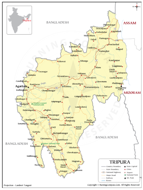
REJUVENATION OF KUMARITILLA LAKE , AGARTALA
Kumaritilla Lake is part of the Sadar Sub-Division of West Tripura District. Following are causes of degradation of lake:
- Organic pollution from anthropogenic activities and human settlements on all sides of the lake in the past 40 years.
- Discharge of untreated or inadequately treated sewage
- Dumping of solid wastes without restriction
- Dumping of construction and demolition wastes, and plastic wastes
- Inflow of waste water containing effluents from workshops and other establishments.
- For restoration of Kumaritilla Lake , water plants viz. hyacinth/duckweeds /kachuripana / jalkumbhi along with several grasses, bushes and trees were cleared using mechanical devices
- De-Silting of the lake was done using excavator, tipper, loader, etc
- Outlets were constructed for overflowing of water from the lake.
- A water fountain is also installed in the center of the lake for aeration with a view to increase the oxygen (DO) level of the lake.
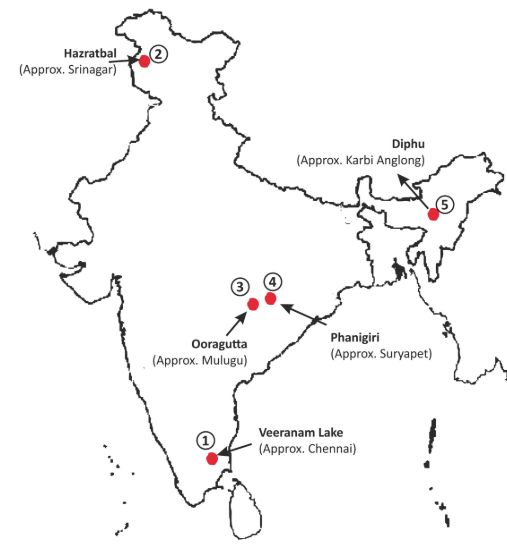
Places in the news
1. Veeranam Lake
Why in news : According to data from the Chennai Metropolitan Water Supply and Sewerage Board (CMWSSB), Veeranam Lake, a primary water source for Chennai has dried up.
- It is located in Cuddalore district in the state of Tamil Nadu in South India, 1 km from Kattumannarkoil.
- It is one of the water reservoirs from where water is supplied to Chennai city.
- The lake was built in the 10th century during the time of Greater Cholas (907–955 CE).
2. Hazratbal
Why in news : Recently, the famous Hazratbal Dargah in Srinagar is attracting locals for a rare spectacle of the washing and clipping of the largest carpet woven in Kashmir so far.
- It is situated on the left bank of the famous Dal Lake.
- The Hazratbal Shrine holds relevance to Muslims as it is believed to preserve 'Moi-e-Muqqadas' – the sacred hair of Prophet Muhammad's beard.
- Approx. Srinagar
3. Ooragutta
Why in news : Recently, three new archaeological sites were discovered in Telangana by a team of archaeologists led by Prof. K.P. Rao.
- The place is in the Mulugu district of Telangana, India, near Bandala village.
- The site boasts over 200 megalithic monuments, although the exact count remains uncertain due to the dense forest and hilly terrain.
- They are characterized by squarish or rectangular shapes, the structures at Ooragutta exhibit unique features.
- Approx . Mulugu
4. Phanigiri
Why in news : Recently, Telangana’s Department of Heritage discovered a hoard of 3,730 lead coins in an earthen pot at Phanigiri, a renowned Buddhist heritage site located 110 km away from Hyderabad.
- It is a village in Suryapet district of Telangana.
- It is closely related to the stupa complexes at Amaravati and Nagarjunakonda.
- Previously the name of the village is Dharmachakrapuram but later it is changed to Phanigir.
- Approx. Suryapet
5. Diphu :
Why in news : Recently, in Assam's predominantly tribal Diphu Lok Sabha constituency, candidates from all political parties have pledged to implement Article 244(A) of the Constitution, aiming to establish an autonomous 'state within a state.'
- Diphu is the headquarter of Karbi Anglong district in the state of Assam in India.
- This small town is a popular tourist hill station for people of nearby cities.
- The town is home to many indigenous communities like Dimasa Kachari, Karbis and Rengma etc.
- Approx : Karbi Anglong
Fortnightly KOSMOS MCQs Practice
Q1. Which of the following are the features of Pacific Ring of Fire?
Statement-I: The Ring of Fire, a horseshoe-shaped area encircling the Pacific Ocean, hosts over 450 volcanoes, constituting about 75% of Earth's total volcanic activity.
Statement-II: The high frequency of volcanic eruptions and seismic activity in the Ring of Fire is primarily attributed to the significant movement of tectonic plates in the region.
Which one of the following is correct in respect of the above statements?
- Both Statement-I and Statement-II are correct and Statement-II is the correct explanation for Statement I
- Both Statement-I and Statement-II are correct and Statement-II is not the correct explanation for Statement-I
- Statement-I is correct but Statement-II is incorrect
- Statement-I is incorrect but Statement-II is correct
Q2. Consider the following statements regarding Cicadas :
- Cicadas, members of the order Hemiptera and the superfamily Cicadoidea, are not mammals but insects.
- Most of their lives are spent underground, with emergence from the soil primarily occurring for mating purposes.
- India and Bangladesh boast the highest global ranking in terms of the genetic diversity of cicadas, followed by China.
Which of the following statements is/are correct?
- 1 only
- 1, 2 and 3
- 2 and 3
- 1 and 2
Q3. Consider the following statements regarding Artificial reefs:
- These are structures built by humans through biorock technology and are placed on the seabed in freshwater or saltwater environments.
- There are no artificial reef installations within India's waters.
Which of the following statements is/ are not correct?
- 1 only
- 2 only
- Both 1 and 2
- Neither 1 nor 2
Q4. With reference to the Volcanic vortex rings, consider the following statements:
- The Observations of volcanic vortex rings have been reported at Mount Etna.
- These rings are formed when gas, primarily water vapor, is swiftly released through a vent in the crater.
- It is situated on the eastern coast of Sicily, Italy, Mount Etna rises from the Mediterranean Sea.
How many of the statements given above are correct?
- Only One
- Only Two
- All Three
- None
Q5. With reference to the Baltimore Port, Consider the following statements:
- Port of Baltimore is located along the shores and branches of the Patapsco River.
- The Francis Scott Key Bridge was a steel arch bridge that stretched across the lower Patapsco River and outer Baltimore Harbor/Port.
Which of the following statements is/are correct?
- 1 only
- 2 only
- Both 1 and 2
- Neither 1 nor 2
Q6. Consider the following statements:
- The Andaman Islands and the Nicobar Islands are separated by the Ten Degree Channel.
- Located on Little Nicobar Island, Indira Point denotes the southernmost extremity of India.
Which of the statements given above is/are correct?
- 1 only
- 2 only
- Both 1 and 2
- Neither 1 nor 2
Q7. Consider the following statements regarding the Intergovernmental Panel on Climate Change (IPCC):
- The IPCC, a United Nations organization, was founded in 1988 through collaboration between the World Meteorological Organization and the World Bank.
- According to findings in the IPCC Sixth Assessment Report, there is a projection of a one-meter rise in the global mean sea level.
Which of the above statements are correct?
- Only one
- Only two
- Both
- None
Q8. Consider the following statements:
Statement-I: Indonesia holds considerable sway in the global climate crisis as it leads in coal and palm oil exports.
Statement-II: Indonesia is strategizing to move its capital from Jakarta to Borneo due to severe congestion, pollution, and rapid subsidence, which could inundate a substantial part of the city by 2050.
Which one of the following is correct in respect of the above statements?
- Both Statement-I and Statement-II are correct, and Statement-II is the correct explanation for Statement-I.
- Both Statement-I and Statement-II are correct, and Statement-II is not the correct explanation for Statement-I.
- Statement-I is correct, but Statement-II is incorrect.
- Statement-I is incorrect, but Statement-II is correct.
Q9. Consider the following statements with respect to ‘Veeranam Lake’:
- It was considered one of the world's longest man-made lakes, spanning 14 kilometers in length.
- Veeranam derives its source from the Kollidam River, which serves as the northern distributary of the Cauvery River.
- It was constructed between 907 and 955 AD, the reservoir was commissioned by Chola Prince Rajaditya Chola.
How many of the above statements are not correct?
- Only one
- Only two
- All three
- None
Q10. Consider the following statements:
Statement-I: The National Disaster Management Authority (NDMA) and State Disaster Management Authorities (SDMAs) were established under the Disaster Management Act, 2005.
Statement-II: States have access to disaster relief funds from two avenues: the State Disaster Relief Fund (SDRF) and the National Disaster Relief Fund (NDRF).
Which one of the following is correct in respect of the above statements?
- Both Statement-I and Statement-II are correct, and Statement-II is the correct explanation for Statement-I.
- Both Statement-I and Statement-II are correct, and Statement-II is not the correct explanation for Statement-I.
- Statement-I is correct, but Statement-II is incorrect.
- Statement-I is incorrect, but Statement-II is correct.
Q11. With reference to Cloud Seeding, consider the following statements:
- Static Cloud Seeding entails the introduction of ice nuclei like silver iodide or dry ice into cold clouds.
- Dynamic Cloud Seeding involves dispersing fine particles such as salts via flares or explosives into the base of warm clouds.
- Hygroscopic Cloud Seeding is a technique aimed at stimulating rainfall by enhancing vertical air currents.
How many of the statements given above are correct?
- Only one
- Only two
- All three
- None
Share the article
Edukemy’s Current Affairs Quiz is published with multiple choice questions for UPSC exams
MCQ
Get Latest Updates on Offers, Event dates, and free Mentorship sessions.

Get in touch with our Expert Academic Counsellors 👋
FAQs
Geography Current Affairs focuses on the contemporary issues, events, and developments in the field of geography. It covers recent geographical phenomena, environmental changes, geopolitical shifts, and related news. This differs from regular geography studies which may focus more on foundational concepts, historical contexts, and theoretical frameworks.
Updates are provided regularly to ensure that subscribers stay informed about the latest developments in geography. Typically, updates are provided on a fortnightly basis, depending on the frequency of significant events and changes in the field.
Absolutely. Geography Current Affairs serves as a valuable resource not only for Geography optional but also for GS papers, especially GS Paper 1 (covering Indian Heritage and Culture, History, and Geography of the World and Society) and GS Paper 3 (covering Technology, Economic Development, Biodiversity, Environment, Security, and Disaster Management). It aids in building a holistic understanding of various topics and strengthens answer-writing skills by incorporating contemporary examples and perspectives.
Geography Current Affairs holds immense importance for UPSC preparation, particularly for aspirants opting for Geography optional. It helps candidates stay updated with the latest developments, geographical phenomena, environmental issues, and geopolitical shifts worldwide, aligning them with the dynamic nature of the subject as tested in the UPSC examinations.


