20 Nov
Vicious trap of food insecurity & conflicts-urgent need for fulfilling SDG goals
- In news: The 2021 Global Report on Food Crises (GRFC 2021) highlights high number of people in Crisis in 55 countries/territories, driven by persistent conflict, pre-existing and COVID-19-related economic shocks, and weather extremes.
- Background: Relationship between food, hunger, peace and conflict highlights the existence of “conflict trap”.
- More than half of all food insecurity people live in countries affected by conflict.
- At the end of 2020, more than 88 million people were suffering from acute hunger due to conflict and instability - a 20 percent increase in one year.
- Thus, together, conflict and food insecurity can create a vicious cycle, wherein conflicts lead to food scarcity, food scarcity leads to market disruptions, which lead to further decreases in food availability and greater disruptions.
- Also, the Sustainable Development Goals (SDGs) have an intrinsic relationship to peace and stability. Without peace, all other goals—from focusing on youth and women's needs, to addressing climate change and water, energy and food security—will be impossible to achieve.
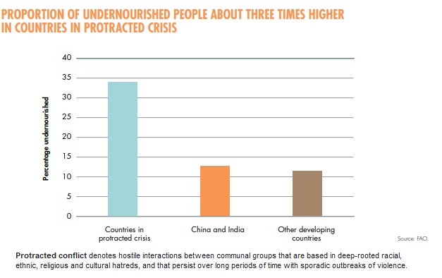
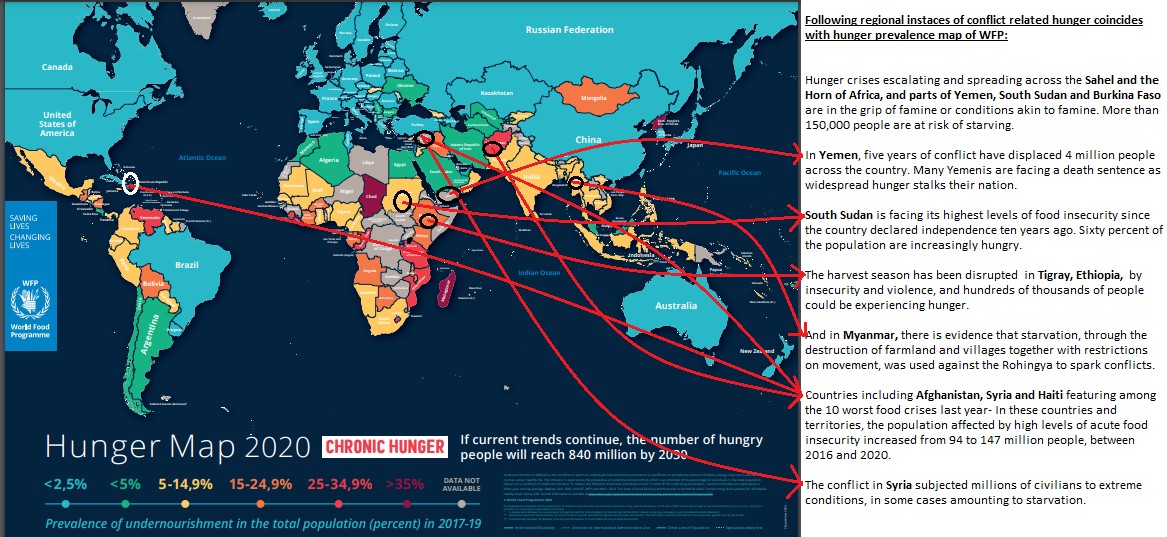
- Regional pattern of food insecurity and hunger coincides positively with conflict prone regions of the world: Famine and hunger are no longer about lack of food. They are now largely man-made and are concentrated in countries affected by large-scale, protracted conflict.
- Vicious trap of food insecurity and conflict-
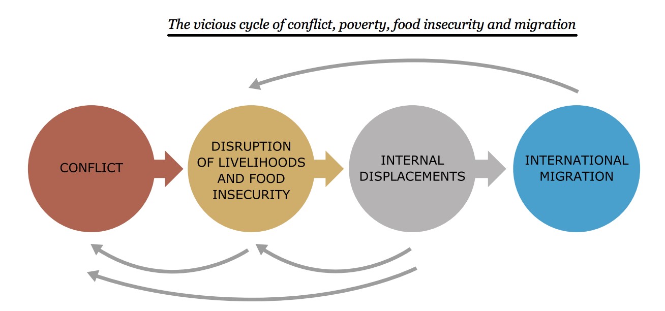
-
- The impacts of violent conflict on food security:
Conflict entails enormous and multifaceted costs. Most conflicts affect rural areas and their populations, with heavy impacts on agricultural production and rural livelihoods. This is particularly true for civil conflicts, which in recent years have become the most common form of armed conflict. These have following impact on food security:
-
-
- Conflict destroys land, water, biological, and social resources for food production (challenges to SGD 2 and SDG 12).
- Violent conflicts are also a driver of forced displacement further weakening food security in both countries of origin (where labor may be in short supply and rural markets collapse) and many host communities (which may face pre-existing strong pressure on limited arable land) (hampers- SDG1, SDG2, SDG3, SDG8, SDG10 and SDG 16).
-
The war in Syria, for instance, has caused more than 6 million people to flee their homes to other locations in the country, where they face severe food insecurity, while another 5 million people have fled to neighboring countries and beyond (UNHCR, 2018).

More than 77 million acutely food-insecure people live in country where conflict is main driver. Also, conflict is one of the biggest drivers of famines.
Example: More than 34 million people are currently on the very edge of famine and risk starvation, up from 27 million people in 2019, in conflict prone regions such as: Afghanistan, the Central African Republic, the Democratic Republic of the Congo, Ethiopia, Haiti, Honduras, Nigeria, South Sudan, Sudan, Uganda, Venezuela, Yemen and Zimbabwe.
As a result, mortality caused by conflict through food insecurity and famine can far exceed deaths caused directly by violence. Between 2004 and 2009 approximately 55,000 people a year lost their lives as a direct result of conflict or terrorism. In contrast, as a result of famine caused by drought and conflict, more than 250,000 died in Somalia alone between 2010 and 2012.
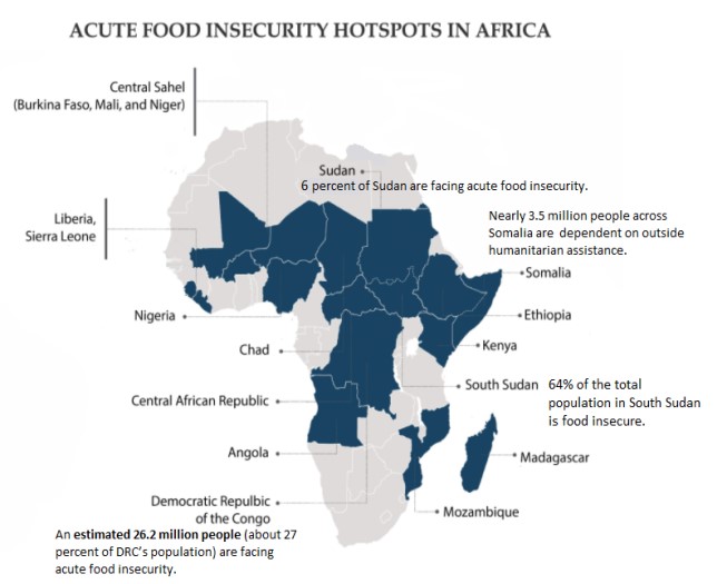
Case study: Conflict continues to be the primary driver of acute food insecurity in the African continent. Twelve out of the 15 African countries facing the greatest food insecurity presently are also experiencing conflict.
- The Democratic Republic of Congo (DRC) is experiencing “one of the worst humanitarian crises in the world”-primarily because of ongoing armed violence and inter-communal conflicts in the eastern and north eastern regions of the country .
- Somalia has experienced year after year of acute food insecurity largely due to conflict, population displacement, and disruptions in food production and transportation.
- Not only does conflict cause death and destruction, it also leads to mass displacementin countries such as Mozambique, Ethiopia, and northeastern Nigeria, further exacerbating food insecurity.
- The impacts of food (in) security on violent conflicts: Achieving SDG 16 is a major challenge in regions where food insecurity perpetuates conflict, as it drives people from their homes, lands and jobs, deepening existing fault lines and fueling grievances.

-
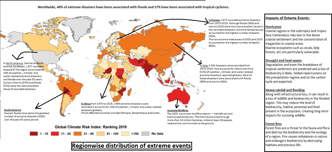
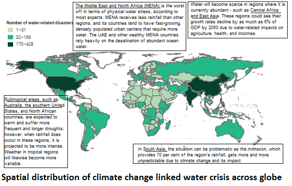
- Climate change ->food insecurity -> conflict:
- Temperature-induced variation in agricultural yield can alter migration patterns, with potential effects on sub-state violence and conflict.
- Excessive heat may also reduce the broader supply of crops by impacting cropping patterns and productivity adversely, raising the price of food and ultimately conflicts.
- Temperature anomalies also have effects on economic activity beyond agricultural production- temperatures may depress economic output and growth, which may lead to conflicts.
- Climate change ->food insecurity -> conflict:
- Way forward for sustainable development in conflict prone regions:
- To achieve peaceful and inclusive societies (SDG 16) - It aims aim to significantly reduce all forms of violence, and work with governments and communities to end conflict and ultimately food insecurity.
- End hunger, achieve food security and adequate nutrition for all, and promote sustainable agriculture (SDG 2): Food security interventions can reduce the risk of, and address root causes of, violent conflict. It can support the development of capacities and public administration systems.
For example: In Nepal, the establishment of a nation-wide food security monitoring system, supported by WORLD FOOD PROGRAMME, has helped the government respond to food insecurity and contributed to the legitimacy of the state and strengthened state-society relations
-
- Improve the sustainability of livelihood systems and food security outcomes. For example, the rehabilitation and management of water resources by different ethnic groups in Kyrgyzstan contributes to multi-ethnic reconciliation and addresses underlying drivers of conflict, including resource scarcity and ethnic tensions.
- Closing the gender gap in agriculture would generate significant gains for the agriculture sector and help build peaceful and inclusive societies (SDG 5): Targeting women as the first beneficiaries of food aid and social protection, as well as helping them and their communities complete harvests, can therefore contribute significantly to improving household resilience and to peace building.
Where it can be used:
Geography- P1 (Perspective in human geo, Economic geo, Population geography, Regional planning), P2 (Cultural setting, Political Aspects, contemporary)
GS- GS2 (issues related to poverty and hunger), GS3 (food security, security).
Tags- UPSC, Geography optional, GS, food security, food insecurity, GS2, GS3.
Source:
Bauxite mining at Mali Hills-Reasons for protests by local tribes
Brief Background:

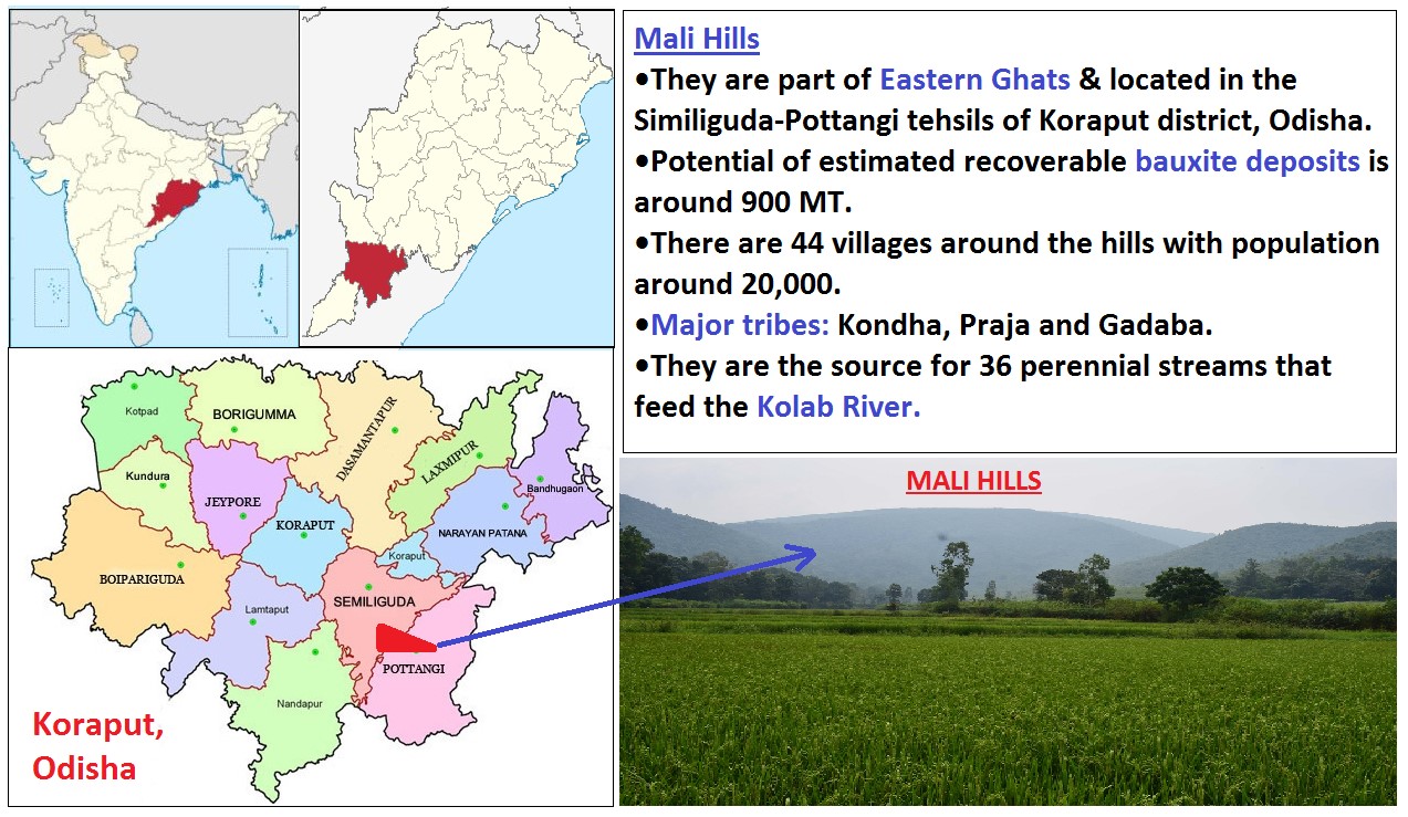
Reasons for the protests by local tribes:
Local tribes are protesting because of potential and perceived impacts of bauxite mining in the region. Such as:
- Impact on agriculture: Due to bauxite mining, soils in the region will be exposed to toxic chemicals like bauxite refinery residue (BRR) or red mud which will lead to soil contamination and land degradation. This will impact agricultural productivity and further hurts the livelihood opportunities of people in the region.
- Changes in land-use pattern: Due to deforestation, removal of vegetation and other mining activities such as excavation, overburden dumping etc. will lead to dramatic changes in land-use patterns.
- Impact on water resources: Over 36 water sources will get dry and farmland of more than 40 villages of Similiguda block will be affected if mining operations start at Mali Hills.
- Environmental pollution: Mining activities will lead to air pollution, noise pollution and contamination of the water bodies in the region due to run-off from mine tailings and unsafe sewage disposal.
- Conflicts: Due to competition between local tribes and migrant workers for accessing fuel, firewood, fodder and water resources.
- Widening gender inequality: The plight of women is worsening as they have reported an increase in domestic work hours since the disappearance of the forest, shrubs, bushes and contamination of water sources resulting from bauxite mining.
- Impact on social well-being: Bauxite occupational exposure affects the health of miners, and has negative consequences on the health of surrounding communities, such as increased respiratory symptoms, contamination of drinking water, other potential health risks from ingestion of bauxite and heavy metals, including noise-induced hearing loss and mental stress.
- Impact on biodiversity: The hill is home rich fauna and flora including several medicinal trees. It is also an elephant corridor which will get affected by the bauxite mining.
Way forward:
- Sustainable bauxite mining: According to ‘Fourth Sustainable Bauxite Mining report 2008’, this involves practices like Mine rehabilitation, soil management and flora & fauna protection to make bauxite mining more sustainable and land area footprint neutral.
Case Study: Bauxite Mine Rehabilitation in Brazil
• The Mineração Rio do Norte (MRN) mine in the Amazon has a very sophisticated rehabilitation program in place which includes an epiphytes project that involves the rescue, classification and multiplication of a variety of epiphytes (araceae, bromeliads and orchids).
• The epiphytes are collected in clearing areas, maintained in plant nurseries and then introduced to the rehabilitation area after reforestation was successful and reached a mature state.
- Measures such as Land reclamation, rehabilitation of communities affected by mining, afforestation and safe mining waste disposal.
Where it can be used?
It can be used in topics related to Paper 1 (Environmental Degradation, Sustainable development), Paper 2(Hill and tribal area development, Water shed development, Changes in patterns of land use) and GS3 (Environmental Degradation).
Tags: UPSC, Geography, Optional, Bauxite Mining, Mali Hills, Koraput, Tribal protests, Impacts of bauxite mining.
Sources:
Agri tourism prospects in India
In News
Kerala government recently launched the Kerala Agri Tourism Network-Farm Tourism.
What is agri-tourism?
- World Tourism Organization (1998) defines agri-tourism as “it involves accommodation being offered in the farmhouse or in a separate guesthouse, providing meals and organizing guests’ activities in the observation and participation in the farming operations.”
- Agro-tourism refers to people visiting working farms or other agricultural operations for the purpose of enjoyment, education, or other active involvement.
- Agro-tourism encompasses a wide variety of activities and provides a means for farmers to diversify and supplement their income. Such activities may include wildlife study, horseback riding, cannery tours, cooking classes, wine tasting, harvest festivals, barn dances, farm stays, guided tours, and petting zoos.
Evolution and Development of Agri Tourism
- The term agro-tourism emerged in the late twentieth century. This concept was initiated and developed in Europe and North America, then developed in many countries.
- In India it was initiated in 2005 at Malegaon village, near Baramati, Maharashtra by Agri Tourism Development Corporation (ATDC).
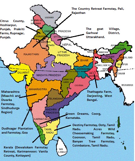
- Major Agro-tourism Destinations in India: Some of the famous and major agro-tourism destinations in India are as under:
Scope and Potential of Agri Tourism in India
At present Agriculture is the primary source of livelihood for about 58% of India’s population. Share of agriculture and allied sectors in gross value added (GVA) of India at current prices stood at 17.8 % in FY20. This offers a huge scope of Agri Tourism in India.
Benefits of Agri Tourism in India
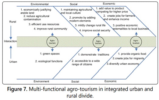
Following are the key drivers of tapping the scope of developing the agri tourism in India-
- Supply Side Drivers
- Expanse of Agriculture: India has the second-largest arable land resources in the world. With 20 agri-climatic regions, all 15 major climates in the world exist in India. The country also possesses 46 of the 60 soil types in the world.
- Diversity of crops: India is the largest producer of spices, pulses, milk, tea, cashew and jute, and the second-largest producer of wheat, rice, fruits and vegetables, sugarcane, cotton and oilseeds. India also has the largest livestock population of around 535.8 million, which translated to around 31% of the world’s livestock population in 2019.
- Diverse physiographic condition: India encompasses vast coastline, river valleys, mountain valleys, plains and islands. These provide ample opportunity for growth of agri tourism in the country. E.g., Kashmir valley for saffron cultivation, Araku valley coffe plantation, Kuttanad Below Sea-level Farming System (KBSFS) for heritage agri tourism
- Demand Side Drivers
- Large population and rising urban and rural income have added to growth in demand for agri tourism.
- Changing lifestyle and increasing expenditure on health and nutritional foods have also added to growth.
- The rising pollution in urban centers is creating a necessity for longer period stays in rural areas.
- The demand for sustainable tourism also promoting the agri tourism.
- Policy Support Driver
- Thrust on rural infrastructure- Government is driving various schemes such as PMGSY, BharatNet etc to enhance the connectivity and ease of access to remote rural areas. Various other schemes facilitating various basic amenities such as Swacchh Bharat Mission (Gramin), Jal Jeevan Mission and Health and Wellness centres etc. will further boost the support to agri tourism prospects.
- Campaigns such as Swadesh Darshan, a theme-based tourist circuit was launched to harness the tourism industry’s potential. It involves a component of Rural tourism which includes the Agri tourism.
- Government recently came up with the Draft National Strategy & Roadmap for Development of Rural Tourism in India which mentions the development of agri tourism.
- Various states like Maharashtra have dedicated policies for the development of agri tourism.
Challenges of Agri tourism in India

Agri-tourism can fuel rural economies through the multiplier effect and the acquired benefits will be shared amongst different businesses within the community. Further development of agri-tourism leads to profit margins for farm products and services, particularly for small farms in crisis.
Where it can be used: Geography- P1 ( Economic geo, Population geography,P2 (Agriculture, contemporary)
Sources:
Bomb Cyclone - Edukemy Current Affairs
Explosive cyclogenesis (also referred to as bomb cyclone) is the rapid deepening of an extra-tropical cyclonic low-pressure area. This is a predominantly maritime, winter event, but also occurs sometimes in the summer.
- Regions associated with “bomb cyclones”:
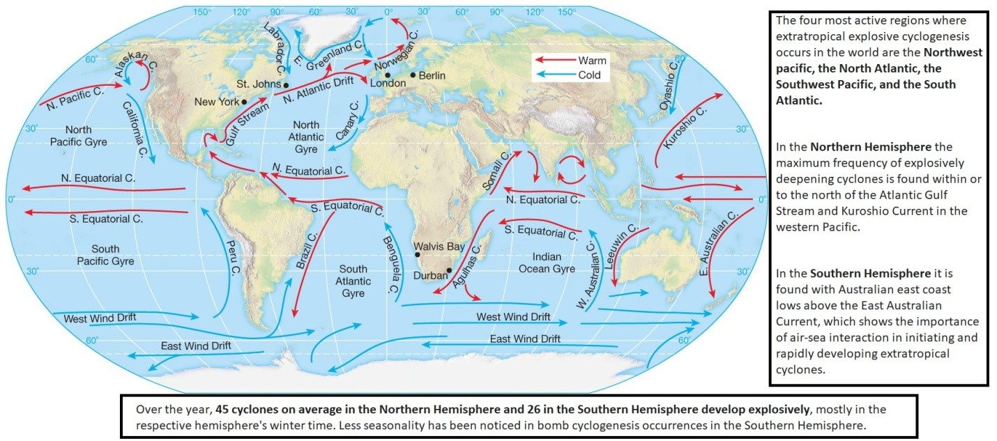
- Formation Mechanism involved in formation: : A bomb cyclone forms when air pressure rapidly drops as the storm explosively strengthens. And typically, the lower the pressure, the stronger the storm.
- Baroclinic instability has been cited as one of the principal mechanisms for the development of most explosively deepening cyclones.
- Other factors include
- The relative position of trough and thickness patterns,
- Deep tropospheric frontogenetic processes which happen both upstream and downstream of the surface low,
- The influence of air–sea interaction, and
- Latent heat release.
- This process is the extratropical equivalent of the tropical rapid deepening. Although their cyclogenesis is entirely different from that of tropical cyclones, bomb cyclones can also produce winds of 120 to 155 km/h and yield heavy precipitation.
Tags- UPSC, geography optional, GS, cyclone, bomb cyclone.
Links:
POSHAN Abhiyaan
- The Prime Minister’s Overarching Scheme for Holistic Nourishment (POSHAN Abhiyaan), or the National Nutrition Mission. It was launched in 2018 with the motto ‘Sahi Poshan Desh Roshan’.
- Objective: to improve nutritional outcomes for children, adolescents, pregnant women and lactating mothers by leveraging technology, a targeted approach and convergence and finally to ensure malnutrition free India by 2022.
- How it is different? Earlier there were a number of schemes directly/indirectly affecting the nutritional status of children (0-6 year's age) and pregnant women and lactating mothers. In spite of these, level of malnutrition and related problems in the country is high mainly because of lack of synergy among them.
- POSHAN Abhiyaan through robust multi-ministerial convergence mechanism and other components would strive to create the synergy.
- Key strategies and interventions: IYCF (Infant and Young child feeding), Food and Nutrition, Immunization, Institutional Delivery, WASH (Water, Sanitation and Hygiene), De-worming, ORS-Zinc, Food Fortification, Dietary Diversification, Adolescent Nutrition, Maternal Health and Nutrition, ECD (Early childhood development)/ECCE (Early Childhood care and Education), Convergence, ICT-RTM (Information and Communication. Technology enabled Real Time Monitoring) and Capacity Building.
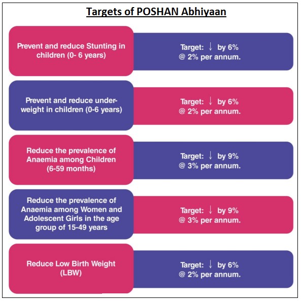
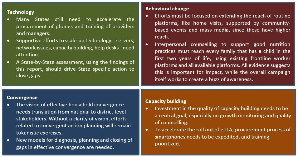
In 2020, NITI Aayog’s report titled” Accelerating Progress on Nutrition in India: What Will It Take” gave recommendations for strengthening key POSHAN Abhiyaan pillars. They are:
Herringbone drainage Pattern
- What is it?
The term herringbone has been derived from the pattern of bones of herring fish (mainly spine bones). Also known as rib pattern, it is developed in mountains areas where broad valleys are flanked by parallel ridges having steep hill-slide slopes.
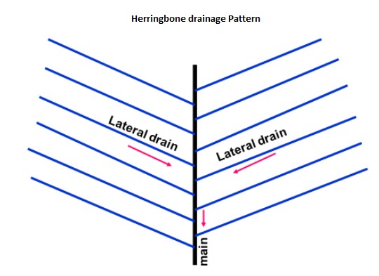
- How does it develop?
The longitudinal consequent streams, as master streams are developed in the longitudinal parallel valley while tributaries, as lateral consequent, after originating from the hill-slopes of the bordering parallel ridges join the longitudinal consequent almost at right angle. The course of the tributaries are straightened because of slope factor with little distance between the ridges and the longitudinal consequent occupying the valley and thus the tributaries are not allowed to adopt sinuous course and join the longitudinal consequent at right angles.
- Examples:
- The upper Jhelum river in the Vale of Kashmir receives numerous tributaries from the side and thus forms herringbone drainage pattern.
- The rivers occupying east-west trenches in the Himalayas from herringbone pattern. The Tamar Kosi, a left bank tributary of Kosi river, the upper Rapti (tributary of Ghagra river), etc have such drainage patterns.
Tags: UPSC, geography, optional, GS, Drainage Pattern.
Sources:
Role of Handlooms in Rural area development: Himachal Pradesh
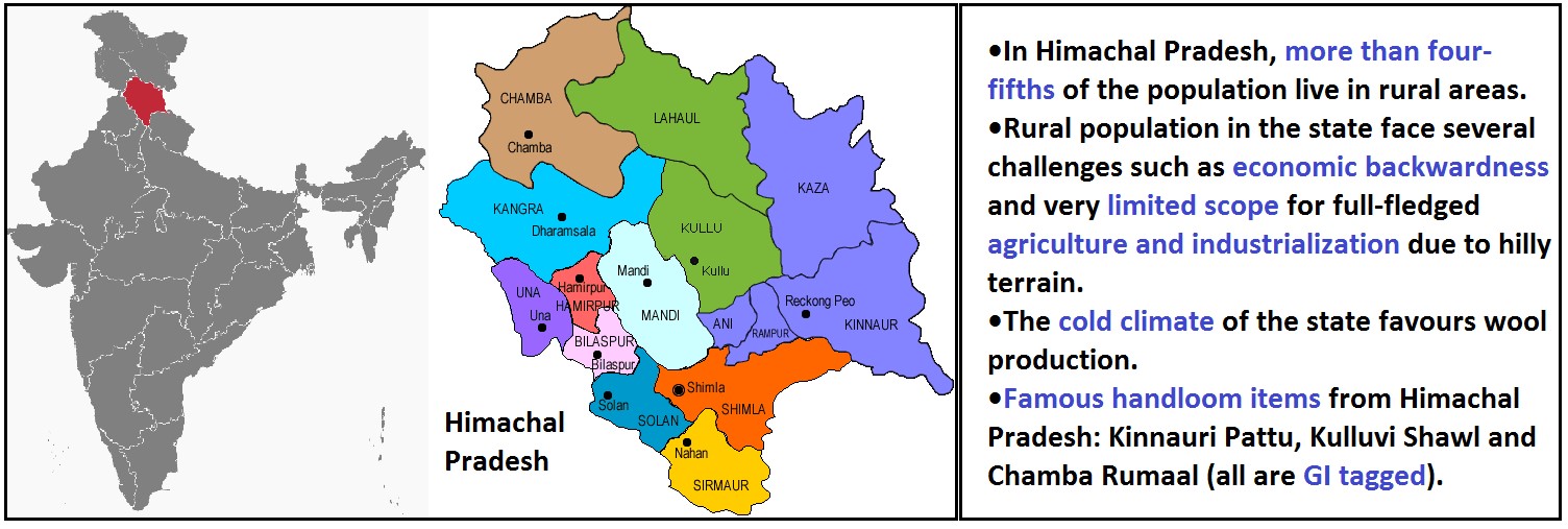
Several measures taken by Himachal Pradesh for the promotion of Handloom sector in rural areas:
- Integrated Handlooms Development Scheme: From 2014-2015 funds were being released under Comprehensive Handlooms Development Scheme (CHDS), component of National Handloom Development Programme (NHDP).
- Cluster Development Programme: Block-level cluster approach has been adopted for development of handlooms. This provides for integrated and holistic development of cluster by implementing need-based interventions.
- Establishment of societies and corporations: Such as Himachal Pradesh State Handicrafts & Handloom Corporation Limited for the promotion of handloom industry by imparting training to weavers/artisans, to improve their skills in weaving and also provide financial and raw materials assistance.
- Marketing and Export Promotion Scheme: For facilitating marketing of handloom products, exports, brand recognition and development of market infrastructure.
- Handloom Weavers’ Comprehensive Welfare Scheme: For providing Life, accidental and disability insurance coverage to handloom weavers/workers under the components PMJJBY, PMSBY and MGBBY. (PMJJBY-Pradhan Mantri Jeevan Jyoti Bima Yojana, PMSBY-Pradhan Mantri Suraksha Bima Yojana, MGBBY-Mahatma Gandhi Bunkar Bima Yojana).
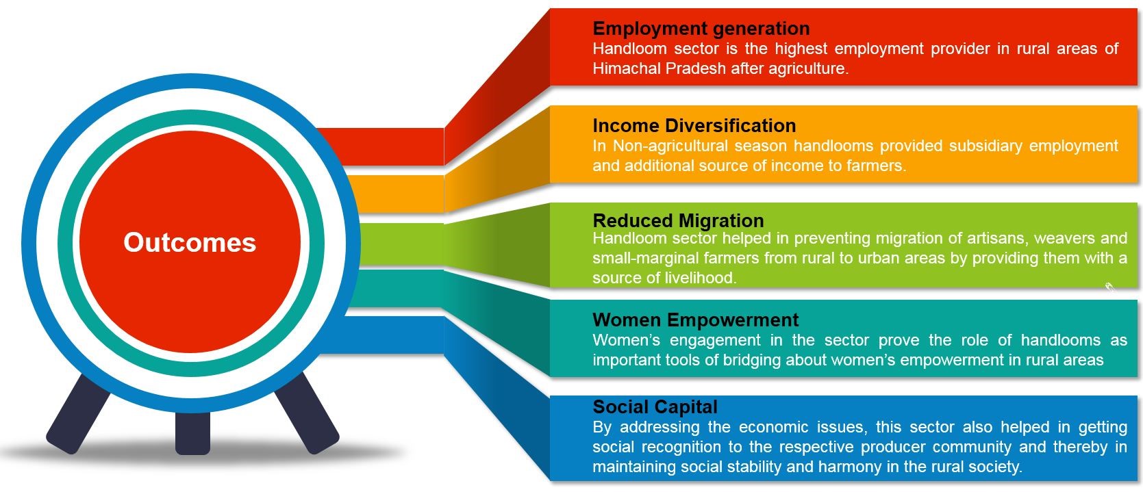
This can be replicated in other wool producing states like Rajasthan, Haryana and Union territory of Jammu & Kashmir etc.
Where it can be used?
It can be used in topics related to Paper 2 (Agriculture, Rural area development, Hill area development, Migration), GS1 (Social Empowerment) and GS 3 (Agriculture).
Tags: UPSC, Geography, Optional, Case Study, Hand loom sector, Himachal Pradesh, Rural area development.
Sources:
Places in news
|
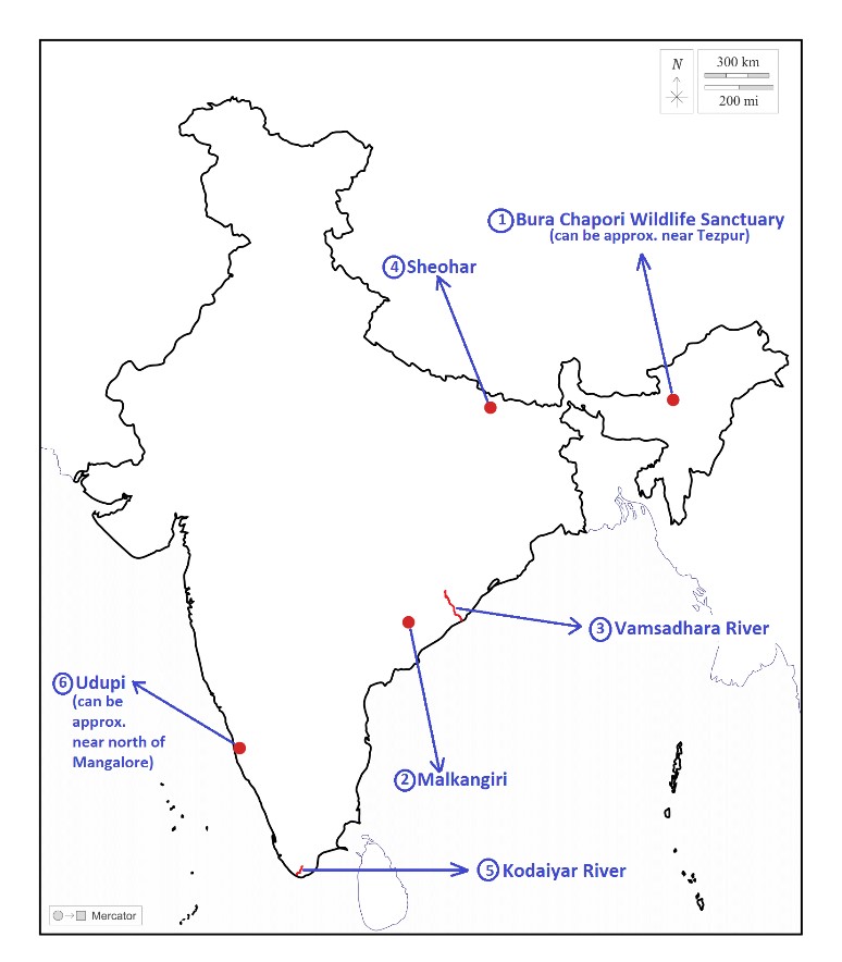
Bura Chapori Wildlife Sanctuary · Why in news: Recently, rhinoceros translocation study carried out in the sanctuary. · It is located in the Sonitpur district of Assam. · It forms an integral part of the Laokhowa-Burachapori eco-system and is a notified buffer of the Kaziranga Tiger reserve. · Brahmaputra River flows through the sanctuary. · It is considered to be an ideal habitat for the Bengal florican (IUCN, Critically Endangered). · Important fauna here includes Indian-one horned rhinoceros, Asiatic water buffalo and Bengal tiger. |
|
Malkangiri · Why in news: Odisha steps up drive against hemp cultivation in Malkangiri distrct. · It is the southernmost district of Odisha. Situated in the Eastern Ghats & it’s a part of Red Corridor. · Important rivers: Kolan, Potteru and Sileru. Darinage pattern: dendritic to sub-parallel. · Agriculture is the main occupation of the people here. Important crops: Paddy, Maize and Ragi. Shifting or Podu cultivation is practiced on high hill slopes. · Alfisols (Red Soil) and Ultisols (Lateritic soil) are found in the district. · Important tribes: Bondas, Gadabas, Kondhs and Koyas. |
|
Vamsadhara River · Why in news: Andhra Pradesh to set up institutional mechanism to address interstate issues with Odisha including decades-old Neradi barrage dispute over Vamsadhara River. · It is an east flowing river between Rushikulya and Godavari, in Odisha and Andhra Pradesh. · It originates in the Eastern Ghats of Rayagada district of Odisha and joins the Bay of Bengal at Kalingapatnam, Andhra Pradesh. · Mahendratanaya is a major tributary of the river which originates in Odisha. · Climate: Tropical savanna type (Koppen, Aw), Vegetation: Tropical moist deciduous. |
|
Sheohar · Why in news: Closure of India-Nepal border to contain COVID-19 deeply hurting the income of farmers in the district. · It is the smallest district of Bihar & located in the northwestern part of North Bihar plains. · Bagmati River is the important water body here & drainage pattern is sub-parallel in the district. · Climate: Hot sub-humid, Vegetation: Tropical moist deciduous. · Alluvial soils are found throughout the district. · Agriculture is the main occupation of the people here. Important crops: Paddy and Wheat. |
|
Kodaiyar River · Why in news: Due to heavy rainfall, Kodaiyar River surpassed the high flood mark by many times. · The Kodaiyar river basin forms the southernmost end of Indian peninsula & located in the Kanniyakumari district of Tamil Nadu. · It is one of the tributary of Tambaraparani or Kuzhithuraiyur River and its major tributaries are: Paralayar and Chittar · It has a dendritic drainage pattern. · Lateritic, red and brown soils are found in the command area of the river. · Important dams along the river are Pechiparai Dam, Perunchani Dam and Chittar Dam. |
|
Udupi · Why in news: Placexplore lab, a tourism incubator aimed at community-based tourism launched an initiative called Udupi in a box- a memento consists of the products made from GI tagged items from Udupi district. · It’s a coastal district in the state of Karnataka & nestled in Western Ghats. · Important rivers in the district: Kolluru, Suvarna, Sita and Shambhavi. · 80% of the people depend on rain fed agriculture. Important crops: Paddy, Chillies and Sweet poato. · Experiences typical maritime climate & receives majority of the rainfall from South West Monsoon. · Sandy, yellow loamy and red lateritic soils are found in the district. |
Share the article
Get Latest Updates on Offers, Event dates, and free Mentorship sessions.

Get in touch with our Expert Academic Counsellors 👋
FAQs
Geography Current Affairs focuses on the contemporary issues, events, and developments in the field of geography. It covers recent geographical phenomena, environmental changes, geopolitical shifts, and related news. This differs from regular geography studies which may focus more on foundational concepts, historical contexts, and theoretical frameworks.
Updates are provided regularly to ensure that subscribers stay informed about the latest developments in geography. Typically, updates are provided on a fortnightly basis, depending on the frequency of significant events and changes in the field.
Absolutely. Geography Current Affairs serves as a valuable resource not only for Geography optional but also for GS papers, especially GS Paper 1 (covering Indian Heritage and Culture, History, and Geography of the World and Society) and GS Paper 3 (covering Technology, Economic Development, Biodiversity, Environment, Security, and Disaster Management). It aids in building a holistic understanding of various topics and strengthens answer-writing skills by incorporating contemporary examples and perspectives.
Geography Current Affairs holds immense importance for UPSC preparation, particularly for aspirants opting for Geography optional. It helps candidates stay updated with the latest developments, geographical phenomena, environmental issues, and geopolitical shifts worldwide, aligning them with the dynamic nature of the subject as tested in the UPSC examinations.

