
10 Sep to 24 Sep, 2026
SAFEGUARDING THE STRATOSPHERIC SHIELD
Why in news : On the occasion of the International Day for the Preservation of the Ozone Layer (World Ozone Day, observed on 16th September), global attention was drawn to the historic journey of the Montreal Protocol.
About:
Ozone depletion is the thinning of the stratospheric ozone layer caused principally by human-produced chemicals containing chlorine and bromine. It illustrates how pollution released in one region can damage a shared planetary resource thousands of kilometres away. International action has placed recovery within reach, but persistent chemicals and emerging threats make continued protection essential.
1. Understanding ozone in the atmosphere
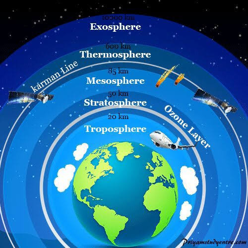
Ozone (O₃) consists of three oxygen atoms. Its environmental role depends on where it occurs.
|
Aspect |
Stratospheric ozone |
Tropospheric ozone |
|
Location |
Above the troposphere; the ozone-rich region lies mainly around 15–35 km |
Lowest atmospheric layer, including the air we breathe |
|
Share of atmospheric ozone |
Approximately 90% |
Approximately 10% |
|
Formation |
Solar ultraviolet radiation splits oxygen molecules; oxygen atoms then combine with O₂ |
Sunlight drives reactions involving nitrogen oxides, volatile organic compounds and other gases |
|
Significance |
Shields life from harmful ultraviolet radiation |
Excess concentrations damage lungs, vegetation and crops; ozone also acts as a greenhouse gas |
Thus, protecting stratospheric ozone and reducing ground-level ozone pollution are complementary environmental goals. Increased ozone in polluted cities cannot compensate for depletion above them.
Formation and natural balance
Stratospheric ozone forms through a sunlight-driven cycle:
O2+UV radiation→O+OO_2+\text{UV radiation}\rightarrow O+O O+O2+M→O3+MO+O_2+M\rightarrow O_3+M
Here, M is another molecule that carries away excess energy. Ozone also undergoes natural destruction; depletion occurs when additional destructive reactions disturb this balance.
Measurement: Total-column ozone is measured in Dobson Units (DU). A typical atmospheric column of 300 DU would form a layer only 3 mm thick if compressed to standard temperature and pressure. The ozone layer is therefore a diffuse concentration of gas, not a solid atmospheric sheet.
When was ozone depletion identified?
Two milestones distinguish the scientific warning from the discovery of severe depletion:
- 1974—CFC threat explained: Mario Molina and F. Sherwood Rowland demonstrated how chlorofluorocarbons could release ozone-destroying chlorine in the stratosphere. Their work, together with Paul Crutzen’s atmospheric chemistry research, received the 1995 Nobel Prize in Chemistry.
- 1985—Antarctic ozone hole reported: British Antarctic Survey scientists Joe Farman, Brian Gardiner and Jonathan Shanklin published evidence of substantial springtime ozone losses over Antarctica. Their observations showed departures from earlier conditions beginning in the late 1970s.
The “ozone hole” is severe thinning, not complete disappearance. Its area is conventionally identified using total-column ozone values below approximately 220 DU.
Why is depletion particularly severe over Antarctica?
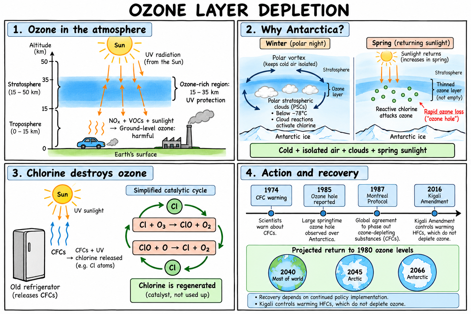
Antarctica combines the conditions required for exceptionally rapid ozone destruction.
A. Extreme stratospheric cold
Winter temperatures fall below approximately −78°C, enabling polar stratospheric clouds (PSCs) to form. Their surfaces support reactions that convert relatively inactive chlorine compounds into readily activated forms.
B. A strong, persistent polar vortex
A belt of powerful circumpolar winds isolates Antarctic stratospheric air. This maintains low temperatures and restricts replenishment by ozone-rich air from lower latitudes.
C. Return of spring sunlight
During polar winter, chemical activation prepares the system. When sunlight returns in August–September, it releases reactive chlorine from accumulated compounds, initiating rapid ozone destruction.
D. Conditions persist long enough for extensive loss
The Antarctic vortex commonly remains cold and isolated into spring, producing the most pronounced depletion around September–October. Summer warming and vortex breakdown end the intense seasonal episode.
Geographical implication: Antarctica is severely affected because of its atmospheric conditions, rather than because it emits the most CFCs. Long-lived pollutants circulate globally before causing their greatest damage there.
4. Does ozone depletion occur elsewhere?
Yes. Ozone depletion is global, although its severity and seasonality vary.
|
Region |
Pattern and explanation |
|
Antarctica |
Recurring, extensive springtime ozone hole because of sustained cold and atmospheric isolation |
|
Arctic |
Significant late-winter and spring depletion; exceptional losses occurred in 2011 and 2020 |
|
Northern and southern mid-latitudes |
Broader thinning has occurred, without the same recurring Antarctic-scale hole |
|
Tropics |
Naturally lower total-column ozone does not by itself establish an “ozone hole”; atmospheric circulation strongly influences ozone distribution |
The Arctic usually experiences less severe depletion because its stratosphere is warmer and its vortex is more frequently disturbed. Northern Hemisphere topography and land–sea contrasts generate atmospheric waves that disrupt the vortex.
5. Principal causes of ozone depletion
A. Release of ozone-depleting substances
|
Substance |
Major historical applications |
Ozone-depleting component |
|
CFCs |
Refrigerators, air conditioners, aerosol propellants and foam manufacture |
Chlorine |
|
Halons |
Fire suppression systems |
Bromine |
|
HCFCs |
Refrigeration and foam manufacture; transitional CFC replacements |
Chlorine |
|
Carbon tetrachloride and methyl chloroform |
Chemical manufacture and industrial cleaning |
Chlorine |
|
Methyl bromide |
Agricultural and quarantine fumigation |
Bromine |
Many of these compounds remain intact long enough to reach the stratosphere, where intense ultraviolet radiation breaks them down. HCFCs have lower ozone-depleting potential than many CFCs, but they still damage ozone.
B. Catalytic destruction
Released chlorine repeatedly participates in reactions that destroy ozone while regenerating the chlorine.
A simplified cycle is:
Cl+O3→ClO+O2Cl+O_3\rightarrow ClO+O_2 ClO+O→Cl+O2ClO+O\rightarrow Cl+O_2
Because chlorine is regenerated, one atom can destroy over 100,000 ozone molecules before removal from the stratosphere. Antarctic loss involves additional pathways, particularly reactions involving chlorine monoxide.
C. Nitrous oxide
N₂O, emitted through agricultural nitrogen use, manure management and industrial activities, produces reactive nitrogen in the stratosphere that can destroy ozone. UNEP’s 2024 Global Nitrous Oxide Assessment identifies it as a major continuing threat to both ozone protection and climate stability.
6. Why does ozone depletion matter?
A. Human health
Stratospheric ozone absorbs much of the Sun’s harmful UV-B radiation. Depletion increases exposure, raising risks of skin cancer, cataracts and immune-system damage.
B. Agriculture and terrestrial ecosystems
Additional UV-B can impair plant growth and photosynthesis. Responses vary between species and crop varieties, so impacts cannot be represented by one universal yield-loss figure.
C. Marine food webs
UV-B can harm phytoplankton and the early developmental stages of fish and other marine organisms. Damage at these levels can affect wider food webs and ecosystem productivity.
D. Materials and infrastructure
Greater UV exposure accelerates deterioration of plastics and other exposed materials, increasing replacement and maintenance costs.
E. Climate interactions
Ozone absorbs radiation and influences stratospheric temperature. Its depletion alters temperature gradients and circulation, particularly in the Southern Hemisphere. Moreover, many ozone-depleting chemicals are powerful greenhouse gases, so their phase-out delivers a substantial climate benefit. Ozone depletion and global warming are connected but distinct processes.
7. Global initiatives: from scientific warning to implementation
A. Major agreements
|
Initiative |
Central contribution |
|
Vienna Convention, 1985 |
Established a framework for research, monitoring and international cooperation |
|
Montreal Protocol, 1987; effective 1989 |
Introduced binding controls on production and consumption of ozone-depleting substances |
|
Successive amendments and adjustments |
Expanded controlled substances and strengthened phase-out schedules as evidence and alternatives improved |
|
Montreal Amendment, 1997 |
Required licensing systems for trade in controlled ozone-depleting substances |
|
Kigali Amendment, 2016; effective 2019 |
Established a phase-down of HFCs to limit climate warming |
The Vienna Convention and Montreal Protocol have achieved universal ratification, with 198 parties. This does not mean every later amendment has identical participation.
Essential distinction: HFCs generally do not deplete ozone. They replaced many ozone-depleting refrigerants but created a climate problem because many have high global-warming potential. Kigali addresses that problem
Programmes that made the agreements workable
- Multilateral Fund, operational since 1991: Finances eligible transition costs in developing countries, connecting environmental obligations with practical financial support.
- UNEP OzonAction: Supports national ozone units, customs enforcement, technician training and compliance.
- UNDP, UNIDO and World Bank projects: Assist industrial conversion and adoption of alternative technologies.
- Scientific and technical assessment panels: Regularly evaluate atmospheric science, environmental effects and available substitutes.
- Monitoring networks: Ground observations and satellites measure ozone and track chemicals, allowing independent verification of reported progress.
Why the approach worked: Binding schedules were combined with finance, differentiated timelines, technological alternatives and repeated scientific review.
8. India’s national initiatives
India joined the Montreal Protocol in June 1992 and implements its commitments through the Ozone Cell under MoEFCC.
|
Programme or measure |
Contribution and evidence |
|
ODS (Regulation and Control) Rules, 2000, with amendments |
Regulate controlled substances through restrictions, registration and licensing |
|
HCFC Phase-out Management Plans—HPMPs |
Support industrial conversion and servicing-sector improvements; India reported achieving its 67.5% reduction target in HCFC production and consumption in 2025 |
|
HCFC-141b phase-out in foam manufacturing |
Completed from 1 January 2020, removing an important ozone-depleting foam-blowing agent |
|
India Cooling Action Plan, 2019 |
Targets reductions by 2037–38 of 20–25% in cooling demand, 25–30% in refrigerant demand, and 25–40% in cooling energy requirements, against projected reference demand |
|
Kigali implementation |
India’s HFC reduction schedule begins in 2032, reaching an 85% reduction by 2047 against its prescribed baseline |
|
Technician training |
In 2025, MoEFCC announced refrigeration and air-conditioning training-equipment support for 120 ITIs |
These initiatives connect chemical phase-out with energy efficiency, industrial capability and skilled servicing. ICAP figures are targets, not reductions already achieved.
|
Case study : India’s foam-sector transition India eliminated HCFC-141b use in foam manufacturing from January 2020, combining regulatory restrictions with industrial conversion. Lesson: Sector-specific technical and financial assistance makes environmental commitments implementable at the factory level. |
Is the ozone layer recovering?
Yes, but recovery is gradual and geographically uneven.
The UN-backed assessment reported the phase-out of nearly 99% of banned ozone-depleting substances. Under continued implementation of existing policies, ozone is projected to return to 1980 levels approximately as follows:
|
Region |
Expected return |
|
Most of the world |
2040 |
|
Arctic |
2045 |
|
Antarctic |
2066 |
These are conditional projections, not guaranteed completion dates. Long-lived chemicals remain in the atmosphere, while temperature and circulation produce substantial year-to-year variability. One unusually large ozone hole does not by itself overturn the long-term recovery trend.
Further threats and unresolved challenges
- Existing chemical “banks”: Old refrigeration equipment and insulating foams can release ODS during use, demolition or disposal.
- Illegal production and industrial leakage: Undeclared manufacture and emissions from permitted chemical feedstock uses can undermine progress.
- Rising N₂O emissions: Agricultural and industrial nitrogen emissions create a continuing ozone–climate challenge.
- Wildfires and volcanic eruptions: Material injected into the stratosphere can modify chemical reactions and cause temporary ozone losses.
- Expanding space activity: Rocket emissions and particles from satellite re-entry pose emerging risks; their future magnitude remains uncertain.
- Solar geoengineering: Proposed stratospheric aerosol injection could alter ozone chemistry and recovery.
- Changing climate and circulation: Greenhouse gases affect stratospheric temperatures and ozone transport differently across regions and altitudes; the response is not uniformly beneficial or harmful.
Way forward
- Complete scheduled phase-outs: Maintain enforcement, customs cooperation and support for small enterprises adopting alternatives.
- Manage refrigerants throughout their life cycle: Require recovery, recycling, reclamation or safe destruction during servicing and disposal.
- Combine ozone safety with climate performance: Evaluate refrigerants for ozone-depleting potential, global-warming potential, energy efficiency and safe handling.
- Reduce unnecessary cooling demand: Implement passive building design, insulation and efficient cooling alongside refrigerant substitution.
- Address nitrogen emissions: Improve fertiliser efficiency, manure management and industrial N₂O abatement.
- Protect scientific monitoring: Sustain satellites, ground stations and atmospheric chemical networks to detect unexpected emissions early.
- Assess emerging activities before large-scale expansion: Strengthen research on rocket emissions, satellite re-entry and proposed geoengineering.
- Maintain equitable finance and technology access: Affordable alternatives and trained workers are essential for durable compliance.
Ozone recovery demonstrates that environmental damage can be reversed when scientific evidence is translated into enforceable commitments and practical assistance. The remaining task is to secure that recovery while preventing replacement technologies and emerging activities from creating new atmospheric risks.
https://wmo.int/themes/ozone-layer
Where to use :
Paper III ( General Studies ) : Climate change and Conservation
CRITICAL MINERALS AND DEEP SEA EXPLORATION
Why in news: India's growing focus on deep-sea exploration and seabed minerals has opened new opportunities for strategic mineral security, renewable energy, electric mobility and advanced manufacturing.
About ;
The transition towards electric vehicles, renewable energy and advanced manufacturing is changing the geography of strategic resources. Alongside oil and gas, countries increasingly compete for lithium, copper, cobalt, nickel, graphite and rare-earth elements.
India’s interest in seabed minerals reflects this shift. However, mineral discovery becomes economic security only when extraction, processing, manufacturing and environmental safeguards work together. Deep-sea exploration offers a possible additional source of minerals; its commercial and ecological viability must still be established.
1. What makes a mineral “critical”?
A mineral becomes critical when it combines:
- High economic or strategic importance: Essential for industries, infrastructure or defence.
- Significant supply risk: Production or processing is concentrated, imports are vulnerable, or substitutes are difficult to obtain.
Critical does not necessarily mean geologically rare. A widely distributed mineral can become critical because only a few countries possess the technology to process it economically.
Criticality also changes with technology and national circumstances. India identified 30 critical minerals in 2023, including lithium, cobalt, graphite and rare-earth elements.
Three distinctions to remember
|
Terms |
Essential distinction |
|
Critical minerals and rare earths |
Rare earths are a specific group of elements; critical minerals are a broader policy category |
|
Resources and reserves |
Resources indicate geological availability; reserves are the economically recoverable portion under specified conditions |
|
Exploration and mining |
Exploration investigates deposits and environmental conditions; mining extracts material for use or sale |
Thus, an exploration announcement does not establish a commercially viable mine.
2. Why are these minerals central to modern economies?
|
Sector |
Important minerals/materials |
Function |
|
Electric vehicles and battery storage |
Lithium, graphite; nickel, cobalt and manganese in particular chemistries |
Store electricity and influence battery performance |
|
Electricity grids |
Copper and aluminium |
Conduct electricity through cables, transformers and connections |
|
Wind turbines and electric motors |
Neodymium and praseodymium; sometimes dysprosium and terbium |
Produce strong permanent magnets in relevant designs |
|
Solar and electronics |
Silicon, silver; gallium, germanium and other specialised materials |
Semiconductor, photovoltaic and electronic applications |
|
Hydrogen technologies |
Platinum and iridium in certain systems |
Catalyse reactions in fuel cells and electrolysers |
|
Defence and aerospace |
Titanium, tungsten, rare earths and cobalt |
High-strength components, heat-resistant alloys and specialised equipment |
Requirements vary by technology: not every EV battery uses cobalt, and not every wind turbine uses rare-earth magnets.
A changing form of energy dependence
Fossil-fuel systems require continuous fuel supplies. Clean-energy systems require substantial mineral inputs to manufacture equipment, after which many materials remain available for recycling.
Consequently, energy security increasingly includes access to industrial materials and processing technology, alongside access to fuels.
3. The global geography: deposits and industrial power differ
A. Mineral production is unevenly distributed
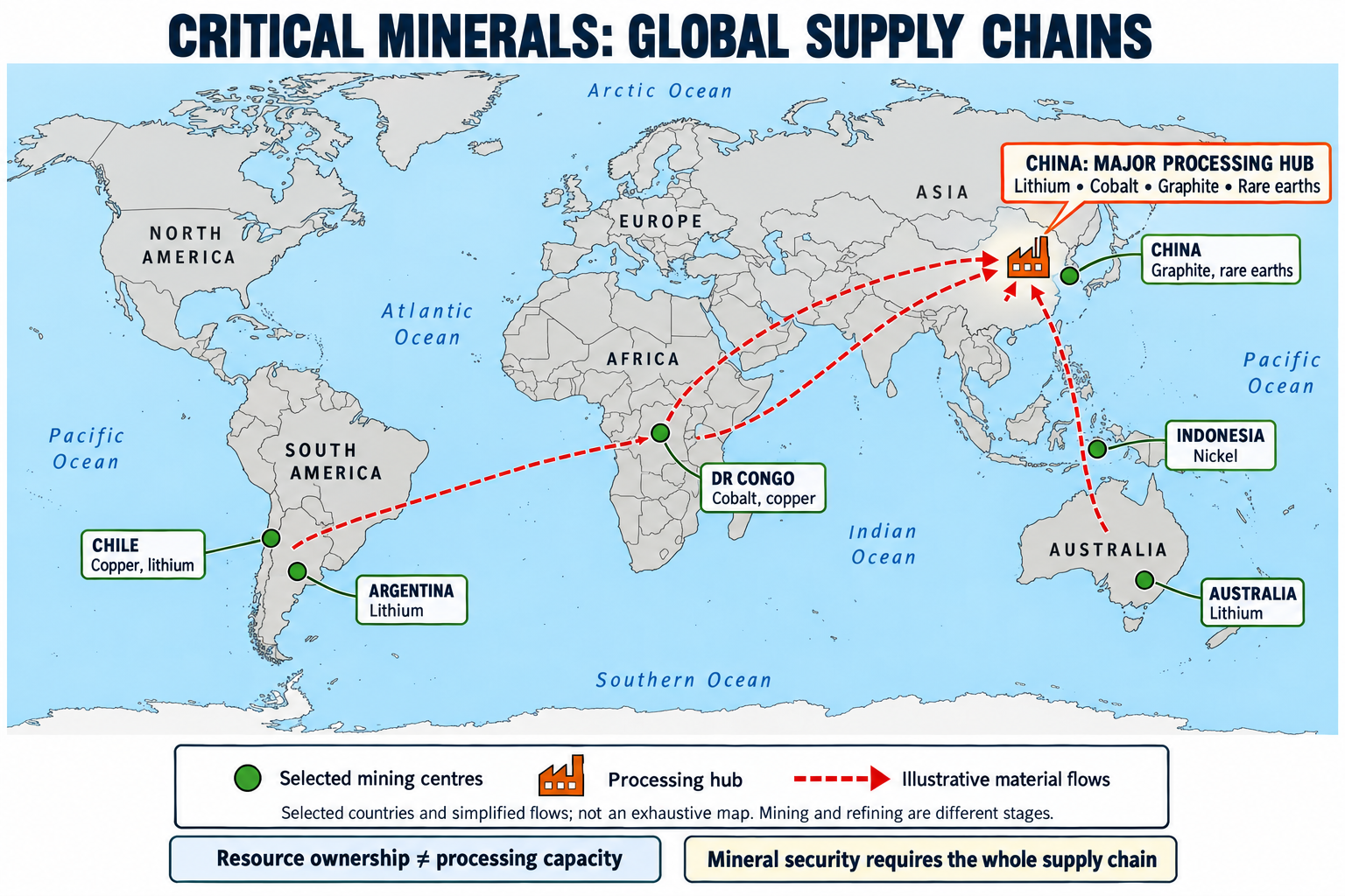
Important geographical concentrations include:
- Democratic Republic of the Congo: Cobalt and copper.
- Indonesia: Nickel.
- Australia: Lithium and other mineral resources.
- Chile and Argentina: Lithium; Chile is also a major copper producer.
- China: Graphite, rare earths and extensive mineral-processing capacity.
These patterns reflect geology, investment, infrastructure and industrial policy—not geology alone.
B. Processing creates a second layer of dependence
A country can own mineral deposits yet export low-value ore and import expensive batteries or magnets.
The IEA reported that the average share of the three largest refining countries across six key energy minerals reached 86% in 2024, compared with approximately 82% in 2020. This is an average across mineral markets, not one combined market share.
Analytical implication: Strategic power often lies in the ability to convert ore into high-purity materials, components and finished products.
C. Supply restrictions now affect manufacturing
The IEA’s 2026 assessment records how China’s April 2025 rare-earth export controls disrupted downstream industries, including some automobile operations. It also identifies the DRC’s cobalt export quota as a factor reshaping supply expectations.
The same assessment projects a potential copper supply deficit of approximately 25% by 2035, based on the project pipeline and its demand outlook. This is a scenario-based warning, not an inevitable outcome.
4. Why explore the deep sea?
Deep-sea exploration investigates seabed geology, mineral deposits and ecosystems using research vessels, sonar, sampling equipment, remotely operated vehicles and autonomous underwater vehicles.
It attracts attention because it could:
- Diversify supply: Add sources outside established terrestrial mining centres.
- Provide several metals together: Some deposits contain commercially interesting combinations of manganese, nickel, cobalt and copper.
- Build technological capability: Advance underwater robotics, sensors, navigation and ocean engineering.
- Improve scientific knowledge: Establish environmental baselines and identify habitats requiring protection.
Exploration therefore has scientific value even where mining never proceeds. NOAA’s programmes explicitly combine mapping, geological sampling and biological observations.
5. Which seabed deposits contain useful minerals?
|
Deposit |
Formation and setting |
Important metals |
Examples |
|
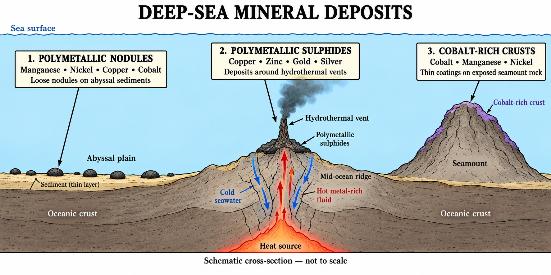
Polymetallic nodules |
Slowly growing concretions lying on abyssal sediments, commonly around 4,000–6,500 m depth |
Manganese, nickel, copper, cobalt |
Clarion–Clipperton Zone; Central Indian Ocean Basin |
|
Polymetallic sulphides |
Metal-rich hydrothermal fluids cool and precipitate minerals near seafloor vents |
Copper, zinc, gold, silver and other metals |
Mid-ocean ridges, including Indian Ocean ridges |
|
Cobalt-rich ferromanganese crusts |
Minerals accumulate on exposed rock surfaces, especially seamounts |
Cobalt, manganese, nickel; some rare earths and platinum |
Particularly explored in the Pacific |
These deposits require different collection technologies and create different environmental risks. Nodules lie on sediment; crusts adhere to rock; sulphides form three-dimensional deposits.
Important limitation: Nodules mainly offer manganese, nickel, cobalt and copper. They do not provide a complete solution for lithium, graphite or every rare-earth requirement.
6. How would seabed mining work?
For nodules, the proposed system generally involves:
- A collector vehicle moving across the seabed.
- Collection and transfer of nodules through a lifting system.
- Delivery to a surface vessel.
- Transport to onshore processing facilities.
- Separation and refining into usable metals.
A 2022 collector trial in the Clarion–Clipperton Zone recovered more than 3,000 tonnes of nodules, demonstrating an integrated system at trial scale. It did not establish long-term profitability or environmental acceptability.
The critical connection: Seabed mining still requires land-based processing. A new source of ore may leave dependence on existing refiners largely unchanged.
7. What is happening internationally?
A. Competition increasingly covers entire supply chains
Governments are supporting mineral exploration, refining, manufacturing, recycling and overseas partnerships. The strategic objective is to reduce exposure to a small number of suppliers.
B. The European Union has set diversification benchmarks
The Critical Raw Materials Act establishes 2030 benchmarks for strategic raw materials:
- 10% of annual consumption supplied through EU extraction capacity.
- 40% through EU processing capacity.
- 25% through EU recycling capacity.
- No more than 65% of annual consumption of each strategic raw material at a relevant processing stage sourced from one non-EU country.
These are policy benchmarks, not achievements already secured.
C. The United States is advancing a separate seabed permitting route
Following an April 2025 executive order, NOAA revised its application regulations in January 2026. Its September 2026 information lists a commercial-recovery application under review, but no issued commercial-recovery permits.
The US is not a party to UNCLOS and uses its domestic Deep Seabed Hard Mineral Resources Act. The ISA disputes attempts to authorise exploitation of international seabed resources outside the UNCLOS framework.
D. International mining rules remain unfinished
The ISA’s September 2026 update confirms continuing negotiations on exploitation regulations, environmental standards and related requirements, with further work scheduled for 2027.
Therefore, exploration contracts should not be described as commercial mining permissions.
8. Who governs seabed minerals?
Two legal spaces must be distinguished:
|
Space |
Governance principle |
|
Seabed within national jurisdiction |
Coastal states exercise relevant sovereign resource rights, including continental-shelf rights |
|
Seabed beyond national jurisdiction—the “Area” |
Under UNCLOS, its resources are the common heritage of humankind, administered through the ISA framework |
The continental shelf can extend beyond 200 nautical miles where UNCLOS requirements are met. Consequently, “beyond the EEZ” does not automatically mean international seabed.
The common-heritage principle raises questions about benefit sharing, environmental protection and access for developing countries, rather than permitting unrestricted first-come ownership.
9. India’s strategy: several complementary approaches
A. National Critical Mineral Mission
Approved in January 2025, the mission covers 2024–25 to 2030–31:
- ₹16,300 crore in proposed government expenditure.
- ₹18,000 crore in expected investment from public-sector enterprises and other stakeholders.
- Support across exploration, mining, processing and recovery from end-of-life products.
The distinction matters: the combined ₹34,300 crore includes expected investment, not only budgetary expenditure.
B. Deep Ocean Mission
Approved in 2021, with an initial five-year estimated cost of ₹4,077 crore, it supports ocean exploration, deep-sea technologies and wider ocean science.
Under Samudrayaan, the MATSYA-6000 submersible is designed to carry three people to a depth of 6,000 metres. It is an exploration platform, not a commercial mining vehicle.
Progress must be described carefully: A March 2026 parliamentary reply confirmed harbour trials in January–February 2025 and reported remaining requirements for a shallow-water dive. It also clarified that mining-system mobility and power trials at 5,270 m occurred in 2021, not 2025.
C. Indian Ocean exploration contracts
|
Area |
Deposit |
Contract area |
|
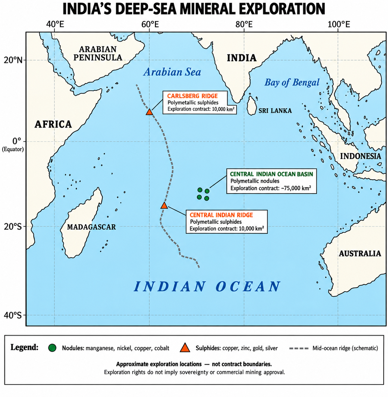
Central Indian Ocean Basin |
Polymetallic nodules |
Approximately 75,000 km² |
|
Central Indian Ridge region |
Polymetallic sulphides |
10,000 km² |
|
Carlsberg Ridge |
Polymetallic sulphides |
10,000 km² |
The Carlsberg Ridge contract was signed in September 2025. These are exploration areas, not sovereign territorial acquisitions or proven commercial reserves.
D. Overseas mineral partnerships
In January 2024, KABIL signed an agreement covering exploration and development of five lithium blocks in Catamarca, Argentina.
This demonstrates why India needs multiple routes: overseas lithium partnerships, domestic exploration, recycling and ocean research address different supply requirements.
10. Major challenges
A. Ecological damage may persist for decades
Mining removes or disturbs habitats, while nodules themselves provide surfaces for attached organisms. Their extremely slow formation makes replacement impractical on human timescales.
Case study: Research published in 2025 examined a Pacific mining-test site 44 years after disturbance. Physical impacts and changes in biological communities persisted, although some organisms showed recovery.
Lesson: Partial recolonisation does not demonstrate full ecosystem restoration.
B. Impacts can extend beyond the collector’s path
Sediment plumes, redeposition, noise and discharge can affect organisms outside the directly mined area. Research also raises concerns about interactions between discharge particles and midwater food webs.
The scale depends on equipment, currents, discharge depth and ecosystem characteristics; it cannot be assumed to be either negligible or uniform.
C. Engineering success does not guarantee commercial success
Operations must withstand high pressure, corrosion, difficult maintenance and long distances from shore. Costs also include vessels, lifting systems, processing, monitoring and financial liability.
Profitability depends on metal prices, recovery rates and regulation—not simply the estimated quantity of seabed minerals.
D. Technological change can alter mineral demand
Lithium iron phosphate—LFP—batteries do not require nickel or cobalt in their cathodes. Their growing use changes the demand assumptions supporting some nodule-mining proposals.
The IEA reported that LFP supplied almost half the global electric-car market in its 2025 assessment, up from less than 10% in 2020.
Lesson: Projects must remain viable under alternative battery technologies, rather than assume one chemistry will dominate indefinitely.
E. “Green” technologies can shift environmental burdens
Land mining can damage forests, water resources and communities; seabed mining can damage poorly understood marine ecosystems.
A credible comparison must assess whole-life impacts, affected habitats and social costs. Avoiding terrestrial damage does not automatically establish that ocean extraction is sustainable.
F. Unequal benefits can reproduce resource dependence
Resource-rich countries may receive limited value if foreign firms control refining, technology and manufacturing. Small island states also face difficult choices between potential revenue and environmental liabilities.
This connects the issue to the geographical concepts of core–periphery relations, unequal exchange and the resource curse.
11. Way forward: mineral security with environmental responsibility
- Build complete value chains: Invest in refining, separation, battery materials and magnets alongside exploration.
- Diversify selectively: Combine domestic resources, overseas partnerships, long-term purchase agreements and limited strategic stocks.
- Expand urban mining: Recover metals from batteries, electronics, industrial waste and suitable mine tailings.
- Reduce material demand: Encourage efficient product design, smaller batteries where appropriate, public transport and longer equipment life.
- Support substitution: Develop alternative battery chemistries and motor designs while assessing their own supply dependencies.
- Keep exploration distinct from extraction: Continue scientific research without treating every discovery as justification for mining.
- Apply precaution offshore: Require independent baseline studies, cumulative-impact assessment, protected reference areas and enforceable environmental thresholds before commercial approval.
- Make operators accountable: Establish transparent monitoring, financial guarantees and liability arrangements for long-term damage.
- Protect equitable benefits: Ensure producing countries and affected communities gain skills, revenue and industrial opportunities.
- Stress-test investments: Evaluate projects against changing prices, technologies, environmental obligations and geopolitical conditions.
Recycling will reduce future primary demand, but cannot immediately supply a rapidly expanding stock of batteries, grids and other equipment. A balanced strategy therefore combines responsible primary supply, circular use and demand efficiency.For India, the strongest approach is to develop ocean capabilities while building diversified, technologically advanced and environmentally accountable mineral supply chains. The decisive measure of success is reliable access to usable materials without transferring unacceptable costs to communities or future generations.
Where to use:
Paper 1 ( Geography optional ): Economic Geography
Paper 1 ( General studies ) : Minerals
DEDICATED FREIGHT CORRIDORS
Why in news: Western Dedicated Freight Corridor (WDFC) has become fully operational, marking a major milestone in India’s freight infrastructure. Together with the Eastern Dedicated Freight Corridor (EDFC), India now has a 2,843-km dedicated freight rail backbone, strengthening the logistics architecture envisioned under PM GatiShakti.
About:
Dedicated Freight Corridors (DFCs) are railway routes reserved for goods trains. By separating freight from passenger traffic, they reduce congestion and reorganise connections between production centres, markets and ports. India’s principal corridors are the Eastern DFC: Ludhiana–Sonnagar, 1,337 km, and Western DFC: Dadri–JNPT, 1,506 km. Together, they represent 2,843 km of strategic transport infrastructure.
Their geographical significance extends beyond faster transportation:
- Time–space convergence: Faster, predictable movement reduces the effective economic distance between regions. The World Bank reported typical operational DFC speeds of 40–60 km/h, approximately double conventional freight speeds, and traffic of 90 billion net tonne-kilometres in 2024–25. Lower transit uncertainty reduces inventory costs.
- Industrial location: Applying Weber’s least-cost theory, cheaper transport changes the relative attractiveness of industrial locations. Inland manufacturers around NCR and Rajasthan gain improved access to western ports, potentially reducing their disadvantage against coastal producers.
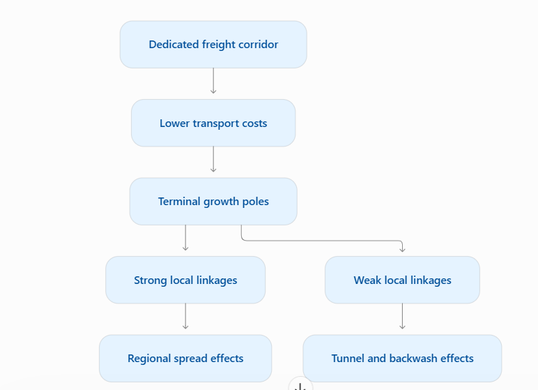
- Growth poles and development axes: In Perroux’s framework, industries concentrated around freight terminals can stimulate suppliers, warehousing and services. Links between such nodes can create development axes; the Western DFC supports the broader Delhi–Mumbai industrial corridor strategy.
- Spatial complementarity: Following Ullman, trade requires complementary demand and supply alongside transferability. The Eastern DFC improves transferability between eastern mineral supplies and northern industrial markets.
- Environmental and network benefits: Shifting suitable cargo from roads to electrified rail can reduce emissions, fuel consumption and road congestion. Separating freight also releases capacity for passenger services.
However, limitations reveal the difference between corridor construction and regional development:
- Terminal bottlenecks: Fast trunk movement delivers limited benefits when feeder lines, warehouses and port interfaces remain inefficient. The World Bank identifies a nationwide shortage of 150–200 modern freight terminals, illustrating this wider constraint.
- Uneven development: Myrdal’s backwash effects suggest stronger nodes may attract capital and labour from weaker regions. A corridor can pass through a district without generating substantial local employment—the tunnel effect.
- Social and ecological costs: Land acquisition, fragmented agricultural holdings, settlement severance and disrupted drainage can transfer costs onto local communities.
- Commercial constraints: Small consignments, transshipment costs and unreliable door-to-door connections can preserve trucking’s advantage. Heavy dependence on bulk commodities also limits diversification.
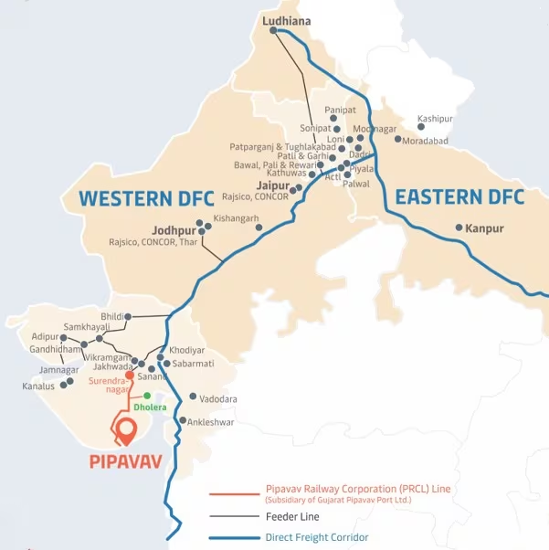
The way forward is integrated regional planning. PM Gati Shakti should coordinate DFCs with feeder railways, ports, highways and industrial estates. Common-user terminals, cargo aggregation and transparent tariffs can improve MSME access. Local procurement, skills and secondary-town investment should spread benefits beyond major hubs. Fair compensation, crossings, drainage protection and climate-resilient engineering must accompany expansion.Thus, DFCs are potential instruments of spatial integration. Their success should be assessed through reliable logistics, wider market access and inclusive regional development, alongside freight volumes.
Source :
Where to use ?
Paper II ( Geography Optional ): Trade and Transport
Orographic Dissymmetry
Orographic Dissymmetry: It refers to the asymmetry between the two sides of a mountain range, caused by differences in slope, climate, vegetation and erosion. In the Western Ghats, the windward western slope is steep, wet and heavily dissected, while the leeward eastern slope is gentle, dry and rain-shadowed. This contrast affects drainage, soils and land use on either side.
Rossby Waves
Rossby Waves: Rossby waves are large, meandering, west-to-east undulations in the upper-atmosphere westerly winds (jet streams) of the mid-latitudes. They arise from the Earth's rotation and the variation of the Coriolis force with latitude. They transport heat and momentum between the tropics and poles, steer weather systems, and influence phenomena like western disturbances, cold waves and blocking highs.
Morphogenetic Region
Morphogenetic Region: A morphogenetic region is an area where a distinct climate produces a characteristic set of landforms through dominant geomorphic processes. The concept was developed by Peltier and Büdel, and it recognises that climate controls weathering and erosion. Examples include glacial, periglacial, arid, semi-arid, humid tropical and savanna regions, each with its own typical landscape features.
Allelopathy
Allelopathy: Allelopathy is a biological phenomenon in which a plant releases biochemicals (allelochemicals) through roots, leaves, or decaying matter that inhibit or sometimes promote the germination, growth or survival of neighbouring plants. It helps species reduce competition for light, water and nutrients. Examples include the black walnut (juglone), eucalyptus and Parthenium, which suppress nearby vegetation and affect crop yields and community structure.
Trophic Cascade_24 sept 2026
Trophic Cascade: A trophic cascade is an ecological process in which changes at one trophic level, usually the top predators, ripple down through the food web and affect lower levels. For example, reintroducing wolves in Yellowstone reduced elk numbers and browsing pressure, allowing willows and aspens to recover, which in turn benefited beavers, birds and stream stability, showing the importance of predators in ecosystem balance.
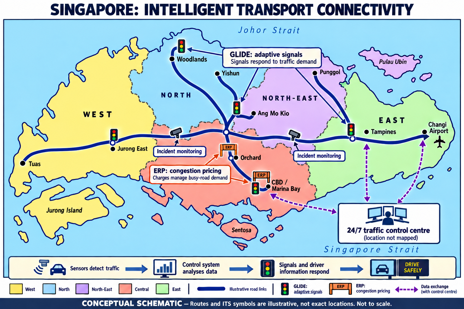
Singapore’s Intelligent Transport System
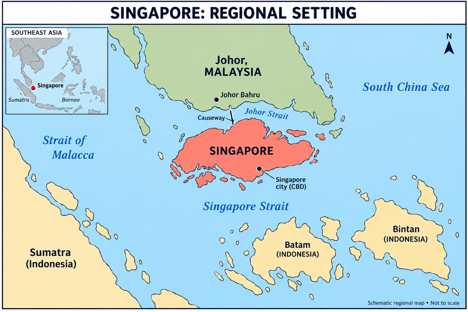
Singapore uses an Intelligent Transport System (ITS) to manage traffic through sensors, computers and electronic pricing. For this densely populated island, efficient use of limited road space is crucial. Its approach combines managing traffic flow with managing travel demand.
1. Adaptive traffic signals—GLIDE: Introduced in 1988, the Green Link Determining System covered approximately 2,700 intersections by 2024, according to Singapore’s Land Transport Authority. Sensors beneath roads detect vehicles, allowing computers to adjust green-light duration according to traffic demand. Neighbouring signals are coordinated to reduce repeated stops. For example, heavier morning traffic towards employment centres receives greater priority. Unlike fixed timers, this system responds to changing traffic conditions.
2. Electronic Road Pricing—ERP: Introduced in 1998, ERP charges vehicles at selected locations and times. Charges are periodically reviewed using observed congestion. Drivers can respond by changing routes, travelling outside busy periods or using public transport. This applies congestion pricing: scarce road space carries a higher cost when demand increases.
A concrete example is Orchard’s shopping district. From 7 September 2026, weekday ERP charges resumed at S$1 per passenger-car unit between 11:00 and 19:00, after persistent congestion. The stated optimal speed range for arterial roads is 20–30 km/h; this is a management target, not a universally achieved outcome.
3. Integrated monitoring: A control centre operates 24/7, monitoring expressways and tunnels and coordinating incident management. This supports quicker responses to disruptions and more reliable journeys.
Geographically, Singapore illustrates network optimisation and transport demand management. Technology improves flows through existing infrastructure, while pricing influences when and where people travel.
However, charges can burden lower-income motorists, and diverted traffic may congest alternative roads. Sensors also require maintenance and dependable data. Therefore, intelligent transport works best alongside affordable public transport, pedestrian facilities and regular evaluation. Singapore’s lesson is that smarter mobility requires coordinated technology, pricing and accessible alternatives.
Places in News - 24 September 2026
1. Kishau Multipurpose Project
Why in news : In a major push to resolve long-pending inter-state water disputes, six northern states Uttarakhand, Himachal Pradesh, Uttar Pradesh, Haryana, Rajasthan, and Delhi signed a historic Memorandum of Understanding (MoU) to pave the way for the Kishau Multipurpose Project.
About :
- Location: Proposed on the Tons River (a major tributary of the Yamuna), near Kishau village on the Uttarakhand–Himachal Pradesh border, in the Dehradun (Uttarakhand) and Sirmaur (Himachal Pradesh) districts.
- It regulates Yamuna basin flows, adding water storage for the lean season and supporting the upper Yamuna system, which is important for the Indo-Gangetic plains.
2. Chitradurga
Why in news : A successful trial run delivered water from the Bhadra reservoir through the Chitradurga Branch Canal to Gonur Lake, ending a 50-year wait for the residents of central Karnataka. This milestone marks the operational initiation of the Upper Bhadra Project, addressing severe water scarcity in the region's semi-arid zones.
About :
- A district and town in central Karnataka, on the Deccan Plateau, about 200 km northwest of Bengaluru. It lies in the Vedavathi river basin, and the Vedavathi is a tributary of the Tungabhadra.
- The area is dotted with rocky hills and granite outcrops of the Dharwar craton, with Archaean rocks (Chitradurga schist belt, part of the Dharwar system). The famous Chitradurga Fort is built on these granite hills.
- Known for mineral resources like manganese, iron ore, and limestone. It is also the site of major scientific and wind energy developments, including the Challakere science city (ISRO, DRDO, IISc, BARC facilities) and large wind farms.
3. Agasthyamalai Biosphere Reserve
Why in news: The Jawaharlal Nehru Tropical Botanic Garden and Research Institute (JNTBGRI), Thiruvananthapuram, has compiled a new checklist of flowering plants in the Agasthyamalai Biosphere Reserve (ABR), highlighting the global biodiversity significance of the Western Ghats.
About :
- Situated in the southern Western Ghats, spanning Kerala (Thiruvananthapuram, Kollam, Pathanamthitta districts) and Tamil Nadu (Tirunelveli, Kanyakumari districts). It was designated in 2001 and became part of UNESCO's World Network of Biosphere Reserves in 2016.
- It is the source of important rivers such as the Tamiraparani (Tamil Nadu), and the Neyyar, Karamana and Kallada (Kerala), making it a vital water catchment for the region.
- A hotspot of endemism within the Western Ghats biodiversity hotspot, home to species like the Nilgiri tahr, lion-tailed macaque, Asian elephant and tiger. It also holds many medicinal plants, including Arogyapacha (Trichopus zeylanicus), used by the Kani tribe.
4. Bhadra reservoir
Why in news: A successful trial run delivered water from the Bhadra reservoir through the Chitradurga Branch Canal to Gonur Lake, ending a 50-year wait for the residents of central Karnataka. This milestone marks the operational initiation of the Upper Bhadra Project, addressing severe water scarcity in the region's semi-arid zones.
About :
- Located in Chikkamagaluru and Shivamogga districts of Karnataka, in the Western Ghats foothills near Lakkavalli. It is formed by the Bhadra Dam across the Bhadra River.
- The Bhadra rises at Gangamoola in the Varaha Parvata (Kudremukh range) of the Western Ghats and flows eastward to join the Tunga at Koodli near Shivamogga, forming the Tungabhadra, a major tributary of the Krishna.
- The reservoir lies within the Bhadra Wildlife Sanctuary and Tiger Reserve, which supports tigers, elephants, gaur and diverse birdlife. It is also a scenic area for ecotourism, and the region is part of the Malnad landscape.
5. Puga Valley
Why in news: The Government of India’s push for geothermal energy development has brought attention to India’s geothermal potential, following the notification of the National Policy on Geothermal Energy, 2025 and the commissioning of the country’s first two geothermal wells at Puga Valley, Ladakh.
About :
- Situated in the Changthang region of eastern Ladakh (Leh district), in the Union Territory of Ladakh, at an altitude of about 4,400-4,600 m. It lies close to Tso Kar lake and the Tso Moriri area, along the Manali-Leh corridor and Changthang plateau.
- One of India's most promising geothermal fields, with hot springs, steam vents, fumaroles and sulphur and borax deposits. It lies along the Indus-Tsangpo Suture Zone, where the Indian and Eurasian plates collided, causing high heat flow.
- Identified for geothermal power generation, with pilot projects (ONGC and Ladakh's renewable energy initiatives) exploring clean energy for remote areas. Puga is also part of the Changthang ecosystem, home to the kiang (Tibetan wild ass), Tibetan wolf, and migratory birds like the black-necked crane and bar-headed goose.

Fortnightly KOSMOS MCQs Practice - 24th September 2026
Q1. Which of the following statements regarding the Agasthyamalai Biosphere Reserve (ABR) are correct?
1. It is located in the southern Western Ghats, spanning regions of both Kerala and Tamil Nadu.
2. It was added to UNESCO’s World Network of Biosphere Reserves in 2016.
3. The indigenous Kani community is traditionally associated with this region.
Select the correct answer using the code below:
- 1 and 2 only
- 2 and 3 only
- 1 and 3 only
- 1, 2, and 3
Q2. With reference to the National Green Tribunal (NGT), consider the following statements:
1. The NGT is not bound by the procedure laid down under the Code of Civil Procedure, 1908, but is guided by the principles of natural justice.
2. The Supreme Court of India has affirmed that the NGT possesses suo motu powers to take cognizance of environmental matters.
3. An appeal against any award, decision, or order of the NGT must mandatorily lie before the respective High Court before it can be appealed in the Supreme Court.
Which of the statements given above are correct?
- 1 only
- 1 and 2 only
- 2 and 3 only
- 1, 2 and 3
Q3. With reference to the ‘Aadi’ farmer carbon initiative, consider the following statements:
1. It was initiated in 2019 by Grow Indigo in technical collaboration with the Indian Council of Agricultural Research (ICAR).
2. Between 2019 and 2022, participating farmers implemented regenerative interventions including Direct Seeded Rice (DSR), minimal tillage, and stubble/crop-residue management.
Which of the statements given above is/are correct?
- 1 only
- 2 only
- Both 1 and 2
- Neither 1 nor 2
Q4. With reference to the Sumatran Elephant (Elephas maximus sumatranus), consider the following statements:
1. It is a recognized subspecies of the Asian elephant that is endemic to the Indonesian island of Sumatra.
2. Severe habitat fragmentation has emerged as a critical conservation threat, isolating herds and severing essential ecological corridors.
3. Serving as an umbrella species, conservation efforts aimed at protecting this elephant inherently extend safeguards to other co-occurring threatened mammals in Sumatra's tropical rainforests.
Which of the statements given above are correct?
- 1 and 2 only
- 2 and 3 only
- 1 and 3 only
- 1, 2, and 3
Q5. With reference to the Pygmy Hog (Porcula salvania), consider the following statements:
1. It is the world’s smallest wild pig (suid) and the sole surviving representative of the genus Porcula.
2.It is categorized as Vulnerable on the IUCN Red List of Threatened Species.
3. The Pygmy Hog Conservation Programme (PHCP) was launched in 1995, with ex-situ captive breeding starting in 1996.
Which of the statements given above is/are correct?
- 1 and 3 only
- 2 only
- 1 and 2 only
- 1, 2 and 3
Q6. Consider the following statements regarding the Montreal Protocol on Substances that Deplete the Ozone Layer:
1. It is a legally binding multilateral environmental pact adopted in 1987 to regulate the production and consumption of ozone-depleting substances.
2. India acceded to the Montreal Protocol and became a contracting Party in June 1992.
How many of the above statements is/are correct?
- Only 1
- Only 2
- Both 1 and 2
- Neither 1 nor 2
Q7. With reference to the Dedicated Freight Corridors (DFCs) and their operating framework, consider the following statements:
- The Dedicated Freight Corridor Corporation of India Limited (DFCCIL) is a Public Sector Undertaking under the Ministry of Railways, incorporated as a Special Purpose Vehicle (SPV) under the Companies Act.
- The corridors consist of an electrified, broad-gauge railway network specifically engineered to handle freight operations exclusively.
Which of the statements given above is/are correct?
- 1 only
- 2 only
- Both 1 and 2
- Neither 1 nor 2
Q8. With reference to the National Bamboo Mission (NBM), consider the following statements:
1. Originally launched in 2006–07, it was restructured in 2018–19 and is implemented as a Central Sector Scheme under the Ministry of Agriculture and Farmers Welfare.
2. The mission seeks to establish a complete value chain, promoting the marketing of bamboo products and positioning bamboo as “Green Gold” to enhance rural livelihoods.
Which of the statements given above is/are correct?
- 1 only
- 2 only
- Both 1 and 2
- Neither 1 nor 2
Q9. With reference to the Carbon Credit Trading Scheme (CCTS) in India, consider the following statements:
1. It is a market-based mechanism under the Indian Carbon Market (ICM) that facilitates the trading of Carbon Credit Certificates (CCCs) to incentivize greenhouse gas (GHG) emission reductions.
2. It transitions away from the Perform, Achieve and Trade (PAT) scheme by shifting the regulatory benchmark from specific energy consumption (energy efficiency) to greenhouse gas emissions intensity.
3. The Bureau of Energy Efficiency (BEE) functions as the Administrator of the scheme.
Which of the statements given above are correct?
- 1 and 2 only
- 2 and 3 only
- 1 and 3 only
- 1, 2, and 3
Q10. With reference to the Bhadra River, consider the following statements:
1. It originates from the Gangamoola hill in the Kudremukh range of the Western Ghats.
2. It confluences with the Tunga River at Koodli near Shivamogga to form the Tungabhadra River.
Which of the statements given above is/are correct?
- 1 only
- 2 only
- Both 1 and 2
- Neither 1 nor 2
Share the article
Edukemy’s Current Affairs Quiz is published with multiple choice questions for UPSC exams
MCQ
Get Latest Updates on Offers, Event dates, and free Mentorship sessions.

Get in touch with our Expert Academic Counsellors 👋
FAQs
Geography Current Affairs focuses on the contemporary issues, events, and developments in the field of geography. It covers recent geographical phenomena, environmental changes, geopolitical shifts, and related news. This differs from regular geography studies which may focus more on foundational concepts, historical contexts, and theoretical frameworks.
Updates are provided regularly to ensure that subscribers stay informed about the latest developments in geography. Typically, updates are provided on a fortnightly basis, depending on the frequency of significant events and changes in the field.
Absolutely. Geography Current Affairs serves as a valuable resource not only for Geography optional but also for GS papers, especially GS Paper 1 (covering Indian Heritage and Culture, History, and Geography of the World and Society) and GS Paper 3 (covering Technology, Economic Development, Biodiversity, Environment, Security, and Disaster Management). It aids in building a holistic understanding of various topics and strengthens answer-writing skills by incorporating contemporary examples and perspectives.
Geography Current Affairs holds immense importance for UPSC preparation, particularly for aspirants opting for Geography optional. It helps candidates stay updated with the latest developments, geographical phenomena, environmental issues, and geopolitical shifts worldwide, aligning them with the dynamic nature of the subject as tested in the UPSC examinations.