11 Oct to 24 Oct, 2023
WATER CRISIS THREAT
Why in the news ? : A mounting global water crisis threatens $58 trillion in economic value, food security and sustainability, according to this new report by the World Wide Fund for Nature (WWF).
About :
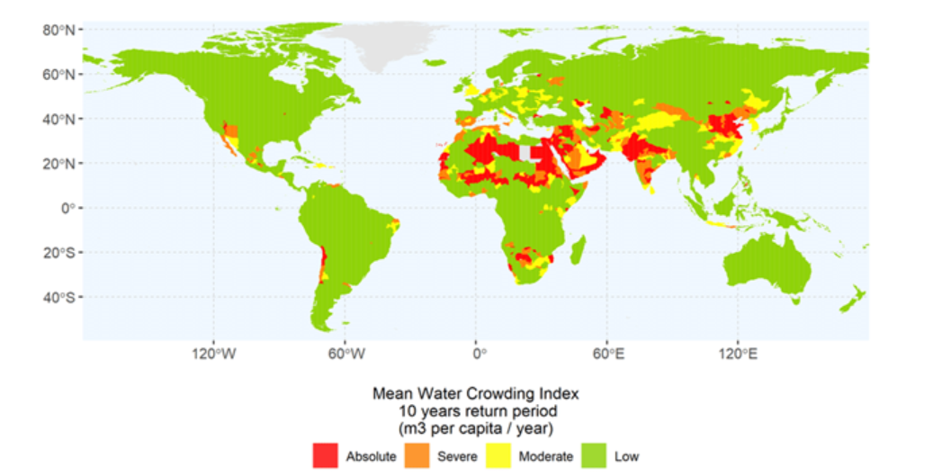
Water is the world’s most precious and exploited resource. Yet it has always been undervalued – along with the rivers, lakes, wetlands and aquifers that store and supply it. Released on World Food Day, The High Cost of Cheap Water uncovers a stark reality: the annual economic value of water and freshwater ecosystems is estimated to be $58 trillion – equivalent to 60% of global Gross Domestic Product (GDP)*. But the world’s freshwater ecosystems are in a downward spiral, posing an ever growing risk to these values.
REASONS FOR WATER CRISIS
- Climate Change and Erratic Weather Patterns: Climate change has affected precipitation patterns, leading to prolonged droughts in some areas and flooding in others.Mumbai faced massive floods in 2005, 2017, and 2019 due to intense rainfall, while states like Maharashtra simultaneously faced drought situations in their interiors.
- Over-extraction of Groundwater: Groundwater provides drinking water for over 2 billion people worldwide. However, many regions are drawing these underground reserves at unsustainable rates.The Central Water Commission reported that India can store only about 6% of its annual rainfall, a stark contrast to countries like the US, which can store up to 250%.
- Pollution and Contamination of Freshwater Sources: Industrialization, agriculture, and urbanization have led to the contamination of rivers and lakes globally. According to the United Nations, over 80% of wastewater generated globally goes untreated, leading to contamination of freshwater sources.
- Population Growth and Urbanization: The global population is increasing, putting pressure on freshwater resources, especially in urban centers. In densely populated areas like Delhi, the per capita availability of water is decreasing, leading to frequent water shortages.
- Inefficient Agricultural Practices: Agriculture consumes about 89% of India's total water resources. The cultivation of water-intensive crops like rice and sugarcane in regions with water scarcity exacerbates the problem.
CONSEQUENCES OF WATER CRISIS
- Food Security Concerns: Prolonged droughts in regions like East Africa have led to crop failures, causing famines and severe malnutrition. The World Resources Institute found that by 2050, 45 countries, including China and India, are expected to experience significant drops in crop yields due to water stress.
- Economic Impact: Industries reliant on water, like agriculture, textiles, and energy, face economic hardships during water shortages.California's drought from 2012 to 2017 led to economic losses amounting to $3.8 billion, particularly in the agricultural sector.
- Social Tensions and Conflicts: Competition over limited water resources can lead to localized conflicts and even larger geopolitical disputes.The tensions over the Grand Ethiopian Renaissance Dam among Ethiopia, Egypt, and Sudan highlight the potential for major geopolitical conflicts over water.
- Environmental Degradation: Over-extraction and mismanagement of water resources harm ecosystems and lead to habitat loss.The Aral Sea, once the world's fourth-largest lake, has lost over 90% of its volume due to water over-extraction, leading to ecological disasters and a shift in regional climate.
- Displacement of People: As water sources deplete or become contaminated, communities might be forced to relocate, leading to "water refugees.". The World Bank predicts that by 2030, water scarcity could displace more than 140 million people in sub-Saharan Africa, South Asia, and Latin America.
|
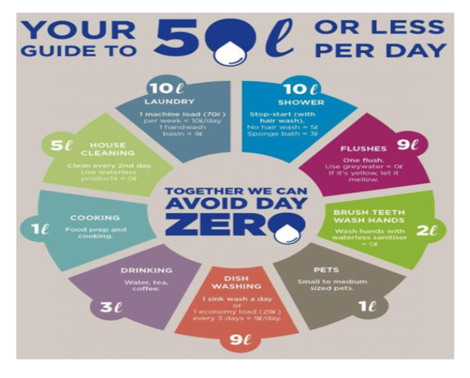
CASE STUDY : DAY ZERO IN SOUTH AFRICA The term "Day Zero" became globally recognized in 2017-2018 as Cape Town, South Africa, faced an unprecedented water crisis. Over the years, Cape Town had seen significant population growth, further straining its water resources. The city launched extensive campaigns, educating residents about the crisis and promoting water-saving measures. Thanks to a combination of stringent water-saving measures, alternate water sources, favorable rainfall in the winter of 2018, and a collective effort from its residents, Cape Town managed to push back Day Zero indefinitely. |
SITUATION OF WATER CRISIS IN INDIA
- In the 75 years since Independence, annual per capita availability of water has declined by 75%.
- Due to encroachment, India is staring at depletion of groundwater and pollution of surface water, including vanishing water bodies – ponds, lakes, tanks, wetlands.
- Provisional data from the country’s first census of water bodies shows that 2% of water bodies have been encroached.

INITIATIVES TAKEN TO MITIGATE WATER CRISIS
- Integrated Water Resources Management (IWRM): A holistic approach to managing water resources to meet social, economic, and environmental needs. India's National Water Policy of 2012 emphasizes the importance of IWRM principles, integrating water quality and quantity considerations.
- Efficient Irrigation Techniques: The Pradhan Mantri Krishi Sinchayee Yojana (PMKSY) promotes water-conserving and crop diversifying measures like drip and sprinkler irrigation.
- Rainwater Harvesting: In states like Tamil Nadu, rainwater harvesting has been made mandatory for all buildings, helping to recharge groundwater levels in Chennai and other areas.
- Desalination: Chennai has set up desalination plants like the Nemmeli Desalination Plant to augment the city's freshwater supply.
- Protection of Wetlands and Watersheds: The Chilika Lake in Odisha, Asia's largest saltwater lake, underwent restoration efforts to prevent siltation and ensure the survival of its unique ecosystem.
- Policy Reforms and Incentives:Implementing rules, pricing mechanisms, and incentives to promote efficient water use. The Maharashtra government offers subsidies for farmers adopting drip irrigation systems.
- Nature-Based Solutions: The Ahar-Pynes system in Bihar is a traditional water management system involving the construction of embankments and channels to store and direct rainwater to fields.
WAY FORWARD
- Good water management practices: Roof-top rainwater harvesting can also be utilized to recharge groundwater by digging percolation pits around the house and filling it with gravel.
- Interlinking of rivers: Interlinking of rivers is a topic that has been discussed and debated for several years as a possible permanent solution to the water crisis in the country.
- River basin authority: There should be a River Basin Authority for sharing information among states since most of the rivers in India pass through different states.
- Charging money for efficient use of water (like electricity) : For example- Water ATMs at Marathwada provide water @25 paisa per liter a day.
CONCLUSION
India is not a water deficit country, but due to severe neglect and lack of monitoring of water resource development projects, many regions in the country face water stress from time to time. Therefore balancing water demand with available supply is the need of the hour for future economic growth and development as well as for the sustenance of human life.
Where to use ?
Paper II ( Geography Optional ) : Resources , Climate change , Urbanization
Source : http://www.indiaenvironmentportal.org.in/files/file/high%20cost%20of%20cheap%20water.pdf
AEROSOLS HEATING UP HIMALAYAS
Why in news ? Indian Space Research Organization (ISRO) and the Research Institute for Sustainability have revealed that the Hindu Kush–Himalaya–Tibetan Plateau is experiencing significant warming, with aerosols playing a crucial role in this process.
About :
- Researchers discovered that aerosol concentrations have surged over the Terai areas of the Himalayas and the Ganges Plains, with pollution levels also escalating at greater elevations.
- This pioneering study utilized ground observations, satellite information, and modeling to evaluate the properties of aerosols and their radiative forcing – the alteration in atmospheric energy flow due to natural or human-made factors – across various sites in the Indo-Gangetic Plains, the foothills of the Himalayas, and the Tibetan Plateau.
- Data shows that the aerosol radiative forcing efficiency (ARFE) which shows the effect of anthropogenic aerosols on the radiative fluxes at the top of the atmosphere was significantly higher in the Himalayan foothills
- “The mean ARFE is two to four times higher here than over other polluted sites in south and east Asia, owing to higher AOD (aerosol optical depth) and aerosol absorption. Further, the observed annual mean aerosol-induced atmospheric heating rates (0.5–0.8 Kelvin/day), which are significantly higher than previously reported values for the region, imply that the aerosols alone could account for over 50% of the total warming, including aerosols and greenhouse gases, of the lower atmosphere and surface over this region
- Notably, aerosols are not only causing the region to warm up but also significantly affecting the melting rate of glaciers and altering precipitation patterns.
Impact on Asia's Population:
- The Hindu Kush-Himalaya-Tibetan Plateau spans from Afghanistan to Myanmar, encompassing nations like India, Pakistan, Nepal, Bhutan, China, and Bangladesh, making it the globe's most expansive mountain range. Directly or indirectly, it caters to the water requirements of close to 2 billion individuals, with its glacier-fed rivers being vital sources of sustenance.
- The region encompassing the Hindu Kush-Himalaya-Tibetan Plateau holds the most significant ice reserves beyond the Arctic and Antarctic zones. This area has experienced a notable shrinkage in its glaciers, which contribute to many of Asia's primary rivers.
- The Himalayas' rising temperatures have immediate consequences for nearly 2 billion Asians who depend on this region for potable water, agricultural irrigation, and energy. The research underscores that the predicament is graver than earlier estimations, with its impacts now manifesting in Asia's monsoon rhythms.
Consequences of Warming Himalayas:
International Centre for Integrated Mountain Development (ICIMOD)'s report 2019:
- It found that the Hindu-Kush Himalayas are warming faster than the global average and It highlighted that 1.5 degrees Celsius is “too hot” for the Himalayas region and consequences will be severe.
- David Molden, former director-general of ICIMOD, said that global warming of 1.5 degrees Celsius will actually mean a 2 degrees Celsius temperature increase in the mountains
- The rising temperatures in the Himalayas are destabilizing glaciers, posing a threat to areas inhabited by vulnerable communities, and increasing the risk of events like landslides. The rapid melting of glaciers contributes to untimely flooding, becoming a secondary driver for natural disasters.
Government Initiatives Related to Protecting the Himalayan Region
- National Mission on Sustaining Himalayan Ecosystem (NMSHE): Launched in 2010, NMSHE is part of India's National Action Plan on Climate Change, addressing climate challenges in the Himalayan region. Covering 11 states and 2 Union Territories, it focuses on sustainable development and conservation, safeguarding the Himalayan ecosystem.
- SECURE Himalaya Project: Funded by the Global Environment Facility (GEF), the SECURE Himalaya Project is part of a global effort to conserve wildlife and combat environmental crimes in the Himalayas. It promotes sustainable management of alpine ecosystems, benefiting biodiversity and local communities.
- Mishra Committee Report 1976: The Mishra Committee Report, named after MC Mishra, investigated land subsidence in Joshimath, a Himalayan town. It recommended restrictions on construction, blasting, and tree felling to address the issue, influencing responsible land use in the region.
What Other Measures Can Be Taken to Protect the Himalayan Ecosystem?
- Emphasis on Paris Pact and Other Global Initiatives: The Paris Pact functions as an essential bridge between political commitment at the highest international levels and the prioritization of technical assistance interventions on the ground
- Trans-Boundary Collaboration: Himalayan nations must establish an international network dedicated to monitoring and providing early warnings for risks like those stemming from glacial lakes. This network, akin to the Indian Ocean tsunami warning systems developed over the past decade, should facilitate knowledge-sharing and ecological preservation efforts across borders.
- Education and Awareness: A heightened level of awareness among Himalayan residents regarding their region's geological vulnerability and ecological delicacy would likely drive greater adherence to environmental regulations. It is imperative that India and other affected countries incorporate fundamental knowledge about Himalayan geology and ecology into their educational curricula
- Local Government Initiatives: Municipalities in Himalayan states should adopt a more proactive stance when granting construction approvals, with building regulations adapting to address the emerging challenges of climate change. Additionally, disaster management departments should pivot their strategies toward flood prevention and preparedness.
Conclusion
The study highlights the critical role of aerosols in accelerating the warming of the Himalayas, with far-reaching consequences for both the region and the millions of people who depend on its water resources.
Furthermore, the aerosols are causing significant damage to glaciers in the 2,000-kilometer-long Himalayan mountain range, which will ultimately affect the region's hydrological cycle, leading to changes in precipitation patterns and the impact of monsoons. This will have profound implications for India and the surrounding regions.
The findings suggest that the situation is even more precarious than previously believed, and urgent action is needed to address the challenges posed by climate change in this vital part of the world
Where to use ?
Paper II ( Geography optional ) : Pollution , Climate change
DROUGHT IN THE AMAZON FOREST
Why in news : Recently number of rivers have dried due to intense drought in Amazon rainforest, damaging the jungle ecosystem and having a profound impact on the indigenous communities living in that area.
About :
- The Amazon is undergoing its most severe drought ever recorded, with the Rio Negro River dropping to an unprecedented 13.59 metres. As a result, numerous fish and river dolphins have perished.
- Elevated temperatures in the Atlantic Ocean combined with El Nino effects are diminishing rainfall, exacerbating the situation.
- In October, due to the drought, the Amazon as state witnessed a surge in wildfires, tallying up to 2,700, the most in a quarter-century.
- Particularly, Indigenous communities are facing hardships, with critical shortages in basic necessities such as water and sustenance.
REASONS FOR AMAZON DROUGHT
- EL Nino Effect : El Nino results in unusual temperature increases in the equatorial waters of the Pacific Ocean.Such temperature surges can trigger intense heat phenomena globally.
- High Atlantic Ocean Temperatures: The waters of the northern tropical Atlantic Ocean are exceptionally warm. As this warmth heats the surrounding air, it shifts towards the Amazon. This elevated temperature prevents cloud formation and diminishes rainfall.
- Combined Impact of Both Phenomena: The drought gets worse when El Nino and warm Atlantic waters happen at the same time. Together, they affect a larger area of the Amazon.
Impacts of Amazon drought
- Wildlife Suffering : A significant count of fish and river dolphins, often referred to as boto, are perishing. Their decaying remains are polluting the water sources.
- Human Communities Affected: Native communities are grappling with a lack of water, food, and medical supplies.By the close of October, around 500,000 individuals might be affected.Ruth Martins, a community figurehead, highlighted the unparalleled severity of the drought
- Increase in Wildfires:Dry conditions have led to 2,700 wildfires in the Amazonas state in October, a 25-year record.Smoke from these fires has degraded air quality in Manaus, affecting residents’ health.
- Economic Impact: A major hydropower dam’s operations have halted due to the drought, impacting power supply.
What do studies say about Amazon’s future?
- Frequency of Droughts: If the combustion of fossil fuels persist at its present pace, the Amazon might confront severe drought conditions nearly annually by 2060.
- Recovery from Droughts: Over the past 20 years, the Amazon has become slower at recovering from long drought periods.
- Tipping Point: The Amazon is nearing a critical tipping point. If crossed, it could transform from a lush forest into a drier savanna.
- Deforestation Data: In the past five decades, between 17% and 20% of the Amazon has been destroyed.Experts emphasize reducing deforestation to safeguard the Amazon’s future.
Where to use ? :
Paper II ( Geography optional ) : Forests
Source : https://indianexpress.com/article/explained/explained-climate/drought-amazon-rainforest-8989382/
Kelvin wave
Kelvin wave : It is an extremely long ocean wave that propagates eastward toward the coast of South America, where it causes the upper ocean layer of relatively warm water to thicken and sea level to rise. Kelvin waves occur toward the end of the year preceding an El Niño event when an area of unusually intense tropical storm activity over Indonesia migrates toward the equatorial Pacific west of the International Date Line.
Biosphere integrity
Biosphere integrity: Biosphere integrity is considered one of the core planetary boundaries in regulating Earth system functioning. Encompassing all ecosystems and biodiversity (the variety of biological life), the biosphere interacts with the eight other planetary boundaries to maintain the planet’s capacity to continue functioning, including its ability to self-regulate and self-heal.
Glacial Lake Outburst Flood (GLOF)
Glacial Lake Outburst Flood (GLOF): It is a type of catastrophic flood that occurs when the dam containing a glacial lake fails, releasing a large volume of water. This type of flood is typically caused by rapid melting of glaciers or the buildup of water in the lake due to heavy precipitation or the inflow of meltwater.
Acid Mine Drainage (AMD)
Acid Mine Drainage (AMD): AMD occurs when sulfide minerals in the mined rocks are exposed to air and water, leading to the production of sulfuric acid. This acid can contaminate rivers, streams, and groundwater, posing a significant threat to aquatic life and ecosystem.
High Level Climate Champions (HLCC)
High Level Climate Champions (HLCC): HLCC are appointed by the United Nations to facilitate and enhance the engagement of non-state actors such as businesses, cities, regions, and investors in supporting the goals of the Paris Agreement on climate change.
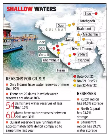
GUJARAT TRANSFORMATION FROM WATER DEFICIT TO WATER SURPLUS
- The Gujarat government created the state-level Bhaskaracharya Institute for Space Applications and Geoinformatics (BISAG) to aid in the supply of services and solutions for the deployment of map-based GeoSpatial Information Systems.
- Micro-level check dams.
- Macro-level projects particularly in the Saurashtra, Kutch, and North Gujarat areas.
- Gujarat launched the Kutch branch canal from the Narmada Main canal, which helps provide water to the most distant parts.
- Sujalam Sufalam Yojana: to irrigate the areas of North Gujarat.
- The SAUNI Yojana (Saurashtra Narmada Avtaran Irrigation Yojana), which means literally “reincarnation of the Narmada River in the region,” was thus introduced.
- Administrative and Governance reforms.
Where to use ? https://thirdworldcentre.org/wp-content/uploads/2015/05/The-Gujarat-State.pdf
Paper II ( Geography Optional ) : Government reforms , Resources
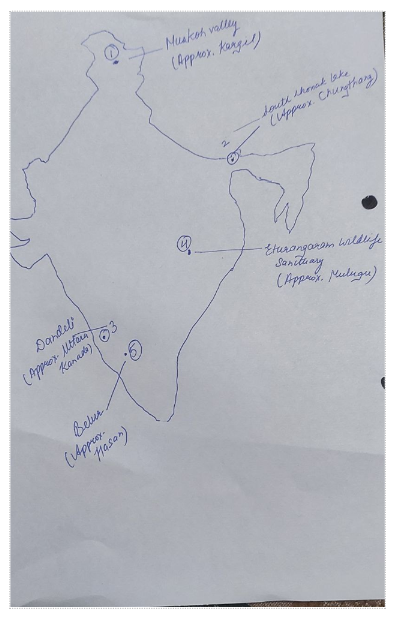
Places in News - Muskoh valley
1. Muskoh valley
Why in news : The high-altitude passes within the Gurez valley, located in northern Kashmir, are now linked to the Mushkoh valley in the Drass Sector of Kargil, Ladakh.
About :
- Located in Dras, Ladakh, the Mushkoh valley is also renowned as the “valley of wild tulips.”
- The valley gained notoriety due to the fierce battle at Tiger Hill during a conflict between India and Pakistan, resulting in numerous casualties on both sides.
- Mushkoh valley’s meadows are adorned with vibrant wild tulip flowers, and it is home to the endangered Himalayan yew.
- Approx location : Kargil
2. South Lhonak Lake
Why in news : South Lhonak GLOF triggered flood in Teesta because warnings remained neglected
About :
- It is a glacial-moraine-dammed lake, located in Sikkim's far northwestern region.
- It is one of the fastest expanding lakes in the Sikkim Himalaya region, and one of the 14 potentially dangerous lakes susceptible to Glacial lake outburst flood (GLOFs)
- Approx. location : Chungthang
3. Dandeli forest
Why in news: The Dandeli forest faces substantial environmental shifts due to changing climate patterns and human interventions.
About :
- It is located in the Uttara Kannada district of Karnataka and is part of the Western Ghats, a globally recognized biodiversity hotspot.
- The Kali Tiger Reserve is a protected area adjacent to the Dandeli Forest.
- Approx: Uttara Kanada
4. Eturangaram Wildlife sanctuary:
Why in news : Recently authorities have declared the area plastic-free zones and asked the visitors to act responsibly.
About :
- It is a wildlife sanctuary located in Eturnagaram village in Mulugu district in Telangana, India.
- The sanctuary is located near the Maharashtra, Chhattisgarh and Telangana border.
- Godavari river passes through the sanctuary. The vegetation here is tropical dry deciduous with teak and other trees . The biennial festival of Sammakka Saralamma Jatara is held in the sanctuary.
- Approx location : Mulugu
5. Belur
Why in news : Famed Hoysala temples of Belur, Halebid and Somanathapur in Karnataka have been added to the United Nations Educational, Scientific and Cultural Organization (UNESCO) World Heritage list.
About :
- Belur is situated on the banks of Yagachi River in the Hassan district of south Karnataka.
- It was also the first capital of the Hoysala dynasty, before they built Dwarasamudra (modern Halebid).
- Approx location : Hasan district
Fortnightly KOSMOS MCQs PRACTICE
Question:1 With reference to the Karman Line, consider the following statements:
1. The Karman Line represents a conceptual demarcation set 100 km above the Earth's surface, distinguishing between our planet's atmosphere and the vastness of space.
2. The Karman Line's establishment traces back to the 1960s by NASA, the space organization of the United States.
Which of the statements given above is/are not correct?
- Only 1
- Only 2
- Both 1 and 2
- Neither 1 nor 2
Question:2 Consider the following pairs:
State Tribes
1. Arunachal Pradesh a. Mismi
2. Assam b. Khasis
3. Nagaland c.Zeliang
Which of the pairs given above is/are correctly matched?
- One pair
- Two pairs
- Three pairs
- None
Question:3 The Toto dialect, used by a mere 1,600 individuals, is nearing extinction. In which region is this Toto dialect predominantly used?
- Bhutan
- Assam
- West Bengal
- Sikkim
Question:4
Which of the following protected areas are present within the Nilgiri Biosphere Reserve?
1. Mudumalai Wildlife Sanctuary
2. Wayanad Wildlife Sanctuary
3. Bandipur National Park
4. Nagarhole National Park
Select the correct answer using the code given below:
- One statement
- Two statements
- Three statements
- Four statements
Question:5 With reference to Dandeli Forest, consider the following statements:
1. Dandeli forest is located in the central part of India.
2. The Kawal Tiger Reserve is a protected area adjacent to the Dandeli Forest.
3. The invasive Eupatorium weed is replacing native grasses in the forest.
How many of the statements given above are correct?
- One only
- Two only
- Three only
- None
Question:6 With reference to the Ganga River Dolphins, consider the following statements:
1. They use ultrasonic noises to hunt, with these sounds reflecting off fish and potential prey, allowing them to form a mental picture.
2. These creatures exclusively inhabit freshwater environments and have very limited vision.
3. This species is recognized as India's national aquatic animal and also as the aquatic emblem of Assam.
How many of the above statements are correct?
- Only one
- Only two
- All three
- None
Question|:7 With reference to Tibetan Plateau in Asia,consider the following statements:
1. Tibet holds the record as the planet's most elevated area, boasting a mean altitude of 6,900 meters.
2. The peak of Mount K2 stands as the tallest point in Tibet.
3. In 2023, authorities from Tibet put their signatures on a document, under the direction of China, referred to as the “Seventeen Point Agreement.”
How many of the statements given above are correct?
- Only one
- Only two
- All three
- None
Question:8 With reference to the amphibians, consider the following statements:
1. These creatures are complex vertebrates that inhabit both terrestrial and aquatic environments.
2. They represent the initial ectothermic animals to establish a presence on land.
3. As ectothermic beings, amphibians adjust their internal body heat in response to environmental shifts.
How many of the above statements are not correct?
- Only one
- Only two
- All three
- None
Question:9 With reference to the Stratospheric Aerosol Intervention (SAI), consider the following statements:
1. SAI releases particles into the stratosphere, inducing a cooling outcome by reducing albedo.
2. SAI is a suggested approach to solar geoengineering (or altering solar radiation) with the aim of mitigating global temperature rise.
3. Moderate levels of SAI might boost agricultural output in mid-latitude zones such as North America and Eurasia.
How many of the above statements are correct?
- Only one
- Only two
- All three
- None
Question:10
With reference to the Dancing Frogs, consider the following statements:
1. Dancing frogs refer to a set of frogs from the Micrixalus genus.
2. The number of dancing frogs is declining due to introduction of non-native mosquito species
3. These frogs favor areas with dense overhead foliage and are commonly located near gently flowing year-round streams in the Western Ghats.
How many of the above statements are correct?
- Only one
- Only two
- All three
- None
Question:11 Consider the following statements with respect to ‘UN-Habitat’:
1. It's an initiative that supports the development of human settlements in an environmentally and socially sustainable manner, aiming to ensure suitable housing for everyone.
2. The theme of the World Habitat Day, 2023 is “Resilient Urban Economies. Cities as drivers of growth and recovery”.
3. The UN-Habitat Scroll of Honour award is presented during the worldwide commemoration of World Habitat Day.
How many of the above statements are correct?
- Only one
- Only two
- All three
- None
Question:12 Consider the following states:
1. Haryana
2. Punjab
3. Himachal Pradesh
4. Delhi
How many of the above states are associated with Sutlej Yamuna Link (SYL) Canal?
- Only one
- Only two
- All three
- None
Question:13 With reference to Gaza Strip, consider the following statements:
1. The Gaza strip is bordered by Lebanon to the southwest and Israel on its northern and eastern sides.
2. The phrase “ open air prison “ is frequently employed by scholars to describe the situation in Gaza.
Which of the statements given above is/are correct?
- Only 1
- Only 2
- Both 1 and 2
- Neither 1 nor 2
Question:14 With reference to the Baiga tribe, consider the following statements:
1. Their primary residence spans states like Chhattisgarh, Jharkhand, Bihar, Odisha, West Bengal, Madhya Pradesh, and Uttar Pradesh.
2. Tattooing holds significant cultural value for the Baiga, with specific tattoos designated for different ages and body regions based on the occasion.
Which of the statements given above is/are correct?
- Only 1
- Only 2
- Both 1 and 2
- Neither 1 nor 2
Question:15 With reference to the Ken river, consider the following statements:
1. It originates in Madhya Pradesh (MP) and is the tributary of Yamuna.
2. Rajghat, Paricha and Matatila dams are over Ken river.
3. Ken River passes through Panna tiger reserve.
How many of the statements above are correct?
- Only one
- Only two
- All three
- None
Share the article
Edukemy’s Current Affairs Quiz is published with multiple choice questions for UPSC exams
MCQ
Get Latest Updates on Offers, Event dates, and free Mentorship sessions.

Get in touch with our Expert Academic Counsellors 👋
FAQs
Geography Current Affairs focuses on the contemporary issues, events, and developments in the field of geography. It covers recent geographical phenomena, environmental changes, geopolitical shifts, and related news. This differs from regular geography studies which may focus more on foundational concepts, historical contexts, and theoretical frameworks.
Updates are provided regularly to ensure that subscribers stay informed about the latest developments in geography. Typically, updates are provided on a fortnightly basis, depending on the frequency of significant events and changes in the field.
Absolutely. Geography Current Affairs serves as a valuable resource not only for Geography optional but also for GS papers, especially GS Paper 1 (covering Indian Heritage and Culture, History, and Geography of the World and Society) and GS Paper 3 (covering Technology, Economic Development, Biodiversity, Environment, Security, and Disaster Management). It aids in building a holistic understanding of various topics and strengthens answer-writing skills by incorporating contemporary examples and perspectives.
Geography Current Affairs holds immense importance for UPSC preparation, particularly for aspirants opting for Geography optional. It helps candidates stay updated with the latest developments, geographical phenomena, environmental issues, and geopolitical shifts worldwide, aligning them with the dynamic nature of the subject as tested in the UPSC examinations.

