29 Jan
Inequalities & Disparities in India- A persistent challenge which needs urgent redressal
In news: According to recent World Inequality Report 2022, India is amongst the most unequal countries in the world.
Background:
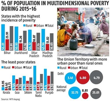
- India is facing the problem of acute regional imbalances which is reflected in the factors like per capita income, the proportion of population living below poverty line, low income of population engaged in agriculture, the percentage of workers engaged in industries, infrastructural development, urbanization etc.
- In India, the top 10% and top 1% hold 57% and 22% of the total national income respectively while the share of the bottom 50% has gone down to 13%.
- A economically backward region is impacted by the factors like excessive pressure of population on land, too much dependence on agriculture, high incidence of rural employment and high degree of under-employment, low productivity in agriculture, under urbanization, absence of basic infra-structural facilities etc.
- A persistent regional inequality linked to lack of convergence in income across regions is associated with a rise in conflict and social unrest and poor socio-economic indicators.
- Thus there is urgent need to address persisting regional inequality in India for sustainable and balanced regional development.
Inequalities in India- a regional perspective:
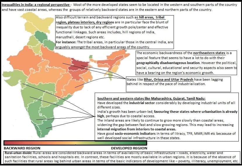
Reasons associated with persisting inequalities in India:
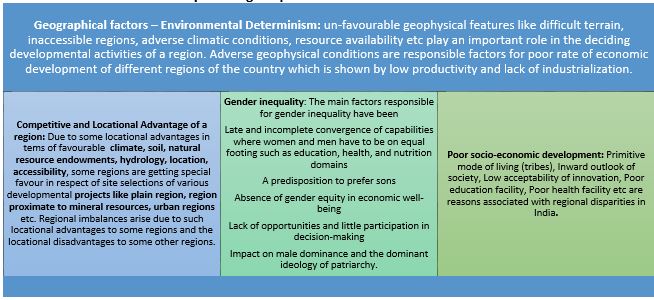
- Deliberate unbalanced development planning: Regional imbalances in India started from its British regime. British industrialists mostly preferred to concentrate their activities in port proximate cities like Kolkata, Mumbai neglecting the rest of the country to remain backward. This trend was carry forward in post independence strategies such as growth pole based planning like Green Revolution planning, neglect of tribal regions The uneven pattern of investment had resulted in uneven growth of some areas keeping other areas neglected.
- The main cause of regional backwardness and disparities has been the strong backwash effect and weak spread effect as per Gunnar Myrdal Cumulative Causation Theory: Developed region develops at faster rate at a cost of backward region. Due to lack of functional linkages in terms of social and physical infrastructure, development from developed region is not reinvested in backward regions but is repatriated to the developed sector/region- leading more development in developed regions and deepening already existing inequalities. Thus spread effect continues to become strongest in developed regions and backward effect continues to become even more spread in backward regions.
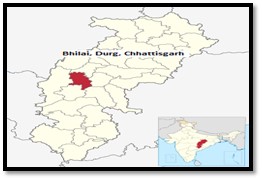
Case study: Bhilai – modern steel plant: an island of development
It stands as monuments of national achievement but regional failure. The impact of this projects on the regional economy has, however, not been spectacular and the so called leading industry failed to generate development impulses in the hinter land. In their immediate regional environment, there is hardly any spread effect. Region has attracted factors of production and has emerged as an island of developed town, but the surrounding areas have been desertified in terms of growth and development.
Need for urgent redressal of inequalities:
- To arrest aggregation of the imbalance: Once an area is prosperous and has adequate infrastructure for development, it acts as sunction pump wherein more investments pour-in neglecting the less developed regions. Thus balanced regional development is needed for reduction of regional disparities in the distribution of income, wealth and development. For examples, the growth of the metropolitan cities like Mumbai, Delhi, Kolkata, Chennai, Bangalore and Hyderabad is higher compared to other cities and regions of India.
- To minimise backwash effects: According to Gunnar Myrdal, the regional disparities in India have been caused by the strong backwash effects and weak spread effects. The profit motive in a capitalist system accentuates disparity by the free play of market forces. So, India should endeavour to minimise the backwash effects through deliberate state intervention.
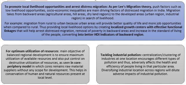
Way forward for balanced regional development:
- Application of regional development principles in regional planning:

- Create a positive narrative of development by making development a mass movement: as people is the most valuable resource to improve a region’s performance. Changes in people’s mind-sets and attitudes are critical to achieve progress.
- Growth Corridors comprised of education zones, agricultural and industrial zones should be operationalized for the rapid development of backward areas.
- Additional funds for Infrastructure: Additional funds to build core infrastructure at the inter-district level in less developed States and backward regions.
- Schools for providing free and compulsory education to remove illiteracy.
- Hospitals and dispensaries to give medical care to the people.
- Water facilities for domestic purposes and agriculture.
- Cottage and small industries to provide employment opportunities.
- Roads and railway lines to link different places.
Regional imbalance is threat to the goal of inclusive growth and reduction of poverty. The growing regional disparities have dampened the further economic reforms, and hence may pose a barrier to India’s future economic growth. Regional disparities will result in regional tensions, which may lead to popular agitations and militant activities. Regional disparities have created and creating demand for separate States like in the past for separate Telangana and now and then for Vidhrbha and for Bodo land. As such, there is a strong need for strengthening of good governance in the backward areas. It is necessary that the local bodies in the backward areas are empowered and strengthened to reduce the regional imbalances in the country.
Climate change impacting livelihoods in the cold desert of India
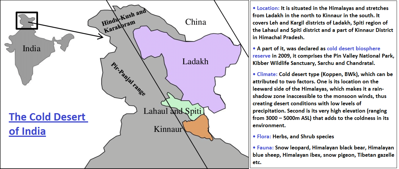
Evidences of climate change in the cold desert of India:
- Reduced snow cover: In Spiti valley, usually November would bring with it the season’s first snowfall and by March, there would be a healthy snow cover of 1.5 m. Last winter season (November 2020-April 2021), the snowfall started as late as March and by April, the snow cover was only 0.5 m, which melted as soon as it fell.
- According to a report published by the Himachal Pradesh Centre on Climate Change, the area under snow cover in the state has declined by 18.5 percent & revealed a decreasing trend of snow cover in all the four major river basins in the state (Ravi, Sutlej, Chenab and Beas). This is also seen in the migration of snow leopards to plain areas.
- Changing precipitation patterns: The annual rain in form of snowfall in the two cold desert districts of Himachal Pradesh- Lahul-Spiti and Kinnaur- has significantly decreased over the past three decades (1989-2018). A significant decrease means more than 95 per cent weather monitoring stations in the districts have recorded a downward rainfall trend.
- This in turn has affected the traditional springs, which have remained dry for years because of the dipping precipitation levels. Many villages now rely on artificial glaciers to keep the springs alive.
- Increasing temperature: The average annual temperature has increased in Ladakh in the past three decades, the precipitation level has progressively gone down.
- In 2016, Researchers have found “a rapid and significant temperature increase over Leh in 1991-2013 after a short period of cooling between 1979 and 1991. The current two decades (1991-2013) show a significant and steep increase in the temperature over Leh, possibly foreshadowing further warming of the environment over the region.
- The impact of the changing temperature can be seen in the glaciers. The Pensilungpa glacier in the Zanskar Valley Ladakh’s Kargil district had shrunk by 36 per cent between 1962 and 2012.
- Changes in migratory patterns of avifauna: Some changes in migration patterns of birds have been noticed in villages and also at Tsomoriri Lake (as reported by WWF and wildlife warden). Migratory birds like Red-Shell dock used to leave Ladakh long before the harsh winters of this cold desert, now some of them have become residents.
- However, some other migratory birds like the geese, Brahmini duck have stopped migrating outside; they are found in the region throughout the year. Likewise, the breeding of bar-headed goose and black-necked crane is declined and not on schedule in recent years.
How climate change is impacting the livelihoods in the cold desert of India?
- Impact on agriculture: Changing precipitation and melting glaciers are impacting farming, which is already difficult in the harsh climatic conditions of cold desert of India.
- The harvesting season of green pea crops in the cold deserts of Himachal Pradesh is progressively getting delayed due to changing precipitation patterns.
- The agriculture season in Ladakh begins in April with the melting of snow in fields. Due to climate change, the melting of snow is often late, delaying the availability of water for irrigation and the sowing of crops, thereby, adversely affecting the production.
- Almost 80 per cent of the glaciers in the Ladakh region are very small but are critical as local communities are entirely dependent on glacier and snow melt. Due to inadequate winter precipitation, there is negative mass balance of glaciers in the last two decades. Because of this, the region faces drought like conditions during early cropping season.
- Impact on livestock rearing: Most of the families in this region own livestock including yaks, cows, sheep, goats and donkeys. Earlier fodder was easily available here but now people have to travel 5-6 km for it as the natural vegetation has changed & the amount of fodder decreased due to changing temperature and rainfall patterns.
- Extreme weather events: The events of cloud bursts are on the rise. On July 27, 2021, the Udaipur sub-division in Lahul recorded an unprecedented 20.8 mm rainfall that triggered a flashflood which washed away most of the bridges in the district.
- Leh and its surrounding mountain regions were also experiencing short bursts of rainfall in September, which is abnormal as the monsoon season occurs between May and August.
- Impact on biodiversity: Mountain species are especially vulnerable, due to their limited ranges, geographic isolation and specific adaptations.
- Melting glaciers are expected to change moisture availability, which governs physiology, metabolic and reproductive processes, phenology, tree-line positions, and the geographic distribution, which in turn will affect the livelihoods of people in this region.
- Impact on settlements: Little or no economic diversification, strong dependence on few resources, remoteness and extreme weather conditions make this region and its people more vulnerable to climate change. This will impact settlements in ways such as loss of livelihood, displacement of people and distress migration to urban areas and increased risk of death and loss of property due to extreme events etc.
Way forward:

Where it can be used?
It can be used in topics related to Paper 1 (Climate Change, Sustainable Development, Biodiversity) and Paper 2 (Climatic regions, Agriculture, Hill area development, sustainable growth) and GS3 (Environmental degradation).
Sources
Red Sanders smuggling in India- A grave threat to biodiversity
Why in news: Red Sanders (Red Sandalwood) has fallen back into the ‘endangered’ category in the IUCN Red list (It was classified as ‘near threatened’ in 2018 and has now joined the ‘endangered’ list once again in 2021).

Detailed geographical extent of Red Sanders:
- The Red Sanders has a restricted geographic range in the Eastern Ghats where the species is endemic to a distinct tract of forest in the Rayalaseema region of Andhra Pradesh.
- It is estimated that about 15.5 lakh harvestable trees may be found in the Red Sanders bearing forests, of which 1.6 lakh hectares (1,600 sq km) comes under the Protected Area Network of Andhra Pradesh. It is roughly estimated that about 9 lakh trees are in the reserve forest areas outside the protected areas.
- The species is also cultivated in very small numbers in Kerala, Maharashtra, Gujarat, Karnataka, Telangana, Tamil Nadu, Odisha and West Bengal within India, as well as in Sri Lanka and China.
Red Sanders smuggling in India & How it is a grave threat to biodiversity?
- Demand-supply imbalance: While supply is so restricted, the market demand for Red Sandalwood is about 1,000 metric tonnes per year, according to forest department data. This imbalance has fuelled the massive illegal trade in Red Sanders, all the more since its export from India is severely restricted.
- Declining numbers: According to the IUCN, over the last three generations, the species has experienced a population decline of 50-80%. The maturity period for Red Sandalwood trees is 12-15 years. The slow growth of the species and continued harvesting leaves no time for the species to recover naturally.
- Threat to biodiversity: Red Sanders is dwindling in its natural habitat due to over-exploitation. This habitat loss negatively influences biodiversity directly through its impact on species abundance, genetic diversity, species richness, species distribution and ecosystem services. And, on a whole, it will impact the health of ecosystem.
- Other threats: Forest fires also pose a significant threat to the Red Sandalwood trees. According to the Institute of Forest Genetics and Tree Breeding (IFGTB), the natural Red Sanders areas are highly prone to summer fires but the thick dry grasses and difficult terrains make it difficult to control such disasters. A little over a thousand forest fires are reported every year in Andhra Pradesh. Cattle grazing and invasive species also threaten the species.
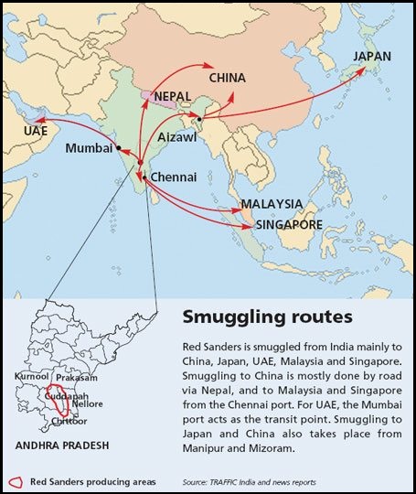

Measures in place to tackle the menace of Red Sanders smuggling in India:
- The State/UT Governments dwell in to the Protection and Management of Forests and the action to tackle illegal felling of trees is taken as per the provisions contained in the Indian Forest Act, 1927; Wildlife Protection Act, 1972; Forest Conservation Act, 1980 and also as per the various state specific rules & regulations thereof.
- In order to check the smuggling of Red Sanders in a comprehensive way, the Government of Andhra Pradesh has created a separate wing for containing Red Sanders smuggling which is monitored at a senior level.
- The field formations units of the Directorate of Revenue Intelligence (DRI) have been sensitized to prevent the smuggling of all Rare/Endangered Species of Flora and Fauna from Indian precious Forest Wealth.
Way forward:
- Remote Sensing and Geographical Information System can be effectively utilized to understand Red Sanders bearing forest for objectives of conservation, tree improvement and legal commerce.
- Local communities and village people should be sensitized about the issue and habitats must be protected in situ conservation. Likewise, the gene sanctuaries must be granted protection and constant surveillance.
Where it can be used?
It can be used in topics related to Paper 1 (Distribution of plants and animals, Conservation measures, gene pool centres, Biodiversity Conservation), Paper 2 (Forest and wildlife resources and their conservation, Cross border trade) and GS 3 (Management of border areas).
Sources:
GLOF
A glacial lake outburst flood (GLOF) is a release of melt water from a moraine-dam or ice-dam glacial lake due to dam failure.
Ex. The Kedarnath tragedy in 2013, for example, had involved a breach in a large glacial lake. Glacier burst in the Chamoli district of Uttarakhand.
How does it occur? - When glaciers melt, the water in glacial lakes accumulates behind loose, natural “glacial/moraine dams” made of ice, sand, pebbles and ice residue. Unlike earthen dams, the weak structure of the moraine dam leads to the abrupt breach of the dam on top of the glacial lake which could cause flash floods in the downstream areas.
An event similar to a GLOF, where a body of water contained by a glacier melts or overflows the glacier is called a jökulhlaup.
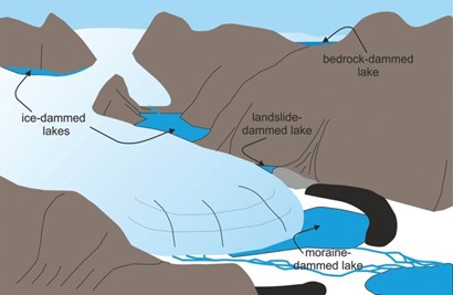
Fig1: A GLOF -boundaries of the lakes are breached, for the flooding to occur downstream of that glacial lake.
Features:
- They involve sudden (and sometimes cyclic) releases of water.
- They tend to be rapid events, lasting hours to days.
- Furthermore, they result in large downstream river discharges (which often increase by an order of magnitude).
Causes:
- A buildup of water pressure or structural weakness of boundary due to an increase in the flow of water.
- An earthquake (Tectonic) or cryoseism(non-tectonic seismic event of the glacial Cryosphere) can also cause GLOF. During this, the boundary of the glacial lake will collapse suddenly and release the water in the glacial lake.
- An avalanche of rock or heavy snow: During this, the water in the glacial lake might be displaced by the avalanche
- Volcanic eruptions under the ice can also cause GLOF. These volcanic eruptions might displace the boundary or increase the pressure on glacial lake or both.
- Heavy rainfall/melting of snow: This can lead to massive displacement of water in a glacial lake.
- Long-term dam degradationcan also induce GLOF.
Sources:
Cuesta
Cuesta also called Homoclinal Ridge is a gently sloping ground formation that has a steep cliff or escarpment on one side and a gentle dip or back slope on the other as shown in the figure 1 below.
Features:
- They occur in areas of tilted strata. They can be found in some plains regions. They occur more often near an ocean or large body of water.
- In essence they develop in tabular, weakly dipping beds under the action of differential dissection which erodes the weak beds on the high points of folds, the resistant beds at a lower structural level persisting.
- They are caused by the differential weathering and erosion of the hard capping layer and the soft underlying cliff maker, which erodes more rapidly.
- Cuestas with dip slopes of 40°–45° are usually called hogback ridges.

Figure 1: Cuesta Topography
They are common in the United States, notably in Arizona and New Mexico and along the Atlantic and Gulf coasts.
Where it can be used? Geography paper 1 - Geomorphology
Sources:
Wildlife Protection Act
Why in News? -The amendment to Indian Wildlife (Protection) Act, 2021, was introduced and passed in the Lok Sabha and has been referred to a Parliament committee recently. The bill seeks to amend the Wild Life (Protection) Act, 1972 for better implementation of the Convention on International Trade in Endangered Species of Wild Fauna and Flora (CITES).

What changes are being proposed to the wildlife law?
- The Bill aims to decentralize wildlife protection, with the establishment of Standing Committees of State Boards of Wildlife, which can regulate permissions to various projects based on their impact on the wildlife, without having to refer to the National Board for Wildlife.
- The bill also aims to streamline the schedules mentioned in the original Act, shrinking them from six to four.
- Additionally, Wildlife Management Plans crafted for wildlife sanctuaries and parks in the country will be brought under the jurisdiction of the Act, thereby increasing the scope for stricter protection for various species. These were earlier governed by the government in charge.
- Bill will help India meet the provisions of the Convention on International Trade in Endangered Species of Wild Fauna and Flora (CITES), which is an international treaty regulating the safe trade of animals and plants across international borders.
- It opens an era of protection for the aquatic/marine mammals, reptiles, fishes and other invertebrates since the wildlife wing has to take action to monitor coasts to safeguard marine fauna, hitherto neglected.
In conclusion, the amendments are more technical and the need of the hour is to plug loopholes in the field of wildlife protection, conservation, and management.
Sources:
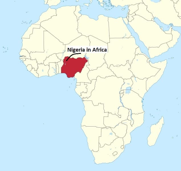
Nigeria: Using Gender Mainstreaming Processes to Help Protect Drinking Water Sources of the Obudu Plateau Communities in Northern Cross River State
- About Obudu plateau:
- The Obudu plateau is one of two mountain ecosystems in Nigeria and is home to tropical forests with unique flora and fauna, as well as large pastures.
- The top of the plateau is also home to the Becheve agricultural communities and the Fulani pastoralists.
- Challenges:
- Large-scale construction of hotel and other facilities resulted in immense deforestation.
- Combined with pre-existing pressures on the environment, such as overgrazing and unsustainable agricultural practices, the development exacerbated the stress on available water resources.
- Conflicts arose due to the multiple demands on a limited water supply.
- The Becheve women complained about poor family health, wasted time in collecting water, and poor quality and quantity of water.
- Programme:
- The Nigerian Conservation Foundation (NCF), a NGO, started a Watershed Management Project.
- The NCF has mainstreamed gender concerns into its organizational policies and priorities nationwide.
- Using participatory approaches, the necessity of women’s involvement was systematically championed throughout the project cycle. They were included at every stage, in the design, implementation and monitoring of the project.
- The NCF used the meetings as a forum to educate the communities about participatory watershed management and the dangers of unsustainable practices to ecosystems, as well as to sensitize the Becheve communities and Fulani herdsmen on their gender biases and the important role of women in collecting water for families.
- This resulted in understanding that handmade wells may not be secure sources of potable drinking water. They also accepted that household connections would benefit the community at large, both women and men.
- Outcome:
- Increased involvement: guaranteed greater women’s participation (56 per cent) in water management. Once the water systems were installed, the female leadership with its capacity and quality moved to other initiatives.
- Education: The methodology utilized in the education and training component increased the knowledge and the information levels of women living in rural areas, who were previously in a disadvantaged position.
- The awareness levels gained by a large part of the population, especially rural women, contributed to achieving a significant participation in different cycles of the project of young, middle-aged and elderly women, including mothers with numerous responsibilities.
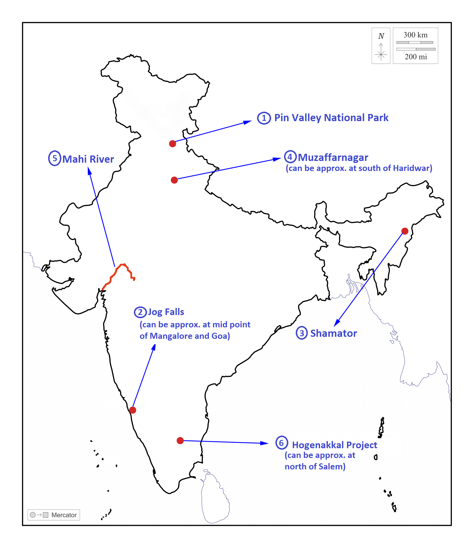
Places in news
|
Pin Valley National Park
|
|
Jog Falls
|
|
Shamator
|
|
Muzaffarnagar
|
|
Mahi River
|
|
Hogenakkal Project
|
Share the article
Get Latest Updates on Offers, Event dates, and free Mentorship sessions.

Get in touch with our Expert Academic Counsellors 👋
FAQs
Geography Current Affairs focuses on the contemporary issues, events, and developments in the field of geography. It covers recent geographical phenomena, environmental changes, geopolitical shifts, and related news. This differs from regular geography studies which may focus more on foundational concepts, historical contexts, and theoretical frameworks.
Updates are provided regularly to ensure that subscribers stay informed about the latest developments in geography. Typically, updates are provided on a fortnightly basis, depending on the frequency of significant events and changes in the field.
Absolutely. Geography Current Affairs serves as a valuable resource not only for Geography optional but also for GS papers, especially GS Paper 1 (covering Indian Heritage and Culture, History, and Geography of the World and Society) and GS Paper 3 (covering Technology, Economic Development, Biodiversity, Environment, Security, and Disaster Management). It aids in building a holistic understanding of various topics and strengthens answer-writing skills by incorporating contemporary examples and perspectives.
Geography Current Affairs holds immense importance for UPSC preparation, particularly for aspirants opting for Geography optional. It helps candidates stay updated with the latest developments, geographical phenomena, environmental issues, and geopolitical shifts worldwide, aligning them with the dynamic nature of the subject as tested in the UPSC examinations.

