
25 Dec
Need of Second Green Revolution for revival of Indian Agriculture
Introduction
- The first Green Revolution in the 1960s characterized by the use of high-yielding varieties and more intensive farming techniques transformed the agricultural landscape in the country.
- It played a key role in preventing mass starvation and hunger deaths in India in the face of a growing population and an increasing food demand.
- However, its non-sustainable nature coupled with its limited scope and subsequent impact on the ecosystem, have led to a quest for a more sustainable and greener alternative.
- Therefore we need Second Green Revolution that should be in accordance with regional potential of India bases on Agro-climatic regionalization.

The Green Revolution - I
- The positive impact of green revolution were tremendous increase in food produce, reduce imports of food grains as India became self sufficient and was in a position to export food-grains, helped the farmers in raising their level of income, Industrial growth and rural employment.
- The negative impact of green revolution were Non-Food grains such as coarse cereals, pulses and oilseeds were left out of the ambit of the revolution, High Yielding Variety Programme (HYVP) was restricted to only five crops: wheat, rice, jowar, bajra and maize, regional disparities(Geographical focusconcentrated in the northern part of the country, especially Punjab, Haryana, western UP and northern Rajasthan), excessive usage of chemicals, crops were water-intensive, repeated crop cycle depleted the soil's nutrients, except in Punjab and to some extent in Haryana farm mechanization created widespread unemployment, the large-scale use of chemical fertilizers and pesticides resulted in a number of critical health illnesses.

Need for the Second Green Revolution
- Key economic indicators of agricultural sector: Agriculture is the primary source of livelihood for about 58% of India’s population. However, share of agriculture and allied sectors in gross value added (GVA) of India at current prices stood at only 17.8 % in FY20.
- Cropping pattern and Productivity:
- Currently only around 45.5% area of the country is under Net own Area (NSA) and there is scope to increase the NSA by at least 5 to 10 percent by improving both cultivable waste land and fallow.
- The agricultural systems in India have become increasingly reliant on rice and wheat impacting crop diversitythat does not augur well for the food and nutritional security of the country.
- The rank of India in yield rate is much poor although it happens to be one of the top producers of the agricultural commodities across the globe. Raising the productivity of agricultural commodities per unit of land has remained one of the top concerns in the sector.
- The regional disparity exists owing to the availability of fertile lands and water availability. Production also varies accordingly, with states like Punjab and Haryana, with its fertile lands and rivers showing high productivity, while the eastern states show low figures.

- Land holding pattern:
- The number of operational holdings, i.e. land put to agricultural use, has increased from 13.8 crores in 2010-11 to 14.6 crores in 2015-16 as per the Agriculture Census 2015-16.
- The average size of landholding contracting at a time when the share of agriculture in GDP is going down, coupled with increasing fragmented cropping areas and large number of small and marginal farmers will have a detrimental impact for the sector.

- Water Use in Agriculture:
- Rainfed Agriculture:Water required for irrigation purpose is estimated at around 75-85 per cent share in the total demand. Around 52% of India’s cultivated land is dependent on monsoon rains. The mean productivity of rainfed area) is about 1.1 tonne per ha compared to 2.8 tonne per hectare of irrigated area.
- Sub-optimal utilization of irrigation:The reported gap between Irrigation Potential Created (IPC) and Irrigation Potential Utilized (IPU) in India is as large as 25.6 m ha, with a cumulative irrigation potential of 87.9 m ha utilized against 113.5 m ha created in 2015.
- Water intensive cropping pattern:The issue of water availability in agriculture is aggravated especially when the cropping systems are becoming more resource intensive with focus on rice, wheat and sugarcane
- Technology diffusion:The overall level of farm mechanization in the country is only 40-45% compared tothe US (95 %), Brazil (75%) and China (57%). Moreover, according to a Planning Commission review, the low productivity has been due to a non-responsive agricultural research, broken down extension and inadequate seed production, distribution and regulation.
- Climate changes: This would lead to more frequent hot extremes, floods, droughts, cyclones, and recession of glaciers, leading to the loss in agricultural revenue. Dynamics of pests and diseases would be significantly altered. The productivity of crops will be affected and the projected increase in these events will result in greater instability in food production and will threaten the livelihood security of the farmer.
- Problem of Pests and Diseases:In India, the farmer’s crop yield losses range from 15- 25 per cent owing to the presence of weeds, pests, diseases and rodents. The intensity of pesticide usage is high in case of certain crops, particularly when raised in irrigated systems. High usage of chemical pesticides also impacts health and safety of other flora and fauna, including humans.
- Other challenges:There are various challenges such as post harvest losses, slow income growth, land degradation and desertification, problems related to agricultural credit and value chain. Policy risks are also there in agriculture.
Pathways to the next Green Revolution- the Evergreen Revolution
- While the first revolution focused on production, the next green revolution should focus on improving productivity by utilizing the advancements in technology, from the limited asset of lands and decreasing natural resources without harming the ecology.

- In a nutshell, the next big thing in Indian agriculture should be an evergreen, sustainable revolution. The term “evergreen revolution” denotes sustainable advances in crop productivity per unit of land, water, and time, without associated ecological harm. It involves a paradigm shift from a commodity centric to a “systems approach”.
- Evergreen Revolution addresses:
- The ecological foundations (soil health, biodiversity, water, renewable energy) of agriculture
- Conservation and enhancement of biodiversity in general, and the agro biodiversity in particular
- Linking livelihood security with ecological security
- A “bottom-up” participatory approach in achieving productivity in perpetuity without ecological harm
- Community-centered approaches for conservation and sustainable use of Natural resources especially water with social and gender equity
- Technological and knowledge empowerment of the resource poor, largely illiterate, and unskilled rural women and men to embark on a path of sustainable livelihoods

The pathway to a holistic evergreen revolution involves integration of several scientific, technological, social, environmental, gender and ethical aspects. Thus keeping in view the above mentioned facts the following policy measures should be adopted for sustainable growth in Indian agriculture:
- Technological breakthrough: Adoption of existing HYV technology has reached its limit. Therefore, future pace of agricultural growth will be slow, unless there is further technological breakthrough by way of HYVs, hybridization, tissue culture, genetic engineering, etc.
- Location specific crops: There is still a vast acreage of land under local varieties for most of the cereal crops due to various agro-climatic constraints, which demands an evolution of location specific suitable varieties for such lands.
- Adequate infrastructural support in terms of irrigation, credit, market, road, delivery services, etc. would be essential. Increasing production efficiency depends on research in BioTechnology, genetic engineering, promotion of better utilization of irrigation capacities, better conservation of rain water, minimization of salinity and water logging problems and improvement in rural infrastructure facilities like power, roads, post-harvest infrastructure etc.
- Prioritized Agriculture: As poor families mostly own degraded and low fertile lands, deprived of irrigation, the focus should be on efficient use of such lands. As such lands are not suitable for intensivecropping of high yielding food and cash crops, priority should be given to dry land, horticulture and agri-silvi pastures.
- Good Agricultural Practices: In order to have sustainable agriculture and hence sustainable development of India organic farming along with scientific inputs is required. Agro-forestry on Degraded Lands, Farming on Wastelands, Eco-agriculture, Green Agriculture, White agriculture and One-straw Revolution etc. are required.
- Inclusive rural development: The second green revolution should focus on generation of employment for the small and marginal farmers and the landless, while enhancing agricultural production.
|
Key Government Initiatives
- "Green Revolution – Krishonnati Yojana" is an the Umbrella Scheme in agriculture sector that has been implemented since 2016-17 by clubbing several schemes / missions under one umbrella scheme. The scheme has now been continued for the period from 2017-18 to 2019-20.
- Bringing Green Revolution to Eastern India (BGREI), a sub scheme of Rashtriya Krishi Vikas Yojana (RKVY) is being implemented in seven eastern states namely Assam, Bihar, Chhattisgarh, Jharkhand, Odisha, Eastern Uttar Pradesh and West Bengal. Under the programme, assistance is being provided to the farmers for organizing cluster demonstrations on rice and wheat, seed production and distribution, nutrient management and soil ameliorants, integrated pest management, cropping system-based training, asset-building such as farm machineries & implements, irrigation devices, site specific activities and post harvest& marketing support, etc.
- NITI Aayog’s 3-year Road Map (2017-20) for ‘Evergreen Revolution’: The roadmap lists initiatives such as o harvest the advantages of space technology in agriculture and allied sectors, promotion of deep sea fishing, setting up of seed production and processing units at ‘panchayat’ level, increase of cropping intensity by 1 million hectares per year etc. for the growth of farm sector and for ensuring that farmers’ income doubles by 2022.
Conclusion
Unlike the green revolution, the pathways of the evergreen revolution address concurrently the famine of food and the famine of livelihood. Thus, it is integrated with sustainable rural development through technological and knowledge empowerment of rural communities. Moreover the Second GR must address the six deficits in Indian agriculture. These are: investment, credit and infrastructural deficit; research and extension (technology) deficit; market deficit; diversification deficit; institutions deficit; and education/skill deficit.
Where it can be used: Paper-1: economic geography, Paper-2: agriculture, resources
Need for Compact Area Development of NCR
Why in news: The National Capital Region Planning Board (NCRPB)in its ‘Draft Regional Plan 2041’ has proposed to limit the NCR region to 100 km radius from Rajghat, Delhi for focused and sustainable development of the region.

Why there is a need for Compact Area Development of National Capital Region (NCR)?
- Haphazard Outward Expansion: Over the last five decades, despite the existence of three master plans for Delhi and two regional plans for NCR, the regions has witnessed an unplanned spatial growth as a border-less city. This has led to peri-urban conditions “characterized by fragmented development, the emergence of gated communities, sudden densification of existing settlements” with “inadequate physical infrastructure, absence of public transport or road connectivity and general lack of physical and social infrastructure”.
- Failed policies: The NCRPB drew up its first Regional Plan (2001) in 1989. It was meant to deflect the population from Delhi, by 2001, through a multi-nodal regional growth pattern. Eleven dispersed growth centres were identified outside of NCT including Noida, Faridabad, Gurgaon, and Ghaziabad among several others. However, the population of NCT -Delhi continued to grow exponentially more than what was planned.
- To reduce urban sprawl: Compact area development reduces the sprawl phenomenon bymaximizing the land use in cities, for instance, via redevelopment of abandoned and vacant properties, green development on the urban periphery can be avoided. Hence it helps in countering the negative consequences of urban sprawl such as traffic congestion, loss of productive agricultural lands, air & water pollution and social fragmentation
- To increase economic efficiency in delivering basic urban services: Utilities service can be delivered cost-efficiently in more densely populated areas. Due to the economies of scale in supplying energy, water and treating waste, it is less costly to deliver urban utilities service in compact cities than in suburban
- Social sustainability:In compact cities, decreased road length improves mobility, reduces travel time and promotes walkable and pedestrian-friendly environments. Also compact cities are safer & compactness promotes social cohesion and cultural development.
- Environmental Sustainability: Compact area development leads to less car dependency hence reduced GHG emissions and micro-climate development. Also, it will reduce the pressure on ecosystem services and biodiversity provided by green and natural areas.
|
Case Study: Compact area development- Toyama City, Japan
|
Way forward:
- Apart from Compact area development, other sustainable urban development approaches include- Neo-traditional development, urban containment, eco-city, garden city, landscape urbanism All of them will help in achieving the goals under SDG 11, SDG 3 and SDG 13.

- However, Compact cities involve a number of problems and challenges when it comes to planning and design. Hence, there is a need for leveraging advanced technologies like ICT, big data analyticsso as to improve, advance, and maintain their contribution to sustainability, which is labelled as ‘Smart Sustainable Urbanism.’
- Compact city paradox: Besides having numerous advantages, compact area development is associated with some conflicts and contentions. Such as:
- The concentrated impact of dense populations on the environment and the lack of planning for noise pollution control prevent the desired outcomes of this model from being achieved,e.g. direct negative health effects, increased ecological footprint due to higher consumption.
- It can increase land and dwelling prices, cause severe congestion in transport, and create social exclusion.
Where it can be used?
It can be used in topics related to Paper 1 (Problems of urbanization, Sustainable development of cities), Paper 2 (Road networks, Urban sprawl, and Sustainable growth) and GS 1 (Urbanization).
Sources:
- 'Draft Regional Plan 2041' To Limit NCR Region around Delhi. Details Here
- Compact city planning and development: Emerging practices and strategies for achieving the goals of sustainability
- It’s time for our cities to go compact
- Compact City Concept: Its Relevance and Applicability for Planning of Indian Cities
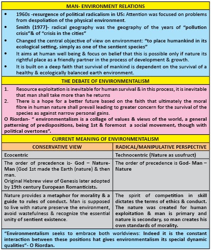
Ecological basis of Environmental Management
- In news:UNESCO’s Environmental Sustainability and Management Policy was published in June 2021.
- Background: what is ecological basis of environment management
- Ecological perspective in geography has been stressed and highlighted by a few ecologists such as C.C. Park .
- The ecological basis approach is based on ecology and environmental values and considers interrelationships among and between living organisms (including humans) and their physical environment.
- The proposed approach builds on the ecological risk assessment (ERA) paradigm, including goal (or problem) identification, values identification (ecological and human) for the environment being managed, and data collection and analysis focused on management decision-making.
- Application of the proposed framework has enabled environmental managers to achieve workable solutions and to avoid or resolve environmental conflicts at both local and regional scales.
- Need for ecological basis of environment management

- Ways to do environment management through ecological basis
- Conservation approach : the environmental (natural) resources may be utilized for the socioeconomic development of human society but simultaneously efforts should also be made to maintain ecological balance, ecosystem stability and environmental quality by adopting suitable pollution-safe and eco-friendly technologies and by making the society answerable to any maladjustment in the natural ecosystem. This is based on the following two pespectives and goals :
- to restrict and minimise adverse effects of human activities during exploitation and utilization of natural resources on environment
- to optimise the productivity of natural environmental ecosystems
- Preservation approach: to environmental management advocates non-interference of man with nature or say with physico-biotic environment and complete adaptation of man to natural environment.
Recently, the scope of preservation approach has been limited to the preservation of ecologically significant plants and animals in specially demarcated and well protected areas where endangered, threatened and potential extinct species of plants and animals are protected such as nature reserve or biosphere reserve, national parks, bird sanctuaries etc.

Festoon (Lava)
- It is a pattern of arcuate, bent, or looped ridges exposed on the surface of a lava flow or on an outcrop of cross-bedded sediment. Also known as Corda, Festoon deposit and Festoon ridge.

- Pahoehoe festoon or festoon ridge (corda) is a subtype of pressure ridge. Ridges on pahoehoe lava flows are regularly spaced 5–50 cm apart, where the ropy surface is dragged by the underlying molten lava into festoon patterns.
- The morphology of festoon-like ridges and flow bands is often characterized lava flow surfaces.
- Sizes of festoon ridges range from small-scale 2–20 cm pahoehoe ropes to meso- and large-scale features 1–100 m high with spacings ranging from 10 m to several hundred meters apart (on rhyolite flows).
- The lava’s surface crust is folded when in a semisolid state during the final still-mobile stages of emplacement as viscosity increases due to cooling.
- Where can we use it:
Geography optional: geomorphology, physical settings of India.
GS: P1
Source:
Climate Vulnerability Index
Why in News - Recently, a report titled “Mapping India’s Climate Vulnerability -A District-level Assessment” has been released by the Council on Energy, Environment and Water (CEEW)
It is a first-of-its-kind Climate Vulnerability Index that assesses the district-wise vulnerability.The Index takes into account certain indicators when assessing the preparedness of a state or district. It considers:
- Exposure(that is whether the district is prone to extreme weather events)
- Sensitivity(the likelihood of an impact on the district by the weather event)
- Adaptive capacity(what the response or coping mechanism of the district is)
Importance of CVI:
- CVI helpsmap critical vulnerabilitiesand plan strategies to enhance resilience and adapt by climate-proofing communities, economies and infrastructure.
- Instead of looking at climate extremes in isolation, the study looks at the combined risk of hydro-met disasters, which is floods, cyclones and droughts, and their impact.
- The vulnerability assessments will be useful for officials, decision makers, funding agencies and experts to have a common understanding on vulnerability and enable them to plan for adaptation.

Source:
Geysers
Map showing the location of world countries with active geyser fields.
A geyser is a rare kind of hot spring that is under pressure and erupts, sending jets of water and steam into the air from a surficial opening. When the underground water which percolates down through the porous rocks is subjected to the heat of the underlying Rock Strata which is in the contact of hot magma it gives rise to geysers.
Ex. Old Faithful is the world's best-known geyser. It is located in Yellowstone National Park (USA).
- The word geyser comes from a spring in Haukadalur, Iceland called Geysir.
- Geysers are temporary geological phenomena. The lifespan of geysers is a few thousand years at most.
- Generally all geyser sites are located close to active volcanic areas.
Conditions Required for Geysers
- hot rocks below
- an ample groundwater source
- a subsurface water reservoir
- fissures to deliver water to the surface

Types of geysers
Fountain geysers: erupt from pools of water in a series of intense violent bursts. Eg: Grand Geyser in Yellowstone National Park (USA). Cone geysers:erupt from cones or mounds of geyserite in steady jets that last from a few seconds to several minutes. Eg: Old Faithful Geyser in Yellowstone National Park (USA) Cold water geysers are similar to hot water geysers, except that carbon dioxide bubbles drive the eruption instead of steam.
Source:
Case study: Man and Biosphere Program (MAB)
The MAB is an international interdisciplinary research program initiated by the UNESCO in 1970 for management of problems arising out of interactions between human activities and the natural environment. This program envisages an ecological approach to the study of interrelationships between man and natural environment. The main objective of MAB is to improve the global relationship between man and natural environment; to predict the future effects of present day human activities and to manage ecological resources on scientific bases. Total 12 biosphere reserves of India which have been recognized internationally under Man and Biosphere Reserve program- recently Panna National Park in Madhya Pradesh has been declared a UNESCO Biosphere Reserve.

- Challenges in ecological basis of environment management
- For ecological evaluations, the problem formulation phase is the most critical because of the hundreds and even thousands of species within any ecosystem, the overall complexity and the great spatial and temporal scales.
For example, single-celled organisms may live for minutes or hours, while some plants and animals live for hundreds of years; some plants reproduce asexually while others reproduce sexually.
- Preservation phase is not practicable because non-interference with natural environment would lead the humanity to complete starvation and even extinction.
- If man has to survive he must derive some thing from the nature, and even the exploitation of minimum resources from the natural environment would cause disequilibrium and ecosystem instability resulting into environmental degradation and pollution.
Ecological basis of environmental management is, in fact, based on ecocentric approach to the management of ecological resources, leading to the attainment of sustainable environment, sustainable development and sustainable society through rational exploitation and optimal utilization of natural resources.
Gambia: The only country to meet its climate targets
Why in news: Gambia is the only country on track to meet commitments under the Paris Agreement, as per Climate Action Tracker which ranks countries by analyzing their NDCs.

Measures taken by the Gambia to meet its climate targets under the Paris agreement:

Where it can be used?
It can be used in topics related to Paper 1 (Climate Change, World Agriculture, Sustainable Development), Paper 2 (Agriculture, Sustainable Growth, decentralized planning) and GS 3 (Agriculture).
Sources:
Places in news - Nuapada
|
Nuapada
|
|
Chikkaballapur
|
|
East Godavari
|
|
Panchmahal
|
|
Haldia
|
|
Zunheboto
|

Share the article
Get Latest Updates on Offers, Event dates, and free Mentorship sessions.


Get in touch with our Expert Academic Counsellors 👋
FAQs
Geography Current Affairs focuses on the contemporary issues, events, and developments in the field of geography. It covers recent geographical phenomena, environmental changes, geopolitical shifts, and related news. This differs from regular geography studies which may focus more on foundational concepts, historical contexts, and theoretical frameworks.
Updates are provided regularly to ensure that subscribers stay informed about the latest developments in geography. Typically, updates are provided on a fortnightly basis, depending on the frequency of significant events and changes in the field.
Absolutely. Geography Current Affairs serves as a valuable resource not only for Geography optional but also for GS papers, especially GS Paper 1 (covering Indian Heritage and Culture, History, and Geography of the World and Society) and GS Paper 3 (covering Technology, Economic Development, Biodiversity, Environment, Security, and Disaster Management). It aids in building a holistic understanding of various topics and strengthens answer-writing skills by incorporating contemporary examples and perspectives.
Geography Current Affairs holds immense importance for UPSC preparation, particularly for aspirants opting for Geography optional. It helps candidates stay updated with the latest developments, geographical phenomena, environmental issues, and geopolitical shifts worldwide, aligning them with the dynamic nature of the subject as tested in the UPSC examinations.