24 Mar to 10 Apr, 2024
FOREST FIRES
Why in news : In South India, most forest covered areas of Andhra Pradesh, Karnataka and Tamil Nadu have seen fire incidents over the second week of March 2024.
Background:
- Forest fires have occurred across the globe at various times in the The sources of these fires have been both natural and anthropogenic.
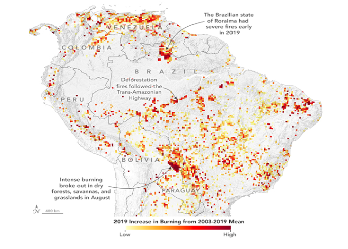
- Forest areas in North America, South and S E Asia, Australia, Africa and Amazonia are prone to the incidence of fires regularly.
- Forest fires occur almost on an annual basis in the deciduous forests of Southern India.
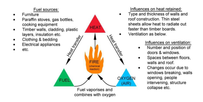
- To get a forest fire starting, three elements must be contemporarily present: a heat source, fuel and oxygen. If one of the three elements is not present (anymore), the combustion reaction cannot start.
Types of Forest fires:
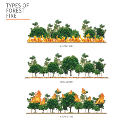
Forest fire broadly classified into three categories:
- Surface fire : Spread with flaming front and burn leaf litter, fallen branches and other fuels located at ground level.
- Ground fire: Burning of organic matter in soil beneath the surface litter and are sustained by glowing combustion.
- Crown fire: Burn through the top layer of foliage on a tree , known as the canopy or crown fires.They are the most intense and difficult to contain
NATURAL CAUSES OF FOREST FIRES
- Volcanic Eruption : Extreme heat of lava may cause vegetation to catch fire and spread. Mauna Ulu eruption in Hawai in 1970s burnt the Naulu forest.
- Lightning : Forest fires frequently happens when lightning bolts continue for an abnormally long time or when they strike a dry material. In 2022, 90% of forest fires in boreal forest of Northern Canada and Alaska triggered by lightning.
- High atmospheric temperatures: High temperature and dryness offer favourable conditions for fire because of lack of moisture. In 2022, fires triggered in Arctic forests due to rising temperatures.
- Dry bamboos : In bamboo areas, forest fires may occur by rubbing together of clumps of dry bamboos. Bamboo bushes in Kakatiya Van Vihar in Telengana caught fire recently.
- El Niño conditions : El Niño , causing extreme dry conditions triggered one of the most severe fire seasons in 2015 in Indonesia.
ANTHROPOGENIC CAUSES
- Shifting cultivation : Shifting agriculture is the dominant driver of forest disturbance in India, especially in North Eastern states.
- To get god grass/ fodder crop : In the upper Himalayan mountain, areas where natural forests still exist , massive fires are set intentionally to get fodder for animals.
- Flush for tendu leaves : In central India, fires are ignited in the forest to increase the production of tendu leaves. Tendu leaves collectors set fires in the summer months to promote a better flush of leaves.
- To conceal illicit felling : Smugglers and poachers in jungles of Odisha are caught many times setting forest fires to hide the stumps of illicit felling. The poachers use forest fires for terrorising wild animals and hunting too.
- Burning farm residue: After harvest, farmers in Haryana , Punjab , UP and Bihar set fire to their agricultural fields. Many times, when these fires are not put out completely, may spread to the adjoining forest areas.
- Protecting crops from wild animals : Villagers residing in or near the forest many times light up the fire in the forest to keep the wild animals away from their crops and cattle.
- Careless travelling : Travellers, picnickers, nomadic grazers, villagers or even forest labourers some time throw un-extinguished cigarettes, bidis, and match sticks in the forest areas. In 2012 , Israeli tourist was arrested for causing forest fire in Chile.

BENEFITS OF FOREST FIRES
- Cleaning the Forest Floor : With the help of fire low-growing underbrush is burned off, the forest floor is cleared of debris, the forest gets exposed to sunshine, and the soil is nourished.
- Promotes biodiversity : The heavy brush is removed from wildlands by fire, making way for fresh grasses, herbs, and regenerated shrubs that provide food and Habitat for various wildlife species.
- Killing Disease : Fire destroys diseases and pests that harm trees while supplying essential nutrients for soil improvement. Rather than fire, Disease and insect infestation claim the lives of more trees each year.
- New Generations : Some trees have bark that can withstand fires and cones that must be heated to open and release seeds for regrowth. Manzanita, chamise, and scrub oak are examples of chaparral plants that also need a lot of heat to germinate their seeds.
- Fire prevents fire : Regularly occurring small wildfires actually prevent bigger, more destructive fires from happening in the future. If a forest doesn’t have a burn for a long time, dead trees and other fuel builds up, causing a much more destructive, out-of-control fire later.
IMPACTS OF FOREST FIRES
- Pollution : The Hyderabad-based NRSC study revealed that concentrations of trace gases and aerosols rose to alarming levels in Uttarakhand p during a massive fire in April-May 2016.
- Deteriorated Water quality : The introduction of fire retardant chemicals into waterbodies can reach levels toxic to aquatic organisms, as seen in Mexico.
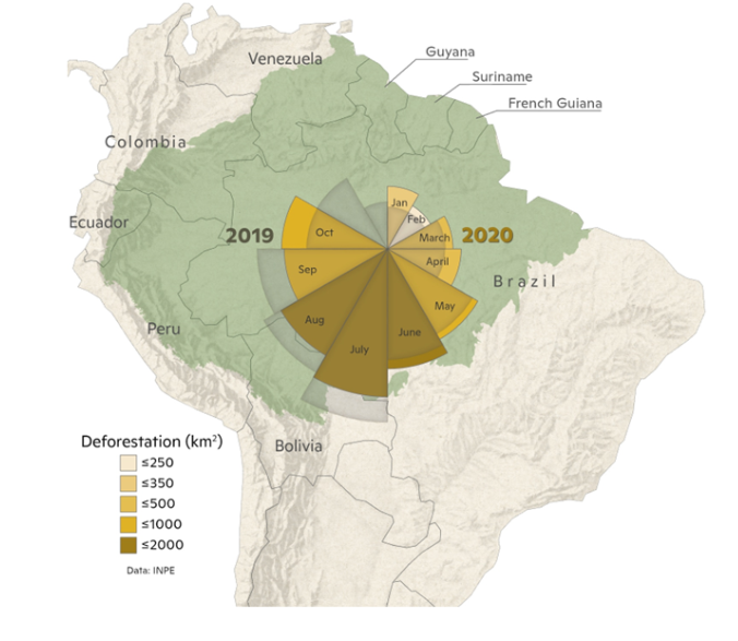
- Health & illnesses : Smoke from fires set in the Amazon region is one of the key causes of respiratory hospitalisations of indigenous people, states in study.
- Loss of resources : The planet continues to experience a massive loss in forest land. The U.S. has lost 29.7 million acres of tree cover from forest fires since 2001.
The U.S. has lost 29.7 million acres of tree cover from forest fires since 2001.
- Disruption of carbon cycle : Forest fire caused the loss of carbon sequestered in forest biomass carbon stock. In the future, due to climate change, a greater number of forest fire events may occur and disturb the carbon cycle.
- Damage to flora and fauna : Forest causes severe threat to flora and fauna. Mammals, reptiles, birds and frogs died in the forest fires every year.
- Soil erosion: In Portugal, as well as in other Mediterranean countries, forest fires has caused soil erosion . Vegetation cover is an important factor in determining runoff and erosion risk.
- Depleting ozone layer : Forest fires in Australia continued from June 2019 to March 2020, and released over 1 million tonnes of smoke that reached to the stratosphere and affected the ozone layer.
- Microclimate change : The changed microclimate caused by the removal of litter and duff, opening of the canopy by killing over storey shrubs and trees and darkening of the soil surface by residual soot and charcoal can increase insulation causing temperature increase.
STATUS OF FOREST FIRES ACROSS THE GLOBE
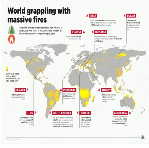
- Most of North and South America, the African plateau, the northern Arabian Peninsula, and the Mediterranean coast of Europe as well as Northern and Eastern Europe have been affected by fires.
- In Asia, fires have been detected on the coasts of India and in Russia's Siberia region as well as in China, Malaysia and Indonesia.
- European countries with Mediterranean coasts such as Italy, Spain, and Greece are also struggling with forest fires.
STATUS OF FOREST FIRES IN INDIA
- According to Forest Survey of India website , there are 337 large Forest fires in the country as of March 14 in this year with 38 in Arunachal Pradesh, 18 in Jharkhand, 16 in Manipur, 15 in Meghalaya, 44 in Mizoram and 147 in Odisha, among others
- The forest fires in Odisha come in the backdrop of the state not receiving any rain since October, which has resulted in forests experiencing dryness and the forest fires spreading.
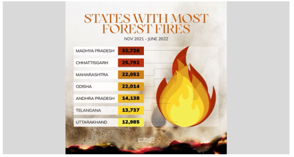
- Andhra Pradesh, Assam, Chhattisgarh, Odisha and Maharashtra are the most prone to high-intensity forest fire events caused by rapid change in climate.
- Mizoram had the highest number of forest fire incidences in the last two decades, with more than 95% of its districts being forest fire hotspots.
- Earlier, forest fires would take place during the summer months, that is between May and June. Now, during spring, between March and May, because of climatic changes.
- The duration that forest fires could take place was two to three months earlier, but it is now nearly six months.
INSTANCES OF FOREST FIRES IN INDIA IN 2023
- The Himachal Pradesh and Nagaland-Manipur border saw prolonged fires in January.
- There was a major wildfire between February and March in the Simlipal National Park in Odisha.
- According to the Indian Express, Southern Chhattisgarh, Central Odisha, Western Maharashtra, and areas of Andhra Pradesh and Telangana are highly prone to forest fires.
- Bandhavgarh Forest Reserve in Madhya Pradesh and sanctuaries in Gujarat also witnessed forest fires.


GOVERNMENT INITIATIVES TO PREVENT FOREST FIRES IN INDIA
- The National Forest Policy of Government of India, 1952 states that the claims of the communities residing near forests should not override national interest. This was done in order to protect the forests from incessant exploitation, thus cultivation and other related activities were allowed only in unclassified forest land.
- National Mission for Green India, introduced in 2014 aims at protecting and enhancing the forest cover of the country by involving the local communities in planning and decision-making of the same.
- Compensatory Afforestation Fund Management and Planning Authority (CAMPA) was introduced in 2014, to check the usage of unspent money raised by the central and the state governments.
- The Central Government is also providing assistance to the State Governments under the centrally sponsored scheme – the National Afforestation Program (NAP) “for regeneration of degraded forests and adjoining areas through people’s participation.
- Since 2004, the Forest Survey of India(FSI) developed a Fire Alert System. The system will monitor forest fires in real-time. In 2019, an advanced version of the system was also launched.
- Using the MODIS sensors(Moderate Resolution Imaging Spectroradiometer) Real-time fire information of fire hotspots is collected and sent to FSI. This is then forwarded by email to state, district, circle, division, range and beat levels. People in the locality will also receive SMS alerts.
COUNCIL ON ENERGY , ENVIRONMENT AND WATER RECOMMENDATIONS FOR MANAGING FOREST FIRES
- Recognise forest fires as a disaster type and integrate them into national, sub-national and local disaster management plans.
- Develop a forest fire- alert system, which does not segregate forest fires from other fires such as waste burning and crop burning.
- Enhance adaptive capacity with training on high technology-focused equipment (like drones) and nature-based modules such as creating effective forest fire lines.
- Provide clean air shelters in public buildings or government schools to create clean air shelters for communities worst impacted by fires and smoke from forest fires.
WAY FORWARD :
- Revision of Indian Forest Act with some relevant section needs to be revised to give due importance to legal protection against man-made forest fire.
- Designing and installing a network of fire forecasting at National and State levels in collaboration with the Meteorological Department.
- International coordination along with organising seminars, training programs, conferences, and study tours in different countries leading in Forest Fire Management, e.g., U.S.A., Australia, U.K., Spain, France, etc.
- Need to work on a new system of issuing pre-fire alerts to prevent such incidents.
- Designing syllabus for planning, management, ground level firefighting courses in Forestry Institutions.
- Promotion of people’s participation through involvement of NGOs, Voluntary Organisations, Village Forest Committees (VFCs)
- Creation of Forest Self-Help Groups (FSHGs) or local Forest Special Purpose Vehicles (FSPV) — with an industrial linkage to the removal of dry needles with the help of villagers.
- Set up National Institute of Forest Fire Management with satellite centers in different parts of India with an objective to bring the latest forest fire fighting technologies to India through proper research, training of personnel etc.
CONCLUSION :
Forest fires have been a local issue with global impact, which may happen more frequently than the recent past due to impact of rising temperature and global warming. As populations grow with expansion of industrial development into forested areas and climate change alters fire regimes, the risk to communities and infrastructure will likely increase. Mischievous fires originated from villages near the forest areas are the major causal factors for fire incidences. Therefore, sensitisation of people and their social awakening through various meeting with villagers/ settlers and awareness campaigns about the negative consequences of forest fires on their health, environment and degradation of natural resources can be very effective to prevent forest fires.
Where to use ?
Paper I ( Geography Optional ) : Environmental Geography
Paper II ( Geography Optional ) : Forest fires and Climate Change
HEAT WAVES IN COASTAL KERALA
Why in news : Recently, the Indian Meteorological Department (IMD) issued an alert warning of heatwave for 40°C in Thrissur and 39°C in Kollam and Palakkad districts of Kerala.
About :
- Heatwaves, characterized by extended stretches of unusually high temperatures, can lead to negative effects on public health, environmental balance, and economic stability.
- Due to its tropical location, India is especially susceptible to the impacts of heatwaves.
IMD Criteria for Declaring Heat Wave in India:
- A heat wave is declared if a weather station's maximum temperature hits at least 40°C in plains areas or at least 30°C in mountainous regions.
- For coastal areas, the threshold for a heat wave is a maximum temperature of 37°C or higher.
- When the usual maximum temperature of a location is 40°C or lower, a heat wave condition is identified by a rise of 5°C to 6°C above the normal temperature.
Heat Dome
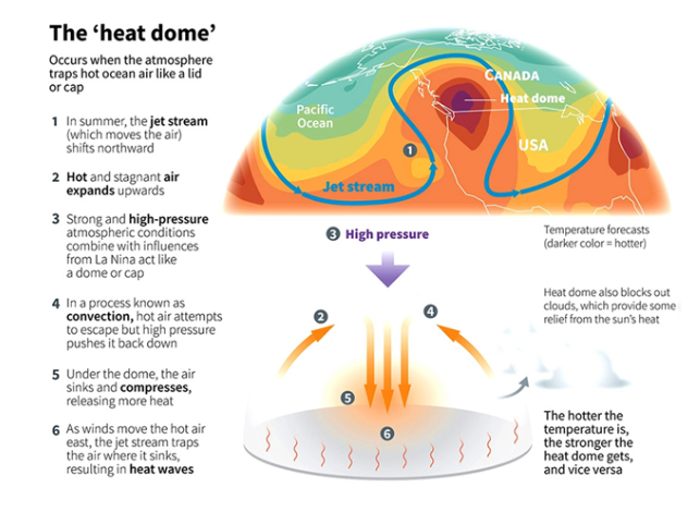
- A heat dome happens when the atmosphere captures warm ocean air underneath it, acting as a cap or lid.
- The National Oceanic and Atmospheric Administration (NOAA) in the United States explains that a heat dome forms due to the merging of intense high-pressure atmospheric conditions with specific weather patterns, such as La Niña.
- During La Niña years, such as 2021, the occurrence of heat domes is more frequent because of the cooler waters in the eastern Pacific and warmer waters in the western Pacific, leading to widespread heat.
- Regarding the duration of heat domes, NOAA notes that they usually persist for about a week. After this period, the dome typically becomes too unstable to maintain its structure, collapsing and allowing the previously confined air to disperse, thereby bringing an end to the intense heat.
Causes of Formation of Heat Dome
- Change in Ocean Temperature: The process starts with a significant shift (or gradient) in sea temperatures. This temperature gradient prompts a process called convection, where warm air, heated by the sea surface, begins to ascend above it. As the prevailing winds push this heated air eastward, alterations in the jet stream's path confine the air, directing it towards the land. Once there, the air descends, causing heatwaves.
- Change in Atmospheric Pressure: The onset of heatwaves is marked by the arrival of a high-pressure system in the atmosphere, which drives warm air down towards the earth's surface. This phenomenon is intensified by the heat emanating from the sea, creating a feedback loop that amplifies the effect. The downward pressure of the high-pressure system causes it to expand upwards, redirecting other weather patterns. It also reduces wind and cloud formation, intensifying the heat. Consequently, a heatwave tends to linger over a region for extended periods.
- Climate Change: Increased global temperatures result in more intense heat conditions. While heatwaves are common terrestrial events, global warming has made them hotter, longer, and more frequent. The consensus among climate scientists is that today's heatwaves are more intense due to climate change, largely attributed to human activities.
Impact of Heat Waves and Heat Domes:
- Risk of Wildfires: Heat domes contribute to the ignition of wildfires, annually devastating extensive land areas in countries such as the USA.
- Prevents Cloud Formation: This phenomenon also hinders the formation of clouds, enabling increased solar radiation to reach the earth's surface.
- Heat Strokes and Sudden Fatalities: Extremely high temperatures and humidity levels significantly raise the chances of heat strokes or exhaustion. Elderly individuals and those with chronic conditions like heart, respiratory diseases, and diabetes are particularly vulnerable to heat strokes, as aging impairs the body’s heat regulation capabilities. Homes lacking air conditioning may see temperatures rise to life-threatening levels, potentially causing fatalities.
- Effect on Vegetation: The retention of heat can harm crops, desiccate plants, and lead to drought conditions.
- Increased Energy Demands: The intense heat leads to a spike in the demand for energy, particularly for electricity, which in turn can drive up prices.
- Power Related Issues: Heatwaves frequently result in deadly outcomes. The ability to avoid heat-related catastrophes relies on the electrical grid's resilience, which is at risk of failure if the demand for electricity, primarily from air conditioning, surpasses the supply. This poses a dual threat of infrastructure collapse and adverse health effects.
Steps for Avoiding Heat Waves
Individual Level:
- Maintaining Hydration: Keeping yourself indoors, resting in an environment with low humidity (around 10%), and continuously drinking water to enable sweat production can prevent overheating even in temperatures up to 46℃. Nonetheless, it's important to recognize the limits of human endurance to heat, especially at high wet-bulb temperatures, where heat and humidity combine to create conditions unbearable for humans.
- Adjusting Exercise Schedules: Opting for workouts in the cooler early morning hours or in air-conditioned spaces. In cases of extreme heat, it might be wise to skip exercise sessions altogether.
Public Level:
- Establishing Cooling Centers: Setting up emergency cooling centers helps those without access to air conditioning at home to find relief from the heat. Spaces with air conditioning are invaluable for those affected by heat domes.
- Utilizing Portable Cooling Devices: Employing portable air conditioners, fans, and even ice can provide temporary relief from high temperatures.
Long Term Solutions:
- Promoting Tree Planting: The planting of trees not only offers essential shade but also lowers neighborhood temperatures through the evaporation of water from their leaves. Additionally, tree foliage can cleanse the air of pollutants, which is crucial since heat waves tend to intensify urban smog, posing additional risks to individuals with existing health conditions.
- Switching to Lighter Roofing: The intense heat in cities, in comparison to rural settings, is largely due to dark-colored roofs, roads, and parking spaces that absorb heat. Substituting these surfaces with lighter, reflective materials can make urban environments cooler.
- Heat Wave Blackout Preparedness: The risk of a major blackout during a heatwave could disrupt power for millions, affecting their ability to use fans or air conditioning. Enhancing the electrical grid with smarter technology and predictive tools could allow utility companies to better anticipate and manage the demands of a heat wave, including adjusting building temperatures before the day's heat reaches its peak.
Source :
Where to use :
Paper I ( Geography optional ) : Climatology
Paper II ( Geography Optional ) : Heat Waves , Global warming
CONTRASTING PATTERNS OF HEATING AND COOLING OBSERVED IN NORTH ATLANTIC OCEAN
Why in news : The contrasting pattern of heating and cooling in the North Atlantic Ocean is linked to the slowdown of the Atlantic Meridional Overturning Circulation
About :
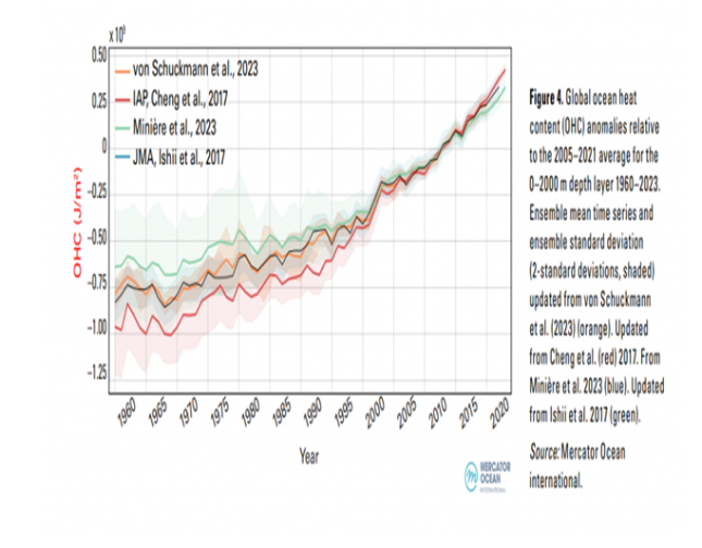
- As the global climate continues to change, the oceans play a pivotal role in the Earth's energy balance. In 2023, the heat content of the world's oceans not only reached a new record high but also exhibited a complex pattern of both warming and cooling regions.
Record Ocean Heat Content in 2023
- The WMO's State of the Global Climate 2023 report underscores a significant milestone in the ocean's heat content. Last year, the oceans stored energy exceeded the previous records, marking a concerning trend in global warming. Specifically, the ocean heat content in 2023 surpassed the 2022 , a stark indicator of the ongoing accumulation of thermal energy in the marine environment.
- Unprecedented Sea-Surface Temperatures: Alongside rising ocean heat content, global average sea-surface temperatures (SST) also reached record highs in 2023.
- Exceptional warming was observed across vast stretches of the oceans, from the eastern North Atlantic and the Gulf of Mexico to the North Pacific and the Southern Ocean.
- The monthly records for July, August, and September were shattered by margins of about 0.21-0.27°C. This trend has continued into 2024, with January witnessing an average global SST of 20.97°C over the 60°S-60°N range, the highest ever recorded for that month.
- The Cooling Anomaly- The North Atlantic Cold Blob: Contrasting the general trend of ocean warming, a relatively small region in the subpolar North Atlantic Ocean has been experiencing cooling. This area, extending from the surface down to depths of over 800 meters, has seen a decrease in sea surface temperatures by approximately -17.3 degrees Celsius over the past century. This phenomenon, often referred to as the North Atlantic cold blob, is thought to be driven by complex interactions between the ocean and atmosphere, including the slowdown of the Atlantic Meridional Overturning Circulation (AMOC).
- The AMOC and Climate Implications : The AMOC, a crucial system of ocean currents that redistributes heat across the Atlantic, is showing signs of instability. Recent research published in 2024 indicates that the AMOC is approaching a tipping point, with potential future collapse posing severe threats to the climate of the North Atlantic region. The AMOC's slowdown is linked not only to the cooling observed in the subpolar North Atlantic but also to broader climatic impacts, including shifts in weather patterns and sea level rise.
Conclusion
The record ocean heat content and SSTs of 2023, juxtaposed with the cooling in parts of the North Atlantic, highlight the complexity of climate change and the critical role of the oceans. With approximately 90% of the excess energy in the Earth system stored in the oceans, unraveling these dynamics is crucial for predicting and mitigating future climate impacts.
Source
Where to use:
Paper 1 ( Geography Optional ) : Climatology
Paper 1 ( General Studies ) : Ocean currents
Adolescent Birth Rate
Adolescent Birth Rate: The adolescent birth rate (ABR) is the number of births per 1,000 women aged 10–14 or 15–19, calculated annually. It is a demographic and socio-economic statistic that measures the risk of childbearing among females in that age group. The ABR is also known as the age-specific fertility rate.
Bambi Bucket
Bambi Bucket : The Bambi Bucket, also called a helicopter bucket or a helibucket, is a specialised container that is suspended by cable under a chopper, and which can be filled by lowering into a river or pond before being flown above a fire and discharged aerially by opening a valve at the bottom of the bucket. The Bambi Bucket is especially helpful in fighting wildfires that are difficult or impossible to reach from the ground. Around the world, helicopters are frequently commissioned to fight forest fires.
Astronomical Cycles
Astronomical Cycles : Astronomical cycles refer to periodic variations in the Earth's orbit and orientation towards the Sun that impact the amount of solar radiation received by our planet over long periods. These cycles are caused by the gravitational forces between the Earth, Sun, and other planets in the solar system.These cycles were first theorised by Serbian scientist Milutin Milankovitch in the 1920s to explain the cyclical patterns of ice ages on Earth also called Milankovitch cycles, or Milankovitch oscillations.
Marine Heatwaves
Marine Heatwaves : A marine heat wave is an extreme weather event which occurs when the surface temperature of a particular region of the sea rises to 3 or 4 degree Celsius above the average temperature for at least five days. MHWs can last for weeks, months or even years, according to the US government’s agency National Oceanic and Atmospheric Administration (NOAA).
Atlantic Meridional Overturning Circulation
Atlantic Meridional Overturning Circulation : The Atlantic Meridional Overturning Circulation (AMOC) is a major ocean current system that transports warm surface waters from the tropics toward the northern Atlantic and colder deep waters that are part of the thermohaline circulation, southward. One of the main ways the ocean circulates heat, salt, carbon, and nutrients throughout the world’s oceans is through overturning circulation.
BOMB CYCLONE IN CANADA AND USA
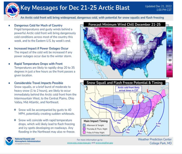
A winter storm, unofficially named "Storm Elliott", wreaked havoc across Canada and the USA in the year 2022, eventually transforming into a "bomb cyclone".
- Temperatures plummeted by 30–50 degrees Fahrenheit (around 17–28 degrees Celsius) nationwide, leading to blizzard conditions characterised by heavy snowfall and winds gusting over 50 miles per hour.
- The cold was so extreme in Florida that local authorities issued a "falling iguana alert" as frozen iguanas were dropping from the trees.
- 1.7 million were left without power during the Christmas period, and over 60% of the US population was living under a winter weather alert.
- The severe weather caused widespread chaos on the roads, resulting in temporary closures.
- Numerous crashes occurred throughout the country. A major crash involving 85 cars took place in Illinois. Approximately 20,000 domestic flights were cancelled, causing significant travel disruptions for thousands of holiday travellers trying to return home for Christmas.
Source : https://curriculum-press.co.uk/blog/storm-elliot-once-in-a-generation
Where to use :
Paper I ( Geography Optional ) : Cyclones
Paper 1 ( General Studies ) : Cyclones and their effects
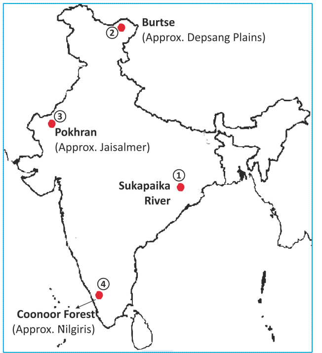
Places in News - 10 April 2024
1. Sukapaika river :
Why in news : Odisha government to spend Rs 50 crore to rejuvenate Sukapaika river
- Sukapaika is one of the several distributaries of the mighty Mahanadi river in Odisha.
- It branches away from the Mahanadi at Ayatpur village in Cuttack district and flows for about 40 kilometres (km) before rejoining its parent river at Tarapur in the same district.
- Sukapaika river is an important system of the Mahanadi to control floodwater and maintain the flow in the river as well as the Bay of Bengal.
2. Burtse
Why in news : Geologist finds marine fossils at icy heights in Burtse
- Burtsa, alternately spelled as Burtse, is a historic halting spot on the caravan route at the southern end of the Depsang Plains, where the Depsang Nala joins the Burtsa Nala.
- It currently serves as a military camp of the Indo-Tibetan Border Police (ITBP) and the Indian Army on the Darbuk-Shyok-DBO road, about 15 kilometres on the India's side of the LAC.
- North of Burtsa is Qizil Langar, also called Qazi Langar.
- Approx : Depsang Plains
3. Pokhran
Why in news : A Tri-Services Live Fire and Manoeuvre Exercise named "Bharat Shakti'' is being conducted in Pokhran, Rajasthan
- Pokhran is a town and a municipality located 112 km east of Jaisalmer city in the Jaisalmer district of the Indian state of Rajasthan.
- It is situated in the Thar Desert region. It lies on Jaisalmer to Jodhpur railway line.
- It receives a little rain in the monsoon months July to September. Pokhran has extreme climate. It has extremely hot and dry summers from April to June though monsoon months are also very hot. The temperature in summer can reach 46°C during the day. The night temperature in summer is more than 30°C, Pokhran has very cold winters with temperature dropping to 1°C.
- Approx : Jaisalmer
4. Coonoor Forest
Why in news : Forest fires have been raging in the Coonoor forest range in the Nilgiris in Tamil Nadu.
- Coonoor is a Taluk and a municipality of the Nilgiris district in the Indian State of Tamil Nadu.
- Droog Fort is located a distance of 13 km from Coonoor and was once used by Tipu Sultan in the 18th century.
- Law's Falls is a waterfall located 5 km from Coonoor, on the way to Mettupalayam.
- Approx : Nilgiris
5. Begusarai
Why in news : According to the 2023 World Air Quality Report by IQAir, Begusarai in Bihar is the world's most polluted city.
- Begusarai is the industrial and financial capital of Bihar and the administrative headquarters of the Begusarai district, which is one of the 38 districts of the Indian state of Bihar.
- The district lies on the northern bank of the river Ganges in the Mithila region of India.
- Begusarai lies in the middle of the mid-Ganga plain and generally has low-lying terrain with a south to south-easterly slope. Begusarai is basically divided into three floodplains: the Ganga floodplain, Burhi Gandak floodplain, Kareha-Bagmati floodplain
- Approx . Munger
Fortnightly KOSMOS MCQs Practice
Q1. With reference to Corbett Tiger Reserve, consider the following statements:
- It is located in Uttarakhand
- It is the first National Park of India .
- The reserve is traversed by Dhauliganga river
How many of the above statements are correct?
- Only one
- Only two
- All three
- None
Q2. Consider the following statements regarding the Democratic Republic of Congo (DRC):
- The Democratic Republic of the Congo ranks as the second-largest country in Africa and the eleventh largest globally.
- Its capital, Kinshasa, is uniquely located on the Congo River, which is distinguished as the sole river in Africa to cross the equator twice
Which of the statements given above is/are correct?
- 1 Only
- 2 Only
- Both 1 and 2
- Neither 1 nor 2
Q3. Consider the following statements regarding the Intergovernmental Panel on Climate Change (IPCC):
- It was established in 1988 by the World Meteorological Organization (WMO) and the International Union for Conservation of Nature (IUCN).
- The assessments from the IPCC offer a scientific foundation for governments at various levels to create policies related to climate.
- The IPCC has produced eleven Assessment Reports since 1988.
How many of the above statements are correct?
- Only one
- Only two
- All three
- None
Q4. Consider the following statements regarding Astronomical cycles:
- It describes the regular changes in Earth's orbit and its angle relative to the Sun, which influence the solar energy our planet receives over extended time frames.
- The gravitational interactions among Earth, the Sun, and other planetary bodies in the solar system induce these cycles.
Which of the statements given above is/are correct?
- 1 Only
- 2 Only
- Both 1 and 2
- Neither 1 nor 2
Q5. With reference to the forest fires, consider the following statements:
- Compared to evergreen, semi-evergreen, and montane temperate forests, dry deciduous forests are more prone to intense fires.
- During the period from November to June, the forests in Northeast India, Odisha, Maharashtra, Jharkhand, Chhattisgarh, and Uttarakhand face the highest risk of wildfires.
Which of the statements given above is/are not correct?
- 1 Only
- 2 Only
- Both 1 and 2
- Neither 1 nor 2
Q6. World Air Quality Report 2023 is released by which of the following:
- Intergovernmental Panel on Climate Change
- Swiss organisation IQAir
- Global Footprint Network
- Greenpeace
Q7. Consider the following statements regarding Snakes:
Statement-I: Specific species of snakes, including cobras, kraits, and Black mambas, are utilized for their medicinal and intoxicating effects.
Statement-II: The venom of a snake comprises a sophisticated blend of enzymes, peptides, and proteins with low molecular weight, each possessing distinct chemical and biological functions.
Which one of the following is correct in respect of the above statements?
- Both Statement-I and Statement-II are correct and Statement-II is the correct explanation for Statement I
- Both Statement-I and Statement-II are correct and Statement-II is not the correct explanation for Statement-I
- Statement-I is correct but Statement-II is incorrect
- Statement-I is incorrect but Statement-II is correct
Q8. With reference to the New Electric Vehicle Policy, consider the following statements:
- The policy reduces the customs duty rate to 35% for electric vehicles (EVs) priced at USD 35,000 or higher for a period of 5 years.
- It limits the annual import of EVs to 10,000 units.
- As an incentive to boost domestic production, companies are required to establish operational facilities within a timeframe of 5 years.
How many of the above statements are correct?
- Only one
- Only two
- All three
- None
Q9. Consider the following statements about ‘State of the Global Climate 2023’ report:
- It is published by The World Meteorological Organization (WMO) .
- In 2023, the global average sea-surface temperatures (SST) reached an unprecedented high, surpassing previous records by substantial margins in several months.
- The oceans have become more acidic as a result of absorbing more carbon dioxide.
How many of the above statements are correct?
- Only one
- Only two
- All three
- None
Q10. Consider the following statements about Palm Oil :
- India ranks as one of the world's largest importers of edible oil, sourcing approximately 96% of its palm oil needs from abroad.
- Indonesia and Malaysia stand as the leading nations in global palm oil production.
Which of the statements given above is/are correct?
- 1 Only
- 2 Only
- Both 1 and 2
- Neither 1 nor 2
Q11. Consider the following statements :
Statement I: Although most parts of the world's oceans are getting warmer, some smaller areas, like the subpolar North Atlantic Ocean, are undergoing a cooling phase.
Statement II: The reduction in the speed of the Atlantic Meridional Overturning Circulation (AMOC), which is a network of ocean currents, leads to the ocean's temperature dropping.
Which one of the following is correct in respect of the above statements?
- Both Statement-I and Statement-II are correct and Statement-II is the correct explanation for Statement I
- Both Statement-I and Statement-II are correct and Statement-II is not the correct explanation for Statement-I
- Statement-I is correct but Statement-II is incorrect
- Statement-I is incorrect but Statement-II is correct
Q12. Consider the following statements regarding ‘Global Methane Pledge’:
- This initiative was inaugurated during the UNFCCC COP26 in 2021 to stimulate efforts towards diminishing methane emissions.
- It sets a target to decrease global methane emissions by 50% from the levels recorded in 2020 by the year 2050.
Which of the statements given above is/are not correct?
- Only 1
- Only 2
- Both 1 and 2
- Neither 1 nor 2
Q13. “ Global E-waste Monitor, 2024” has been released by which of the following?
- Greenpeace International
- International Union for Conservation of Nature
- The United Nations Institute for Training and Research
- The United Nations Environment Programme
Q14. Consider the following statements regarding the Captive Elephant (Transfer or Transport) Rules, 2024:
- An authorized veterinarian must confirm the appropriateness of both existing and future habitats.
- The Chief Wildlife Warden holds the power to sanction or deny the relocation of elephants as per their judgement.
Which of the above statements is/are correct?
- Only 1
- Only 2
- Both 1 and 2
- Neither 1 nor 2
Q15. The Black Sea is bordered by which of the following?
- Ukraine
- Russia
- Georgia
- Turkey
- Bulgaria
Select the correct answer using the code given below:
- 1 and 2 only
- 2, 3, and 4 only
- 1, 3, 4 and 5 only
- 1, 2, 3, 4 and 5
Share the article
Edukemy’s Current Affairs Quiz is published with multiple choice questions for UPSC exams
MCQ
Get Latest Updates on Offers, Event dates, and free Mentorship sessions.

Get in touch with our Expert Academic Counsellors 👋
FAQs
Geography Current Affairs focuses on the contemporary issues, events, and developments in the field of geography. It covers recent geographical phenomena, environmental changes, geopolitical shifts, and related news. This differs from regular geography studies which may focus more on foundational concepts, historical contexts, and theoretical frameworks.
Updates are provided regularly to ensure that subscribers stay informed about the latest developments in geography. Typically, updates are provided on a fortnightly basis, depending on the frequency of significant events and changes in the field.
Absolutely. Geography Current Affairs serves as a valuable resource not only for Geography optional but also for GS papers, especially GS Paper 1 (covering Indian Heritage and Culture, History, and Geography of the World and Society) and GS Paper 3 (covering Technology, Economic Development, Biodiversity, Environment, Security, and Disaster Management). It aids in building a holistic understanding of various topics and strengthens answer-writing skills by incorporating contemporary examples and perspectives.
Geography Current Affairs holds immense importance for UPSC preparation, particularly for aspirants opting for Geography optional. It helps candidates stay updated with the latest developments, geographical phenomena, environmental issues, and geopolitical shifts worldwide, aligning them with the dynamic nature of the subject as tested in the UPSC examinations.

