
24 Sep to 10 Oct, 2026
NATIONAL COASTAL MISSION 2.0
Why in news : Recently, the Union Environment Minister launched the implementation Guidelines for National Coastal Mission 2.0 (NCM 2.0) in New Delhi.
About :
India’s coasts are centres of economic activity, ecological diversity and human settlement. Yet coastal development often weakens the natural systems on which it depends. Ports can disrupt sediment movement, tourism can overwhelm local services, and wetland reclamation can increase flood vulnerability.
1. What is National Coastal Mission 2.0?
NCM 2.0 is a Central Sector Scheme under the Ministry of Environment, Forest and Climate Change, with an approved outlay of ₹767 crore and implementation extending to 2030–31. It covers nine coastal states and four Union Territories.
The mission seeks to strengthen coastal resilience through ecosystem restoration, pollution management, scientific planning, sustainable tourism and institutional coordination. It promotes cooperation between the Union government, coastal states, research institutions and other stakeholders.
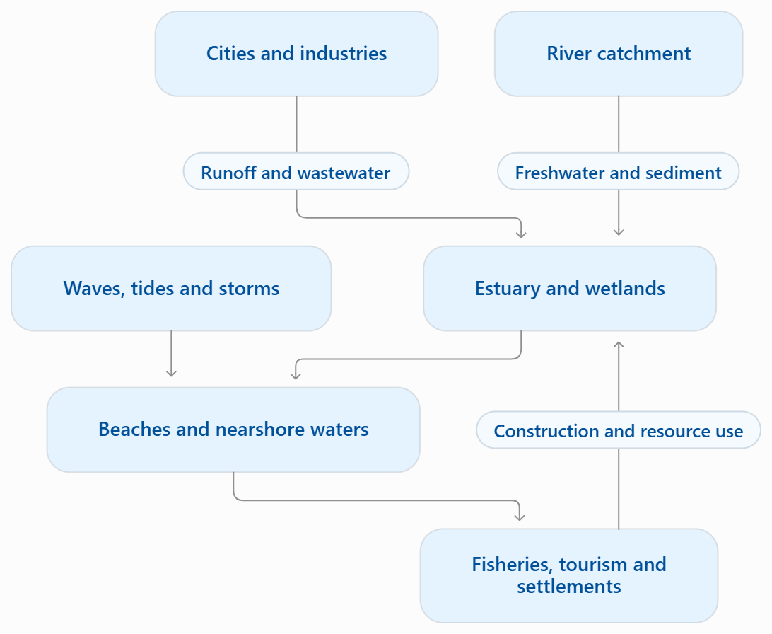
Its geographical importance lies in treating the coast as a connected region. Rivers, estuaries, beaches, nearshore waters and coastal settlements influence one another. Effective management must therefore extend beyond individual beaches or isolated conservation projects.
2. Objectives
The official implementation guidelines identify the following broad objectives:
- Strengthen climate resilience: Support adaptation and mitigation measures for coastal ecosystems and communities.
- Conserve fragile ecosystems: Protect mangroves, coral reefs, brackish-water wetlands and other coastal habitats.
- Improve spatial planning: Develop Integrated Coastal Zone Management Plans and Coastal Marine Spatial Plans.
- Support resilient livelihoods: Encourage diversified income opportunities for coastal communities.
- Control pollution: Prevent and reduce pollution in coastal and territorial marine waters.
- Build institutional capacity: Improve research, training, awareness and stakeholder participation.
- Promote a sustainable blue economy: Link productive use of coastal resources with ecological protection and inclusive development.
The crucial policy connection is that healthy ecosystems support productive economies, while sound planning prevents development from undermining that foundation.
3. What can India gain from the mission?
- Lower disaster vulnerability
- Coastal ecosystems can complement engineered protection. Mangroves attenuate waves under suitable conditions, dunes store sediment, and wetlands provide space for water.
- For example, conservation in the Sundarbans and Odisha’s mangrove regions can strengthen natural buffers while supporting biodiversity. However, ecological protection must accompany shelters, warnings and evacuation arrangements.
- The geographical principle is risk reduction through multiple measures: no single intervention can address storm surge, heavy rainfall, erosion and salinity simultaneously.
- More effective erosion management
- NCCR’s assessment for 1990–2018 identified approximately 33.6% of the assessed shoreline as eroding, 26.9% as accreting and 39.6% as stable. These figures describe historical shoreline behaviour, not annual erosion rates.
- NCM 2.0 can improve decisions by focusing on sediment budgets—the balance between material entering and leaving a coastal stretch.
- For example, where harbour structures interrupt sand movement, further construction may aggravate erosion. Understanding sediment pathways helps identify whether nourishment, structural modification or development setbacks would be appropriate.
- Stronger fisheries and coastal livelihoods
- Mangroves, seagrass and estuaries support feeding, breeding and nursery habitats. Their restoration can strengthen the ecological foundations of fisheries.
- Chilika Lagoon illustrates this relationship. Following hydrological restoration, including a new sea mouth opened in September 2000, recorded fish landings increased from approximately 4,889 tonnes in 2000–01 to 11,989 tonnes in 2001–02. These historical figures demonstrate the potential livelihood benefits of restoring ecological connections.
- Complementary investment in local processing, storage and safer landing facilities can help communities retain more value from existing catches.
- Biodiversity protection with climate benefits
- India’s mangrove cover was assessed at 4,991.68 square kilometres in ISFR 2023. Protecting these ecosystems can combine biodiversity conservation, carbon storage and coastal adaptation.
- The benefits are wider than carbon alone. Gulf of Mannar ecosystems, for example, demonstrate the importance of conserving interconnected marine habitats.
- This supports the geographical idea of ecosystem services: natural systems generate benefits that conventional project accounts often overlook. Their destruction can therefore create substantial economic costs even when immediate commercial returns appear attractive.
- Better coastal development and fewer conflicts
- Ports, fishing routes, tourism, conservation and energy projects frequently compete for the same coastal space.
- Marine Spatial Planning can identify compatible uses and reduce conflicts before investments become difficult to alter. UNESCO emphasises participatory, ecosystem-based planning for this purpose.
- For instance, a tourism plan should protect fishing access and sensitive habitats alongside visitor facilities. McHarg’s overlay method can combine hazard, habitat and land-use maps to identify suitable development locations.
- More sustainable tourism
- Tourism can generate employment, but visitor growth must remain compatible with local water, sanitation and waste-management capacity.
- For Lakshadweep, limited land and freshwater make carrying capacity particularly important. A resort’s economic viability cannot be separated from its effects on island services and ecosystems.
- NCM 2.0 can encourage tourism that retains local benefits while maintaining environmental quality. The relevant measure is not simply increasing arrivals, but improving income without degrading the destination.
- More balanced regional development
- Coastal investment often concentrates around established cities and ports. Myrdal’s cumulative causation explains how these centres attract further capital, while nearby communities may receive fewer benefits.
- The mission can help address this imbalance through community enterprises, restoration employment and locally appropriate infrastructure.
- For example, supporting fish processing and marketing can strengthen links between major markets and smaller coastal settlements. Development becomes more inclusive when local producers participate in value chains rather than merely supplying resources.
4. What are the major challenges and limitations?
A. Limited finance relative to coastal needs
- The ₹767 crore outlay must support several priorities across a geographically extensive coastline. It cannot independently resolve all erosion, pollution, habitat and infrastructure problems.
- Moreover, the guidelines include prior commitments and administrative functions within the overall budget. The entire allocation should therefore not be interpreted as fresh ecosystem-restoration expenditure.
- Its effectiveness will depend on whether it influences larger investments by other agencies.
B. Fragmented institutional responsibilities
- Forests, fisheries, ports, tourism, urban development and disaster management operate through different departments.
- A wetland may receive restoration funding while nearby infrastructure interrupts its tidal exchange. Such contradictions reflect a mismatch between ecological systems and administrative boundaries.
- Coordination must influence approvals, budgets and enforcement. Meetings alone cannot ensure integrated management.
C. Uniform solutions may ignore regional differences
- A measure appropriate for a muddy delta may fail on a sandy beach or coral island.
- The Sundarbans, Kerala and Lakshadweep differ in geomorphology, settlement density, freshwater availability and ecological processes. Uniform plantation targets or seawall designs would overlook these differences.
- Hartshorne’s areal differentiation therefore provides a central warning: national policy requires region-specific implementation.
D. Protection can transfer or create risk
- Hard structures may defend selected assets while altering sediment movement elsewhere. They can also encourage further construction behind them, increasing future exposure.
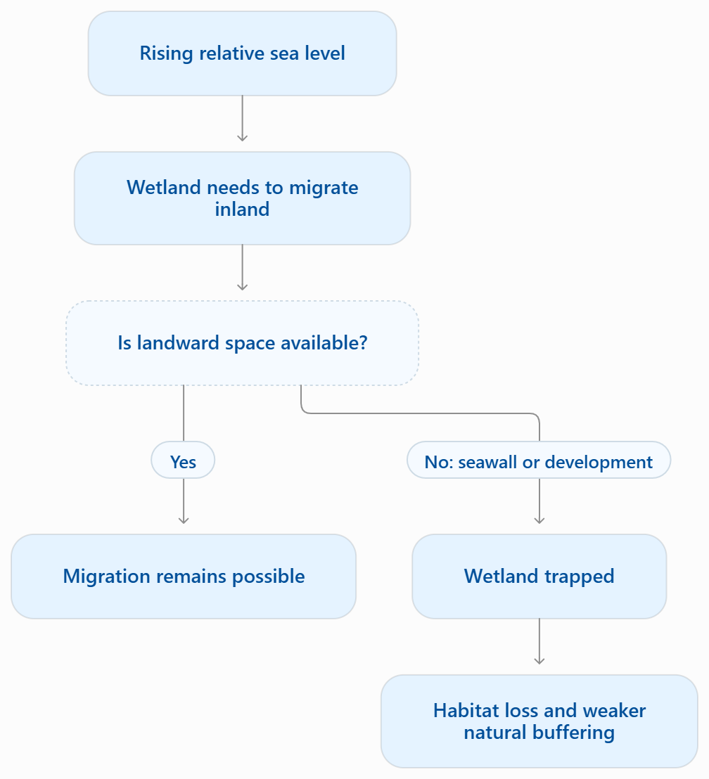
- Seawalls may prevent wetlands from migrating inland as sea level rises, producing coastal squeeze. IPCC assessments identify habitat loss and long-term dependence on protection among potential adaptation problems.
- Protection should therefore be evaluated through its wider and long-term consequences.
E. Community participation may remain superficial
- Fishing communities depend on landing sites, access routes, net-drying spaces and customary resource use. These may be poorly recorded in official maps.
- Conservation or tourism projects can restrict such access without adequate livelihood alternatives. Political ecology highlights this distributional issue: who gains from development, and who absorbs its costs?
- Participation must shape decisions before project designs become fixed.
F. Climate uncertainty and weak monitoring
- Future risks depend on sea-level rise, subsidence, storms and development patterns. Historical averages alone may underestimate emerging vulnerability.
- Project evaluation presents another difficulty: counting plantations, workshops or completed structures is easier than measuring ecological recovery.
- Without reliable baselines and repeated monitoring, apparent success may reflect favourable seasonal conditions rather than effective intervention.
5. Which government initiatives provide an existing foundation?
NCM 2.0 can build on several established measures:
|
Initiative |
Contribution to coastal management |
|
CRZ Notification, 2019 and Coastal Zone Management Plans |
Provide a regulatory and spatial framework for coastal conservation, development and livelihood protection. |
|
MISHTI |
Promotes mangrove restoration through convergence; its stated objective covers approximately 540 km². |
|
Integrated Coastal Zone Management initiatives |
Support coordinated planning across coastal activities and ecosystems. |
|
BEAMS programme |
Promotes beach pollution control, environmental education, safety and management towards Blue Flag standards. |
|
INCOIS services and SAMUDRA application |
Provide ocean forecasts, marine advisories and hazard information for coastal users. |
These initiatives offer complementary functions: regulation, restoration, planning, beach management and preparedness. NCM 2.0 should connect their implementation rather than reproduce separate administrative structures.
6. What should be the way forward?
- First, plan through functional coastal regions. Use catchments, estuaries and sediment cells alongside administrative boundaries. NCSCM’s identification of ten primary sediment cells on the west coast and sixteen on the east coast provides a scientific foundation for this approach.
- Second, prioritise ecological suitability. Diagnose degradation before selecting interventions. Restore tidal exchange where blocked channels are the problem; conserve dunes where sand storage matters; use engineering where evidence supports it. Plantation should follow habitat suitability, not numerical targets alone.
- Third, assess cumulative impacts. Examine the combined effects of ports, roads, tourism and urban expansion. Individually acceptable projects may collectively exceed an estuary’s pollution tolerance or disrupt an entire sediment system.
- Fourth, institutionalise community participation. Map customary uses and include fishers, women vendors and local bodies in planning and monitoring. Ostrom’s common-pool resource principles support locally appropriate rules, recognised users and accessible dispute resolution.
- Fifth, finance maintenance and outcomes. Allocate resources for long-term monitoring and operation. Evaluate water quality, habitat condition, livelihood access and reduced vulnerability rather than expenditure alone. Transparent criteria should also prevent administrative capacity from outweighing genuine need.
- Sixth, adopt flexible adaptation pathways. Combine ecosystem protection, warning systems, drainage and selective engineering. Where risks become unacceptable, assess planned retreat with secure tenure, livelihood continuity and meaningful participation. Periodic review should allow plans to change as evidence improves.
Conclusion
NCM 2.0 can strengthen India’s coastal economy by protecting its ecological foundations. Its success will depend on scientific regional planning, institutional coordination and fair participation. Geography provides the integrating perspective: systems thinking connects land and sea, areal differentiation guides local solutions, and environmental justice ensures that resilience includes coastal communities. The mission should ultimately be judged by healthier ecosystems, safer settlements and more secure livelihoods.
Source: https://moef.gov.in/storage/tender/1790775612.pdf
https://www.pib.gov.in/PressReleasePage.aspx?PRID=2317286®=48&lang=1
Where to use ?
Paper I ( Geography Optional ): Oceanography
DROUGHT IN INDIA
Why in news : The Maharashtra Government has declared drought conditions in 265 out of 358 talukas, covering nearly 74% of the state’s landmass, due to deficient monsoon rainfall. Similar drought-like conditions and water stress are being reported in Karnataka, Telangana, Andhra Pradesh and parts of Rajasthan, highlighting India’s growing vulnerability to water scarcity and drought.
About :
Drought is a prolonged shortage of water relative to a region’s normal conditions and requirements. Unlike aridity, a persistent climatic characteristic, drought is an abnormal condition that can affect even comparatively wet regions.
Its major forms are:
- Meteorological drought: Rainfall falls substantially below normal.
- Agricultural drought: Soil moisture becomes insufficient for crop requirements.
- Hydrological drought: Rivers, reservoirs and groundwater experience inadequate availability.
- Socio-economic drought: Water shortages disrupt production, livelihoods and essential services.
These forms are connected but need not develop simultaneously. Irrigation may temporarily protect crops while groundwater reserves decline. IMD distinguishes these different expressions of drought.

1. Why is India vulnerable?
- Monsoon variability—India’s 2002 drought: IMD identifies exceptionally deficient rainfall in July 2002 as central to that year’s drought. This illustrates how a major rainfall failure during the principal growing season can disrupt sowing and crop development. The timing of rainfall matters alongside the seasonal total.
- Regional geography—Ahmednagar and Anantapur: Ahmednagar, Maharashtra, lies in the Western Ghats’ rain shadow, limiting its rainfall supply. In Anantapur, Andhra Pradesh, ICAR documents predominantly shallow red soils with low-to-medium available water capacity. Consequently, limited rainfall combines with restricted soil-moisture storage, making crops vulnerable to dry spells. Drought vulnerability reflects the interaction of climate, relief and soils.
- Crop–water mismatch—sugarcane in Maharashtra: NABARD’s water-productivity study identifies sugarcane as a water-intensive crop, typically requiring approximately 1,500–2,000 mm of water annually, with substantial regional variation. Cultivating it in Maharashtra’s water-stressed districts creates sustained irrigation demand where rainfall is unreliable. Sugarcane does not cause meteorological drought, but inappropriate cropping patterns can intensify water scarcity.
- Groundwater overuse—northwestern India: A GRACE satellite-based study estimated approximately 109 km³ of groundwater depletion between August 2002 and October 2008 across Rajasthan, Punjab and Haryana, including Delhi. NASA reported that rainfall was slightly above normal during the study period. Water reserves can therefore decline even without deficient rainfall when extraction exceeds replenishment.
- Land degradation and urbanisation—Bengaluru’s lake catchments: IISc’s assessment of Bellandur and Varthur lakes documents how urbanisation, catchment encroachment and pollution undermine wetland functioning. The loss of healthy, interconnected water bodies weakens local storage and recharge opportunities. Urban water stress can therefore reflect damaged catchments as well as inadequate rainfall.
- Heat—India’s compound hot and dry extremes: Research available through IIT Gandhinagar identifies 1987 and 2015 as major examples of compound hot and dry extremes affecting agriculture and water availability. Heat raises atmospheric evaporative demand, worsening moisture stress when water supplies are already inadequate. Drought assessment should therefore monitor temperature and soil moisture alongside rainfall.
2. What are the consequences?
- Agricultural losses—groundnut in Anantapur: A 2015–16 field experiment at Ananthapuramu found that imposed moisture stress during pod filling to maturity caused the greatest groundnut yield reduction among the stages tested. Reductions ranged from approximately 39% to 54% across the tested varieties. These are experimental results, not district-wide losses. They demonstrate why dry spells during sensitive growth stages can cause disproportionate damage.
- Economic disruption—Parli Thermal Power Station: WRI found that Maharashtra’s Parli Thermal Power Station stopped generating electricity entirely for 226 days between July 2015 and December 2016 because of water shortages. This shows how water stress extends beyond agriculture into electricity generation and industrial activity. The example illustrates the water–energy–economy nexus.
- Social inequality—women and children in drought-affected regions: Field accounts from Marathwada during the 2016 drought documented women’s difficulties in obtaining water alongside agricultural and financial stress. UNICEF’s India case study also identifies water collection and livestock care as contributors to school absenteeism in drought-prone areas. Drought imposes unpaid labour and educational costs that crop-loss statistics do not capture.
- Ecological damage—Keoladeo National Park, Rajasthan: A UNESCO–IUCN assessment in 2008 recorded little or no breeding of storks and herons in 2004, 2006 and 2007, reflecting adverse water conditions. Water scarcity arose through the interaction of rainfall conditions and the park’s dependence on managed external supplies. Drought can disrupt wetland food webs and breeding habitats, while water-allocation decisions influence its severity
4. What initiatives has government undertaken?
India has developed several complementary instruments:
- Drought-management frameworks: The National Disaster Management Plan emphasises vulnerability mapping and assessment of rainfall, surface water and groundwater conditions.
- PMKSY and watershed development: These support irrigation access, water conservation and treatment of degraded catchments. WDC-PMKSY 2.0 incorporated GIS-based planning and convergence.
- Atal Bhujal Yojana: Its pilot covered 8,203 water-stressed gram panchayats across seven states, promoting community-led groundwater management and demand reduction.
- Catch the Rain initiatives: These encourage rainwater conservation and community participation; the expanded Jal Sanchay Jan Bhagidari: Catch the Rain initiative launched in June 2026.
- PMFBY: Crop insurance covers drought and dry-spell risks for eligible insured crops and notified areas, subject to scheme provisions.
5. Why do limitations persist?
- Management can remain reactive, concentrating on tankers, compensation and emergency supplies after losses accumulate. These measures are necessary but cannot rebuild depleted aquifers.
- Departmental fragmentation separates agriculture, irrigation, groundwater and rural development decisions. A conservation programme may consequently coexist with incentives encouraging greater extraction.
- Infrastructure also requires maintenance. Silted tanks and poorly located recharge structures may deliver limited benefits. Additional storage does not automatically produce sustainable consumption.
- Finally, irrigation efficiency can create a rebound effect: farmers may expand irrigated acreage, offsetting water saved per hectare. Technology must therefore accompany limits on overall demand.
6. What should be the way forward?
- Anticipate drought: Combine rainfall forecasts with soil moisture, reservoir storage, groundwater levels and vegetation indicators. Early warnings should trigger contingency sowing advice and drinking-water preparations.
- Plan from ridge to valley: Use contour bunds, vegetative cover, suitable check dams and restored tanks to slow runoff and conserve moisture. Design must reflect local slopes, soils and aquifers.
- Align crops with water budgets: Support locally suitable millets, pulses and less water-intensive alternatives through procurement, processing and markets. Advice alone cannot overcome unfavourable farm economics.
- Manage aquifers collectively: Village water budgets should relate withdrawals to dependable supply. Ostrom’s common-pool resource principles support community monitoring and equitable rules.
- Protect people and essential supplies: Prioritise drinking water, fodder, livelihood support and timely insurance settlement. Urban leakage reduction and appropriate treated-water reuse can reduce freshwater pressure.
Conclusion
India cannot eliminate rainfall variability, but it can reduce drought losses. The central shift must be from managing shortages after they occur to maintaining water security before they develop. Region-specific planning, sustainable extraction and social protection together offer the strongest foundation for drought resilience.
Where to use ?
Paper II ( Geography Optional ) : Drought Management
Share the article
Get Latest Updates on Offers, Event dates, and free Mentorship sessions.


Get in touch with our Expert Academic Counsellors 👋
FAQs
Geography Current Affairs focuses on the contemporary issues, events, and developments in the field of geography. It covers recent geographical phenomena, environmental changes, geopolitical shifts, and related news. This differs from regular geography studies which may focus more on foundational concepts, historical contexts, and theoretical frameworks.
Updates are provided regularly to ensure that subscribers stay informed about the latest developments in geography. Typically, updates are provided on a fortnightly basis, depending on the frequency of significant events and changes in the field.
Absolutely. Geography Current Affairs serves as a valuable resource not only for Geography optional but also for GS papers, especially GS Paper 1 (covering Indian Heritage and Culture, History, and Geography of the World and Society) and GS Paper 3 (covering Technology, Economic Development, Biodiversity, Environment, Security, and Disaster Management). It aids in building a holistic understanding of various topics and strengthens answer-writing skills by incorporating contemporary examples and perspectives.
Geography Current Affairs holds immense importance for UPSC preparation, particularly for aspirants opting for Geography optional. It helps candidates stay updated with the latest developments, geographical phenomena, environmental issues, and geopolitical shifts worldwide, aligning them with the dynamic nature of the subject as tested in the UPSC examinations.