30 Oct
Climate Change and Water Crises- Impacts and way ahead
- In news: A new World Bank report finds that water scarcity, exacerbated by climate change, could hinder economic growth, spur migration, and spark conflicts.
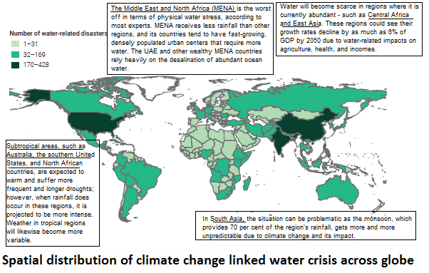
- Recent trends observed in water crises due to climate change: Risk-sensitive areas includes SIDS, semi-arid regions, coastal hinterlands and mountainous areas.
-
- SIDS will be particularly affected by this trend because of their vulnerabilities and already scarce freshwater resources. Most SIDS will experience a decrease in freshwater supply as a result of decreased rainfall and an increase in demand, triggered by growth in population and tourism.
Example: In Tuvalu, in the south pacific, 1500 of its population of 11,000 were left with no access to freshwater.
-
- Semi-arid regions: The annual potential evapotranspiration (PET) greatly exceeds annual precipitation and climate change will contribute to the long-term trend in the Aridity Index. The increasing aridity, enhanced warming and rapidly growing population will exacerbate the risk of land degradation and desertification in the near future which will impair water security through a reduction in the reliability, quantity and quality of water flows.
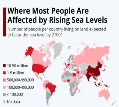
- Coastal hinterlands Coastal areas are vulnerable from the increase in sea levels, flooding, storm surges and stronger winds. More than 10% of the world’s population live in coastal areas that are less than ten meters above sea level and these areas are becoming increasingly urbanized. During this century, flooding from the rising sea level and storm surges will threaten the viability of some islands as well as some major deltas, such as the Nile and Mekong River deltas. In addition to direct impacts, this will also have severe impacts on water supply and sanitation infrastructure.
-
- Mountainous areas There is growing evidence that high-mountain areas are warming faster than lower elevations. This elevation-enhanced acceleration in warming makes mountainous areas exceptionally vulnerable to climate change. For instance, according to Mountain Research Initiative- over the past 20 years temperatures above 4,000m have warmed nearly 75 % faster than areas below 2,000m. This is most obvious from the impact on mountain glaciers and snowcaps, which show a decreasing trend almost everywhere in the world, affecting water resources for downstream populations.

- Climate change linked challenges causing water crises:
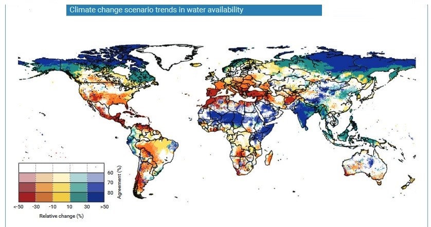
- Water availability crunch: Climate changeis already affecting water access for people around the world, causing more severe droughts and floods.

-
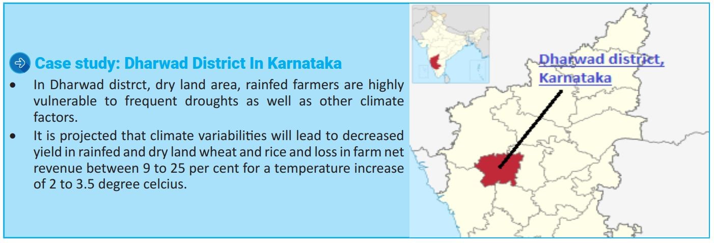
- Food security: Agriculture suffers as rainfall becomes more unpredictable and rising temperatures accelerate the evaporation of water from soil, also expected to bring more floods, which can wipe out crops, and possible crisis in the inland fishery sector prove overall threat to food security.
-
- Energy crises: Hydropower may become more expensive when the rainfall pattern changes. Reduction in river runoff due to low rainfall or sedimentation in rivers and reservoirs due to erosion and sedimentation caused by intense precipitation can significantly affect hydropower generation. States such as Kerala are already facing this situation.
- Geopolitical issues: Shortage of reliable water often leads to disputes over water sharing in trans-boundary water resources. The problem will become more serious in a country like India, with regional interests dominating national interests and vested political interests making solution and consensus difficult.
- Though migration due to water shortage associated with changing rainfall pattern has been happening for centuries, it has been accelerated in the last few decades with abnormal changes in global climate.
- Drought can also elevate risk of wildfires and dust storms that may lead to irritation of lungs and airways.
- Most vulnerable to the potential impacts of climate change, including children and elderly, the chronically ill, born with birth defects, pregnant and postpartum women, and people already suffering from mental illness. People with lower socio-economic status, migrants, refugees and the homeless may also be more vulnerable. In India, thousands of extreme poor may find it difficult to survive without safe water. Thus, the effects on physical and mental health – linked to disease, injury, financial loss and the displacement of people – are therefore likely to be considerable.
- Strategies to mitigate adverse impacts of climate change on water resource:
- To guide effective country-driven climate change adaptation, activities should reflect the importance of water management for reducing vulnerability and building climate resilience, by:
- Putting adaptive Integrated Water Resources Management (IWRM) at the centre of planning and investment for climate change adaptation.
- Promoting investment and implementation that incorporates management, restoration and sustainability of ‘natural infrastructure’ – the ecosystem services provided by healthy watersheds and coasts – and their benefits for climate resilient development of the food and energy sectors.
- Supporting actions at scale to build climate resilience by combining watershed management, sustainable infrastructure, empowerment and learning through adaptive institutions.
- To guide effective country-driven climate change adaptation, activities should reflect the importance of water management for reducing vulnerability and building climate resilience, by:

- Way forward:
- Sustainable development to keep global warming in check: Sustainable development for meeting human development goals while simultaneously sustaining the ability of natural systems to provide the natural resources and ecosystem services on which the economy and society depend on.
- Environmentalism ideology needs to be adopted at various scales: evokes the necessity and responsibility of humans to respect, protect, and preserve the natural world from its anthropogenic afflictions.
- To appreciate the idea of ‘Limits to Growth’ because it is believed that the possibilities of continuous growth have been exhausted and timely action is essential in order to avert a planetary collapse.
Where it can be used?
It can be used in topics related to Paper1 (Climate change and Environmental geography) and paper 2(Contemporary, Agriculture and Resources)
Sources:
Nuclear energy in India: Need and Prospects
Why in news: India to increase nuclear energy capacity three times in next 10 years to reduce its carbon footprints.
Need for focusing on nuclear energy in India:
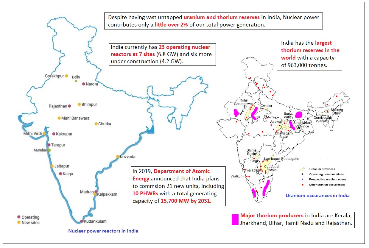
- For ensuring energy security: The recent event of massive power outages and energy crisis has once again highlighted the pitfall in India’s energy profile i.e. over dependence on coal energy. Around 55% of our energy needs are met by coal based energy which is a scarce resource. Hence there is a need for diversification of our energy profile for ensuring energy security. With untapped uranium and thorium reserves, nuclear energy can be a game changer in this regard.
- Growing energy needs: According to ‘India Energy Outlook 2021’, India will make up the biggest share of energy demand growth at 25% over the next two decades, as it overtakes EU as the world’s 3rd biggest energy consumer by 2030. Given the importance of clean energy in the era of Climate Change, nuclear energy is a viable option in addressing our growing energy needs.
- Clean energy source: Nuclear power plants produce massive amounts of carbon-free electricity. The thermal energy from nuclear reactors may also be used to de-carbonize other energy intensive sectors such as transportation- the largest contributor to carbon pollution.
- Small land footprint: Despite producing massive amounts of carbon-free power, nuclear energy produces more electricity on less land than any other clean energy source & nuclear fuel is extremely dense. To put that in perspective, it would need more than 3 million solar panels to produce the same amount of power as a typical commercial reactor or more than 430 wind turbines.
- Reliable energy source: Unlike other clean energy sources such as wind and solar, nuclear power plants run 24×7 & they are designed to operate for longer stretches and refuel every 1.5 to 2 years. Nuclear has the highest capacity factor than any other energy source.
- Energy poverty: Although India is the fourth largest energy consumer in the world, it continues to remain energy poor i.e. it’s per capita electricity consumption stood at just over 1200 KWh in 2021, whereas developed countries average is around 15,000 KWh. Thus, affordable nuclear energy can be used to address our energy poverty.

Prospects for Nuclear Energy in India:
Way forward:
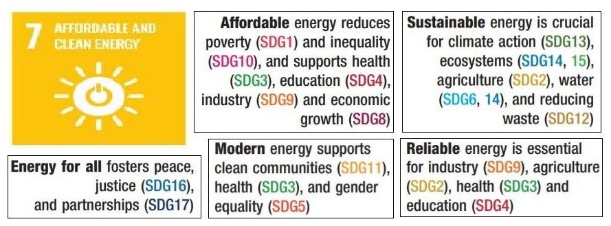
- Sustainable development: Nuclear power as clean and affordable energy is essential for realizing SDG7 which is linked to all other SDGs.
- IDSA task force report 2010, recommended for focusing on Stage 3 of our nuclear programme i.e. setting up of thorium based reactors and fuel cycle facilities as India is having the largest reserves of thorium in the world.
Where it can be used?
It can be used in topics related to Paper 1 (Energy Crisis, Sustainable development), Paper 2 (Energy Crisis, Sustainable development) and GS 3 (Energy).
Sources:
Education as a driver of rural transformation
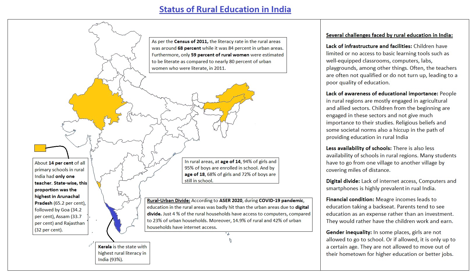
Why in news: According to a survey report, in rural areas conducted in 2021, 37% of the sample students were not studying at all and as many as 48% of the surveyed rural children were not able to read more than a few words.
How can education help in transforming rural areas?
- Employment and income opportunities: Increasing the quality of education in rural areas can significantly impact the development of employment opportunities. Studies have shown that the availability of skilled labour, transportation infrastructure, and local markets are prime factors in selecting a community for an industrial placement. Also education helps in reducing disguised unemployment in field of agriculture by enabling people to participate in more value adding jobs in Secondary & Tertiary sectors.
- Increase in productivity of rural labour force: Education improves the quality of human resources and gives skilled labour which will result in increased productivity of rural labour force, thereby increasing the wealth of a region or area.
- Improved agriculture: Education will bring knowledge in the rural populace, helping them to make informed decisions about their farms and to innovate in agricultural affairs. It also enables rural society to be aware of the new policies initiated by Government for improvement of agriculture and rural society. E.g. Soil health card scheme, Pradhan Mantri Fasal BimaYojna etc.
- Reduced migration: Improved agricultural productivity by developing scientific temper and creation of self-employment opportunities by imparting education and skills to the rural populace will bring down the rural-urban migration rates, which will also reduce the sprawl development.
- Women empowerment: Education helps women in being more aware of their rights and also improves their participation in Local Government. It also enables them to take up new entrepreneurial initiatives. Women empowerment also leads to improved HDI parameters- reduced gender inequalities, lower TFR, reduced maternal mortality, longevity etc.
- Education leads to increased level of participation of citizens in Local Government & promotes development of social capital and multi-level planning.
Way Forward:

- Rural Connectivity: Due to the difficulties of getting there, most students and teachers opt out of classes. There are no simple railway links in rural areas, which makes travelling a strenuous operation. Of course, investments in the rail networks in rural areas would strengthen the education systems.
- Digitalization of education: Digital literacy is an important part of education, especially in a world where technological advancement is the flag bearer of change. The focus is not only on infrastructure, but also on quality and creative solutions through technology to enhance educational delivery systems, especially for girls.
- Student Incentives: The mid-day meal is a perfect opportunity to go to school for students from disadvantaged backgrounds. More of these programmes should be built by the government to cater to students so that they have a reason to go to school every day.
Where it can be used?
This can be used in topics related to Paper 2 (Population Problems, Rural area development), GS 1 (Population and associated issues, Social empowerment).
Sources:
Knob and kettle topography
- What is knob and kettle topography:
Knob and kettle are landforms of glaciations wherein,
-
- A knob is a stratified geomorphologic feature which is created by deposition action of glacier meltwater. It is an irregularly shaped hill or mound composed of sand, gravel, and till, commonly associated with end moraine.
- Kettles are depressions in the outwash plains, which formed due to the melting of large ice blocks.
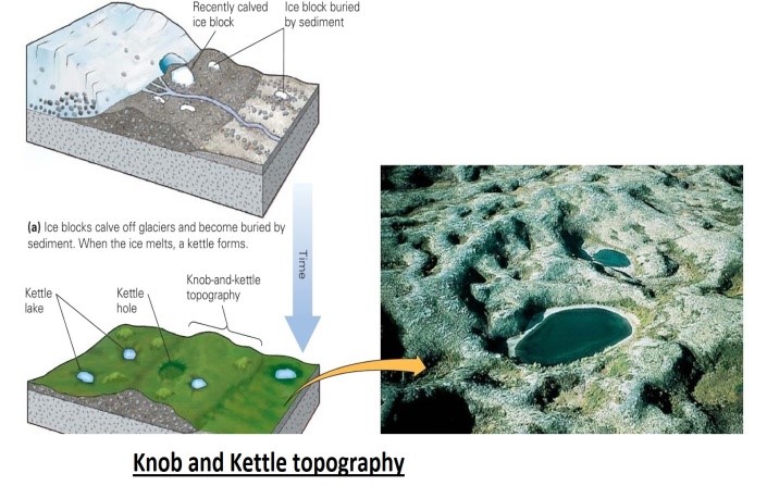
And this is also referred to as kame and kettle topography.
- Formation of knob and kettle topography:
- Knobs form when till accumulates on top of ice and fills in a depression left by the melted ice. This results in an elevated mound, often of different material than the surrounding soil
- Kettles are formed when ice becomes trapped under till and erodes downward. Glaciers commonly drop chunks of ice known as dead ice while receding due to variable rates of glacial melt and presence of subglacial features. Dry kettles are known as kettle holes. Kettles that intercept the water table fill with water and are known as kettle lakes.
- Where are they found: Kame and kettle topography is often located on end morainesbecause sediment is deposited when glaciers recede.
Example: The Fonthill Kame in southern Ontario, Kames National Natural Landscape in Washington, Minnesota- the acclaimed land of 10,000 lakes, mostly kettles lakes.
- Significance: Kame and kettle topography is an indicator of a high-discharge supraglacial and englacial drainage system of a glacier in the final stages of melt, and large quantities of glacially derived debris associated with melt water.
Sources:
SARDP-NE
- What is SARDDP-NE:
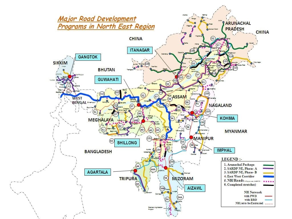
Special Accelerated Road Development Programme (SARDP-NE) is an ambitious programme for development of road network in the north eastern States of the Country.
It was launched by the Ministry of Road Transport and Highways.
-
- Implementation agencies:
- National Highway Authority of India (NHAI)
- State public work departments.
- National Highways Infrastructure Development Corporation Limited (N.H.I.D.C.L.)
- Implementation agencies:
-
- It comprises of eight states i.e. Arunachal Pradesh, Assam, Manipur, Meghalaya, Mizoram, Nagaland, Tripura and
- SARDP-NE was formulated with the following objectives:
- Up-gradation of National Highways connecting State Capitals to 2/ 4 lane;
- Providing connectivity to District Headquarter towns of NER by at least 2-lane road;
- Providing road connectivity to backward and remote areas of NE region to boost socio - economic development;
- Improving roads of strategic importance in border areas;
- Improving connectivity to neighbouring countries.
Sources:
Double-dip La-Nina
- In news: According to NOAA, the Pacific is likely to experience a rare occurrence of what is called a double dip La Niña.
- What do you mean by double-dip La-Nina?
-
- Double-dip la-Nina is the second consecutive la-Nina climate pattern emerged after a transition to ENSO-neutral conditions in the tropical Pacific.
- La Niña is the phenomenon where the trade winds become stronger, enhancing the warm pool in the western Pacific and causing the sea surface temperatures in the Central and Eastern Pacific to become cooler with above normal rainfall in the west compared to eastern Pacific.
- It is one of the components of the El Nino Southern Oscillation (ENSO)
- Usually when a La Niña occurs, it takes between 3-7 years before another one starts to developed and is followed by a neutral phase or an El Niño. However, the Pacific experienced a La Niña event towards the end of 2020 and in 2021 once again there is likely development of another. This is what is referred to as a double-dip La Niña episode.
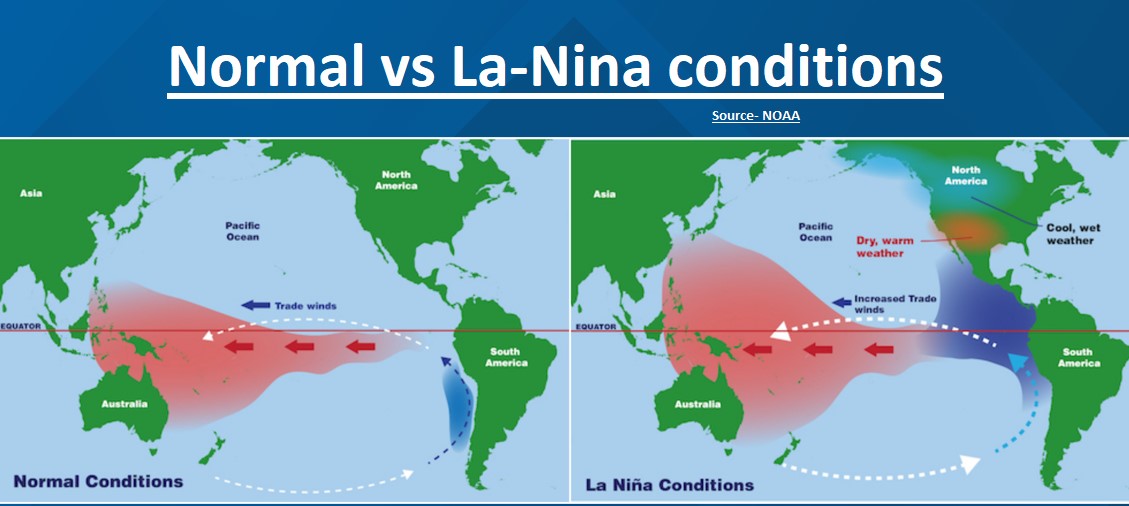
- Impact on Indian weather conditions:
- The La Nina weather pattern causes frigid winters in the northern hemisphere: North India may witness the chilliest/ extremely cold winter due to the La Nina.
- La Nina causes comparatively better SW monsoon rains in India and an increase in precipitation.
Sources:
Allied agricultural activities leading to women empowerment in the backward district of Koraput
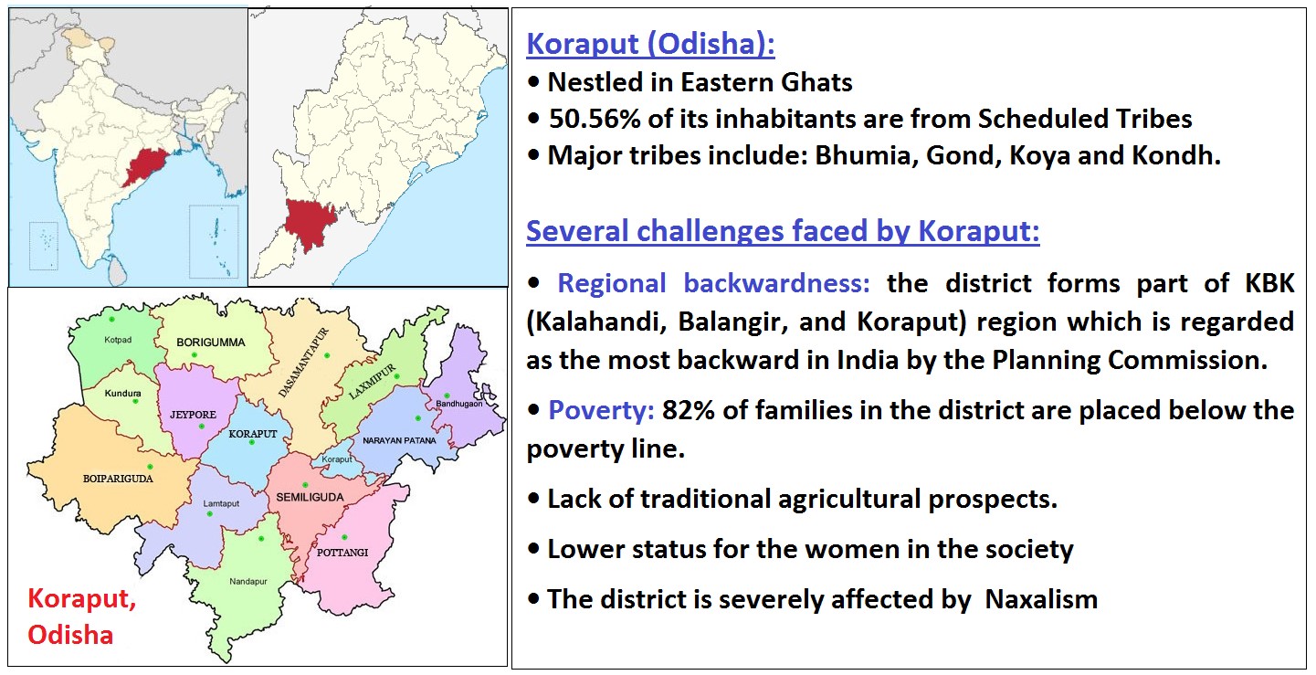
Each year, around 1,000 tonnes of turmeric is harvested in hilly areas of the district that are conducive for the plant growth. To utilize this surplus produce, ORAMS (Odisha Rural Development and Marketing Society) provided training in soap making to tribal women of the district. And ORAMS ensured financial support to the women SHGs to promote turmeric soap making from the surplus turmeric produce. These measures have yielded several benefits in this region. Such as:
- Women empowerment: Tribal women in the district are earning sustainable income by selling turmeric soaps which gave them financial independence & hence it will result in improvement of HDI indicators- decrease in Total Fertility Rate and increase in life expectancy.
- Agricultural diversification: It provided an additional means of income generation for the farmers in the region which otherwise do not have agricultural prosperity.
- Feminization of agriculture: As there is more involvement of women in the agriculture. This in turn provided benefits such as increased agricultural income output for women and reduced hunger in the region.
This can be replicated in the districts of Gujarat and Rajasthan, which are dry land regions having similar problems like lack of traditional agricultural prospects.
Where it can be used?
It can be used in topics related to Paper 2(Agriculture, tribal areas and their problems, Agricultural productivity), GS1 (Social empowerment) and GS3 (Agriculture).
Source:
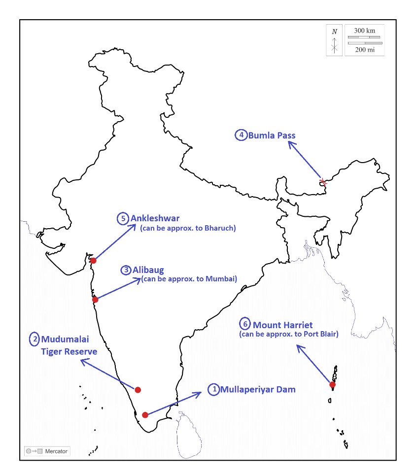
Places in news - Mullapeiyar dam
|
Mullapeiyar dam · Why in news: Mullaperiyar dam must be decommissioned, new dam needed : Kerala govt tells Supreme Court · Located on Cardamom Hills of the Western Ghats in Idukki District of Kerala. · The dam is built at the confluence of Mullayar and Periyar rivers. · Periyar national park is located around the dam’s reservoir, which is also declared as an elephant reserve. · Monsoon type of climate with short dry winters (Koppen, Amw) found in this region. · Irula and Urali tribes found in the region. |
|
Mudumalai Tiger Reserve · Why in news: After a massive hunt, Tiger MDT23 captured by the forest department. · It is located in the Nilgiri District of Tamil Nadu state at the tri-junction of three states, viz, Karnataka, Kerala and Tamil Nadu. · It is a part of Nilgiri Biosphere Reserve (1st Biosphere Reserve in India) & is bordered in the west by Wayanad Wildlife Sanctuary, in the north by Bandipur National Park and in the east by Sigur Reserve Forest. · Moyar River flows through the reserve. · It harbours tropical and subtropical moist broadleaf forests, important flora: elephant grass, bamboo, teak and rosewood. · Other Important fauna here includes Nilgiri marten and Golden jackal. |
|
Alibaug · Why in news: Alibaug white onion gets GI tag for health benefits · It’s a coastal town located in the Raigad district of Maharashtra. · Tropical wet and dry climate found here. · Vegetation: Tropical moist deciduous, Important species: teak, sal, bamboo & rosewood. · Coastal alluvium and laterite soils found here. · Agriculture is the main occupation here, important crops: Rice, Palm and coconut. |
|
Bumla Pass · Why in news: Army personnel tightened the vigilance at Bumla Pass after the India-China troops face off near Yangtse in Twang sector. · It is a mountainous pass between Tibet's Cona County and India's Tawang district in Arunachal Pradesh. · Tundra (Koppen, Et) type of climate found here. · Sangestar Tso Lake is located near to the pass. · Rhododendron Scrublands are found in this region. · Monpa tribes found in this region. |
|
Ankleshwar · Why in news: Chemical pollution is severely affecting the crops in Bharuch. · It’s a municipality located in the Bharuch district of Gujarat. · Narmada River is the important water body here. · Tropical savanna type of climate (Koppen, Aw) found here. · Tropical dry deciduous forests found here. Important species include: teak, sal, tendu and rosewood. · It is known for its chemical industries producing products such as pesticides, pharmaceuticals, chemicals and paints. |
|
Mount Harriet · Why in news: Union government renamed Mount Harriet as Mount Manipur. · It is located in South Andaman and forms part of the Mount Harriet National Park. · It is the third-highest peak in the Andaman and Nicobar archipelago next to Saddle Peak (North Andaman) and Mount Thullier (Great Nicobar). · Important fauna here includes Andaman wild pigs (an endangered species), saltwater crocodiles, Olive Ridley turtles and robber crabs & the park is also a butterfly hotspot. · Vegetation here mainly includes tropical wet evergreen forests. · Negrito tribes are found in this region. |
Share the article
Get Latest Updates on Offers, Event dates, and free Mentorship sessions.

Get in touch with our Expert Academic Counsellors 👋
FAQs
Geography Current Affairs focuses on the contemporary issues, events, and developments in the field of geography. It covers recent geographical phenomena, environmental changes, geopolitical shifts, and related news. This differs from regular geography studies which may focus more on foundational concepts, historical contexts, and theoretical frameworks.
Updates are provided regularly to ensure that subscribers stay informed about the latest developments in geography. Typically, updates are provided on a fortnightly basis, depending on the frequency of significant events and changes in the field.
Absolutely. Geography Current Affairs serves as a valuable resource not only for Geography optional but also for GS papers, especially GS Paper 1 (covering Indian Heritage and Culture, History, and Geography of the World and Society) and GS Paper 3 (covering Technology, Economic Development, Biodiversity, Environment, Security, and Disaster Management). It aids in building a holistic understanding of various topics and strengthens answer-writing skills by incorporating contemporary examples and perspectives.
Geography Current Affairs holds immense importance for UPSC preparation, particularly for aspirants opting for Geography optional. It helps candidates stay updated with the latest developments, geographical phenomena, environmental issues, and geopolitical shifts worldwide, aligning them with the dynamic nature of the subject as tested in the UPSC examinations.


