30 Apr
India’s Space Programme and its Relevance
In news
2022 looks promising for Indian Space Research Organisation (ISRO) as it goes ahead with several space missions that had been delayed due to Covid-19 in 2021.
Evolution of India’s Space Programme
- The Indian Space Programme started in 1960s. As a first step, the Department of Atomic Energy formed the INCOSPAR (Indian National Committee for Space Research) in 1962.
- The ISRO was later formed on August 15, 1969. The prime objective of ISRO is to develop space technology and its application to various national needs. It is one of the six largest global space agencies.
- Since its inception, the Indian space programme had three distinct elements: satellites for communication and remote sensing, space transportation system and application programmes.
- Two major operational systems have been established –Indian National Satellite (INSAT) for telecommunication, television broadcasting, and meteorological services and Indian Remote Sensing Satellite for monitoring and management of natural resources and Disaster Management Support.
- In 2019, India came close to landing a probe near the South Pole of the Moon. By 2023, India intends to send its first human mission to Low Earth Orbit (LEO). By 2030, India plans to develop its own independent space station.
- With its achievements, the country today is widely recognized as a global space power. The global space economy is estimated at ~US$ 423 billion. Currently, India constitutes 2-3% of the global space economy and is expected to enhance its share to more than 10% by 2030.
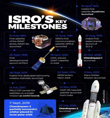
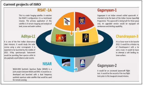
Drivers of India’s Space Program


Benefits/applications of space missions and technology

- Satellite communication: It is to address the national needs for telecommunication, tele-medicine, internet, broadcasting, tele-education etc. INSAT and GSAT series is the backbone for India’s satellite communication needs.
- Earth observation: Earth observation got applications in various areas such as agriculture, forest & environment, weather & climate, governance, rural & urban development, renewable energy etc. RISAT, Cartosat and Resourcesat are some of the prominent earth observation satellites of ISRO.
- Agriculture: Rainfall assessments from satellites, Satellite driven seasonal cropping pattern, experiments on yield estimation, land degradation maps, soil erosion maps (BHUVAN portal ) etc. help in reforming the entire Indian agriculture.

- Health and human welfare: Information from remote sensing technologies is, for instance, applied to study the epidemiology of infectious diseases. This tele-epidemiology is of particular relevance in developing countries, where infectious diseases remain among the top causes of death.
- Forestry and Natural Resource Management: In the field of forestry, space technologies are used for analysis of forest cover change, spatial biomass estimation, Community Biodiversity characterization, Forest fire alert system, etc. E.g., the flagship India State of Forest Report ustilises satellite data.
- Disaster management: Near Real Time Flood & Cyclone monitoring & mapping in the country, Flood Hazard/Risk Zonation for Flood prone states, Spatial Flood Early Warning, forest fire alerts, landslide zonation and inventory, agricultural drought studies.
- Regional and Rural Development: Space based information is being utilized for supporting decentralized planning by empowering the local bodies to prepare developmental plans. Other uses include geotagging of assets created under MGNREGA, Accelerated Irrigation Benefit Programme (AIBP), Integrated Watershed Management Programme (IWMP), Rural connectivity, Sanitation etc.
- Urban development: Various factors such as the rate of population increase, urban sprawl etc. pose the challenge to the urban environment. These change forces policy makers to plan the city in accordance. High resolution satellite data provides a tool by which these changes can be managed and planned for broad expansion of urban environments.
- Satellite-aided navigation: The GPS-aided GEO augmented navigation (GAGAN) improved accuracy and integrity, primarily for civil aviation applications and better air traffic management over Indian air space. This was followed up with the IRNSS, termed as NAVIC.
- Ocean science: In order to understand the complex nature of the ocean, the space platform is being used for observations of ocean surface and retrieval of various parameters. Currently, ISRO has three dedicated satellites in the orbit viz. Oceansat-2, SARAL and SCATSAT-1 for oceanographic observations.
- Weather and climate: Satellite technology has long been used to predict the weather, with meteorological forecasts able to act as early warning systems for extreme weather events. The technology is also key for documenting environmental changes and informing decision making by measuring sea levels, atmospheric gases and the planet’s changing temperature.
Geopolitical & Security and Strategic significance of India's space programmes

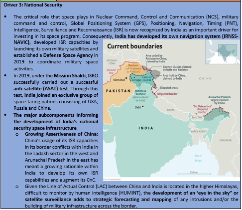
- Dedicated military satellites: India’s space programme has also been conditioned by the changing security environment. Given the larger trends in global space as well as in India’s neighborhood, India had begun developing certain military space capabilities from early 2010s.
- GSAT-7 (2013) is the India’s first dedicated military satellite augmenting India’s maritime security capabilities, especially in the Indian Ocean Region (IOR).
- Other important satellites include GSAT-6 (Indian Armed Forces) and GSAT-7A for the Indian Air Force and the Indian Army.
- In 2019, ISRO launched EMISAT (Electro-Magnetic Intelligence Satellite) for the Indian Armed Forces to strengthen the military’s ability to intercept enemy radars.
- Integrated Space Cell: It was established in 2010. It is meant to bring about better integration between different agencies and evolve a more effective way of utilizing space for military purposes.
- Gaganyaan & Global collaboration: The objective of Gaganyaan programme is to demonstrate indigenous capability to undertake human space flight mission to Low Earth Orbit (LEO), thus increasing the possibilities of collaboration with other countries.
- Peaceful use of outer space: India had long maintained a rather doctrinaire approach toward space security, emphasizing the peaceful uses of outer space and opposing the weaponization and militarization of space. Recently, the Union Cabinet approved a MoU between India and Bhutan on peaceful uses of outer space.
- In September 2020, India tested an indigenous hypersonic demonstrator vehicle powered by a scramjet engine. This test vehicle could move at six times the speed of sound and built by DRDO.
- France and India have agreed to a bilateral space security dialogue in August 2021, India becoming the first Asian country with whom France has agreed to hold such a consultation. India has such space security dialogues with two other countries, the U.S. and Japan.
Conclusion:
The Indian space program will remain a powerful expression of Indian nationalism, its way of seeking prestige globally as well as inspirational to its people. The powerful drivers of nationalism and its sub-components to include nation building, regime legitimacy, internal national development, and external status; entrepreneurship especially the role of its new commercial space sector, and national security dimensions of space including its counter space capacity will remain critical components that affect its space capacity and policy as we move forward into a second space age of lunar permanent presence, a bourgeoning space economy and space resource utilization.

Where it can be used?
It can be used in topics related to Paper 1 (Regional planning, regional development, and urban development), Paper 2 (Transport, Communication and Trade: Indian space programme, Agriculture, resources, India’s role in world affairs) and GS 3 (Internal security, science and technology)
Sources:
Western Disturbances keeping Delhi weather in a flux
Why in News?
Over the past six months, variations in the intensity and locations of western disturbances have brought heavy rainfall to Delhi during some months, and kept the city dry and in the grip of a heat wave at other times.
What is a Western Disturbance?
- A western disturbance is an extratropical storm originating in the Mediterranean region that brings snowfall over Western Himalayas and winter rains over Indo Gangetic plains.
- The term 'Western' refers to the direction from which they originate with regard to India and 'disturbance' is due to the fact that the air within the low pressure systems tends to be unstable or disturbed.
- Their impact starts from the month of October and continues until March over Western Himalayas.
- Peak intensity is during December and January when heavy snowfall occurs over hilly states of Western Himalayas leading to mudslide, landslides and avalanches.
- As the sun starts moving towards Northern hemisphere in the latter part of March, western disturbance also starts moving North over upper latitudes.

Impact of Western Disturbances on India:
- On Weather and Climatic conditions: Western Disturbances cause most of the winter and pre-monsoon season rainfall across North-West India (India gets close to 5-10% of its total annual rainfall from western disturbances).
- This phenomenon is usually associated with cloudy sky (dense clouds), higher night temperatures and unusual rain (heavy precipitation).
- In winter, western winds bring moderate to heavy rain in low lying areas and heavy snow to mountainous areas of the Indian subcontinent.
- South west monsoon covers most of India but parts of North India don’t get much rain from it. These regions depend upon rain from western disturbance during the winter season from November to March.
- The snow from the western disturbances also feed the glaciers which are the source of most of the rivers in Northern India.
- After winter the western disturbances help in the activation of monsoon in certain parts of northwest India.
- Winter rainfall and agriculture: Winter rainfall is of great significance to agriculture especially rabi crops that includes wheat. This hence is of economic importance to wheat producing states like Punjab and Haryana.
- Disaster:Unseasonable rainfall and hail brought about by western disturbances damages the crops in the North Indian states like Haryana, Punjab, Madhya Pradesh and Rajasthan.
- While weak western disturbances result in crop failure and water scarcity, strong western disturbances can cause problems such as floods across north India.
- These storms also bring about lightning in areas affected by it.
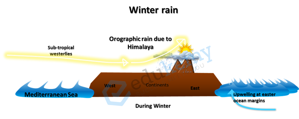
Variations in Western Disturbance impacting Delhi’s Weather
- Last year in 2021, Delhi witnessed the rainiest October in 65 years, with the national capital recording 122.5 mm of rainfall against a normal of 28 mm, on account of western disturbances.
- Excess rainfall was also recorded in January and February this year. In contrast, there was no rainfall in November and March, and the summer saw an unusually early start with heat waves setting in at the end of March.
- Multiple western disturbances that brought cloud cover had also kept the maximum temperature low in February, when the lowest maximum temperature in 19 years was recorded.
- Active western disturbances eluded northwest India in March, and absence of cloud cover and rain allowed temperatures to remain high.
- So far, Delhi has recorded eight heat wave days in April, the highest since 2010 when 11 such days were recorded. Under the influence of a western disturbance, the heat wave spell was broken recently, with the city receiving very light rainfall.
- The impact of western disturbances is not about their number, but about their location and intensity.
- In 2020, there was excess rainfall in Delhi in March. This year feeble western disturbances in March did not give any pre-monsoon weather activity even over the hills.
- Similarly, in November 2020, there was little rainfall and snowfall over western Himalayas, though intensity of western disturbances usually increases in November. By March usually, the intensity and frequency start decreasing as western disturbances start travelling in upper latitudes.
Role of Climate Change in the changing pattern of Western Disturbance:
- Global Warming has been making the world's weather more unstable and extreme.
- Recent studies have noted that the average global warming of 85 degrees Celsius is responsible for 75% of the daily heat extremes and 18% of the precipitation extremes.
- Pronounced warming over the Tibetan Plateau has increased the instability of westerlies which in turn is responsible for the increased variability of western disturbances.
- These disturbances have also been linked to the growing instability of the jet stream - strong winds that blow from west to east and separate the cold arctic mass from warm sub-tropical air.
- All these lead to a change in the pattern of western disturbances, resulting in record-breaking rainfall and heat.
Conclusion
- According to the experts, the frequency of western disturbances has increased, but not the precipitation associated with them, partly due to a warming atmosphere.
- Western disturbances are low-pressure areas. If it is a feeble western disturbance it will not have moisture to precipitate. For precipitation, moisture is needed, and by virtue of a warming atmosphere, there is less amount of moisture available to precipitate.
- Simultaneously, because of warming in atmosphere, western disturbances are going higher in elevation. In general, they move in subtropical westerly jet, now they are becoming lighter and moving higher, above 200 hectopascals.
Where to use
P1 – Climatology
P2 – Indian Climate
Source:
- How western disturbances are keeping Delhi weather in a flux
- Western disturbance to impact many parts of India
- Western Disturbances
- INTENSITY AND FREQUENCY OF WESTERN DISTURBANCES WILL REDUCE NOW
Image source:
Krummholz
Krummholz refers to the zone between treeline and more open alpine vegetation, where tree species are limited by the harsh conditions to a dense shrub growth-form as shown in the picture below. Example - Black spruce, balsam fir, and heart-leaved paper birch form masses of stunted and wind swept shrubs 0.5-2 m high.
Characteristics:
- The word krummholz is derived from German word krumm, meaning crooked, bent, or twisted; and holz for wood. High winds and frozen precipitation at high elevation causes the stunted, gnarly, and sometimes "flagged" growth forms in woody plants in this community.
- This community is restricted to the high-elevation slopes of mountainous areas generally above 3,500 feet.
- The current trend of this community is probably declining slightly due to the combined effects of atmospheric deposition and recreational overuse.
- They are vulnerable to the adverse effects of atmospheric deposition and climate change, especially acid rain and temperature increase.
- They may be threatened by development (e.g., communication towers) and recreational overuse.

Sources:
Congelifraction
- Congelifraction: Also known as frost shattering, frost wedging or congelifraction, gelifraction is the mechanical fracturing of rock caused by repeated freezing and thawing cycles. The individual fragment produced by this process is called a congelifract.
- Weathering processes under periglacial climates include ‘freeze-thaw action’, ‘contraction cracking’ and chemical weathering but freeze-thaw action is by far the most active mechanism of rock shattering.
- Congelifraction, simply known as frost weathering (Latin word congelare-to freeze and fracture-to break), includes freezing of moisture and water during night and subsequent thawing during daytime (in summer) making a complete ‘diurnal freeze thaw cycle’ which disintegrates the rocks because of continuous alternate expansion and contraction(shown in figure below).
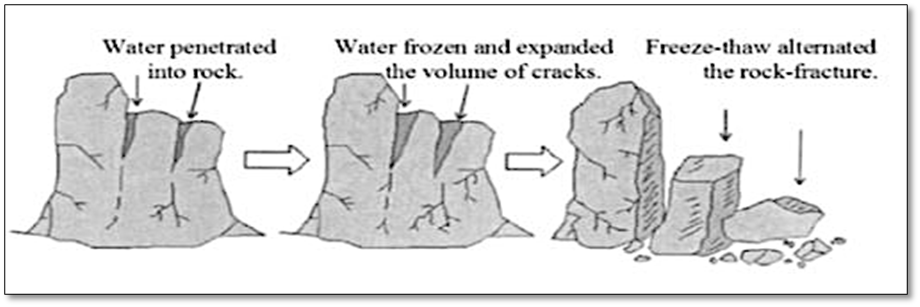
- Freeze-thaw is confined only to the active layer because it experiences temperature changes. A few periglaciologists have expressed their doubt about the effectiveness of congelifraction. Apart from the voices raised against the effectiveness of freeze-thaw weathering it is only significant process for rock-weathering and commination of larger blocks under periglacial conditions.
Sources:
Little climatic optimum
- Medieval warm period (MWP), also called medieval warm epoch or little climatic optimum (Shown in the figure below) or Medieval climate anomaly, was associated with an unusual temperature rise roughly between 750 and 1350 AD (the European Middle Ages).
- The available evidence suggests that at times, some regions experienced temperatures exceeding those recorded during the period between 1960 and 1990.
- Despite being predominantly recorded in Europe, south-western North America and in some tropical regions, the Medieval warm period affected both the northern and southern hemispheres. But the temperature increase was not universal, varying across regions of the world, and did not happen simultaneously everywhere.
- The notion of a little climatic optimum is highly controversial. Many paleoclimatologists claim that well-documented evidence for the phenomenon appears across the North Atlantic region, while others maintain that the phenomenon was global, occurring all over the world.
- Meanwhile, global warming skeptics have used the MWP to bolster their position in the debate over the nature and effects of climate change.

Sources:
Women in Chhattisgarh recreate ‘Chipko movement’ to save Hasdeo Aranya
Problem Statement
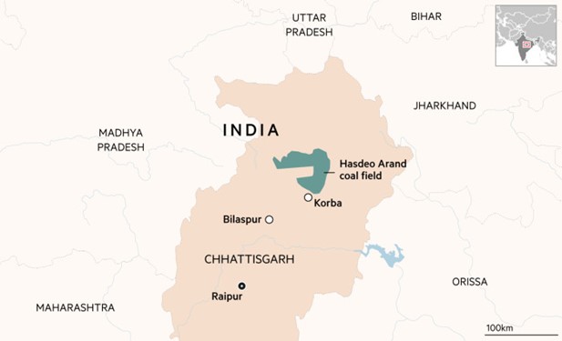
Chhattisgarh government gave the final clearance to the second phase of the Parsa East Kete Basen coal mines in the Surjapur district on April 6. Activists claim that More than 200,000 trees spread across 841 hectares of forest will have to be chopped down for the mining projects. People in the village had been protesting against the project for a long time and had been on an indefinite protest since March 2.
Ecological Significance of the Region
- The Hasdeo forest covering Chhattisgarh’s Korba, Sarguja and Surajpur districts, spans an area of 170,000 hectares. It is a noted migratory corridor and has a significant presence of elephants.
- It is also the catchment area of the Hasdeo river, the largest tributary of the Mahanadi. The area was declared as a ‘No-Go Zone’ for mining by the Centre in 2009. Despite this, mining in the region continued as the policy for the ‘No-Go Zone’ was not finalised.
Recreation of Chipko Movement to save forests
Local women in in Janardanpur village of Surajpur district of Chhattisgarh started a tree-hugging campaign on the morning of April 26, 2022, as they were being cut for the mining project in Hasdeo Aranya.
What is Chipko Movement?
- The Chipko movement was a non-violent agitation originated in Uttar Pradesh’s Chamoli district (now Uttarakhand) in 1973 that was aimed at protection and conservation of trees. It is best remembered for the collective mobilisation of women for the cause of preserving forests, which also brought about a change in attitude regarding their own status in society.
- The Chipko Andolan also stands out as an eco-feminist movement. Women led by Gaura Devi formed the nucleus of the movement, as the group most directly affected by the lack of firewood and drinking water caused by deforestation.
- The Chipko Movement gained traction under Sunderlal Bahuguna, an eco activist.
- However, the original Chipko andolan dates back to the 18th century and was started by Rajasthan’s Bishnoi community, led by a lady named Amrita Devi.
- Inspiration to Other movements
Other movements inspired by Chipko Movement
- Appiko movement (Karnataka): On September 8, 1983, the environmental activist Pandurang Hegde initiated a revolt against the agricultural practice of monoculture, which entailed the growing of a single tree in large areas. Appiko, which in the local language meant ‘to hug’, was a method that Hegde owed to the Chipko movement and actively propagated in his region through local folklore. The movement played an instrumental role in saving a rather eco-sensitive habitat of the Western Ghats.
- Campaign to save trees in North 24 Parganas (West Bengal): As recent as April 2017, the Chipko Movement was yet again replicated by a group of young boys and girls in West Bengal to save close to 4000 trees on the NH112 which wer being cut for its broadening.
Chipko movement in Japan: In 2009, the Japanese too followed the Chipko way, when the local population staged a strong protest against the building of a tunnel near Mount Takao. They too adopted the tree-hugging method to resist the agenda of the local administration.
Source:
- Women in Chhattisgarh recreate ‘Chipko movement’ to save Hasdeo Aranya
- Three environmental agitations inspired by the Chipko movement
Image source
Chenab River
|
Chenab River
|
|
Shinku La Pass
|
|
Pulicat Lake
|
|
Indravati Tiger Reserve
|
|
Nallamala Hills
|
|
Orang National Park
|

Share the article
Get Latest Updates on Offers, Event dates, and free Mentorship sessions.

Get in touch with our Expert Academic Counsellors 👋
FAQs
Geography Current Affairs focuses on the contemporary issues, events, and developments in the field of geography. It covers recent geographical phenomena, environmental changes, geopolitical shifts, and related news. This differs from regular geography studies which may focus more on foundational concepts, historical contexts, and theoretical frameworks.
Updates are provided regularly to ensure that subscribers stay informed about the latest developments in geography. Typically, updates are provided on a fortnightly basis, depending on the frequency of significant events and changes in the field.
Absolutely. Geography Current Affairs serves as a valuable resource not only for Geography optional but also for GS papers, especially GS Paper 1 (covering Indian Heritage and Culture, History, and Geography of the World and Society) and GS Paper 3 (covering Technology, Economic Development, Biodiversity, Environment, Security, and Disaster Management). It aids in building a holistic understanding of various topics and strengthens answer-writing skills by incorporating contemporary examples and perspectives.
Geography Current Affairs holds immense importance for UPSC preparation, particularly for aspirants opting for Geography optional. It helps candidates stay updated with the latest developments, geographical phenomena, environmental issues, and geopolitical shifts worldwide, aligning them with the dynamic nature of the subject as tested in the UPSC examinations.

