
24 Dec to 10 Jan, 2026
CLIMATE RESILIENT AGRICULTURE - 10 January 2026
Why in news: There is renewed focus on Climate-Resilient Agriculture (CRA) as a strategic necessity for ensuring India’s food security, safeguarding farmer livelihoods, and achieving long-term sustainability.
About:
Climate Resilient Agriculture (CRA) refers to an agricultural approach that anticipates, absorbs, adapts to, and recovers from climate-related shocks and stresses—such as droughts, floods, heatwaves, cyclones, and erratic rainfall—while maintaining or improving agricultural productivity and farmers’ livelihoods.
Brief Comparison with Related Concepts
|
Aspect |
Climate Resilient Agriculture (CRA) |
Climate-Smart Agriculture (CSA) |
Sustainable Agriculture |
Agroecology |
|
Primary Goal |
Cope with and adapt to climate risks |
Triple win: productivity, adaptation, mitigation |
Long-term resource sustainability |
Ecological harmony and social justice |
|
Core Emphasis |
Resilience to climate shocks |
Productivity + resilience + low emissions |
Environmental, economic continuity |
Ecological processes & biodiversity |
|
Time Horizon |
Short–to–medium term (shock-oriented) |
Medium–to–long term |
Long term |
Long term |
|
Climate Risk Focus |
Very high |
High |
Moderate |
Indirect |
|
Adaptation Focus |
Central pillar |
One of three pillars |
Secondary |
Implicit |
|
Mitigation (GHG reduction) |
Not mandatory |
Explicit pillar |
Indirect |
Often implicit |
|
Technological Orientation |
Context-specific, pragmatic |
Often tech-driven |
Balanced |
Low external input |
|
Farmer Vulnerability Lens |
Strong (smallholders, rainfed regions) |
Moderate |
Moderate |
Strong (community-based) |
CLIMATE RISKS TO AGRICULTURE
Climatic Stressors
1. Temperature Rise
- Rising mean temperatures and more frequent heatwaves shorten crop growth periods, reduce grain filling, and increase evapotranspiration. Each 1°C rise can reduce wheat yields by ~6–10% in tropical regions.
2. Rainfall Variability
- Climate change increases erratic rainfall: fewer rainy days but higher-intensity rainfall.
3. Sea-Level Rise (Coastal Agriculture)
- Leads to salinisation of soils and groundwater, reducing crop suitability.Sundarbans and Krishna–Godavari delta face declining rice productivity due to saline ingress.
Vulnerabilities in the Agricultural System
- Crop Failures : Stress at sensitive stages (flowering, grain filling) causes total yield collapse, not incremental loss.
- Livestock Stress : Heatwaves in Rajasthan and Gujarat reduce milk output and increase mortality in poultry.
- Soil Degradation: Black soils in Deccan plateau crack under heat, reducing moisture retention.
- Pest and Disease Outbreaks : Climate change can increase pest damage by 10–15% in major cereals.Fall Armyworm spread rapidly across Indian maize belts after favorable climatic conditions.
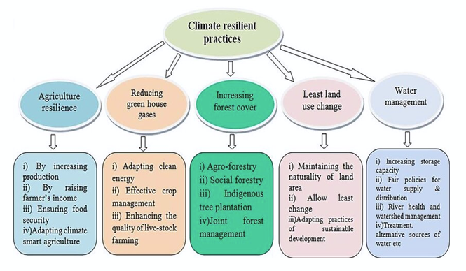
Pillars of Climate Resilient Agriculture (CRA)
- Climate Risk Anticipation & Preparedness : Ability of farmers to foresee climate stress and take preventive decisions before damage occurs.
- Agro-met advisories can reduce crop losses by 15–25%.
- India: IMD–ICAR advisories help farmers delay sowing during weak monsoon years.
- Example: Advance cyclone warnings allow coastal farmers to harvest early or shift livestock.
- Adaptive & Diversified Farming Systems : Reducing dependence on single crops or seasons to spread climate risk.
- Drought-tolerant crops reduce yield loss by 30–50% during dry spells.
- Sub-1 rice survives up to 14–17 days of flooding.
- Millets require less water and withstand high temperatures.
- Natural Resource & Ecosystem Resilience : Strengthening soil, water, and ecosystems so they can absorb and recover from climate stress.
- A 1% increase in soil organic carbon raises water-holding capacity by ~20%.
- Micro-irrigation saves 30–50% water and reduces heat stress on crops.
- Watershed development stabilizes yields in drought-prone regions.
- Socio-Economic & Institutional Resilience : Ensuring farmers can recover quickly after climate shocks.
- Crop insurance reduces post-disaster income shocks.
- PMFBY (India) provides financial protection against droughts, floods, and cyclones.
- FPOs improve bargaining power and reduce risk for small farmers.
Role of Farmers and Local Communities in Climate-Resilient Agriculture (CRA)
- Custodians of Indigenous and LocalKnowledge: Farmers possess context-specific knowledge about soils, crops, weather patterns, and ecosystems built over generations. Koraput (Odisha) tribal farmers conserve hundreds of traditional rice landraces, many tolerant to moisture stress and pests.
- On-Farm Innovation andAdaptation: Farmers continuously experiment and adapt practices in response to changing climate conditions.
- Community-Based Natural ResourceManagement: Local communities collectively manage soil, water, forests, and grazing lands, which are central to resilience. Community-managed tanks in Tamil Nadu sustain irrigation during dry spells. Joint forest management improves micro-climate and reduces erosion.
- Participatory ClimateGovernance : Local communities act as co-implementers and monitors of climate policies. Community involvement increases success rates of watershed and adaptation projects. NICRA villages show higher adoption of climate-resilient practices where farmers participate in planning.
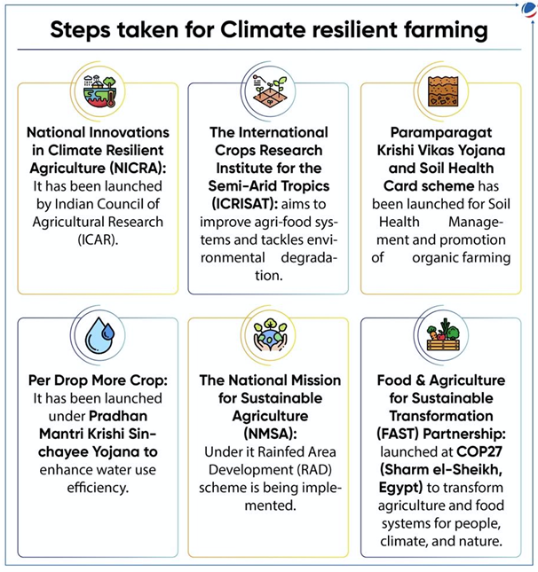
National and Global Initiatives for Climate-Resilient Agriculture (CRA)
- NICRA – National Innovations on Climate Resilient Agriculture: Technology demonstration, risk management, and capacity building.
- National Mission for Sustainable Agriculture (NMSA) : Part of National Action Plan on Climate Change (NAPCC) , Enhances resource resilience.
- Pradhan Mantri Fasal Bima Yojana (PMFBY): Financial protection against climate-induced crop loss. Insurance coverage for droughts, floods, cyclones, hailstorms.
Global Initiatives
- FAO – Climate-Smart Agriculture (CSA)Framework : Productivity, adaptation, mitigation.Significance: Provides a global adaptation roadmap.
- Global Alliance for Climate-Smart Agriculture (GACSA) :Knowledge sharing, partnerships.
Significance: Accelerates global adoption of resilient practices. - CGIAR Climate ResearchProgramme(CCAFS) : Climate risk modelling, resilient crops, food systems.Significance: Strong science–policy interface.
- Green Climate Fund (GCF) :Financing climate adaptation in developingcountries.Funding climate-resilient agriculture projects in Asia and Africa.
Significance: Addresses adaptation finance gap
Way Forward and Solutions for Climate-Resilient Agriculture (CRA)
- Mainstream Climate Risk into Agricultural Planning : Integrate climate risk assessment into crop planning, MSP decisions, and input supply.Use district-level climate vulnerability mapping.
- Scale Climate-Resilient Technologies (Beyond Pilots):Mass adoption of stress-tolerant seeds, micro-irrigation, and protectiveinfrastructure.Incentivise adoption through subsidies and credit.
- Promote Diversified and Climate-AdaptiveFarming :Move away from mono-cropping towards diversified and integrated systems. Encourage millets, pulses, agroforestry, and livestock integration.
- Improve Climate Services and Last-Mile Advisory : Strengthen weather forecasting, digital advisories, and extension networks. Use mobile-based advisories and AI tools.
- Align Agriculture with Climate Finance and Global Goals : Leverage climate finance (GCF, adaptation funds).Align agriculture with SDGs and NDCs.
Source:
ROCKIES, ALPS, HIMALAYAS: MORE RAIN...
Why in news ?: The switch from snowfall to rainfall could increase the risk of disasters such as floods, landslides, and soil erosion.
About:
- According to new study , The Himalayas and other mountains across the Northern Hemisphere are likely to see 15 % more rain for every 1-degree Celsius rise in temperature due to climate change.
- Climate change could cause a shift in snowfall to rainfall in mountain regions across the Northern Hemisphere, amplifying rainfall extremes, increase the risk of disasters such as floods, landslides, and soil erosion.
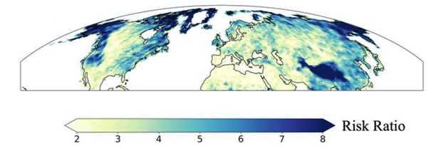
Areas in the darkest blue are 8 times more likely to experience an extreme rainfall event (compared to 1950-1979)
- Data from 1950-2019 already shows that this transition from snowfall to rainfall has already been set in motion in the mountain regions of the Northern Hemisphere.
- It will continue to increase at a rate of 15 per cent for every 1 degree Celsius rise in temperature. For 2 degrees and 3 degrees rise, the world would see a 30 per cent and 45 per cent increase in rain, respectively.
- Findings revealed that Himalayas and the North American Pacific Mountain ranges, including the Cascades, Sierra Nevada, and coastal ranges from Canada to Southern California are more threatened than the Rockies or the Alps.
- In fact, our data shows that the Himalayas are likely to see higher rates of increase than other mountainous regions.
- The higher risk might be due to changes in atmospheric dynamics.
- The North American Pacific Mountain range, for example, see a significant portion of snowfall at temperatures just below zero degrees Celsius. A change in air temperature will shift this snowfall to rainfall.
- The research team did not consider mountain regions in Southern Hemisphere due to a paucity of data from the pre-satellite era (before 1979).
- Reports from International Centre for Integrated Mountain Development (ICIMOD) found that the Hindu Kush Himalayas have seen a 65 per cent faster loss of glacier mass.
- Report quoted a study that predicted a decline in snowfall by 30-50 per cent in the Indus Basin, 50-60 per cent in the Ganges, and 50-70 per cent in the Brahmaputra between 2070 and 2100 compared to the average snowfall between 1971 and 2000.
Where to use ?
Paper I ( Geography optional ) : Global Climatic change
Source :
HUGE GRAVITY HOLE
Why in news ?
Researchers at the Indian Institute of Science (IISc) Bangalore have identified the cause of an over three million square kilometres-wide 'gravity hole' in the Indian Ocean.
About:
- According to scientist, huge gravity hole in the middle of Indian Ocean is not a physical hole but an area in Indian Ocean where gravity of Earth is lower than average.
- The gravity hole, known as the Indian Ocean geoid low was possibly due to plumes of molten rock which was rising from the remains of an ancient hotbed.
Gravity varies across Earth
- Dense continent can have more gravitational force than a zone where the crust is thinner. But, the variation in gravity in the Indian Ocean is contrasting.
Movement of tectonic plates
- Geophysicist discovered that the possible reason for the gravity hole is the plumes of magma.
- The phenomena might have originated 120 million years ago when the supercontinent Gondwana land separated.
- As the Indian plate separated from the African plate, it smashed into the European plate and the ocean called Tethys was squeezed between the continental plates.
- Some parts of these plates are still melting back into the deep Earth's interior and generating low-intensity magma and creating a gravity hole.
Where to use ?
Paper I ( Geography optional ) : Bottom topography of Indian Ocean
Source:
Wolf Supermoon
Wolf Supermoon: A Wolf Supermoon is a full Moon that occurs when the Moon is at or near its closest point to Earth in its elliptical orbit, a position known as perigee. Because of this proximity, the Moon appears noticeably larger and brighter than an average full Moon—about 7–14% bigger in size and up to 30% brighter. The term “Wolf Moon” comes from Native American traditions, where the full Moon of January was associated with the howling of wolves during the harsh winter months. The word “supermoon” refers only to the Moon’s distance from Earth and has no destructive impact; at most, it can slightly enhance ocean tides, but it does not cause earthquakes or disasters.
New Urbanism
New Urbanism: New Urbanism is an urban planning and design approach that seeks to create compact, walkable, and mixed-use neighbourhoods that prioritize people over automobiles. It emerged as a response to uncontrolled urban sprawl, traffic congestion, environmental degradation, and social isolation seen in modern cities. The concept emphasizes dense settlements, public spaces, pedestrian-friendly streets, and proximity between homes, workplaces, and services. Well-known examples include Seaside in Florida and Poundbury in the United Kingdom. In the Indian context, ideas similar to New Urbanism are visible in Transit-Oriented Development projects, which aim to reduce dependence on private vehicles and promote sustainable urban living.
Common But Differentiated Responsibilities (CBDR)
Common But Differentiated Responsibilities (CBDR): Common But Differentiated Responsibilities is a foundational principle of international environmental law that recognizes that while all nations share responsibility for protecting the global environment, their obligations differ based on historical contributions to environmental degradation and their respective capacities. The principle was formally articulated in Principle 7 of the Rio Declaration (1992) and later embedded in frameworks such as the UNFCCC and the Kyoto Protocol. Developed countries, having historically emitted higher levels of greenhouse gases, are expected to take the lead in emission reductions and provide financial and technological support. Developing countries, including India, emphasize CBDR to argue for climate justice and equitable development space within global climate negotiations.
Monocotyledon (Monocot)
Monocotyledon (Monocot): Monocotyledons, commonly known as monocots, are a major group of flowering plants whose seeds contain a single embryonic leaf, or cotyledon. They are typically characterized by parallel leaf venation, fibrous root systems, scattered vascular bundles, and floral parts arranged in multiples of three. Monocots include some of the world’s most important crops such as rice, wheat, maize, sugarcane, and millets, as well as plants like bamboo, palms, and grasses. Their significance is immense, as they form the backbone of global food security and are often better adapted to varying climatic conditions, particularly in tropical and semi-arid regions.
Data Carbon
Data Carbon Ladder: The Data Carbon Ladder is a tool designed to measure and assess the carbon emissions generated by digital data usage, highlighting the often-overlooked environmental footprint of the digital economy. Every digital activity—such as data storage, cloud computing, video streaming, and data transmission—consumes energy, largely through data centres that rely heavily on electricity. The Data Carbon Ladder enables organisations to calculate emissions associated with their digital data, identify inefficiencies, and adopt strategies to reduce or offset their carbon footprint. By encouraging practices such as minimizing redundant data storage and optimizing digital infrastructure, this tool supports greener information technology systems and contributes to broader climate mitigation efforts.
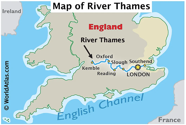
River Thames (London, UK)
Baseline problem: how bad it got
- By the mid-20th century, parts of the Tidal Thames were so polluted (untreated sewage + industrial effluents) that in 1957 stretches were declared “biologically dead”—meaning they could not sustain normal aquatic life.
Pollution profile (typical of industrial-era rivers):
- High organic load (sewage) → oxygen crash → fish kills
- Industrial chemicals/metals → toxic stress + bioaccumulation
- Urban storm overflows → episodic spikes in pollution during rain
Measures :
- Tighter industrial regulation + enforcement
- Controls on industrial effluents reduced toxic inputs; industries could not treat the river as a cheap disposal channel.
- Basin-scale monitoring (feedback loop)
- Regular, catchment-wide monitoring helped identify hotspots, measure progress, and justify further upgrades.
- Habitat revival alongside pollution control
- Protecting/maintaining estuarine and tidal habitats supports biodiversity recovery once water quality improves.
Outcomes
- Fish diversity: The Tidal Thames supports 115 fish species (reported using Environment Agency data).
- Bird diversity: About 92 bird species recorded (BTO data in the same synthesis).
- Habitat extent: Almost 600 hectares of saltmarsh associated with the tidal system (Environment Agency data as compiled in the report).
Places in News - 10 January 2026
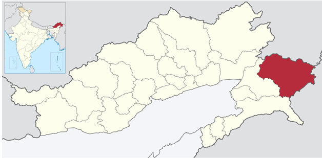
1. Anjaw
Why in news : Arunachal celebrated the inaugural Sunrise Festival 2025-26 at Dong village in Anjaw district, the easternmost point where sunrise first touches Indian territory.
About:
- It is an administrative district in the state of Arunachal Pradesh in north-east India.
- Hawai, at an altitude of 1296 m above sea level, is the district headquarters, located on the banks of the Lohit River, a tributary of the Brahmaputra River. Anjaw is the easternmost district in India.
- The Mishmi, and the Zakhring (formerly called Meyor) are the main tribes in the district.
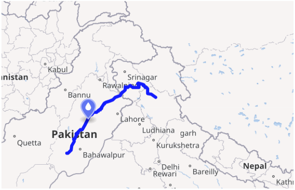
2. Chenab River
Why in news : The Ministry of Environment, Forest and Climate Change (MoEF&CC)’s Expert Appraisal Committee (EAC) has recommended an environmental clearance for the Dulhasti Stage-II hydropower project.
About:
- The Chenab River is a major river in India and Pakistan, and one of the five major rivers associated with the Punjab region.
- It is formed by the union of two headwaters, the Chandra and Bhaga, which rise in the upper Himalayas in the Lahaul region of Himachal Pradesh, India. \
- The Chenab then flows through the Jammu region of Jammu and Kashmir, India, into the plains of Punjab, Pakistan, where it joins the Sutlej River to form the Panjnad, which ultimately flows into the Indus River at Mithankot.
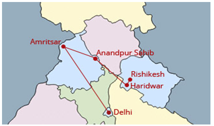
3. Anandpur Sahib
Why in news : Punjab has officially declared Amritsar, Anandpur Sahib, and Talwandi Sabo as holy cities due to their deep Sikh heritage, as each hosts one of the faith’s five Takhts.
About:
- Anandpur Sahib, also referred simply as Anandpur (lit. 'city of bliss'), is a city in Rupnagar district (Ropar), on the edge of Shivalik Hills, in the Indian state of Punjab.
- Located near the Sutlej River, the city is one of the most sacred religious places in Sikhism.
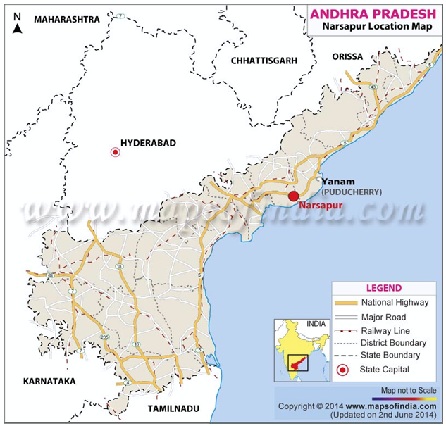
4. Narsapur
Why in news : The traditional crochet lace craft of Narasapur in Andhra Pradesh exports crossed ₹150 crore in the current financial year, marking a strong revival of the craft after the Covid-19 setback.
About:
- It is one of the Famous town in West Godavari District.
- It derived it's name from Nav Shah , means 9 wali allah who came from Madina Munawwarah to show the people the right path .
- The One of the Branch River of Godavari Named Vasishta flew beside this town and merged in Bay of Bengal near to this town.
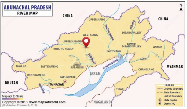
5. Subansiri Lower Hydroelectric Project.
Why in news : The Union Minister of Power, Housing & Urban Affairs inaugurated the commercial operation of Unit–2 (250 MW) of the Subansiri Lower Hydroelectric Project.
About:
- A major tributary of the Brahmaputra river
- Also known as “Gold River”
- Flows along the border of Arunachal Pradesh and Assam
- Origin – Tibetan Himalayas
- Entry into India – through Miri Hills of Arunachal Pradesh.
- The significant variation in its topography presents an opportunity for harnessing hydropower potential in the region.
Fortnightly KOSMOS MCQs Practice - 10th January 2026
Q1. Consider the following statements regarding the International Union for Conservation of Nature:
1. The IUCN is a membership union consisting solely of government organizations.
2. The IUCN Red List of Threatened Species is the most comprehensive global inventory of the conservation status of plant and animal species.
Which of the statements given above is/are correct?
- Only 1
- Only 2
- Both 1 and 2
- Neither 1 nor 2
Q2. With reference to Indian Ocean Dipole ( IOD ) , consider the following statements:
1. IOD is said to be positive when the western side of the Indian Ocean, near the Somalia coast, becomes warmer than the eastern Indian Ocean.
2. IOD is said to be negative when the western side of the Indian Ocean, near the Somalia coast, becomes cooler than the eastern Indian Ocean.
Which of the above mentioned statements is/ are correct ?
- Only 1
- Only 2
- Both 1 and 2
- Neither 1 nor 2
Q3. Consider the following pairs:
Places. : Nearby location
1. Kedarnath. : On the way of Sonprayag
2. Badrinath. : On the way of Joshimath
3. Yamunotri. : On the way of Rudraprayag
Which of the above mentioned pairs are correct?
- One pair
- Two pairs
- Three pairs
- None
Q4. Consider the following statements regarding Bald Eagle:
1. It breeds in Russia, Kazakhstan, and Mongolia during the winter season.
2. The bird has moved from ‘Least Concern’ to ‘Endangered’ under IUCN Red List.
Which of the above mentioned statements is/ are correct ?
- Only 1
- Only 2
- Both 1 and 2
- Neither 1 nor 2
Q5. Consider the following:
1. Antimony and copper
2. Erbium and Rhodium
3. Potash and Barite
Which of the above mentioned pairs are considered as Critical minerals in India ?
- One pair
- Two pairs
- Three pairs
- None
Q6. With reference to Coalition for Disaster Resilient Infrastructure , consider the following:
1. It is a global partnership of national governments, United Nations and private sector, on promoting the resilience of infrastructure systems to climate risks.
2. It is anchored on the four priorities for action set out in the Sendai Framework.
Which of the above mentioned statements is/ are correct?
- Only 1
- Only 2
- Both 1 and 2
- Neither 1 nor 2
Q7. With reference to Green Credit Programme , consider the following statements:
1. The ‘Green Credit’ means a singular unit of an incentive provided for a specified activity, delivering a positive impact on the environment.
2. It was first announced in the 2023 -24 Union Budget with a view to leverage a competitive market-based approach and incentivize voluntary environmental actions of various stakeholders.
Which of the above mentioned statements is/ are correct?
- Only 1
- Only 2
- Both 1 and 2
- Neither 1 nor 2
Q8. Consider the following statements regarding Debrigarh wild life sanctuary:
1. It is located in the Kandhmal district of Odisha.
2. It also forms the catchment area of the Jonk River.
3. The sanctuary is bound on the east and north by the huge Hirakud reservoir.
Which of the above mentioned statements are correct ?
- Only one statement is correct
- Only two statements are correct
- Only third statement is correct .
- All three statements are correct.
Q9. With reference to Binsar Wildlifesanctuary ,consider the following statements:
1. The sanctuary is located in the Kumaon Hills of Uttarakhand .
2. It was named after the Bineshwar Mahadev temple, a 16th-century temple dedicated to Lord Shiva.
Which of the statements given above is/are correct?
- Only 1
- Only 2
- Both 1 and 2
- Neither 1 nor 2
Q10. Consider the following tribes:
1. Shompen
2. Onges
3. Todas
4. Sentinelese
How many of the tribes mentioned above are indigenous to the Andaman and Nicobar Islands?
- Only one
- Only two
- All three
- None
Share the article
Edukemy’s Current Affairs Quiz is published with multiple choice questions for UPSC exams
MCQ
Get Latest Updates on Offers, Event dates, and free Mentorship sessions.

Get in touch with our Expert Academic Counsellors 👋
FAQs
Geography Current Affairs focuses on the contemporary issues, events, and developments in the field of geography. It covers recent geographical phenomena, environmental changes, geopolitical shifts, and related news. This differs from regular geography studies which may focus more on foundational concepts, historical contexts, and theoretical frameworks.
Updates are provided regularly to ensure that subscribers stay informed about the latest developments in geography. Typically, updates are provided on a fortnightly basis, depending on the frequency of significant events and changes in the field.
Absolutely. Geography Current Affairs serves as a valuable resource not only for Geography optional but also for GS papers, especially GS Paper 1 (covering Indian Heritage and Culture, History, and Geography of the World and Society) and GS Paper 3 (covering Technology, Economic Development, Biodiversity, Environment, Security, and Disaster Management). It aids in building a holistic understanding of various topics and strengthens answer-writing skills by incorporating contemporary examples and perspectives.
Geography Current Affairs holds immense importance for UPSC preparation, particularly for aspirants opting for Geography optional. It helps candidates stay updated with the latest developments, geographical phenomena, environmental issues, and geopolitical shifts worldwide, aligning them with the dynamic nature of the subject as tested in the UPSC examinations.