
08 Jan
Poverty in India- Challenges &Way Forward
In News
NITI Aayog recently released the first ever National Multidimensional Poverty Index (MPI).
Introduction
- Poverty refers to socially perceived deprivation in terms of basic human needs.It has both material (deprivation in consumption including items such as food, clothing, durables, shelter, health, education) and nonmaterial dimensions (discrimination based on gender, religion, race or caste).
- Poverty as a complex and multidimensional problems have close association with the geography of region, strategies of industrial development at global and national levels and how it has impacted the local people.

Dimensions of Poverty in India
The two main dimensions of poverty in India are: i) Regional dimensions of poverty ii) Social dimensions of poverty.
The Regional Dimensions of Poverty:
- India’s national MPI identifies 01% of the population as multidimensionally poor.
- Rural Poverty stands at 32.75% while Urban Povertyratiois 8.81%.
- Following Maps and the adjacent infographic show the regional dimensions of poverty based on MPI Score.

Social Dimension of Poverty
- Poverty in India is not merely an economic phenomenon but also a social one spread across caste, gender and within family.

Challenge of Poverty in India
- Multidimensionality of Poverty: Poverty can’t be measured based on income alone.It has multiple factors of deprivation as captured in National MPI.
- The MPI is based on three dimensions - health, education, and standard of living - with each having a weighting of one-third in the index. These dimensions are further based on 12 segments (refer to the infographic titled ‘THE OTHER INDIA’).

- Social Exclusion: According to this concept, poverty must be seen in terms of the poor having to live only in a poor surrounding with other poor people, excluded from enjoying social equality of better-off people in better surroundings. Social exclusion can be both a cause as well as a consequence of poverty in the usual sense.
- Example: the working of the caste system in India in which people belonging to certain castes are excluded from equal opportunities.
- Vulnerability: Vulnerability to poverty is determined by the options available to different communities for finding an alternative living in terms of assets, education, and health and job opportunities. Further, it is analysed on the basis of the greater risks these groups face at the time of natural disasters (earthquakes, tsunami), terrorism etc. Further challenge is their social and economic ability to handle these risks.
- Agriculture based population: Agriculture is the primary source of livelihood for about 58% of India’s population. Over 85% of the farmers are small and marginal with less than 2 hectares of land. According to the ‘Situation Assessment of Agricultural Households and Land and Holdings of Households in Rural India 2019’, the average monthly income from different sources per agricultural household in July 2018 to June 2019 comes to only ₹10,218.

- Feminisation of Poverty: Feminisation of Poverty is a collective effect of several factors, be it access to education or lack of health facilities that are available for women. Feministic Geography argues that the patriarchal culture prevents investment in women’s education, health and skill development.
- Labour of women is often primarily in terms of unpaid family care and household duties. Moreover, women's jobs are more likely to be informal employmentthan men and there are huge wage gaps compared to men.
- Accessibility and security issues are other factors which discourage women from getting into productive employment.
- Poverty and Inequality:According to the World Inequality Report, the top 1% of the population in India owns more than one-fifth of the total national income in 2021 while the bottom half earns just 13.1%.According to the Human Development Index (HDI) 2019 report, there is another type of poverty coming in because of inequalities.
- The old inequalities were based on access to health services and education whereas the next generation of poverty is based on technology, education and climate, according to the report. India has both types of poverty. Even as Indians continue to face a lack of access to healthcare and education, many others are becoming poor based on the new criteria.
- Human Development Index (HDI) and Poverty: Poverty compromises on the indicators of HDI which captures three socially useful choices - the choice to lead a long and healthy life; the choice to acquire knowledge; and iii) to have access to the resources needed for a decent level of living.
- India’s HDI value for 2019 is 0.645—the medium human development category—positioning it at 131 out of 189 countries and territories.
- Institutions and poverty: In an economy, good governance leading to non-discriminatory judiciary system, control of corruption, system to exercise democratic rights and market-friendly policies facilitates economic development and poverty reduction.
- Geography plays an important role. For instance majority of tribal population remain located in hard to accessible locations in the hills, or forests. Similarly, the displacement induced by the exploitation of natural resources such as mineral mining or dam construction lead to aggravation of poverty in natives.The experiences of Indian Naxal movement highlight the reality of deprivation and its relation to space and development policy.
- Impact of COVID: Pew Research Center has estimated that the number of poor in India (with income of $2 per day or less in purchasing power parity) has more than doubled to 134 million from 60 million in just a year due to the pandemic-induced recession. This means, India is back in a situation to be called a “country of mass poverty” after 45 years.
Way Forward: Strategy to Combat Poverty
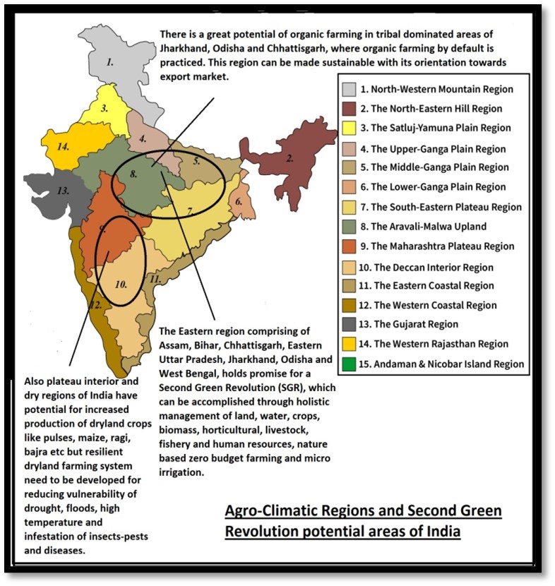
- Poverty Reduction by Agricultural Growth: Recommendations of the NITI Aayog Taskforce on Agricultural Development for agriculture development should be implemented. These includeraising productivity in agriculture, giving remunerative prices to farmers, ‘2ndgreen revolution’ in rain fed areas in general and eastern India in particular, diversification into high value crops, reform of tenancy laws to help small and marginal farmers, and building safety nets to bring quick relief for farmers in times of natural disasters.
- Employment Intensive Manufacturing and Services:The growth of organized labour-intensive sectors e.g., textile, footwear, food processing, construction and retail trade to utilizeincreasing workforce is the need of hour.
- Development of Coastal Economic Zones(CEZs) can provide the focal point for export-oriented employment-intensive large-scale firms that are currently exiting China in response to high and rising wages and declining size of labour force.
- Making Anti-poverty Programs More Effective: Making anti-poverty programs such as the Public Distribution System (PDS), Midday Meal Scheme, MGNREGA and Housing for All more effective represents the 2ndleg of the strategy to eliminate abject poverty.
- Skill Development under MGNREGA:This would pave the way for many workers to exit the program and further get into some more productive and remunerative work. In this regard, government is skilling the MGNREGS workers through Project Livelihoods in Full Employment- 'LIFE-MGNREGA’ andBarefoot Technician program.
- New Approaches to Combating Poverty: Apart from making the existing central government anti-poverty program more effective, additional innovative programs that may be helpful in speeding up poverty reduction. For instance, NITI Aayog suggests Lifting the Five Poorest Families in Each Village out of Poverty.
- Each Gram Panchayat may be asked to identify 5 poorest families in the village and endeavor to lift them out of poverty. Panchayat may ensure that these families get all government benefits.

Conclusion: Poverty in its multidimensionality needs multidimensional approach. Here, the policy planning may incorporate the concepts of Welfare geography. It is an approach to geography where the emphasis is on spatial inequality and territorial justice. Welfare geography sought to reveal who gets what, where and how. The geographers whose prime concern are the problems of society and are trying to formulate more realistic plans for public policy by giving the description and explanation of the phenomena. Through such analysis, they evaluate their plans and suggest suitable strategies for the balanced development. This will help to achieve the SDG 1 of ending poverty.
Where to use
P1- Regional Planning, Economic Geography, Welfare Geography
P2 – Regional Development and Planning, Contemporary Issues
References
- National Multidimensional Poverty Index Baseline Report
- FPJ Edit: ’Garibi Hatao’ - NITI Aayog’s multi-dimensional poverty index takes a holistic view of the problem, moving away from solely income standpoint
- Poverty ratio 32.75% in rural areas against 8.81% in urban: NITI report
- District Where ‘Nobody Starves’: Anand Mahindra Wants ‘Kottayam Model’ Replicated In Rest Of India
- Facts About Poverty in India: Progress and Challenges
- Poverty eradication in India: Successes and shortcomings of social protection
- Data: Multidimensional Poverty estimates by NITI Aayog significantly lower than priority household beneficiaries under NFSA
- MPI: Yet Another Marker For India’s Poverty Problem
- Anand Mahindra भारतकेशहरोंकोटोरंटो/शंघाईकीजगहकोट्टायममॉडलपरविकसितकरनेकीसलाहक्योंदेरहेहैं?
- Mass poverty is back in India
- ExplainSpeaking: A brief history of India’s poverty levels
- Mass poverty is back in India
- Poverty And Urbanisation
- As Inequality Report Flags Poverty in India, Lessons from Odisha & Bihar
- Poverty ratio 32.75% in rural areas against 8.81% in urban: NITI report
- The three biggest challenges for India's future
- POVERTY
- POVERTY MEASUREMENT IN INDIA: A STATUS UPDATE
- Notes on Poverty
- Lecture Notes on Poverty
- 50% population of Bihar ‘multidimensionally poor’
KEN BETWA INTERLINKING PROJECT-the impacts & challenges
- In news: The Union Cabinet approved the funding and implementation of the Ken-Betwa inter-linking of rivers project.
- Background:
KBRIL is a river-interlinking project that aims to transfer surplus water from the Ken river in Madhya Pradesh to Betwa in Uttar Pradesh to irrigate the drought-prone Bundelkhand region. Both Ken and Betwa are the tributaries of the Yamuna. It is the first project under the National Perspective Plan for interlinking of rivers.
- Regions involved:

- Impacts:
- Improved water availability: According to the Jal Shakti Ministry, the project will be of immense benefit to the water-starved region of bundelkhand- provide drinking water supply to a population of about 62 lakhs in the
- Ensure food security: project will provide an annual irrigation of 10.62 lakh ha and significantly improve agricultural productivity. This will help in attaining substantial gains in agricultural production and take care of availability component of food security.
- Energy security through sustainable and local resource based energy generation: will generate 103 MW hydropower and 27 MW solar power.
- Solve dual problem of Droughts and Floods: Surplus water will be transferred to water deficit areas, this would prevent annual flooding during monsoon season.
- Challenges:
- Will change geo-hydrological characteristics of river regime:
- Impact on channel morphology: Hydraulic geometry of channel (channel width, depth, stream velocity and sediment load) would get altered as inter-liking will significantly alter the watershed conditions.
- Impact river flow regime: Altering stream discharge will adversely affect the minimum ecological flow of rivers, essential for supporting life in and around channel.
- Adverse impact on natural river processes like erosion (abrasion, hydraulic action, attrition etc), transportation and deposition.
- Will change geo-hydrological characteristics of river regime:
-
- Associated ecological challenges:
- Deforestation: The project may lead to a loss of two million trees.
- Biodiversity loss: project would lead to both floral as well as faunal biodiversity loss.
- Associated ecological challenges:
For instance:
-
-
-
- Project will lead to the submergence of a major portion of the core area of the Panna Tiger Reserve in Madhya Pradesh, triggering a major loss of the tiger and its major prey species such as chital and sambar.
- Loss of diverse flora: seedling diversity and richness and sapling density, diversity and richness are high in the submerged area.
- Habitat fragmentation, loss and submergence: estimated loss of 58.03 square kilometres (10.07 per cent) of critical tiger habitat (CTH) in the reserve. There will be an indirect loss of 105.23 sq km of CTH because of habitat fragmentation and loss of connectivity due to submergence
-
- Socio-economic challenges: large scale displacement of local, especially tribals, without adequate rehabilitation mechanism, would lead to socio-economic crises in form of loss of livelihood, lack of health facilities, spread of disease, food crises, hunger deaths etc. This would adversely affect social well being of indigenous local communities.
- Legal issues involved: The “law of the land” implies that the project’s approval is an “illegal decision” because the forest, environmental and wildlife clearances for the project are still not in place.
-
- Way forward:
- Local solutions for water issues:
- Rain water harvesting of monsoon rains can prevent water wastage, which could be made available for use in the dry season when the acute scarcity of water is felt in almost all the parts of the country.
- Water conservation and smart water management techniques should be adopted. For instance: Israel Smart Water De-salinisation and waster water reuse technology can be harnessed to solve water woes.
- Arresting groundwater depletion: Groundwater depletion should be arrested through suitable recharging of the water aquifers.
- Local solutions for water issues:
Case study: Jakhni village of Banda district in Bundelkhand
It was one of the most water-scarce regions of India. The area witnessed heavy out-migration in search of water and better livelihood opportunities.
However, through rigorous water conservation efforts such as the construction of farm ponds, restoration of water bodies, collection and utilization of greywater, raising of farm bunds and intensive plantation of trees, the water situation has improved and Jakhni village has become a water self-sufficient village.

-
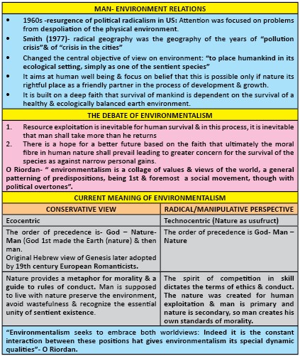
- Environmentalism approach to improve and protect the quality of the natural environment through changes to environmentally harmful anthropogenic activities- need effective environmental clearance with careful scientific assessment of the project.
Climate change impacts across the entire water cycle through increased variability in rainfall and streamflow and reduced rainfall in many dry regions. Therefore, better water management is crucial not only for sustainable development but also for food and nutrition security.
Global Impacts of Soil Erosion
Global Perspective on Soil Erosion:

Global impacts of Soil Erosion:
- Impact on agriculture: Soil erosion removes valuable top soil which is the most productive part of the soil profile for agricultural purposes. Thus, it decreases agricultural productivity which in turn a major threat to global food security and to the achievement of the Sustainable Development Goals (SDGs) –compromising the well-being of at least 3.2 billion people around the world.

- Aggravates climate change: Erosion degrades land, which means it can support fewer plants that can take in climate-warming carbon dioxide. Soils themselves could potentially sequester enough greenhouse gases in a year to equal about 5% of all annual human-made GHG emissions.
- Hydrological risks: The effects of soil erosion go beyond the loss of fertile land. It has led to increased pollution and sedimentation in streams and rivers, clogging these waterways and causing declines in fish and other species. And degraded lands are also often less able to hold onto water, which can worsen flooding. Also soil erosion can affect the infiltration, storage and drainage of water in the soil, resulting in waterlogging and water scarcity.

- Impact on biogeochemical cycling: soils play a key role in controlling the storage, transformation and flux of nutrients and carbon (C) through the lithosphere and biosphere. Agricultural soil erosion can result in lateral fluxes of nitrogen and phosphorus that are similar in magnitude to those induced by fertilizer application and crop removal. Furthermore, erosion-induced burial of soil reduces decomposition of soil organic carbon and could lead to long-term carbon storage, thereby altering the nutrient cycles.
- Socio-economic implications: Soil erosion and socio-economic interacts with each other. Soil erosion leads to food insecurity, water scarcity, causes non-point source pollution, degrades ecosystem functions, amplifies hydrogeological risk such as landslides or floods, causes damage to urban infrastructure and, in severe cases, leads to displacement of human populations.
- Impact on biodiversity:

Way forward:
- Because 95 percent of the food we eat comes from the soil, soil erosion mitigation through the application of Sustainable Soil Management (SSM) is critical for protecting our soil while ensuring a sustainable and food secure world.
- Soil friendly agricultural practices:
- Terrace farming need to be implemented to make hillside agriculture manageable. Terraces prevent erosion and allow more water to flow to crops. In addition, hillside farm fields need full crop cover to help keep the soil in place. This can be accomplished through intercropping.
- For smallholders, agroforestry systems where a diverse set of crops, including trees, are grown together can be effective.
- Prevention and rehabilitation: The key to managing and reducing soil erosion is to rehabilitate already-damaged land, stop further degradation and put erosion-preventive measures at the core of land management policy. In this way, we can also prevent hunger and mitigate the climate crisis.
- The Bonn Challenge: it is a global effort to bring 150 million hectares of degraded and deforested land into restoration by 2020 and 350 million by 2030, so as to reduce soil erosion and mitigate climate change.

Where it can be used?
It can be used in topics related to Paper 1 (Climate Change, Soil erosion, Degradation and conservation, World agriculture), Paper 2 (Agriculture, Environmental hazards, Pollution, Sustainable development) and GS 3 (Environmental degradation).
Sources:
Mission for Integrated Development of Horticulture (MIDH)
Mission for Integrated Development of Horticulture (MIDH) is a Centrally Sponsored Scheme for the holistic growth of the horticulture sector covering fruits, vegetables, root & tuber crops, mushrooms, spices, flowers, aromatic plants, coconut, cashew, cocoa and bamboo.
Objectives:
- Promote holistic growth of horticulture sector, through area based regionally differentiated strategies, which includes research, technology promotion, extension, post-harvest management, processing and marketing, in consonance with comparative advantage of each State/region and its diverse agro-climatic features;
- Encourage aggregation of farmers into farmer groups like FIGs/FPOs and FPCs to bring economy of scale and scope.
- Enhance horticulture production, augment farmers, income and strengthen nutritional security;
- Improve productivity by way of quality germplasm, planting material and water use efficiency through Micro Irrigation.
- Support skill development and create employment generation opportunities for rural youth in horticulture and post-harvest management, especially in the cold chain sector.

Mission for Integrated Development of Horticulture (MIDH)
Source:
Vog
Vog (volcanic smog) is a visible haze comprised of gas and an aerosol of tiny particles and acidic droplets created when sulfur dioxide (SO2) and other gases emitted from a volcano chemically interact with sunlight and atmospheric oxygen, moisture, and dust.

- The exact composition of vog depends on how much time the volcanic plume has had to react in the atmosphere. In areas far (tens to hundreds of km or miles) from active vents, aerosols are the main component of vog. Closer to the volcano, vog contains both aerosols and unreacted SO2 gas.
- Vog can affect areas far from the volcano, including the western side of the Big Island and even other islands. But lately, trade winds have been blowing most of the vog offshore.
- With trade winds, communities where lava fissures have opened and those downwind are the most affected.
- Health issues - physical complaints associated with vog exposure include headaches, breathing difficulties, increased susceptibility to respiratory ailments, watery eyes, sore throat, flu-like symptoms, and a general lack of energy.
- Tiny droplets of sulfuric acid in vog creates acid rain, which can leach lead from roofing and plumbing materials, such as nails, paint, solder, and metal flashings. Leached lead poses a health hazard when it contaminates drinking water in rooftop rainwater-catchment systems.
- The presence of vog reduces visibility, creating a potential hazard for drivers. Vog can also limit visibility for air and ocean traffic.
- Vog is a hazard that's associated with Hawaiian volcanoes in particular.

Image 1; Hawaii Volcano Releases Vog
Sources:
e-NAM Scheme
What is e-NAM? - It is an online transparent competitive bidding system that facilitates farmers with remunerative prices for their produce. Small Farmers Agribusiness Consortium (SFAC) is the lead agency for implementing eNAM.
It aims to promote uniformity in agriculture marketing by streamlining of procedures across the integrated markets, removing information asymmetry between buyers and sellers and promoting real time price discovery based on actual demand and supply.
So far, 1000 mandis of 18 States and 3 UTs have been integrated with e-NAM platform.

Advantages of e-NAM
- Unified market through online trading platform.
- It uses estimations based on actual demand and supply, promotes transparency in auction process
- Single point levy of market fee.
- Provision for electronic auction as a mode for price discovery.
Challenges faced by e-NAM?
- Convincing all the stakeholders like farmers, traders etc., move to the online platform.
- Scarcity of electricity, computers, internet facilities and a shortage of staff and sorting and quality testing facilities also remains a huge challenge for this scheme.
- Lack of awareness of the e-NAM scheme among the farmers prevents them from adopting the same.
Sources:
A Depoldered area for flood protection and nature: Hedwige and Prosper Polders, Belgium
- Background and Region involved: The Hedwige and Prosper Polders are low-lying areas of reclaimed land that are located just before the Scheldt estuary reaches Antwerp, Belgium.


- Challenges faced: Storm surges threaten the Flanders coast, including the city of Antwerp. The occurrence of storm surges in the North Sea has increased significantly since the 1950s, and sea-level rise is projected to further raise this threat in coming decades due to climate change.
- Project:
- The Hedwige-Prosper Polder project is part of the wider Sigma Plan. (The Sigma Plan is designed to reinforce dikes and quay walls, and open up areas that can flood to protect land along the Scheldt estuary.)
- The depoldering project aims to remove the outer defences of the two polders and reopen these areas to the tides.
- It involves moving dike protection inland to provide room for water during tidal surges.
- The new dikes constructed inland will provide flood protection for the low-lying hinterland, and a system of creeks will be dug in the polders to simulate the natural wetland.
- Potential Benefits:
- Flood protection.
- Improved water quality (the marshlands will contribute to the self-cleaning capacity of the estuary).
- An increase in natural wetland area and more recreational opportunities.
- Belgian integrated water management objectives (shipping accessibility and flood protection).
Places in the news
|
Katra
|
|
Bhiwani
|
|
Gandhi Sagar Dam
|
|
Umling La Pass
|
|
Gir National Park
|
|
Jagatsinghpur
|

Share the article
Get Latest Updates on Offers, Event dates, and free Mentorship sessions.


Get in touch with our Expert Academic Counsellors 👋
FAQs
Geography Current Affairs focuses on the contemporary issues, events, and developments in the field of geography. It covers recent geographical phenomena, environmental changes, geopolitical shifts, and related news. This differs from regular geography studies which may focus more on foundational concepts, historical contexts, and theoretical frameworks.
Updates are provided regularly to ensure that subscribers stay informed about the latest developments in geography. Typically, updates are provided on a fortnightly basis, depending on the frequency of significant events and changes in the field.
Absolutely. Geography Current Affairs serves as a valuable resource not only for Geography optional but also for GS papers, especially GS Paper 1 (covering Indian Heritage and Culture, History, and Geography of the World and Society) and GS Paper 3 (covering Technology, Economic Development, Biodiversity, Environment, Security, and Disaster Management). It aids in building a holistic understanding of various topics and strengthens answer-writing skills by incorporating contemporary examples and perspectives.
Geography Current Affairs holds immense importance for UPSC preparation, particularly for aspirants opting for Geography optional. It helps candidates stay updated with the latest developments, geographical phenomena, environmental issues, and geopolitical shifts worldwide, aligning them with the dynamic nature of the subject as tested in the UPSC examinations.