
24 May to 10 Jun, 2026
LOCALIZED CLIMATE GOVERNANCE
Why in news : India is witnessing a significant evolution in climate governance as states transition from generic, top-down State Action Plans on Climate Change (SAPCCs) to localized, data-driven strategies like the Urban Heat Island (UHI) mitigation efforts.
About :
Climate change is increasingly emerging as a local governance challenge rather than merely a global environmental concern. India has witnessed a sharp rise in climate-induced risks such as heatwaves, urban flooding, water scarcity, and air pollution, particularly in rapidly growing cities. Between 1901 and 2023, India's average temperature increased by nearly 0.7°C, while several cities recorded temperatures above 48°C in recent years. Urban areas often experience temperatures 3–8°C higher than surrounding rural regions due to the Urban Heat Island (UHI) effect, exacerbating health and productivity losses. Traditionally, climate action was guided by broad State Action Plans on Climate Change (SAPCCs), which adopted a state-wide approach. However, the uneven spatial distribution of climate impacts has highlighted the need for localized, data-driven interventions. Consequently, India is transitioning towards city-specific climate governance, exemplified by Urban Heat Island mitigation and climate-resilient urban planning initiatives.
Evolution of Climate Governance in India
A. First Generation Climate Governance
India's initial climate governance architecture was largely top-down and sector-oriented, focusing on integrating climate concerns into state and national development planning.
- National Action Plan on Climate Change (NAPCC), 2008: Established eight national missions covering solar energy, water conservation, sustainable agriculture, energy efficiency, and ecosystem protection.
- State Action Plans on Climate Change (SAPCCs): States prepared climate strategies aligned with local vulnerabilities and development priorities.
Sectoral Focus
- Agriculture: Climate-resilient crops, drought management (e.g., promotion of millets in Rajasthan).
- Water: Watershed development and groundwater conservation (e.g., Jalyukt Shivar in Maharashtra).
- Energy: Expansion of renewable energy capacity (e.g., Gujarat's solar parks).
- Forestry: Afforestation and carbon sink creation (e.g., Green India Mission).
- Disaster Management: Cyclone preparedness and early warning systems (e.g., Odisha's cyclone management model).
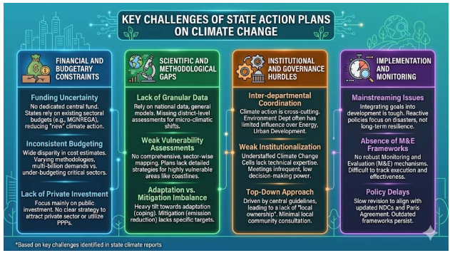
B. Limitations of SAPCCs
While SAPCCs mainstreamed climate concerns, several implementation gaps emerged:
- Broad and generic recommendations: Similar strategies were adopted across states despite differing local conditions.
- Limited city-level implementation: Urban-specific risks often remained outside planning frameworks.
- Weak local data integration: Lack of ward-level climate vulnerability assessments.
- Insufficient monitoring mechanisms: Difficulty in tracking outcomes and measuring effectiveness.
- Neglect of urban climate risks: Issues such as Urban Heat Islands, urban flooding, and heat stress received limited attention.
Example: Despite having SAPCCs, cities like Delhi, Ahmedabad, and Hyderabad experienced recurrent heatwaves and localized climate stresses, prompting the development of dedicated Heat Action Plans and city-specific climate strategies beyond traditional state-level frameworks.
Why is Localized Climate Governance Emerging?
A. Growing Urban Vulnerability
1. Urban Heat Waves
- Indian cities are experiencing more frequent and prolonged heatwaves due to climate change and Urban Heat Island effects.
- Heatwaves have become one of India's deadliest weather hazards, affecting public health and urban livability.
Example: In May 2024, Delhi recorded temperatures above 49°C, while parts of Rajasthan crossed 50°C, causing severe heat stress and disruptions to daily life.
2. Rapid Urbanization
- Expansion of roads, buildings, and paved surfaces increases heat absorption and reduces natural cooling.
- Urban growth often occurs at the expense of green spaces, water bodies, and wetlands.
Example: Bengaluru lost a significant proportion of its lakes and green cover over recent decades, contributing to rising urban temperatures and flooding incidents.
3. Climate Justice Concerns
- Climate impacts are not evenly distributed; low-income groups face greater exposure and lower adaptive capacity.
- Slum residents, street vendors, construction workers, delivery personnel, and the elderly are particularly vulnerable.
Example: During extreme heat events, outdoor workers in cities such as Ahmedabad and Delhi face reduced working hours, income losses, and higher health risks.
4. Rising Economic Costs
- Extreme heat lowers labour productivity, increases electricity demand, and raises healthcare expenditures.
- Urban economies become increasingly vulnerable to climate-induced disruptions.
Example: According to estimates by the International Labour Organization (ILO), heat stress could lead to the loss of millions of working hours annually in India, particularly in construction and agricultural sectors. Simultaneously, electricity demand in major cities spikes sharply during heatwaves due to increased air-conditioning and cooling needs.
Urban Heat Island (UHI): A New Frontier in Climate Governance
What is Urban Heat Island (UHI)?
Urban Heat Island (UHI) refers to the phenomenon whereby urban areas record significantly higher temperatures than their surrounding rural regions. This occurs because cities replace natural landscapes with heat-absorbing surfaces and generate large amounts of waste heat.
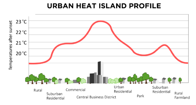
Key Drivers
- Concrete structures and buildings absorb and retain solar heat during the day and release it slowly at night.
- Asphalt roads can attain surface temperatures exceeding 50–60°C during summer.
- Reduced vegetation lowers evapotranspiration, diminishing the natural cooling effect.
- Anthropogenic heat emissions from vehicles, industries, air-conditioners, and power consumption further elevate urban temperatures.
Example: Studies in Delhi, Hyderabad, and Ahmedabad have documented urban temperatures 3–8°C higher than nearby rural areas during peak summer conditions.
Features of New-Age Climate Governance
Unlike earlier climate policies that relied on broad state-level assessments, the new generation of climate governance is localized, technology-enabled, and implementation-oriented, focusing on micro-level vulnerabilities and targeted interventions.
1. Data-Driven Planning
Climate decisions are increasingly guided by high-resolution spatial and climatic data rather than generalized projections.
- Satellite imagery, GIS mapping, and remote sensing help identify heat hotspots, flood-prone zones, and shrinking green spaces.
- Hyper-local temperature monitoring enables city authorities to target the most vulnerable neighbourhoods.
Example: Ahmedabad and Delhi have used satellite-based heat mapping to identify areas experiencing severe Urban Heat Island effects. Under the Smart Cities Mission, GIS platforms are increasingly being integrated into urban planning.
2. Decentralized Governance
Climate action is shifting from state governments to city administrations and local institutions that better understand local risks.
- Municipal corporations and Urban Local Bodies (ULBs) are becoming key actors in climate adaptation.
- Ward-level planning allows interventions tailored to neighbourhood-specific vulnerabilities.
Example: Ahmedabad Municipal Corporation pioneered India's first Heat Action Plan (2013), demonstrating how city-level institutions can lead climate adaptation measures.
3. Evidence-Based Interventions
Policies are now based on scientific assessments rather than broad assumptions.
- Heat mapping identifies high-temperature zones.
- Vulnerability assessments locate populations most at risk.
- Risk zoning guides infrastructure and land-use decisions.
Example: Telangana's cool-roof initiatives targeted low-income settlements identified through vulnerability assessments, helping reduce indoor temperatures by approximately 2–5°C.
4. Integration Across Sectors
Climate governance is increasingly embedded within urban development and public service delivery.
- Urban Planning: Expansion of green spaces and climate-resilient infrastructure.
- Public Health: Heat warning systems and cooling centres.
- Water Management: Restoration of urban lakes and wetlands.
- Energy Efficiency: Promotion of cool roofs and energy-efficient buildings.
Example: Hyderabad's Heat Action Plan combines public health advisories, urban greening, water access measures, and heat-risk monitoring, illustrating a multi-sectoral approach to climate resilience.
Case Study: Ahmedabad Heat Action Plan (AHAP) – A Pioneer in Localized Climate Governance
The Ahmedabad Heat Action Plan (AHAP), launched in 2013, is widely regarded as South Asia's first city-level Heat Action Plan and a landmark example of localized climate governance. It was developed following the devastating 2010 heatwave, during which Ahmedabad experienced temperatures exceeding 46°C, leading to a significant rise in heat-related illnesses and deaths.
Key Interventions
- Early Warning System: Collaboration between the India Meteorological Department (IMD) and city authorities to issue heat alerts several days in advance.
- Public Awareness Campaigns: Dissemination of heat-safety guidelines through SMS, media, schools, and community outreach.
- Healthcare Preparedness: Training of doctors and hospital staff to identify and treat heat-related illnesses.
- Protection of Vulnerable Groups: Special focus on outdoor workers, slum residents, children, and the elderly.
Outcomes
- Studies indicate that the plan contributed to a substantial reduction in heat-related mortality, particularly during extreme heat events.
- The Ahmedabad model has inspired similar Heat Action Plans in more than 20 Indian states and numerous cities, including Delhi, Bhubaneswar, Nagpur, and Hyderabad.
Challenges in the Transition to Localized Climate Governance
1. Institutional Challenges
Despite growing climate risks, many Urban Local Bodies (ULBs) lack the technical expertise, manpower, and institutional capacity needed for climate planning and implementation.
- Climate governance often remains an additional responsibility rather than a dedicated function.
- Coordination between municipal bodies, development authorities, state departments, and disaster management agencies remains weak.
Example: Many Indian cities still lack dedicated climate cells, making implementation of Heat Action Plans and resilience projects dependent on external agencies and consultants.
2. Financial Constraints
Localized climate adaptation requires substantial investments in green infrastructure, cooling systems, urban forests, and climate-resilient services.
- Most ULBs have limited own-source revenues.
- Climate projects largely depend on state government support, central schemes, or international funding.
Fact: Municipal bodies in India account for only a small share of total public expenditure compared to cities in developed countries, constraining their ability to undertake large-scale climate interventions.
Example: Projects such as urban wetland restoration and cool-roof programmes often rely on Smart Cities Mission or externally funded initiatives rather than municipal budgets.
3. Data Challenges
Effective localized governance depends on accurate and granular climate information, which remains inadequate in many cities.
- Lack of ward-level climate and vulnerability data.
- Multiple agencies maintain separate datasets, resulting in fragmented information systems.
Example: While cities like Ahmedabad and Delhi have developed heat-vulnerability maps, many Tier-II and Tier-III cities still lack high-resolution temperature, flood-risk, and exposure databases required for evidence-based planning.
4. Governance Challenges
Climate concerns are often poorly integrated into urban development decisions.
- Master Plans frequently prioritize infrastructure expansion without adequately accounting for climate risks.
- Political leadership tends to focus on projects with immediate visible outcomes, whereas climate adaptation yields benefits over longer periods.
Example: Continued construction on urban floodplains and wetland areas in cities such as Bengaluru and Chennai has increased vulnerability to flooding despite repeated climate-related disasters.
Future Roadmap for Localized Climate Governance
1. Institutionalize Urban Climate Cells
Dedicated climate units should be established within municipal corporations for planning, monitoring, and coordination.
Example: Several Smart Cities have begun setting up climate and sustainability offices, but wider institutionalization remains necessary.
2. Mainstream Climate Considerations into Master Plans
Urban development plans should integrate heat, flood, and water-risk assessments before approving infrastructure projects.
Example: Chennai's post-2015 flood planning increasingly emphasizes floodplain protection and climate-sensitive urban development.
3. Strengthen Municipal Finances
Cities require predictable financial resources to invest in resilience infrastructure.
Fact: Urban India may require hundreds of billions of dollars in climate-resilient infrastructure investments by mid-century, far exceeding current municipal capacities.
4. Expand Green-Blue Infrastructure
Protecting and restoring parks, urban forests, lakes, rivers, and wetlands can simultaneously address heat, flooding, and biodiversity loss.
Example: Restoration of urban lakes in Bengaluru and wetland conservation initiatives in Kolkata have demonstrated multiple climate resilience benefits.
5. Develop Local Climate Data Repositories
Cities should establish integrated databases combining climate, health, infrastructure, and socioeconomic information for evidence-based decision-making.
Example: Ahmedabad's heat-risk mapping and IMD-supported early warning systems illustrate how localized datasets can improve climate preparedness.
Where to use:
Paper III ( General Studies ) : Climate and sustainability
SEMI CONDUCTOR MISSION
Why in news: Under the India Semiconductor Mission (ISM) 1.0, the Union Cabinet approved two semiconductor projects in Gujarat, including India’s 1st commercial GaN-based Mini/Micro-LED display facility and a semiconductor packaging unit.
About:
Introduction
Semiconductors are the foundational building blocks of the digital economy, powering smartphones, computers, automobiles, defence systems, Artificial Intelligence (AI), 5G networks, and advanced manufacturing. Often called the "new oil of the digital age", semiconductors have become central to economic competitiveness, technological leadership, and national security.
Facts & Data
- Global semiconductor market expected to reach USD 681 billion (2024).
- More than 92% of advanced chips are manufactured in Taiwan.
- India's semiconductor market stood at approximately USD 34 billion in 2023 and is projected to grow rapidly with digitalisation.
Location Factors of Semiconductor Industry
The semiconductor industry represents one of the best examples of high-technology industrial location theory, where knowledge, infrastructure, geopolitics, and supply chains matter more than raw materials.
A. Availability of Skilled Human Capital
Semiconductor manufacturing requires highly trained engineers, physicists, material scientists, and chip designers.
Example
- South Korea's semiconductor cluster around Seoul benefits from a highly skilled workforce.
- India possesses nearly 20% of the world's semiconductor design engineers.
Geographic Insight
Knowledge-intensive industries exhibit strong agglomeration economies around universities and research institutions.
B. Strong Research and Innovation Ecosystem
Continuous innovation is necessary due to rapid technological obsolescence.
Example
- Silicon Valley (USA)
- Hsinchu Science Park (Taiwan)
- Eindhoven Cluster (Netherlands)
Fact
TSMC spends billions of dollars annually on R&D to maintain technological leadership.
C. Government Support and Industrial Policy
Semiconductor fabrication plants (fabs) require enormous capital investment.
Example
- Taiwan's Industrial Technology Research Institute (ITRI) laid the foundation for TSMC.
- USA's CHIPS Act allocates over USD 52 billion to strengthen domestic chip manufacturing.
- India's Semiconductor Mission offers incentives worth ₹76,000 crore.
Geographic Significance
Government intervention often determines the emergence of semiconductor clusters.
D. Reliable Infrastructure
Semiconductor fabrication requires:
- Continuous electricity supply
- Ultra-pure water
- Advanced logistics
- High-speed digital connectivity
Example
- Taiwan's fabs consume enormous quantities of ultra-pure water.
- Germany's advanced infrastructure supports automotive semiconductor production.
Fact
A single advanced fab may consume millions of litres of water daily.
E. Supply Chain Connectivity
The industry operates through globally dispersed production networks.
Example
- Design: USA
- Manufacturing Equipment: Netherlands
- Fabrication: Taiwan
- Assembly: Southeast Asia
Geographic Insight
Modern semiconductor production exemplifies Global Production Networks (GPNs).
F. Market Access
Proximity to major electronics manufacturing centres reduces logistics costs.
Example
- Chinese semiconductor firms benefit from proximity to the world's largest electronics manufacturing ecosystem.
Fact
China remains the world's largest consumer of semiconductors.
G. Intellectual Property (IP) Protection
Strong IP laws attract investments in advanced technologies.
Example
- USA, Taiwan, Switzerland and South Korea have strong patent protection systems.
Geographic Relevance
Knowledge-intensive industries prefer politically stable regions with strong legal institutions.
H. Geopolitical Stability
Semiconductors have become strategic assets.
Example
- US-China technological rivalry.
- Global concern over Taiwan Strait tensions.
Impact
Location decisions increasingly incorporate geopolitical risks.
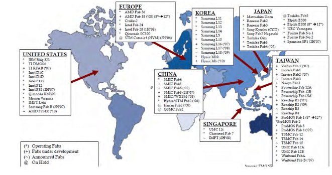
Taiwan: The World's Semiconductor Powerhouse (Case Study)
Taiwan produces more than 60% of global semiconductor foundry output and over 90% of advanced chips.
Why Taiwan Succeeded?
Early State Intervention
Government investment began during the 1970s.
Establishment of TSMC
TSMC pioneered the "pure-play foundry model."
Cluster Development
Hsinchu Science Park integrated:
- Universities
- Research institutes
- Manufacturers
Continuous Innovation
Leadership in 5 nm and 3 nm chip technologies.
Challenges Facing the Global Semiconductor Industry
Supply Chain Vulnerabilities
- COVID-19 disruptions
- Shipping bottlenecks
Raw Material Dependencies
|
Material |
Major Supplier |
|
Palladium |
Russia |
|
Neon Gas |
Ukraine |
Geopolitical Tensions
US-China technology restrictions have intensified competition.
Water and Energy Constraints
Semiconductor fabs are highly resource-intensive.
Conclusion
The semiconductor industry has evolved from a high-technology manufacturing sector into a strategic geopolitical asset. Its spatial distribution reflects the interaction of skilled labour, innovation ecosystems, infrastructure, state support, and global production networks. For India, the ongoing restructuring of global semiconductor supply chains presents a historic opportunity to emerge as a major node in the global semiconductor geography.
Where to use :
Paper II ( Geography Optional ) : Industries
SOLAR STORMS
Why in news : While most of India is unlikely to witness bright auroras, people in Ladakh, Jammu & Kashmir, and other high altitude northern regions have seen it.
About:
What are Solar Storms?
Solar storms are disturbances in space caused by intense activity on the Sun, leading to the release of enormous amounts of energy, radiation, and charged particles into space. They are a major component of space weather and can influence Earth's atmosphere, satellites, communication systems, navigation networks, and power grids.
Why Do Solar Storms Occur?
The Sun is composed of hot plasma and possesses a highly dynamic magnetic field. Twisting, tangling, and reconnection of magnetic field lines release massive amounts of energy, generating solar storms.
Main Sources
- Sunspots
- Magnetic reconnection
- Solar magnetic cycles (approximately 11 years)
Example: Solar activity generally peaks during the Solar Maximum, the most active phase of the Sun's 11-year cycle.
Types of Solar Storms
1. Solar Flares
Sudden bursts of electromagnetic radiation from the Sun's surface.
Characteristics
- Travel at the speed of light.
- Reach Earth within about 8 minutes.
- Affect radio communications and GPS systems.
Example
In May 2024, powerful X-class solar flares disrupted high-frequency radio communications in some regions.
2. Coronal Mass Ejections (CMEs)
Massive clouds of plasma and magnetic fields ejected from the Sun.
Characteristics
- Travel at 250–3000 km/s.
- Take 1–3 days to reach Earth.
- Can trigger geomagnetic storms.
Example
The 1859 Carrington Event remains the strongest recorded CME impact on Earth.
3. Solar Energetic Particle (SEP) Events
Streams of highly energetic protons and ions accelerated by solar eruptions.
Impacts
- Radiation hazard for astronauts.
- Risk to aircraft flying polar routes.
- Satellite damage.
Example
Airlines sometimes alter polar flight paths during intense SEP events.
4. Geomagnetic Storms
Occur when solar particles interact with Earth's magnetosphere.
Effects
- Auroras
- Power grid disturbances
- Satellite anomalies
Example
The March 1989 geomagnetic storm caused a province-wide blackout in Quebec.
Visibility of Solar Storms
Solar storms themselves are invisible, but their effects can be seen through auroras.
Aurora Borealis (Northern Lights)

Visible in:
- Norway
- Iceland
- Canada
- Finland
- Alaska

Aurora Australis (Southern Lights)
Visible in:
- New Zealand
- Australia
- Antarctica
Solar Storms and India
India is becoming increasingly vulnerable because of:
- Expanding satellite constellation programmes.
- Growth of digital infrastructure.
- Dependence on GNSS navigation.
- Human spaceflight missions such as Gaganyaan.
Solar storms are invisible cosmic hazards that transform activity on the Sun into tangible economic, technological, and geopolitical impacts on Earth, making space weather forecasting as important in the 21st century as terrestrial weather forecasting.
Where to use
Paper I ( Geography Optional ) : Solar storms
Coal gasification
Coal gasification: Coal gasification is a process in which coal is converted into a combustible gas mixture called syngas (mainly carbon monoxide, hydrogen, and methane) by reacting it with oxygen, steam, or air under high temperatures and controlled conditions. Syngas can be used for electricity generation, production of fertilizers, chemicals, methanol, and hydrogen. It is considered a cleaner alternative to direct coal combustion because pollutants can be removed before utilization, although it still involves significant carbon emissions unless coupled with carbon capture technologies.
Flue gas desulphurisation_10 June 2026
Flue gas desulphurisation: Flue Gas Desulphurisation (FGD) is a pollution-control technology used in thermal power plants and industries to remove sulphur dioxide (SO₂) from exhaust gases before their release into the atmosphere. The most common method uses limestone or lime slurry, which reacts with SO₂ to produce gypsum. FGD helps reduce acid rain, respiratory illnesses, and environmental degradation. In India, installation of FGD systems has become important for coal-based power plants to meet stricter emission standards and improve air quality.
Common But differentiated Responsibilities
Common But differentiated Responsibilities: Common But Differentiated Responsibilities (CBDR) is a principle of international environmental law recognized in the 1992 United Nations Conference on Environment and Development. It states that all countries share responsibility for addressing global environmental problems, but developed countries should bear a greater burden because of their historical contribution to environmental degradation and their greater financial and technological capabilities. CBDR forms a key foundation of global climate negotiations, including the Paris Agreement.
Exfiltration
Exfiltration: Exfiltration refers to the unauthorized transfer or extraction of sensitive data from a computer system, network, or organization by cybercriminals, insiders, or malware. It is often the final stage of a cyberattack after gaining access to a system. Stolen information may include personal records, financial data, intellectual property, or government secrets. Exfiltration can occur through emails, cloud services, removable devices, or encrypted channels. Preventive measures include encryption, access controls, network monitoring, and robust cybersecurity frameworks.
Isostatic Rebound
Isostatic Rebound: Isostatic rebound, also called post-glacial rebound, is the gradual rise of Earth's crust after the removal of a heavy load such as a massive ice sheet. During glacial periods, the weight of ice depresses the lithosphere into the underlying mantle. When the ice melts, the crust slowly uplifts to regain equilibrium according to the principle of isostasy. This process continues for thousands of years and is evident in regions such as Canada and Sweden, where land is still rising following the last Ice Age.
Terrain-Based Planning and Applied Geomorphology
The Konkan Railway (760 km), connecting Maharashtra, Goa, and Karnataka, is a classic example of applied geomorphology in infrastructure planning. The route traverses the rugged Western Ghats, characterized by steep slopes, lateritic plateaus, deeply incised valleys, and landslide-prone terrain. Detailed geomorphological mapping was used to identify stable rock formations, slope gradients, drainage patterns, and areas susceptible to mass wasting.
As a result, engineers constructed 92 tunnels and over 2,000 bridges, avoiding highly unstable landforms. Slope stabilization measures, rock bolting, and improved drainage systems were incorporated to reduce landslide risks. The project significantly improved connectivity along India's western coast while minimizing geomorphic hazards.
The Konkan Railway demonstrates how geomorphological knowledge can enhance the safety, sustainability, and economic viability of large-scale infrastructure projects in complex terrains.

Where to use:
Paper I ( Geography Optional ) : Geomorphology
Places in News - 10 June 2026
1. Dhar
Why in news: The Madhya Pradesh High Court declared the disputed Bhojshala-Kamal Maula Mosque complex in Dhar district as a temple dedicated to Goddess Vagdevi (Saraswati). The court quashed a 2003 Archaeological Survey of India (ASI) order that had allowed shared worship by Hindus and Muslims at the site.
About:
- It is situated on the northern slopes of the Vindhya Range and commands one of the gaps leading to the Narmada River valley to the south.
- Physiographically, the district is traversed by the Vindhyan ranges and forms part of the watersheds of the Narmada, Chambal, and Mahi river systems.
- The combination of black cotton soil and the Narmada alluvial plains makes the region highly agricultural. Major crops include soybean, wheat, maize, pulses, and sugarcane.
2. Thoothukudi
Why in news: India signed a landmark Memorandum of Understanding (MoU) for the development of its first Mega Greenfield Shipyard at Thoothukudi, Tamil Nadu, marking a major step towards achieving the Maritime Amrit Kaal Vision 2047 and strengthening the country’s global shipbuilding ambitions.
About:
- It is a port industrial city in Thoothukudi district in the Indian state of Tamil Nadu.
- Thoothukudi is a port town situated in the Gulf of Mannar, about 125 km (78 mi) north of KanyaKumari
- It lies on the Coromandel Coast of the Bay of Bengal.
- Thoothukudi has the second highest Human Development Index in Tamil Nadu, next to Chennai.
- Known as "Pearl City" due to the pearl fishing carried out in the town.
3. Havelock Island
Why in news: The Andaman and Nicobar Islands recently hosted two unique underwater world records at Swaraj Dweep (Havelock Island) to promote eco-tourism and establish the islands as a prime adventure destination.
About:
- It is part of Ritchie’s Archipelago, in India’s Andaman Islands.
- It’s known for its dive sites and beaches, like Elephant Beach, with its coral reefs.
- Crescent-shaped Radhanagar Beach is a popular spot for watching the sunset. On the island’s east side, rocky sections mark long, tree-lined Vijaynagar Beach.
- It was renamed, by Prime Minister Narendra Modi, as Swaraj Dweep as a tribute to Subhas Chandra Bose.
4. Nahargarh Biological Park
Why in news: Rajasthan High Court recently set aside a National Board for Wildlife panel decision that denied wildlife clearance to Taj Amber, a five-star property located about 97 metres from the Nahargarh Wildlife Sanctuary boundary.
About:
- Located roughly 12 km from Jaipur, it lies within the Nahargarh Wildlife Sanctuary (WLS) and is nestled in the Aravalli range.
- It hosts over 285 species of birds. Its most notable avian species is the white-naped tit, found exclusively in this region.
- Ram Sagar lake serves as a prominent location for ornithologists and bird enthusiasts.
5. Paatalkot Valley
Why in news: Patalkot, often hailed as a ‘monsoon travel hotspot,’ is facing the water crisis.
About:
- Patalkot Valley is a stunning, horseshoe-shaped gorge in the Satpura ranges of Madhya Pradesh, India.
- Doodhi river (tributary of River Narmada) flows in the valley.
- It is home to Gond and Bharia tribes, classified as Particularly Vulnerable Tribal Groups (PVTGs).

Fortnightly KOSMOS MCQs Practice - 10th June 2026
Q1. Consider the following statements regarding the concept of Ecological Niche:
1. An ecological niche is not just the physical space occupied by an organism, but its functional role and position within an ecosystem.
2. The Fundamental Niche of a species is usually broader than its Realized Niche because it represents the full potential range of physical conditions under which it can survive without biological competition.
3. According to Gause’s Principle of Competitive Exclusion, two species with identical ecological niches cannot coexist indefinitely in the same habitat when resources are limiting.
4. Niche Differentiation allows competing species to coexist by altering their behavior, feeding times, or structural adaptations.
According to the latest ecological classifications, how many of the above statements are correct?
- Only one
- Only two
- Only three
- All four
Q2. Consider the following :
Statement-I: Two closely related species competing for the exact same limiting resources can coexist in a stable environment over long evolutionary timescales.
Statement-II: Natural selection drives niche displacement, forcing species to adapt to slightly different ecological roles or micro-habitats to minimize direct competitive stress.
Which one of the following is correct in respect of the above statements?
- Both Statement-I and Statement-II are correct and Statement-II is the correct explanation for Statement-I.
- Both Statement-I and Statement-II are correct but Statement-II is NOT the correct explanation for Statement-I.
- Statement-I is correct but Statement-II is incorrect.
- Statement-I is incorrect but Statement-II is correct.
Q3. Consider the following pairs of Ecological Terms and their operational definitions:
1. Ecotope: The specific physical geographical zone inhabited by a singular population or community.
2. Guild: A group of distinct species that exploit the same class of environmental resources in a similar way, regardless of taxonomic relationship.
3. Ecotone: A zone of gradual transition between two or more distinct ecological communities where edge effects are prominent.
4. Ecological Equivalent: Unrelated species that occupy highly similar niches in different geographical regions due to convergent evolution.
In how many of the above rows is the information correctly matched?
- Only one
- Only two
- Only three
- All four
Q4. With reference to global warming and its impact on species distribution, consider the following statements:
1. Climate change causes a mismatch between a species' realized niche and its geographic location, forcing upward or poleward range shifts.
2. Niche Conservatism refers to the tendency of species to retain their ancestral ecological niches over time, making them highly vulnerable to rapid habitat fragmentation.
3. Generalist species with broad ecological niches are typically the first to face extinction during sudden climate shifts compared to highly specialized endemic species.
Which of the statements given above are correct?
- 1 and 2 only
- 2 and 3 only
- 1 and 3 only
- 1, 2, and 3
Q5. Consider the following statements regarding niche space and ecosystem stability:
1. A Keystone Species operates within a unique niche that exerts a disproportionate biotic control on the structure of the entire community relative to its abundance.
2. The concept of Niche Breadth indicates how evenly or widely a species distributes its resource utilization across available environmental gradients.
3. Invasive alien species often succeed in a new habitat by occupying a "Vacant Niche" that lacks native competitors or efficient natural predators.
How many of the above statements are correct?
- Only one
- Only two
- All three
- None
Q6. Consider the following statements regarding the structural and functional organization across ecological levels:
1. At the Organismal level, physiological and behavioral adaptations determine how an individual response to abiotic stresses like thermoregulation and osmoregulation.
2. A Population is characterized by emergent properties, such as birth rate, death rate, and sex ratio, which are absent at the individual organismal level.
3. The Biosphere represents the global sum of all ecosystems, functioning as a completely closed thermodynamic system with respect to both energy and matter.
How many of the above statements are correct?
- Only one
- Only two
- All three
- None
Q7. Consider the following :
Statement-I: Ecological Communities possess functional attributes such as species richness, dominance, and trophic structure that cannot be predicted merely by analyzing the individual populations that comprise them.
Statement-II: An Ecosystem integrates the biotic community with its physical abiotic environment through unidirectional energy flows and cyclical nutrient processes.
Which one of the following is correct in respect of the above statements?
- Both Statement-I and Statement-II are correct and Statement-II is the correct explanation for Statement-I.
- Both Statement-I and Statement-II are correct and Statement-II is NOT the correct explanation for Statement-I.
- Statement-I is correct but Statement-II is incorrect.
- Statement-I is incorrect but Statement-II is correct.
Q8. When scaling from regional landscapes to global patterns, ecological boundaries become macro-structures. Consider the following pairs of Ecological Levels and their characteristic parameters:
1. Landscape: A heterogeneous geographic area characterized by a mosaic of interacting ecosystems.
2. Biome: A large regional unit characterized by major vegetation types and associated fauna, determined primarily by regional climate patterns.
3. Ecotone: A structural boundary layer marking the absolute, non-overlapping physical endpoint where one biome terminates and another begins.
In how many of the above rows is the information correctly matched?
- Only one row
- Only two rows
- All three rows
- None of the rows
Q9. Consider the following pairs of Ecotones and their primary environmental drivers:
1. Mangrove Swamps: Marine-Terrestrial interface driven by tidal salinity gradients.
2. Estuaries: Freshwater-Saltwater interface driven purely by temperature inversions.
3. Alpine Timberline: Forest-Tundra interface driven exclusively by tectonic plate margins.
How many of the above pairs are correctly matched?
- Only one
- Only two
- All three
- None
Q10. Consider the following pairs of Abiotic Factors and their direct Ecophysiological Impacts:
1. Temperature: Influences the kinetics of enzymes and sets the thermal tolerance limits for organisms.
2. Light Intensity: Dictates the rate of photoperiodism and primary productivity in producers.
3. Soil pH: Directly regulates the chemical availability of essential mineral nutrients to plant roots.
How many of the above pairs are correctly matched?
- Only one
- Only two
- All three
- None
Share the article
Get Latest Updates on Offers, Event dates, and free Mentorship sessions.


Get in touch with our Expert Academic Counsellors 👋
FAQs
Geography Current Affairs focuses on the contemporary issues, events, and developments in the field of geography. It covers recent geographical phenomena, environmental changes, geopolitical shifts, and related news. This differs from regular geography studies which may focus more on foundational concepts, historical contexts, and theoretical frameworks.
Updates are provided regularly to ensure that subscribers stay informed about the latest developments in geography. Typically, updates are provided on a fortnightly basis, depending on the frequency of significant events and changes in the field.
Absolutely. Geography Current Affairs serves as a valuable resource not only for Geography optional but also for GS papers, especially GS Paper 1 (covering Indian Heritage and Culture, History, and Geography of the World and Society) and GS Paper 3 (covering Technology, Economic Development, Biodiversity, Environment, Security, and Disaster Management). It aids in building a holistic understanding of various topics and strengthens answer-writing skills by incorporating contemporary examples and perspectives.
Geography Current Affairs holds immense importance for UPSC preparation, particularly for aspirants opting for Geography optional. It helps candidates stay updated with the latest developments, geographical phenomena, environmental issues, and geopolitical shifts worldwide, aligning them with the dynamic nature of the subject as tested in the UPSC examinations.