
10 Oct to 24 Oct, 2025
AIR POLLUTION IN NORTH WEST INDIA
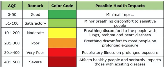
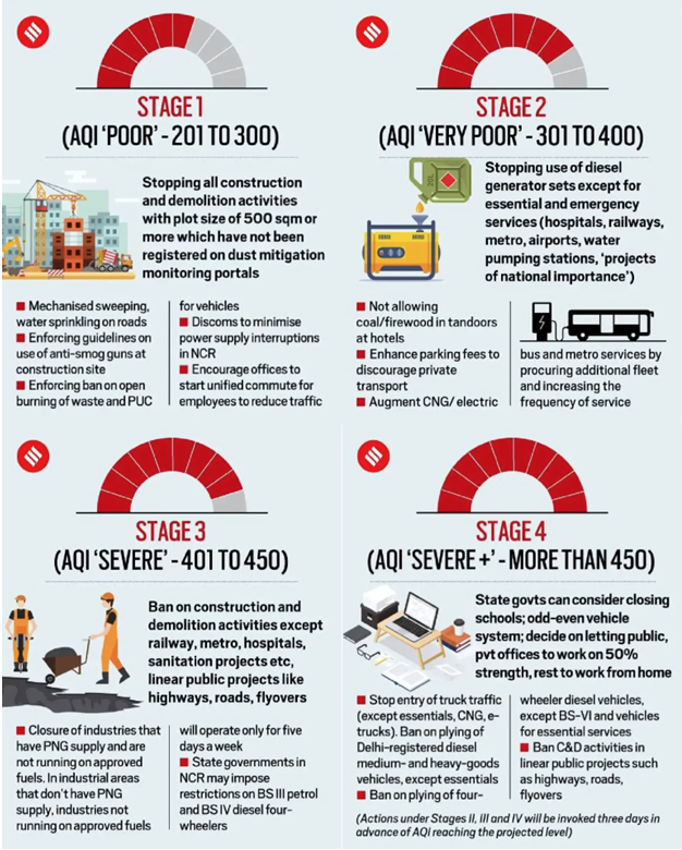
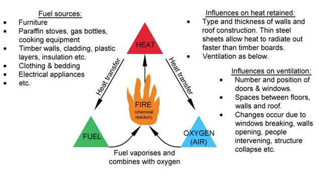
Why in news : CAQM Sub-Committee on GRAP has directed to enforce measures outlined under Stage II due to deterioration in NCR’s air quality index (AQI).
About :
- India’s Graded Response Action Plan (GRAP) is conceptually inspired by international air quality management frameworks, particularly from China and the United States, where tiered or graded pollution response systems already existed before GRAP’s formulation in 2016.
Why India’s GRAP Is Unique
While conceptually influenced, GRAP is contextually Indianized to suit:
- Topographical realities (Indo-Gangetic Basin trapping pollutants).
- Socio-economic constraints (large informal construction sector).
- Federal governance complexity (multi-state NCR structure).
Major Reasons for Air Pollution in Northwest India
A. Agricultural Residue (Stubble) Burning
- Post-harvest burning of paddy straw in Punjab and Haryana (Oct–Nov) releases huge quantities of PM₂.₅, CO₂, and black carbon.
- Contributes up to 40% of Delhi’s winter PM₂.₅ (SAFAR–MoES data, 2023).
B. Vehicular Emissions
- Delhi NCR has ~13 million registered vehicles (2024), among the highest globally.
- Congested traffic, idling at signals, and diesel-heavy public transport worsen NOx and PM emissions.
- Vehicular exhaust contributes ~25–30% of PM₂.₅ in Delhi’s air.
C. Industrial and Thermal Power Plant Emissions
- Concentration of thermal power plants (Dadri, Panipat, Bathinda) and small-scale industries (metal casting, brick kilns, textiles) around NCR.
Example: Panipat’s industrial cluster contributes 7–10% of Haryana’s total SO₂ load (CPCB, 2022).
D. Construction and Road Dust
- Rapid urbanization and infrastructure projects generate fugitive dust, accounting for ~35% of total PM₁₀ in Delhi NCR.
Geographical cause: Arid winds from Rajasthan’s Thar region transport dust particles eastwards, compounding urban emissions.
E. Geographical and Meteorological Factors
- Topography of the Indo-Gangetic Basin (IGB):
- Surrounded by the Himalayas in the north → prevents pollutant dispersion.Flat plains cause pollutant stagnation.
- Winter temperature inversion: Cold air traps pollutants near the surface.
- Low wind speed and fog formation reduce vertical mixing of air.
Challenges in GRAP
- Reactive Rather Than Preventive Approach: GRAP activates measures after air quality worsens — it is reactive, not preventive.By the time Stage III or IV is triggered, the atmospheric boundary layer has already trapped pollutants.Example:Winter 2023 saw PM₂.₅ levels crossing 400 µg/m³ within 48 hours before GRAP Stage IV kicked in — too late for preventive mitigation.
- Use AI-based forecasting models (e.g., IITM’s SAFAR) for predictive triggers.
- Limited Integration with Urban Planning: GRAP treats air pollution as a seasonal crisis, not as part of urban form and function. Issues like urban sprawl, vehicular congestion corridors, and construction dust are structural — not temporary.Example: Dust emissions from NCR’s radial highways (NH-48, NH-9) persist year-round but are only addressed under emergency stages.
- No Integration with Long-Term Climate Strategy: GRAP acts as a standalone seasonal policy, not aligned with India’s National Clean Air Programme (NCAP) or State Action Plans on Climate Change (SAPCCs).
System Thinking – GRAP as a “Feedback Mechanism”
System thinking, rooted in General Systems Theory (Ludwig von Bertalanffy, 1968), treats the environment as a complex dynamic system of inputs, processes, outputs, and feedback loops. Geography and environmental management borrow this idea to explain how human actions interact with natural processes.
Application to GRAP:
The Graded Response Action Plan (GRAP) is not just a linear policy — it’s a cybernetic feedback mechanism that continuously monitors and adjusts responses based on the state of the atmosphere.
Linking GRAP with Urban Geography: Spatial Governance Challenges
Urban geography teaches us that urban form and spatial structure influence how pollution spreads and how governance mechanisms work. Delhi-NCR is not a compact city; it is a polycentric urban agglomeration, spreading across multiple states (Delhi, Haryana, UP, Rajasthan) with overlapping jurisdictions.
Spatial-Administrative Complexity:
- The polycentric nature (Delhi, Gurugram, Noida, Ghaziabad, Faridabad) creates diffused responsibility — each state has its own environmental enforcement agency.
- Radial growth corridors like NH-8, NH-24, NH-48 serve as emission corridors, with heavy traffic, industrial clusters, and logistics hubs feeding into Delhi’s air shed.
- The “urban shadow effect” — pollutants emitted in outer NCR (like Ghaziabad or Bahadurgarh) often accumulate over central Delhi due to winter inversions and wind stagnation.
The Rationale: Why GRAP Needs Expansion Beyond NCR
(a) Air Pollution is a Regional, Not Localized, Problem
- Air masses and particulate matter travel long distances — IMD and IITM studies show that 30–40% of Delhi’s winter PM₂.₅ comes from upwind regions (Punjab, Haryana, Rajasthan, Western UP).This makes GRAP’s city-centric approach ecologically incomplete.
- A regional airshed management framework is needed, just like California’s Air Basin Model (USA) or China’s Jing-Jin-Ji (Beijing–Tianjin–Hebei) Air Quality Plan.
Example: In 2023, air quality in Kanpur, Lucknow, and Varanasi crossed Delhi’s AQI levels, yet there was no formal response mechanism like GRAP.
Indian Context: Why Expansion is Logical
(a) Emerging Non-NCR Hotspots
- Kanpur, Varanasi, Ludhiana, Indore, and Patna now show PM₂.₅ averages above 100 µg/m³ (CPCB, 2023).
Yet these cities lack graded emergency protocols similar to GRAP.
(b) Institutional Readiness
- The National Clean Air Programme (NCAP) already monitors 131 cities.
- Integrating GRAP logic (graded triggers + feedback mechanism) into NCAP’s real-time data can operationalize a tiered national response system.
(c) Economies of Scale
- A national GRAP-style framework allows standardized interventions (e.g., construction bans, dust control, vehicular limits) to be implemented faster across regions — avoiding bureaucratic delays.
Challenges to Expansion
|
Dimension |
Challenge |
Explanation |
|
Administrative |
Multi-state coordination |
India lacks regional environmental authorities with joint enforcement powers. |
|
Technical |
Data reliability & real-time monitoring |
Only ~450 of India’s 4,000+ cities have continuous monitoring stations. |
|
Socioeconomic |
Local livelihood impacts |
Blanket bans can disrupt informal sectors (e.g., construction labor). |
|
Political |
Accountability overlap |
Air quality often becomes a blame game between states (Delhi vs Haryana vs Punjab). |
|
GRAP
|
Way Forward
Source-Specific Action Plans
- Prepare micro-level emission inventories for different sectors (transport, construction, biomass burning).
Link GRAP stages with sectoral caps — e.g., transport emissions trigger specific odd-even or EV policies; dust emissions trigger construction halts.
Strengthening Institutional Coordination
- Ensure better coordination between CPCB, SPCBs, Delhi Government, NCR Planning Board, and Municipal Bodies.
- A single-command control centre under the Commission for Air Quality Management (CAQM) should coordinate enforcement and monitoring.
Public Participation and Behavioral Change
- Launch “Clean Air as a Civic Duty” campaigns—citizen-based air monitoring and reporting systems.
- Incentivize communities for local compliance—similar to Swachh Survekshan model.
Integrate with Long-term Planning Instruments
- Align GRAP with Master Plan of Delhi 2041, urban transport planning, and National Clean Air Programme (NCAP).
- Promote non-motorized transport, green corridors, and transit-oriented development (TOD).
Technological Upgradation
- Use low-cost real-time AQI sensors across microzones for precise intervention.
- Deploy AI-based early warning systems (like SAFAR, IITM Pune) to trigger preemptive GRAP stages.
Seasonal Preparedness and Pre-emptive Strategy
- Instead of activating GRAP post deterioration, adopt seasonal pre-deployment—for instance, dust suppression and emission control from mid-September before winter inversion begins.
Source :
Where to use :
Paper II ( Geography Optional ) : Environmental Issues
Paper III( General Studies ) : Environment rules and Preservation
OCEANS TURNING GREEN
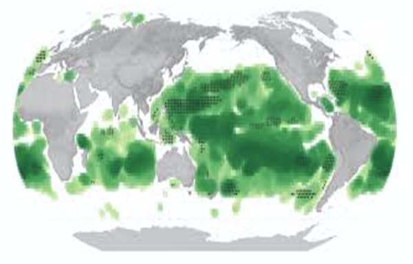
Why in news : Over half of the world's seas have changed from a deep blue to various shades of green.
About :
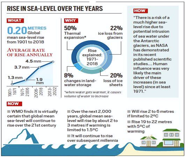
Recent satellite data reveal a striking transformation—over 56% of the world’s oceans have changed colour, shifting from deep blue to various shades of green. This subtle yet significant change, visible through NASA’s MODIS and Aqua satellites, reflects large-scale alterations in marine ecosystems. Scientists link this phenomenon to climate change, pollution, and human activities, signalling a fundamental shift in oceanic health and the biosphere’s stability.
Why Does Ocean Colour Matter?
Ocean colour serves as a biological indicator of marine health. The hue depends primarily on the concentration of phytoplankton, microscopic algae that contain chlorophyll and form the base of the marine food web.
- Greener oceans imply higher phytoplankton density, which may be beneficial in moderation but can also lead to harmful algal blooms.
- Phytoplankton absorb ~40% of global CO₂ emissions annually, playing a crucial role in the global carbon cycle.
- NASA’s MODIS data show consistent greening in the tropical and subtropical oceans (40°N–40°S), areas usually stable in seasonal variation—making the observed change a strong climate signal.
Thus, shifts in ocean colour aren’t aesthetic—they reveal fundamental biological and chemical shifts in marine ecosystems.
Factors Causing the Oceans to Turn Green
- Climate Change: Rising sea-surface temperatures promote faster phytoplankton growth in some regions while altering species composition.
- Warmer waters cause ocean stratification, limiting nutrient mixing from deeper layers.Example: In the Arabian Sea, warmer conditions have favoured Noctiluca scintillans (green algae), displacing traditional diatoms and impacting local fisheries.
- Nutrient Pollution: Agricultural runoff and wastewater discharge rich in nitrates and phosphates feed phytoplankton blooms.Example: The Gulf of Mexico “Dead Zone”—one of the largest hypoxic areas globally—results from nutrient inflow from the Mississippi River.
- Such nutrient enrichment leads to oxygen depletion and mass fish mortality events.
- Overfishing : By disrupting marine food webs, overfishing reduces natural grazers of phytoplankton like small fish and zooplankton.This trophic imbalance causes phytoplankton overgrowth, altering water colour and ecosystem stability.
- Ocean Stratification: Global warming enhances the separation between warm surface water and cold, nutrient-rich deeper water. This reduces nutrient availability for deep-water phytoplankton but benefits surface species, changing optical properties of seawater.
Effects of Greening Oceans
- Impact on Marine Biodiversity: Phytoplankton blooms can initially enhance marine productivity but may lead to harmful algal blooms (HABs) that release toxins.Example: The Red Tide in Florida (2021) caused large-scale fish kills and respiratory issues among residents.
- Oxygen Depletion: Decomposing phytoplankton consume oxygen, creating dead zones.Globally, the number of such hypoxic zones has quadrupled since the 1950s, according to UNEP.
- Climate Feedback Loops : Changes in phytoplankton types can alter the ocean’s carbon sequestration efficiency.A shift toward species that absorb less CO₂ reduces the ocean’s ability to regulate global temperatures—creating a positive feedback loop that accelerates warming.
- Economic Implications: Fisheries suffer from reduced yields and toxic blooms.
Tourism declines due to water quality deterioration, as observed along Goa’s beaches during algal bloom seasons. - Human Health Concern: Toxins from algal blooms cause shellfish poisoning and respiratory illnesses. In coastal Asia, such blooms have led to periodic bans on seafood exports due to contamination risks.
- Societal Impacts: Coastal livelihoods dependent on fishing and tourism face severe challenges, especially in developing regions. Small Island Developing States (SIDS) are particularly vulnerable due to their economic dependence on healthy marine ecosystems.
What Can We Do to Prevent the Harmful Effects of Greening Oceans?
- Reduce Carbon Emissions: Strengthen commitments under the Paris Agreement to curb global warming.Promote renewable energy and sustainable transport—India’s National Hydrogen Mission and EV policy are steps in this direction.
- Support Conservation Efforts: Expand Marine Protected Areas (MPAs)—currently covering only about 8% of the ocean surface.India’s Gulf of Mannar Biosphere Reserve serves as a model for marine biodiversity conservation.
- Promote Sustainable Fisheries: Enforce science-based quotas and reduce Illegal, Unreported, and Unregulated (IUU) fishing. FAO estimates over 34% of fisheries are overexploited, highlighting the urgency for reform.
- Enhance Ocean Monitoring and Research: Invest in technologies like NASA’s PACE satellite (2024) for tracking ocean colour and phytoplankton diversity.
Regional cooperation under INDO-GANGETIC Ocean Observation Network could help monitor South Asian waters. - Raise Awareness and Education: Public awareness campaigns—such as UNESCO’s Ocean Literacy Initiative—can drive behavioural change toward marine protection.
- Advocate for Policy Change: Integrate marine ecosystem protection into national climate policies.Strengthen international frameworks such as the High Seas Treaty (2023) to ensure equitable and sustainable ocean governance.
Conclusion
The greening of the oceans is not merely a visual curiosity—it is a biogeochemical warning from nature. It signifies the cascading effects of human-induced climate change, nutrient loading, and ecological imbalance. Addressing this challenge demands global cooperation, science-driven policymaking, and collective behavioural change. If we fail to act decisively, the transformation of blue oceans into green may become an enduring symbol of humanity’s ecological neglect.
Source : https://greenly.earth/en-gb/blog/ecology-news/are-oceans-turning-green-because-of-climate-change
Where to use :
Paper III ( General Studies ) : Climate change
Paper I ( Geography Optional ): Oceans and Climate
WESTERN GHATS CONSERVATION
Why in news : The International Union for Conservation of Nature (IUCN) has placed the Western Ghats and two national parks in India—Manas National Park and Sundarbans National Park—on its list of natural World Heritage sites with a conservation outlook of 'significant concern'.
About :
Challenges in the Western Ghats
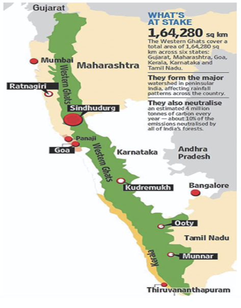
The Western Ghats, stretching about 1,600 km along India’s west coast from Gujarat to Kerala, are among the world’s eight “hottest” biodiversity hotspots
1. Deforestation and Land-Use Change
- Extent: Over 40% of original forest cover has been lost since the early 20th century (ISRO Forest Survey, 2021).
- Causes: Expansion of plantations (tea, coffee, rubber), mining, and infrastructure development (roads, railways, dams).
2. Mining and Quarrying Activities
- Issue: Unregulated mining for bauxite, iron ore, and laterite has degraded large tracts of forest and altered hydrology.
- Example: Goa’s iron ore mining belt caused deforestation and pollution of the Mandovi and Zuari rivers.
3. Biodiversity Loss and Habitat Fragmentation
- Endemism at risk: The Ghats host over 50% of India’s amphibian species and over 40% of its fish species (ZSI, 2020).
- Habitat fragmentation isolates populations, threatening genetic diversity.
- Example: Nilgiri tahr and Malabar grey hornbill face shrinking habitats due to forest fragmentation.
4. Agricultural Intensification and Monocropping
- Shift from traditional polyculture to cash crop monocultures (tea, coffee, cardamom).
- Leads to soil acidification, pesticide runoff, and depletion of groundwater.
- Example: Coffee plantations in Coorg (Kodagu) have encroached into forest corridors used by elephants, increasing human–elephant conflicts.
5. Climate Change and Landslides
- Warming trends have increased extreme rainfall events.
- IMD data (2023): Western Ghats experienced a 15–20% increase in heavy rainfall days over the past 50 years.
- Example: The Idukki landslides (2020) and Wayanad (2023) highlight growing vulnerability.
Gadgil Committee (2011) – Western Ghats Ecology Expert Panel (WGEEP)
Key Recommendations:
- Declare entire Western Ghats (64% area) as Ecologically Sensitive Area (ESA).
- Categorize region into three zones (ESZ I, II, III) based on ecological fragility.
- Ban mining, sand quarrying, and polluting industries in ESZ I.
- Encourage community-based conservation and bottom-up governance through Gram Sabhas.
- Promote sustainable agriculture and eco-friendly tourism.
Criticism:
- Viewed as too restrictive for development; faced political opposition from state governments.
Kasturirangan Committee (2013) – High-Level Working Group (HLWG)
Key Recommendations:
- Cover only 37% of Western Ghats (≈60,000 sq km) as ESA using satellite mapping.
- Focus on village-level demarcation—restrict only “natural landscapes”, not human-settled areas.
- Ban red-category industries (mining, thermal power, large construction) in ESA.
- Allow eco-friendly farming, green energy, and sustainable tourism.
- Emphasize balance between development and conservation.
Criticism:
- Considered diluted compared to Gadgil’s ecological vision.
Way Forward for Western Ghats Protection and Preservation
1. Implement Ecologically Sensitive Area (ESA) Management Effectively
- Finalize and enforce village-level ESA demarcation (as suggested by Kasturirangan Committee).
- Create zonal regulations—strict protection in high-biodiversity zones and controlled activity in buffer zones.
- Example: Kerala’s Silent Valley model shows how restricted zones with community participation can ensure both biodiversity conservation and livelihood security.
2. Promote Community-Based Conservation (CBC)
- Involve local communities, tribal groups, and farmers in co-management of forests and biodiversity.
- Encourage eco-restoration programs under MGNREGA and Forest Rights Act.
- Example: Agasthyamalai Biosphere Reserve (Kerala–TN border) successfully integrates local tribal participation in forest management.
3. Control Unregulated Mining and Quarrying
- Enforce strict Environmental Impact Assessments (EIA) and mine reclamation plans.
- Ban quarrying in ecologically fragile slopes and buffer zones.
- Example: Goa’s mining ban (2012), though temporary, helped rivers regain turbidity levels and fish populations.
4. Promote Sustainable and Climate-Resilient Agriculture
- Replace chemical-intensive cash crops with organic and mixed farming systems suited to hill ecology.
- Encourage agroforestry and spice-based multi-cropping instead of monoculture plantations.
- Example: Kodagu district’s shade-grown coffee model supports carbon sequestration and bird diversity.
5. Adopt Eco-Friendly Tourism Practices
- Implement carrying capacity limits for hill towns like Munnar and Coorg.
- Promote homestays, waste-free trekking, and eco-certification for tourism operators.
- Example: Sustainable tourism guidelines in Wayanad have reduced plastic waste and created local employment.
6. Strengthen Disaster Risk Management
- Establish early warning systems for landslides and flash floods using IMD and ISRO data.
- Promote rainwater harvesting, slope stabilization, and afforestation in degraded areas.
- Example: Post-2018 Kerala floods, the state adopted a GIS-based Landslide Hazard Zonation Mapping for better planning.
7. Integrate Climate Adaptation in Regional Planning
- Incorporate ecosystem-based adaptation (EbA) in development policies.
- Mainstream conservation into Smart City and infrastructure projects within Ghats regions (e.g., Pune, Nashik).
- Encourage green energy projects that avoid sensitive habitats.
8. Enhance Research, Monitoring, and Governance
- Establish a Western Ghats Conservation Authority (WGCA) for coordination among six states.
- Encourage real-time biodiversity monitoring using remote sensing and citizen science apps like India Biodiversity Portal.
- Strengthen collaboration between MoEFCC, state biodiversity boards, and local panchayats.
9. Promote Reforestation and Corridor Restoration
- Identify and restore wildlife corridors (e.g., Nilgiri–Wayanad–Bandipur link).
- Expand biosphere reserves and wildlife sanctuaries to connect fragmented habitats.
10. Legal and Policy Strengthening
- Update Western Ghats Conservation Rules under the Environment (Protection) Act, 1986.
- Align policies with UNESCO World Heritage Site management plans.
- Integrate Sustainable Development Goals (SDG 13 & 15) into regional frameworks.
Conclusion
The Western Ghats are not just a biodiversity treasure but a climate regulator and water source for millions. Their preservation demands a multi-dimensional approach — combining ecological science, community participation, and sustainable development. Protecting the Ghats is not about halting development but about ensuring it coexists with nature’s equilibrium.
Source :
Where to use :
Paper III ( General Studies ) : Environment Conservation and Preservation
Desert Soilification Technology
Desert soilification refers to innovative technologies that transform desert or arid lands into productive soil ecosystems. Methods like soil-crusting with clay, microbial inoculation, and moisture-retaining polymer layers enhance fertility and water retention. For instance, the Chinese “Soilification Project” in Inner Mongolia converted dunes into croplands. Such technologies embody geoengineering approaches aligned with sustainable land management (UNCCD goals), countering desertification through scientific soil–water–microbe synergy.
Geomorphic Threshold
A geomorphic threshold is the critical point at which minor external changes cause sudden, large-scale landform transformation. When stress (e.g., rainfall, tectonic movement, or human interference) exceeds this threshold, the landscape reorganizes — for example, landslides in the Western Ghats or flash floods in Himalayan valleys. It’s key to understanding non-linear dynamics in geomorphology, as introduced by Schumm (1973), linking physical geography with system stability and resilience theory.
Possibilism Dialectic
The possibilism dialectic emphasizes that humans are not passive subjects of nature but active agents shaping it, while still bounded by environmental constraints. Coined by Lucien Febvre and Vidal de la Blache, it argues that environment offers “possibilities,” and human culture chooses among them. For example, terrace farming in the Himalayas or desert irrigation in Rajasthan demonstrates adaptation through technology and culture. The dialectic balances environmental determinism with human agency in spatial development.
Environmental Kuznets Curve (EKC)
The EKC hypothesizes an inverted U-shaped relationship between income and environmental degradation. In early economic growth stages, pollution rises; beyond a threshold of affluence, societies invest in cleaner technologies and regulations, reducing pollution. For instance, SO₂ emissions declined in OECD nations after the 1980s despite GDP growth. However, critics note it ignores ecological limits and inequality, especially in developing nations where industrialization continues to stress natural ecosystems.
Feedback Mechanism (Positive/Negative)
A feedback mechanism describes how outputs of a system influence its future behavior. Positive feedback amplifies change — e.g., Arctic ice melt reduces albedo, accelerating warming. Negative feedback stabilizes systems — e.g., cloud formation from evaporation moderates temperature rise. In geography, feedback loops regulate climate systems, ecosystems, and socio-environmental processes. Understanding them aids in policy design for climate resilience and sustainable environmental management through adaptive interventions.
SUNDERBANS SUSTAINABLE AQUACULTURE
The Sunderbans (India) face a tension between livelihoods dependent on aquaculture (mainly shrimp/prawn ponds) and conservation of the mangrove landscape that provides coastal protection, biodiversity and carbon sequestration.
Several innovations and integrated approaches are emerging; the most prominent recent model is SAIME (Sustainable Aquaculture in Mangrove Ecosystems):
- Mangrove-integrated ponds: maintain 5–30% of pond or ranch areas under mangrove cover to preserve biodiversity, provide litter as natural feed, and maintain shoreline stability. This reduces feed costs (partly replaces artificial feed), supports natural productivity and enhances carbon sequestration.
- Low-input/extensive-to-semi-intensive systems: prioritise natural productivity (mangrove litter, polyculture with native species) over high-input monoculture. Yields per hectare are lower than intensive systems, but ecological and social benefits can offset that (lower input cost, higher resilience).
- Community governance & co-management: community groups manage mangrove patches, share nursery and seed resources, and negotiate pond-mangrove mosaics — improving compliance and stewardship.
- Technical support & capacity building: ICAR and state extension agencies have run adoption and training programmes (e.g., ICAR-CIFRI and other ICAR initiatives supporting smallholder adoption of sustainable practices and alternate livelihoods).
- Land conversion (selected estimate): ~3,320 ha of mudflats/mangrove transformation to aquaculture/other uses in 1999–2019 in parts of the delta
- Mangrove retention in SAIME: recommended/implemented 5–30% mangrove cover within pond landscapes as a working range to balance production and ecosystem services (documented in policy briefs and FAO/coverage).

Where to use :
Paper II ( Geography Optional ) : Fisheries
Places in News - 24 October 2025
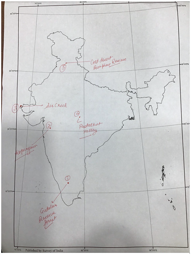
1. Gudalur Reserve Forest
Why in news : The mass flowering of Kurinji after eight years in Tamil Nadu’s newly notified Gudalur Reserve Forest in the Nilgiris signals biodiversity recovery and serves as an indicator of healthy grasslands and changing climate conditions.
About :
- Situated in the Nilgiri District of Tamil Nadu, at the tri-junction of Tamil Nadu, Kerala, and Karnataka.
- Receives 2,000–3,000 mm annual rainfall, influenced by both Southwest and Northeast monsoons.
- Temperature varies between 15°C–25°C, creating a montane subtropical climate.
- Dominant soils: Lateritic and red loamy soils with high organic content.
- Vegetation includes tropical evergreen, semi-evergreen, and moist deciduous forests — part of the Nilgiri–Wayanad–Coorg elephant corridor.
2. Kopargaon
Why in news : Union Home Minister and Minister of Cooperation inaugurated India’s first cooperative multi-feed Compressed Biogas (CBG) plant in Kopargaon, Maharashtra.
About :
- Kopargaon is a town in Ahmednagar district, Maharashtra, situated on the northwestern bank of the Godavari River.
- Lies near Shirdi (about 15 km away) and forms part of the upper Godavari basin — a fertile alluvial tract of western Maharashtra.
- The region is part of the Deccan Plateau, underlain by Basalt (Deccan Traps).
- Soils are black cotton soils (Regur) derived from lava rocks, rich in iron and clay, suitable for sugarcane, cotton, and cereal cultivation.
3. Sir Creek
Why in news : India’s Defence Minister has stated that any aggressive action by Pakistan in the Sir Creek area would be responded to firmly, highlighting India’s readiness and vigilance.
About :
- Sir Creek is a 110 km long tidal estuary located in the Rann of Kutch, forming part of the India–Pakistan boundary between Gujarat (India) and Sindh (Pakistan).
- It opens into the Arabian Sea, lying between Kutch (India) and Karachi coast (Pakistan).
- It is a distributary of the Indus River delta system, characterized by mudflats, salt marshes, and mangroves.
- Part of the Indo-Pacific flyway, supporting migratory birds.
- Mangrove ecosystems here act as carbon sinks and buffers against coastal erosion.
- Forms a key link between Kutch desert ecology and the Arabian coastal wetlands.
4. Paatalkot Valley
Why in news : First Health Centre was inaugurated in the remote tribal valley of Paatalkot in Chhindwara district (MP), marking a significant step towards last-mile delivery of government services.
About :
- Paatalkot is a deep valley situated in the Tamia block of Chhindwara district, in the Satpura ranges of Madhya Pradesh.
- Lies about 78 km from Chhindwara town and is spread over roughly 79 sq km, at an elevation of around 2750 feet (≈ 830 m) above sea level.
- It supports rare flora used in traditional herbal medicine by local tribes like Bhil, Gond, and Bhariya.
- The valley is often termed a “living herbal museum” due to its rich medicinal biodiversity.
5. Cold Desert Biosphere Reserve
Why in news : The Cold Desert Biosphere Reserve (CDBR) in Himachal Pradesh, along with 25 other biosphere reserves across several countries, has been included in World Network of Biosphere Reserves (WNBR) by UNESCO.
About :
- The Cold Desert Biosphere Reserve lies in the Trans-Himalayan region of Himachal Pradesh, covering parts of Lahaul, Spiti, and Kinnaur districts.
- It was established in 2009, spreading over an area of approximately 7,770 sq km.
- The core area includes the Pin Valley National Park, while the buffer zone extends into adjacent cold desert regions.
- Exhibits an extreme cold desert climate — long, harsh winters with temperatures dropping below –30°C, and short, dry summers.
- Monasteries like Ki and Tabo are cultural landmarks reflecting Tibetan Buddhist influence.
Fortnightly KOSMOS MCQs Practice - 24th October 2025
Q1. Consider the following statements regarding Orbiting Carbon Observatories (OCOs):
1. The OCOs are a series of Earth observation satellites designed to provide crucial data for tracking CO2 sources and sinks.
2. They are managed jointly by ISRO and NASA.
3. OCO-3, installed on the International Space Station orbits Earth every 90 minutes, allowing observations of the same location at multiple times of the day.
Which of the statements given above is/are correct?
- 1 and 2 only
- 2 and 3 only
- 1 and 3 only
- 1, 2, and 3
Q2. The ‘Rhisotope Project’, recently in news, primarily aims to:
- Promote renewable energy adoption in wildlife conservation areas.
- To inject radioactive isotopes into rhino horns to make them poisonous for human consumption.
- Implement blockchain technology to track and verify the legality of wildlife products.
- Enhance community-based eco-tourism initiatives for sustainable livelihoods.
Q3. Consider the following statements with reference to ‘Black Aspergillus’:
1. Scientists have discovered two new species of black aspergillus from the Western Ghats, marking India’s first study in this group using advanced polyphasic taxonomy.
2. It comprises a diverse group of filamentous fungi that are ubiquitously distributed across various ecological niches.
3. It is known as ‘workhorses of industrial application’ especially in citric acid production, food mycology, fermentation technology, and agriculture.
Which of the statements given above is/are correct?
- 1 and 2 only
- 2 and 3 only
- 1 and 3 only
- 1, 2 and 3
Q4. Consider the following statements regarding the La Niña and El Niño phenomena:
1. La Niña is characterized by the weakening of trade winds, leading to an increase in sea surface temperatures in the central and eastern Pacific.
2. La Niña typically results in colder-than-normal winters in northern India, particularly in Jammu & Kashmir and Himachal Pradesh.
3. The World Meteorological Organization (WMO) was established as a UN specialized agency to focus on weather, climate, and hydrological sciences.
Which of the above statements is/are correct?
- 1 and 2 only
- 2 and 3 only
- 1 and 3 only
- 2 and 3 only
Q5. Consider the following types of protected areas in India:
1. Conservation Reserve
2. National Park
3. Wildlife Sanctuary
4. Community Reserve
Arrange them in the correct order of strictness of protection, from most protected to least protected.
- 2 → 3 → 4 → 1
- 2 → 3 → 1 → 4
- 1 → 2 → 3 → 4
- 4 → 2 → 3 → 1
Q6. Consider the following statements:
1. Under UNCLOS, artificial islands and land reclamation activities do not change the legal status of naturally occurring rocks or reefs.
2. China’s “Nine-Dash Line” claim in the South China Sea overlaps with the Exclusive Economic Zones (EEZs) of Vietnam, the Philippines, Malaysia, and Brunei.
Which of the above statements is/are correct?
- 1 only
- 2 only
- Both 1 and 2
- Neither 1 nor 2
Q7. Which of the following statements about Great Nicobar Island is correct?
- The Andaman and Nicobar Islands are divided by the Eight Degree Channel.
- Indira Point, India’s southernmost tip, is located on Great Nicobar Island.
- Great Nicobar Island has been part of the Man and Biosphere (MAB) Program of UNESCO since 2003.
- The island is uninhabited and has no tribal populations.
Q8. With reference to “Phosphate Rock,” which of the following statements is/are correct?
1. It is a sedimentary rock rich in phosphate minerals, formed over millions of years from accumulations on ancient ocean floors.
2. It is mostly extracted through deep underground shaft mining due to the great depth of deposits.
3. The largest deposits are in Morocco; major reserves also occur in Africa, North America, Kazakhstan, and the Middle East, while in India key production is in Rajasthan and Madhya Pradesh.
Select the correct answer using the code given below:
- 2 and 3 only
- 1 and 3 only
- 1 only
- 1, 2 and 3
Q9. With reference to Rare Earth Minerals, consider the following statements:
1. Despite their name, these minerals are relatively abundant in the Earth's crust, but are difficult to mine and extract economically.
2. They are critical components in the manufacturing of high-technology products such as semiconductors, electric vehicle motors, and missile guidance systems.
3. India is the world's largest producer, dominating the global supply chain for these strategic minerals.
Which of the statements given above is/are correct?
- 1 and 2 only
- 2 only
- 1 and 3 only
- 1, 2 and 3
Q10. With reference to the Forest Advisory Committee (FAC) in India, which of the following statements is/are correct?
1. It is a statutory body constituted under the Environment (Protection) Act, 1986.
2. Its primary role is to advise the government on proposals for the diversion of forest land for non-forest uses.
3. The recommendations made by the FAC are legally binding on the Central Government.
Select the correct answer using the code given below:
- 1 and 2 only
- 2 only
- 1 and 3 only
- 1, 2 and 3
Share the article
Edukemy’s Current Affairs Quiz is published with multiple choice questions for UPSC exams
MCQ
Get Latest Updates on Offers, Event dates, and free Mentorship sessions.

Get in touch with our Expert Academic Counsellors 👋
FAQs
Geography Current Affairs focuses on the contemporary issues, events, and developments in the field of geography. It covers recent geographical phenomena, environmental changes, geopolitical shifts, and related news. This differs from regular geography studies which may focus more on foundational concepts, historical contexts, and theoretical frameworks.
Updates are provided regularly to ensure that subscribers stay informed about the latest developments in geography. Typically, updates are provided on a fortnightly basis, depending on the frequency of significant events and changes in the field.
Absolutely. Geography Current Affairs serves as a valuable resource not only for Geography optional but also for GS papers, especially GS Paper 1 (covering Indian Heritage and Culture, History, and Geography of the World and Society) and GS Paper 3 (covering Technology, Economic Development, Biodiversity, Environment, Security, and Disaster Management). It aids in building a holistic understanding of various topics and strengthens answer-writing skills by incorporating contemporary examples and perspectives.
Geography Current Affairs holds immense importance for UPSC preparation, particularly for aspirants opting for Geography optional. It helps candidates stay updated with the latest developments, geographical phenomena, environmental issues, and geopolitical shifts worldwide, aligning them with the dynamic nature of the subject as tested in the UPSC examinations.