
10 Aug to 24 Aug, 2025
Forest_fires
Why in the News: Wildfires in Albania, Greece, Italy, Portugal, Spain, and Turkey have resulted in fatalities and forced thousands to evacuate the affected regions.
About :
Background:
- Forest fires have occurred across the globe at various times in the The sources of these fires have been both natural and anthropogenic.
- Forest areas in North America, South and S E Asia, Australia, Africa and Amazonia are prone to the incidence of fires regularly.
- Forest fires occur almost on an annual basis in the deciduous forests of Southern India.
- To get a forest fire starting, three elements must be contemporarily present: a heat source, fuel and oxygen. If one of the three elements is not present (anymore), the combustion reaction cannot start.

Types of Forest fires:
Forest fire broadly classified into three categories:
- Surface fire : Spread with flaming front and burn leaf litter, fallen branches and other fuels located at ground level.
- Ground fire: Burning of organic matter in soil beneath the surface litter and are sustained by glowing combustion.
- Crown fire: Burn through the top layer of foliage on a tree , known as the canopy or crown fires.They are the most intense and difficult to contain
NATURAL CAUSES OF FOREST FIRES

- Volcanic Eruption : Extreme heat of lava may cause vegetation to catch fire and spread. Mauna Ulu eruption in Hawai in 1970s burnt the Naulu forest.
- Lightning : Forest fires frequently happens when lightning bolts continue for an abnormally long time or when they strike a dry material. In 2022, 90% of forest fires in boreal forest of Northern Canada and Alaska triggered by lightning.
- High atmospheric temperatures: High temperature and dryness offer favourable conditions for fire because of lack of moisture. In 2022, fires triggered in Arctic forests due to rising temperatures.
- Dry bamboos : In bamboo areas, forest fires may occur by rubbing together of clumps of dry bamboos. Bamboo bushes in Kakatiya Van Vihar in Telengana caught fire recently.
- El Niño conditions : El Niño , causing extreme dry conditions triggered one of the most severe fire seasons in 2015 in Indonesia.
ANTHROPOGENIC CAUSES
- Shifting cultivation : Shifting agriculture is the dominant driver of forest disturbance in India, especially in North Eastern states.
- To get god grass/ fodder crop : In the upper Himalayan mountain, areas where natural forests still exist , massive fires are set intentionally to get fodder for animals.
- Flush for tendu leaves : In central India, fires are ignited in the forest to increase the production of tendu leaves. Tendu leaves collectors set fires in the summer months to promote a better flush of leaves.
- To conceal illicit felling : Smugglers and poachers in jungles of Odisha are caught many times setting forest fires to hide the stumps of illicit felling. The poachers use forest fires for terrorising wild animals and hunting too.
- Burning farm residue: After harvest, farmers in Haryana , Punjab , UP and Bihar set fire to their agricultural fields. Many times, when these fires are not put out completely, may spread to the adjoining forest areas.
- Protecting crops from wild animals : Villagers residing in or near the forest many times light up the fire in the forest to keep the wild animals away from their crops and cattle.
- Careless travelling : Travellers, picnickers, nomadic grazers, villagers or even forest labourers some time throw un-extinguished cigarettes, bidis, and match sticks in the forest areas. In 2012 , Israeli tourist was arrested for causing forest fire in Chile.


BENEFITS OF FOREST FIRES
- Cleaning the Forest Floor : With the help of fire low-growing underbrush is burned off, the forest floor is cleared of debris, the forest gets exposed to sunshine, and the soil is nourished.

- Promotes biodiversity : The heavy brush is removed from wildlands by fire, making way for fresh grasses, herbs, and regenerated shrubs that provide food and Habitat for various wildlife species.
- Killing Disease : Fire destroys diseases and pests that harm trees while supplying essential nutrients for soil improvement. Rather than fire, Disease and insect infestation claim the lives of more trees each year.
- New Generations : Some trees have bark that can withstand fires and cones that must be heated to open and release seeds for regrowth. Manzanita, chamise, and scrub oak are examples of chaparral plants that also need a lot of heat to germinate their seeds.
- Fire prevents fire : Regularly occurring small wildfires actually prevent bigger, more destructive fires from happening in the future. If a forest doesn’t have a burn for a long time, dead trees and other fuel builds up, causing a much more destructive, out-of-control fire later.
IMPACTS OF FOREST FIRES
- Pollution : The Hyderabad-based NRSC study revealed that concentrations of trace gases and aerosols rose to alarming levels in Uttarakhand p during a massive fire in April-May 2016.
- Deteriorated Water quality : The introduction of fire retardant chemicals into waterbodies can reach levels toxic to aquatic organisms, as seen in Mexico.
- Health & illnesses : Smoke from fires set in the Amazon region is one of the key causes of respiratory hospitalisations of indigenous people, states in study.
- Loss of resources : The planet continues to experience a massive loss in forest land. The U.S. has lost 29.7 million acres of tree cover from forest fires since 2001.
The U.S. has lost 29.7 million acres of tree cover from forest fires since 2001.
- Disruption of carbon cycle : Forest fire caused the loss of carbon sequestered in forest biomass carbon stock. In the future, due to climate change, a greater number of forest fire events may occur and disturb the carbon cycle.
- Damage to flora and fauna : Forest causes severe threat to flora and fauna. Mammals, reptiles, birds and frogs died in the forest fires every year.
- Soil erosion: In Portugal, as well as in other Mediterranean countries, forest fires has caused soil erosion . Vegetation cover is an important factor in determining runoff and erosion risk.
- Depleting ozone layer : Forest fires in Australia continued from June 2019 to March 2020, and released over 1 million tonnes of smoke that reached to the stratosphere and affected the ozone layer.
- Microclimate change : The changed microclimate caused by the removal of litter and duff, opening of the canopy by killing over storey shrubs and trees and darkening of the soil surface by residual soot and charcoal can increase insulation causing temperature increase.
STATUS OF FOREST FIRES ACROSS THE GLOBE
- Most of North and South America, the African plateau, the northern Arabian Peninsula, and the Mediterranean coast of Europe as well as Northern and Eastern Europe have been affected by fires.
- In Asia, fires have been detected on the coasts of India and in Russia's Siberia region as well as in China, Malaysia and Indonesia.
- European countries with Mediterranean coasts such as Italy, Spain, and Greece are also struggling with forest fires.
STATUS OF FOREST FIRES IN INDIA
- According to Forest Survey of India website , there are 337 large Forest fires in the country as of March 14 in this year with 38 in Arunachal Pradesh, 18 in Jharkhand, 16 in Manipur, 15 in Meghalaya, 44 in Mizoram and 147 in Odisha, among others
- The forest fires in Odisha come in the backdrop of the state not receiving any rain since October, which has resulted in forests experiencing dryness and the forest fires spreading.
- Andhra Pradesh, Assam, Chhattisgarh, Odisha and Maharashtra are the most prone to high-intensity forest fire events caused by rapid change in climate.
- Mizoram had the highest number of forest fire incidences in the last two decades, with more than 95% of its districts being forest fire hotspots.
- Earlier, forest fires would take place during the summer months, that is between May and June. Now, during spring, between March and May, because of climatic changes.
- The duration that forest fires could take place was two to three months earlier, but it is now nearly six months.

INSTANCES OF FOREST FIRES IN INDIA ( RECENT )
- The Himachal Pradesh and Nagaland-Manipur border saw prolonged fires in January.
- There was a major wildfire between February and March in the Simlipal National Park in Odisha.
- According to the Indian Express, Southern Chhattisgarh, Central Odisha, Western Maharashtra, and areas of Andhra Pradesh and Telangana are highly prone to forest fires.
- Bandhavgarh Forest Reserve in Madhya Pradesh and sanctuaries in Gujarat also witnessed forest fires.


GOVERNMENT INITIATIVES TO PREVENT FOREST FIRES IN INDIA
- The National Forest Policy of Government of India, 1952 states that the claims of the communities residing near forests should not override national interest. This was done in order to protect the forests from incessant exploitation, thus cultivation and other related activities were allowed only in unclassified forest land.
- National Mission for Green India, introduced in 2014 aims at protecting and enhancing the forest cover of the country by involving the local communities in planning and decision-making of the same.
- Compensatory Afforestation Fund Management and Planning Authority (CAMPA) was introduced in 2014, to check the usage of unspent money raised by the central and the state governments.
- The Central Government is also providing assistance to the State Governments under the centrally sponsored scheme – the National Afforestation Program (NAP) “for regeneration of degraded forests and adjoining areas through people’s participation.
- Since 2004, the Forest Survey of India(FSI) developed a Fire Alert System. The system will monitor forest fires in real-time. In 2019, an advanced version of the system was also launched.
- Using the MODIS sensors(Moderate Resolution Imaging Spectroradiometer) Real-time fire information of fire hotspots is collected and sent to FSI. This is then forwarded by email to state, district, circle, division, range and beat levels. People in the locality will also receive SMS alerts.
COUNCIL ON ENERGY , ENVIRONMENT AND WATER RECOMMENDATIONS FOR MANAGING FOREST FIRES
- Recognise forest fires as a disaster type and integrate them into national, sub-national and local disaster management plans.
- Develop a forest fire- alert system, which does not segregate forest fires from other fires such as waste burning and crop burning.
- Enhance adaptive capacity with training on high technology-focused equipment (like drones) and nature-based modules such as creating effective forest fire lines.
- Provide clean air shelters in public buildings or government schools to create clean air shelters for communities worst impacted by fires and smoke from forest fires.
WAY FORWARD :
- Revision of Indian Forest Act with some relevant section needs to be revised to give due importance to legal protection against man-made forest fire.
- Designing and installing a network of fire forecasting at National and State levels in collaboration with the Meteorological Department.
- International coordination along with organising seminars, training programs, conferences, and study tours in different countries leading in Forest Fire Management, e.g., U.S.A., Australia, U.K., Spain, France, etc.
- Need to work on a new system of issuing pre-fire alerts to prevent such incidents.
- Designing syllabus for planning, management, ground level firefighting courses in Forestry Institutions.
- Promotion of people’s participation through involvement of NGOs, Voluntary Organisations, Village Forest Committees (VFCs)
- Creation of Forest Self-Help Groups (FSHGs) or local Forest Special Purpose Vehicles (FSPV) — with an industrial linkage to the removal of dry needles with the help of villagers.
- Set up National Institute of Forest Fire Management with satellite centers in different parts of India with an objective to bring the latest forest fire fighting technologies to India through proper research, training of personnel etc.
CONCLUSION :
Forest fires have been a local issue with global impact, which may happen more frequently than the recent past due to impact of rising temperature and global warming. As populations grow with expansion of industrial development into forested areas and climate change alters fire regimes, the risk to communities and infrastructure will likely increase. Mischievous fires originated from villages near the forest areas are the major causal factors for fire incidences. Therefore, sensitisation of people and their social awakening through various meeting with villagers/ settlers and awareness campaigns about the negative consequences of forest fires on their health, environment and degradation of natural resources can be very effective to prevent forest fires.
Where to use ?
Paper I ( Geography Optional ) : Environmental Geography
Paper II ( Geography Optional ) : Forest fires and Climate Change
CONTRASTING PATTERNS OF HEATING
Why in news : The contrasting pattern of heating and cooling in the North Atlantic Ocean is linked to the slowdown of the Atlantic Meridional Overturning Circulation
About :
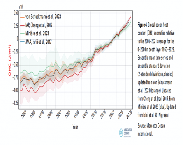
- As the global climate continues to change, the oceans play a pivotal role in the Earth's energy balance. In 2023, the heat content of the world's oceans not only reached a new record high but also exhibited a complex pattern of both warming and cooling regions.
Record Ocean Heat Content
- The WMO's State of the Global Climate 2023 report underscores a significant milestone in the ocean's heat content. Last year, the oceans stored energy exceeded the previous records, marking a concerning trend in global warming. Specifically, the ocean heat content in 2023 surpassed the 2022 , a stark indicator of the ongoing accumulation of thermal energy in the marine environment.
- Unprecedented Sea-Surface Temperatures: Alongside rising ocean heat content, global average sea-surface temperatures (SST) also reached record highs in 2023.
- Exceptional warming was observed across vast stretches of the oceans, from the eastern North Atlantic and the Gulf of Mexico to the North Pacific and the Southern Ocean.
- The monthly records for July, August, and September were shattered by margins of about 0.21-0.27°C. This trend has continued into 2024, with January witnessing an average global SST of 20.97°C over the 60°S-60°N range, the highest ever recorded for that month.
- The Cooling Anomaly- The North Atlantic Cold Blob: Contrasting the general trend of ocean warming, a relatively small region in the subpolar North Atlantic Ocean has been experiencing cooling. This area, extending from the surface down to depths of over 800 meters, has seen a decrease in sea surface temperatures by approximately -17.3 degrees Celsius over the past century. This phenomenon, often referred to as the North Atlantic cold blob, is thought to be driven by complex interactions between the ocean and atmosphere, including the slowdown of the Atlantic Meridional Overturning Circulation (AMOC).
- The AMOC and Climate Implications : The AMOC, a crucial system of ocean currents that redistributes heat across the Atlantic, is showing signs of instability. Recent research published in 2024 indicates that the AMOC is approaching a tipping point, with potential future collapse posing severe threats to the climate of the North Atlantic region. The AMOC's slowdown is linked not only to the cooling observed in the subpolar North Atlantic but also to broader climatic impacts, including shifts in weather patterns and sea level rise.
Conclusion
The record ocean heat content and SSTs , juxtaposed with the cooling in parts of the North Atlantic, highlight the complexity of climate change and the critical role of the oceans. With approximately 90% of the excess energy in the Earth system stored in the oceans, unraveling these dynamics is crucial for predicting and mitigating future climate impacts.
Source
Where to use:
Paper 1 ( Geography Optional ) : Climatology
Paper 1 ( General Studies ) : Ocean currents
FLASH FLOODS IN UTTARAKHAND
Why in News? : The flash flood that struck Dharali village in Uttarkashi, Uttarakhand, is a stark reminder of the increasing threat of disasters caused by extreme weather events in the Indian Himalayan Region (IHR).
About :
Flash Flooding : Flooding that begins within 6 hours, and often within 3 hours, of the heavy rainfall (or other cause).
There are two basic types of floods: flash floods and the more widespread river floods. Flash floods generally cause greater loss of life and river floods generally cause greater loss of property.
A flash flood occurs when runoff from excessive rainfall causes a rapid rise in the water height (stage) of a stream or normally-dry channel. Flash floods are more common in areas with a dry climate and rocky terrain because lack of soil or vegetation allows torrential rains to flow overland rather than infiltrate into the ground.
River flooding is generally more common for larger rivers in areas with a wetter climate, when excessive runoff from longer-lasting rainstorms and sometimes from melting snow causes a slower water-level rise over a larger area. Floods also can be caused by ice jams on a river or high tides, but most floods can be linked to a storm of some kind.
Causes of Floods
1. Climatic Causes
- Monsoonal Concentration of Rainfall:
Over 75–80% of annual rainfall occurs during June–September due to the southwest monsoon. Its spatial and temporal variability often results in high-intensity rainfall in short duration, overwhelming river basins.Example: 2018 Kerala floods were triggered by extreme rainfall (>250 mm/day in several districts). - Cyclonic Storms and Depressions:
Tropical cyclones in Bay of Bengal and Arabian Sea bring torrential rains, storm surges, and river flooding.Example: Odisha super cyclone (1999), Cyclone Amphan (2020) led to flooding in coastal Odisha and West Bengal. - Snowmelt and Glacial Lake Outburst Floods (GLOFs):
Himalayan catchments often witness floods due to sudden snowmelt or bursting of moraine-dammed lakes.Example: Chamoli (Uttarakhand) disaster of 2021 caused by a glacial burst.
2. Physiographic and Geomorphological Causes
- Low-lying Plains and Riverine Topography:
The Ganga-Brahmaputra basin is prone to floods due to flat terrain, poor drainage, and meandering rivers.Example: Assam’s Brahmaputra floods annually affect 2–3 million people. - Siltation and Aggradation of River Beds:
Himalayan rivers carry heavy sediment load (due to erosion, deforestation, seismic activity). Silt deposition raises riverbeds and reduces carrying capacity.
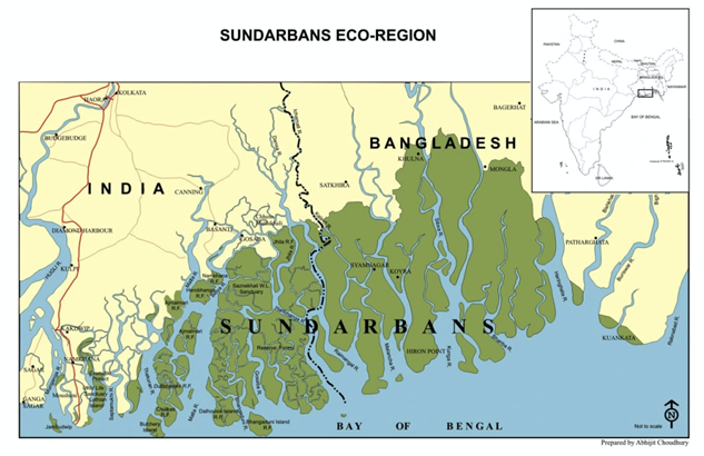
Example: Kosi River, called the “Sorrow of Bihar,” frequently changes course due to siltation and causes catastrophic floods. - Coastal Flooding:
Sea-level rise, tidal surges, and estuarine flooding affect deltaic regions.
Example: Sundarbans region faces saline water inundation during cyclonic surges.
3. Anthropogenic Causes
- Deforestation and Land Use Change:
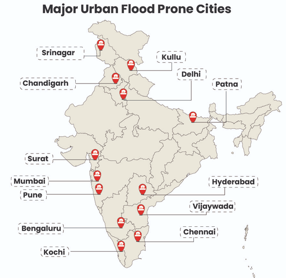
Himalayan deforestation reduces interception and increases runoff, enhancing flash floods.Example: Alaknanda floods (1970) were linked to deforestation and road construction. - Urbanization and Poor Drainage:
Encroachment of wetlands, concretization, and blocked drainage channels exacerbate urban floods.Example: Chennai floods (2015) due to blocked waterways like Adyar river floodplain and Pallikaranai marsh.Example: Mumbai (2005) floods worsened by encroachment of Mithi river. - Dam Mismanagement:
Sudden release of water from reservoirs leads to downstream flooding.Example: In 2018, Kerala floods were aggravated by uncoordinated dam releases. - Agricultural Practices:Unscientific cultivation in catchments (shifting cultivation in Northeast, intensive farming in Punjab-Haryana) increases soil erosion and sediment load.
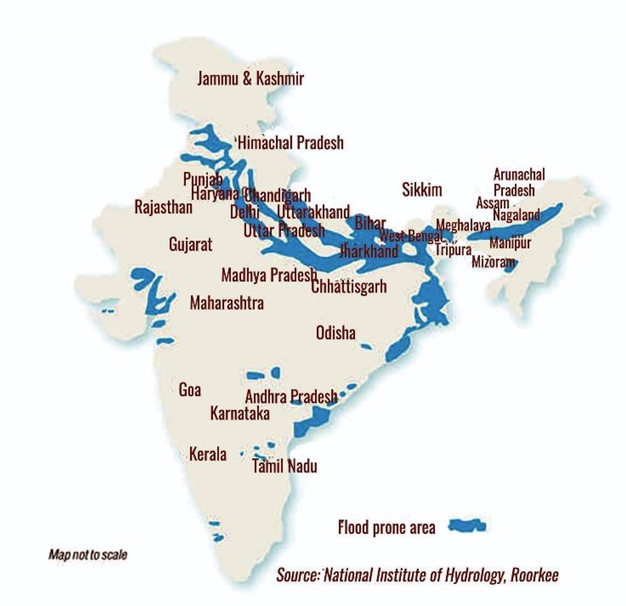
Distribution of Floods in India
Floods in India show regional concentration, influenced by climate, physiography, and river systems.
1. Indo-Gangetic-Brahmaputra Plains (Highest Flood-Prone Zone)
- Ganga Basin (UP, Bihar, West Bengal): Annual floods due to monsoon rainfall + siltation.Example: Kosi floods (2008) displaced ~3 million in Bihar.
- Brahmaputra Basin (Assam): Flash floods from heavy rainfall + sediment load.Example: Assam floods (2022) affected 5 million people.
2. Northwestern India
- Punjab–Haryana Plains: Floods from Sutlej, Beas during heavy monsoons.
- Rajasthan (Desert): Cloudbursts cause localized flash floods.
Example: Barmer flash floods (2006).
3. Himalayan & Sub-Himalayan Region
- Prone to flash floods, cloudbursts, GLOFs.Example: Kedarnath floods (2013), Chamoli GLOF (2021).
4. Eastern Coastal Plains
- Cyclone-induced floods due to storm surges + torrential rain.Example: Odisha floods after Cyclone Phailin (2013).
Krishna–Godavari delta often inundated.
5. Western Coastal Plains
- Short, swift rivers + urbanization → urban floods.
Example: Mumbai floods (2005), Kerala floods (2018).
6. Central India (MP, Chhattisgarh, Jharkhand)
- Moderate but recurring floods in Narmada, Mahanadi basins.
Example: Mahanadi floods in Odisha (2011).
Measures to Control Flood RIsks in India
1. Structural Measures
(a) Embankments and Levees
- Raised banks to contain rivers during peak discharge.
- Example: Embankments along the Kosi and Gandak in Bihar; Brahmaputra embankments in Assam.
- Limitation: Often breached due to poor maintenance and siltation (e.g., Kosi breach in 2008).
(b) Dams and Reservoirs
- Storage structures moderate flood peaks by retaining excess water.
- Example: Hirakud Dam on the Mahanadi (Odisha) built after the 1937 floods, one of the largest flood-control projects.
- Limitation: Uncoordinated water release (as seen in Kerala floods, 2018) may aggravate downstream flooding.
2. Non-Structural Measures
(a) Flood Forecasting and Early Warning Systems
- IMD and Central Water Commission (CWC) issue flood forecasts for 325 stations in 20 river basins.
- Example: Real-time flood monitoring through Flood Early Warning System (FEWS) on the Brahmaputra with help from ISRO satellites.
(b) Flood Plain Zoning and Land Use Planning
- Restricting habitation, infrastructure, and agriculture in flood-prone areas.
- Example: Uttarakhand High Court banned construction within 200m of Ganga in Haridwar–Rishikesh stretch (2017).
- Limitation: Flood plain zoning bill (1975) has seen poor implementation by states.
Policy and Programme Initiatives
- National Flood Control Programme (1954): Launched after devastating floods of 1953; led to construction of embankments, drainage works, and dams.
- National Water Policy (2012): Emphasized floodplain zoning, integrated water resources management, and ecosystem-based approaches.
- Rashtriya Barh Aayog (1980): Recommended watershed treatment, embankment strengthening, and flood plain zoning.
- National Disaster Management Act (2005): Established NDMA, mandated flood preparedness and risk reduction strategies.
- Flood Management and Border Areas Programme (FMBAP, 2017–2020): Centrally sponsored scheme to strengthen embankments in North-Eastern states and Indo-Bangladesh border rivers.
- Namami Gange Programme: Includes riverfront development and floodplain conservation to reduce floods and improve river health.
Innovative & Emerging Measures
- Remote Sensing & GIS: Used for flood hazard mapping (ISRO’s Bhuvan platform).
- Eco-based Adaptation: Revival of wetlands like East Kolkata Wetlands for natural flood buffering.
- Climate Resilient Infrastructure: Smart cities integrating sponge city concepts (e.g., Kochi under Smart Cities Mission).
- International Cooperation: Indo-Bangladesh joint monitoring of Ganga and Brahmaputra for flood forecasting.
Conclusion
Flood management in India must move beyond structural “control” towards Integrated Flood Management (IFM), blending engineering, ecological restoration, community resilience, and policy enforcement. With climate change intensifying extreme rainfall and glacial melt, sustainable strategies—such as floodplain zoning, wetland restoration, and real-time early warning systems—will be the cornerstone of reducing future flood risks.
Where to use :
Paper II ( Geography Optional ) : Flash Floods
Zombie_Fire
Zombie Fire : Zombie fires are underground wildfires that continue to smolder beneath the soil surface, particularly in carbon-rich peatlands, even after the visible flames are extinguished. They survive through winter under snow and reignite during warmer months, contributing to persistent greenhouse gas emissions. Found mainly in Arctic and boreal regions, they accelerate permafrost thaw and release stored carbon, worsening climate change. Their recurrence poses significant challenges for fire management, carbon accounting, and ecosystem recovery.
Orbiting Carbon Observatories
Orbiting Carbon Observatories : Orbiting Carbon Observatories are NASA’s specialized satellites designed to monitor global carbon dioxide concentrations in Earth’s atmosphere with high precision. OCO-2 (launched 2014) and OCO-3 (installed on the International Space Station in 2019) provide critical data on sources (fossil fuel combustion, deforestation) and sinks (forests, oceans) of CO₂. These satellites help track seasonal variations, regional emissions, and absorption patterns, enhancing climate modeling. Such observations are essential for understanding carbon cycles, predicting climate impacts, and shaping international climate policies.
Biochar_24 August 2025
Biochar : Biochar is a carbon-rich, porous material produced by pyrolysis (burning biomass like crop residues or wood at low oxygen levels). It is highly stable and can remain in soils for centuries, making it a powerful carbon sequestration tool. When added to soil, biochar improves water retention, nutrient availability, and microbial activity, boosting agricultural productivity. It also prevents the release of methane and nitrous oxide. As a climate mitigation strategy, biochar offers dual benefits—soil health improvement and long-term carbon storage.
Monocotyledon_24 August 2025
Monocotyledon : Monocotyledons, or monocots, are one of the two main groups of angiosperms (flowering plants), characterized by seeds with a single cotyledon (embryonic leaf). They typically have parallel leaf venation, fibrous root systems, and flower parts in multiples of three. Stems lack secondary growth, making most monocots herbaceous. Major plant families include grasses, palms, orchids, and lilies. Economically vital crops like rice, wheat, maize, and sugarcane belong to this group, forming the backbone of global food and fodder systems.
Data Carbon ladder_24 August 2025
Data Carbon ladder : The Data Carbon Ladder is a digital sustainability tool designed to calculate carbon emissions generated by digital data usage and storage. It estimates the carbon footprint of activities like cloud computing, data transfer, and storage in data centers, which consume significant energy. Businesses can use this tool to assess and offset their digital carbon impact, promoting greener IT practices. By quantifying “invisible emissions” from the digital economy, the Data Carbon Ladder supports climate action, corporate accountability, and energy-efficient data management.
CLIMATE INDUCED MIGRATION - SAGAR ISLAND, SUNDERBANS INDIA
Sunderbans, home to about 4.5 million people, is facing the unprecedented wrath of natural calamities , owing to recurring Cyclones like Amphan, sea level rise ( 3.14mm per year ) , salt water intrusion and tidal surges. Such environmental disasters have already pushed 69000 residents to mainland India and Bangladesh. Inadequate income opportunities, exploitation by money lenders, damage to weak infrastructure , rice and betel cultivation impact due to soil salinity combined together results in climate induced migration.
Source :
https://www.dw.com/en/forgotten-people-sundarbans-climate-refugees-forced-to-move-again/a-61162969
Where to use :
Paper I ( Population Geography ) : Migration
Paper III ( General Studies ) : Environment disasters
Places in News - 24 August 2025
1. Gulf Of Mannar
Why in news : The Gulf of Mannar (GoM) in Tamil Nadu, severely affected by coral bleaching has implemented artificial reef restoration using triangular and perforated trapezoidal modules placed underwater via divers.
About :
- Gulf of Mannar, inlet of the Indian Ocean, between southeastern India and western Sri Lanka is bounded to the northeast by Rameswaram (island), Adam’s (Rama’s) Bridge (a chain of shoals), and Mannar Island.
- The gulf is 80–170 miles (130–275 km) wide and 100 miles (160 km) long. It receives several rivers, including the Tambraparni (India) and the Aruvi (Sri Lanka).
- The port of Tuticorin is on the Indian coast. The gulf is noted for its pearl banks and sacred chank (a gastropod mollusk).
2. Dibru-Saikhowa National Park (DSNP)
Why in news : Dibru-Saikhowa National Park (DSNP) in Assam is witnessing significant ecological changes due to native and invasive plant species.
About :
- Located in Assam, is bounded by the Brahmaputra and Lohit Rivers(north) and Dibru River (south).
- In 1997, UNESCO designated the area as a Biosphere Reserve.
- Semi-evergreen, deciduous, littoral, swamp, and wet evergreen forests, including the largest Salix swamp forest in northeast India.
- It has a tropical monsoon climate with hot, wet summers and cool, dry winters.
- Approx : Tinsukia
3. Coimbatore
Why in news : On 12th August, the Ministry of Environment, Forest and Climate Change (MoEF&CC) celebrated World Elephant Day in Coimbatore, focusing on human-elephant conflict.
About :
- Coimbatore, city, western Tamil Nadu state, southeastern India is located on the Noyil River, about 25 miles (40 km) west of Tiruppur, on the road between Chennai (Madras; northeast) and Kozhikode (Calicut; southwest), Kerala state.
- Coimbatore was long important for its command of the Palghat Gap through the Western Ghats to the western Malabar Coast.
- Approx : Tiruppur
4. Dharali
Why in news : The flash flood that struck Dharali village in Uttarkashi, Uttarakhand, is a stark reminder of the increasing threat of disasters caused by extreme weather events in the Indian Himalayan Region (IHR).
About :
- Dharali is a village panchayat located in the Uttar Kashi district of Uttarakhand state,India.
- Dharali, one of the major attractions of Harsil Valley, is a magnificent place located about 2 kilometers from Harsil. Dharali is famous for its apple orchards and red kidney beans.
- According to mythology, Dharali in Gangotri is believed to be the very place where King Bhagirath performed penance to bring the River Ganga down to earth. Dharali in Gangotri also houses a beautiful and ancient temple of Lord Shiva, which continues to be a center of faith for Hindus.
- Approx : Uttar Kashi
5. Topra Kalan village
Why in news : Evidence of human settlements dating back around 1500 BC has been discovered from Topra Kalan village in Haryana.
About :
- Topra, combined name for the larger Topra Kalan and adjacent smaller Topra Khurd, is a Mauryan Empire-era village in Yamunanagar district of Haryana state in India.
- It lies 14 km west of Yamunanagar, 14 km from Radaur and 90 km from Chandigarh.
- Approx : Radaur

Fortnightly KOSMOS MCQs Practice - 24th August 2025
Q1. Select the incorrect answer from the following statements regarding Vaitarna River ?
- This river has its sources in the Brahmagiri Hills located within the Western Ghats.
- The Tanya River contributes to it as a tributary on the left bank.
- It stands as the most significant river traversing the Northern Konkan region
- It is characterized as one of the rivers that flow towards the west.
Q2. With reference to the Bull Shark, which of the following statements are correct?
1. This species is widely distributed across the globe in warm, shallow waters.
2. It has the capability to live in both saline and freshwater environments.
3. It is often referred to as freshwater sharks.
4. They have been listed as Vulnerable on the IUCN Red List of Threatened Species.
Select the correct answer using the codes given below:
- 1 and 4 only
- 2, 3 and 4 only
- 1, 2 and 4 only
- 2 and 3 only
Q3. Consider the following statements:
1. This plant thrives in consistently warm conditions, with temperatures ranging from 20° to 35°C throughout the year.
2. It necessitates substantial precipitation, approximately 200 cm.
3. For optimal growth, soils should be deep, crumbly, and have good drainage.
Which one of the following crops requires the above climatic conditions?
- Millets
- Pulses
- Rubber
- Wheat
Q4. Select the correct statements about Rip currents :
- Powerful ocean currents that move outward from the coastline.
- Intense currents that run along the coast, parallel to the shore.
- Gentle currents that carry and leave sand on the shorelines.
- Submerged channels created through the erosion by waves.
Q5. Consider the following statements about Harit Nauka initiative:
1. The aim is to cut down on greenhouse gas emissions, following the Maritime Amrit Kaal Vision 2047.
2. Under the guidelines of the Harit Nauka initiative, all states are required to transition to green fuels for half of their passenger fleets operating on inland waterways within the next decade, and achieve 100% green fuel usage by 2045.
Which of the above mentioned statements is / are correct ?
- Only 1
- Only 2
- Both 1 and 2
- Neither 1 nor 2
Q6. With reference to the Report on the Status of Leopards in India 2022, consider the following statements:
1. There was an 8% decrease in the leopard population in India from 2018 to 2022.
2. Madhya Pradesh boasts the largest leopard population, with Maharashtra, Karnataka, and Tamil Nadu following.
3. In the Shivalik landscape, over fifty percent of leopards reside outside designated protected areas.
How many of the above statements are correct?
- Only One
- Only two
- All three
- None
Q7. Consider the following tribes:
1. Shompen
2. Onges
3. Todas
4. Sentinelese
How many of the tribes mentioned above are indigenous to the Andaman and Nicobar Islands?
- Only one
- Only two
- All three
- None
Q8. Consider the following statements regaridng Pigeon pea (Tur):
1. This plant thrives in soils ranging from loamy to sandy that have good drainage.
2. Cool and temperate climate accompanied by regular rainfall provides the best conditions for growing pigeon pea.
3. In India, pigeon pea is intercropped in approximately 80-90% of its cultivation.
How many of the statements given above are correct?
- Only one
- Only two
- All three
- None
Q9. Which one of the following statements is correct regarding the term “Solar Maximum”?
- This phenomenon involves an abrupt, powerful surge of energy on the Sun's surface, frequently resulting in the emission of electromagnetic radiation across the full spectrum.
- A steady flow of charged particles, primarily electrons and protons, emanates from the Sun, extending throughout the solar system.
- This term describes the phase in the solar cycle where solar activity peaks, marked by a rise in sunspots, solar flares, and coronal mass ejections (CMEs).
- It represents a large-scale release of plasma and magnetic fields from the Sun's corona into outer space.
Q10. The Unjust Climate Report was released by which of the following:
- Food and Agriculture Organisation (FAO)
- Intergovernmental Panel on Climate Change (IPCC)
- World Bank
- United Nations Environment Programme (UNEP)
Share the article
Edukemy’s Current Affairs Quiz is published with multiple choice questions for UPSC exams
MCQ
Get Latest Updates on Offers, Event dates, and free Mentorship sessions.

Get in touch with our Expert Academic Counsellors 👋
FAQs
Geography Current Affairs focuses on the contemporary issues, events, and developments in the field of geography. It covers recent geographical phenomena, environmental changes, geopolitical shifts, and related news. This differs from regular geography studies which may focus more on foundational concepts, historical contexts, and theoretical frameworks.
Updates are provided regularly to ensure that subscribers stay informed about the latest developments in geography. Typically, updates are provided on a fortnightly basis, depending on the frequency of significant events and changes in the field.
Absolutely. Geography Current Affairs serves as a valuable resource not only for Geography optional but also for GS papers, especially GS Paper 1 (covering Indian Heritage and Culture, History, and Geography of the World and Society) and GS Paper 3 (covering Technology, Economic Development, Biodiversity, Environment, Security, and Disaster Management). It aids in building a holistic understanding of various topics and strengthens answer-writing skills by incorporating contemporary examples and perspectives.
Geography Current Affairs holds immense importance for UPSC preparation, particularly for aspirants opting for Geography optional. It helps candidates stay updated with the latest developments, geographical phenomena, environmental issues, and geopolitical shifts worldwide, aligning them with the dynamic nature of the subject as tested in the UPSC examinations.