
10 Jul to 24 Jul, 2025
WORLD POPULATION DAY
Why in News : World Population Day, observed on 11th July, was established by the UN in 1989 to raise awareness about population issues and reproductive health rights.
About :
History of World Population Day
- The date July 11 was chosen to commemorate July 11, 1987, when the world’s population reached 5 billion people, a milestone termed the "Day of Five Billion"
- This event sparked global discussions about the challenges of unchecked population growth, prompting the United Nations Development Programme (UNDP) to establish World Population Day in 1989


Reasons for Increasing Population
- High Fertility Rates in Developing Countries : Sub-Saharan Africa has the highest fertility rate (4.8 children per woman), driven by limited access to contraception, early marriages, and cultural norms favoring large families.
- Underutilized Contraception & Unmet Family Planning Needs : 214 million women in developing countries lack access to modern contraceptives due to social stigma, misinformation, or supply shortages.
- Gender Inequality & Lack of Female Empowerment : Women with secondary education have 1.5 fewer children on average than those with no schooling .
- Cultural and Religious Influences : Some religious groups have higher fertility rates due to doctrinal or social encouragement of larger families. Example: Israel’s fertility rate (2.9) is higher than most developed nations due to cultural and religious norms among Orthodox Jews .
- Lag Between Awareness and Behavioral Change : Even with programs like India’s Mission Parivar Vikas, behavioral shifts take decades. India’s TFR only recently reached 2.0 after 50+ years of efforts
Impact of Increasing Population
1. Migration
- Overcrowding in Cities: Rural-urban migration (e.g., Mumbai slums, Dhaka’s traffic chaos).
- Refugee Crises: Strain on resources (e.g., Syrian refugees in Lebanon).
2. Social Well-being & Quality of Life
- Poverty & Unemployment: More job seekers than opportunities (e.g., youth unemployment in Nigeria).
- Healthcare Pressure: Overburdened hospitals (e.g., India’s doctor-patient ratio: 1:1,511).
3. Environmental Issues
- Deforestation: Land cleared for housing (e.g., Amazon rainforest loss).
- Pollution: Increased waste & emissions (e.g., Delhi’s air quality crisis).
4. Sustainable Development
- Resource Depletion: Water scarcity (e.g., Cape Town’s "Day Zero").
- Food Insecurity: Overfarming & soil degradation (e.g., Yemen’s famine risk).
5. Limits to Growth
- Energy Shortages: Power cuts in Pakistan due to high demand.
- Housing Crisis: Skyrocketing rents (e.g., Lagos, Nairobi).
6. Other Population Problems
- Aging Populations: Strain on pensions (e.g., Japan’s shrinking workforce).
- Youth Bulge: Unrest if jobs are scarce (e.g., Arab Spring).
7. Regional Development
- Urban-Rural Divide: Neglected villages (e.g., Bihar vs. Bangalore in India).
- Infrastructure Strain: Collapsing systems (e.g., Jakarta’s sinking due to over-extraction of groundwater).
Population Pyramid
A population pyramid is a graphical representation that shows the age and sex distribution of a population. It reflects the demographic structure and helps analyze growth trends, dependency ratios, workforce availability, and demographic transitions.
Comparative Analysis:
|
Type |
Birth Rate |
Death Rate |
Growth |
Example Regions |
|
Progressive |
High |
High |
Rapid |
Sub-Saharan Africa, Tribal India |
|
Stationary |
Low |
Low |
Stable |
Kerala, Canada |
|
Regressive |
Very Low |
Low |
Negative |
Japan, Goa |
|
Intermediate |
Falling |
Falling |
Slowing |
India, Brazil |

Geographical theories related to Population
1. Malthusian Theory: Relevance Today
Core Idea: Population grows geometrically, while food supply grows arithmetically — leading to crises (famine, war, disease).
Contemporary Relevance:
- Resource stress in Sub-Saharan Africa, Yemen, and parts of South Asia reflect Malthusian conditions—high fertility, food insecurity, and environmental degradation.
- Climate change and land degradation are reducing agricultural productivity — reviving neo-Malthusian concerns.
- Urban slums (e.g., Dhaka, Lagos) show pressure on housing, water, and sanitation.
Limitations:
- Ignores technological innovations (e.g., Green Revolution, GM crops).
- Doesn’t account for demographic transition — many societies show declining fertility.
Marxian Perspective: Relevance Today
Core Idea: Population problems are a symptom of capitalist exploitation and unequal resource distribution, not overpopulation per se.
Contemporary Relevance:
- Inequality-driven poverty in urban peripheries despite surplus food production supports Marx’s argument (e.g., India’s grain surplus vs. malnutrition).
- Privatization of essential services (health, education, land) in neoliberal economies mirrors Marx's critique of capitalist accumulation.
- Rise of working poor, informal labor, and jobless growth reflects class-based structural issues.
Limitations:
- Underestimates the demographic pressures in least developed countries.
- Over-ideological; not universally applicable in mixed economies.

CASTE CENSUS
First Caste Census Conducted : The first systematic caste enumeration took place under British rule during the 1871–72 census, followed by successive counts in decennial censuses up to 1931.
The 1931 Census under Census Commissioner J. H. Hutton was the last comprehensive caste census, recording over 4,147 castes and sub-castes across British India
After independence, the inclusion of caste data was discontinued except for Scheduled Castes and Scheduled Tribes—in line with nation-building goals. Post-1951, there was no all-caste enumeration
As of 30 April 2025, the Cabinet approved inclusion of caste enumeration in the upcoming census, the first full caste census since 1931
Positive Issues (Benefits) of Conducting a Full Caste Census
- Enhanced Policy Precision : Enables accurate mapping of caste-wise socio-economic disparities and targeted welfare schemes. The SECC 2011 revealed that nearly 70% of rural households faced deprivation, with lower castes disproportionately impacted
- Evidence-Based Reservation Policy : Current quotas are based on 1931 data (OBC ~52%). Updated caste data could help recalibrate reservation proportions in education, employment, and politics.
- Addressing Representation Gaps : Allows for equitable distribution of development benefits according to caste-specific needs rather than aggregate categories.
Monitoring Change : Measuring progress in literacy, health, income, and representation among caste groups over time.
Negative Issues (Challenges and Risks)
- Political and Social Sensitivities : Re-enumeration of caste may reinforce identity politics, deepen divisions, or be manipulated for electoral gains
- Data Quality and Standardisation Issues : The SECC 2011 recorded over 46 lakh caste entries, with inconsistent naming, spelling variations, and duplicates, posing challenges for analysis .
- Resource-Intensive and Complex Logistics : Adding caste to the census increases costs, training requirements, and enumeration complexity—especially with ~1.4 billion residents and digital tools involved.
- Risk of Misreporting or Manipulation : Respondents may under- or over-report caste to access benefits, weakening data reliability.
Population and Social Capital
- Demographic Size & Density → Social Cohesion or Fragmentation : In urban slums like Dharavi (Mumbai), despite dense population, strong kinship and occupational networks generate high bonding social capital. However, overcrowding can also cause social distrust if basic amenities are lacking.
- Population Growth and Resource Pressure → Weakening of Social Trust : In Bundelkhand, water scarcity and land pressure have led to breakdowns in traditional social systems and rise of migration, weakening collective social capital.
GOVT POLICY MEASURES TO CONTROL POPULATION
- National Family Planning Programme (1952)
- First country in the world to launch such a programme.
- Focused on awareness creation, contraceptive use, and reproductive health.
- First country in the world to launch such a programme.
2. Shift to Family Welfare Approach (1977)
- Renamed as Family Welfare Programme post-Emergency period.
- Broader focus on maternal and child health, nutrition, and female literacy alongside population control.
3. National Population Policy (2000)
- Objectives: Achieve replacement-level fertility (TFR of 2.1) by 2010.
- Immediate goals: Free access to contraception, reduce infant/maternal mortality.
- Long-term goals: Stabilize population by 2045.
- Promoted delayed marriage, spacing of children, and institutional deliveries.
4. Mission Parivar Vikas (2016)
- Targeted high fertility districts in 7 states (e.g., Bihar, UP, MP).
- Focused on increased access to contraceptives, ASHA worker involvement, and behavioral change communication.
5. ASHA & ANM-Based Community Outreach
- Accredited Social Health Activists (ASHA) and Auxiliary Nurse Midwives (ANMs) promote:
- Contraceptive distribution
- Spacing methods (e.g., injectables, IUCD)
- Counseling for adolescent girls
Conclusion
India has moved from coercive measures to a rights-based, health-integrated population policy. The emphasis now is on voluntary participation, women’s empowerment, and social awareness to achieve demographic stabilization.
Where to use :
Paper I ( Geography Optional ) : Population Geography
Paper I ( General Studies ) : Population and Associated issues .
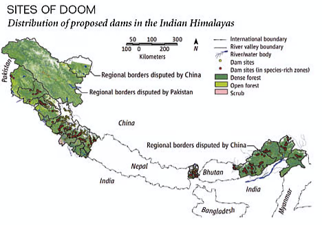
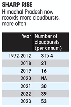
HIMALAYAS FRAGILITY
Why in news : The Himalayan Region, prone to cloudbursts and extreme weather events, is experiencing accelerated impacts of Global Warming.
About :
The Himalayas, a young and tectonically active mountain system, exhibit acute fragility due to:
- Geodynamic Sensitivity – Ongoing continental collision (Indian-Eurasian plates) triggers frequent seismicity, landslides, and destabilization.
- Glacial Retreat – Climate change accelerates ice melt, increasing GLOF (Glacial Lake Outburst Flood) risks (e.g., Kedarnath 2013).
- Anthropogenic Stress – Deforestation, infrastructure projects (e.g., Char Dham Highway), and tourism degrade slope stability, amplifying disaster vulnerability.
Fragility of the Himalayas: Changing Perception and Paradigm Shift over the Last 5 Decades
Paradigm Shift: From Natural Fragility to Socio-Ecological Fragility
|
Earlier Understanding (1970s–1990s) |
Current Paradigm (2000s–2020s) |
|
Focus on seismicity, slope failure, and glacial dynamics |
Emphasis on combined human-induced stress and climate change impacts |
|
Viewed fragility as natural limitation |
Viewed as socio-ecological outcome of development choices |
|
Isolated hazards (e.g., landslides) |
Systemic vulnerabilities (e.g., cascading disasters) |
|
Structural solutions like check dams |
Ecosystem-based, climate-resilient, and community-inclusive strategies |
Factors Aggravating Himalayan Fragility in the Last 5 Decades
1. Unplanned Urbanization & Tourism Boom
- Massive construction of roads, hotels, and hydropower projects without geological assessments.
- Case: Joshimath sinking (2023) in Uttarakhand due to land subsidence and heavy infrastructure on old landslide debris.
- Tourist influx in Himachal Pradesh rose from ~1 million in 1980s to over 17 million in 2022, stressing ecosystems.
2. Hydropower and Linear Infrastructure Projects
- Over 400 hydroelectric projects are planned/operational in Indian Himalayas.
- The construction of the Char Dham highway and Atal Tunnel has led to slope destabilization.
- Fragmentation of mountain rivers and loss of natural sediment flow (e.g., Alaknanda and Bhagirathi).
3. Climate Change and Glacier Retreat
- Himalayan glaciers are melting at double the rate since 2000 (ICIMOD, 2023).
- Example: Chamoli flash flood (2021) triggered by a glacial lake outburst, killing 200+ people.
- Rising frequency of GLOFs, avalanches, and extreme rainfall events.
4. Deforestation and Land-Use Change
- Forest cover in ecologically sensitive areas replaced by pine monoculture and urban expansion.
- Decline in traditional land-use practices like terrace agriculture and agroforestry.
- Depletion of watershed capacity in areas like Kangra, Tehri, and Almora.
5. Geopolitical and Military Pressures
- Strategic infrastructure near LAC (India-China) has increased construction and blasting in geologically sensitive zones.
- Expansion of roads and helipads in Ladakh and Arunachal Pradesh causing ecological stress.
Evidence of Intensifying Fragility
- Landslides have increased: From 0.2/km² (1970s) to over 0.9/km² in some Uttarakhand districts.
- Temperature rise: Average rise of ~0.3–0.4°C/decade in mid-Himalayan belt (MoEFCC data).
- Water stress: Springs that supported 50 million people are drying (NITI Aayog Himalayan Spring Atlas, 2020).
Himalayan Fragility to Environmental Principles & Ecology
|
Ecological/Environmental Principle |
How It Links to Himalayan Fragility |
|
Gaia Hypothesis |
Human-induced imbalance in natural systems like glacier-lake interaction |
|
Precautionary Principle |
Ignoring risk assessments in road and dam projects |
|
Carrying Capacity |
Tourism and settlement pressures exceeding sustainable limits |
|
Ecosystem Services Loss |
Forest degradation, reduced water retention, increased landslides |
|
Tragedy of Commons |
Overuse of alpine meadows, springs, and forests |
|
Ecological Resilience |
Fragile system nearing tipping points under cumulative stress |
|
Environmental Justice |
Disproportionate impacts on mountain communities |
Nature Based Solution to Reduce Risk in Himalayas
1. Eco-restoration of Native Forests
- Restore degraded slopes using indigenous species (e.g., Oak instead of Pine).
- Impact: Reduces soil erosion, enhances slope stability, improves water recharge.
- Example: JICA-funded forest restoration in Uttarakhand improved catchment resilience.
2. Spring-shed Management
- Protect and recharge natural springs using trenches, check dams, and native vegetation.
- Impact: Prevents water stress, supports rural livelihoods, reduces landslide-prone dryness.
- Example: Himmothan project (Uttarakhand) revived 360+ springs.
3. Agroforestry & Sloping Land Agriculture
- Promote tree-based mixed farming on slopes to prevent runoff and maintain soil fertility.
- Impact: Stabilizes land, diversifies income, reduces disaster risk.
- Example: Kumaon agroforestry models reduced topsoil erosion by ~60%.
4. Ban on Construction in Eco-sensitive Zones
- Enforce zoning laws and buffer zones using ecological risk mapping.
- Prevents infrastructure-induced hazards.
- Example: SC order on Char Dham project called for ecological safeguards.
5. Riverbank Bioengineering
- Use vetiver grass, willow, and bamboo to stabilize riverbanks instead of concrete.
- Impact: Controls erosion and floods.
- Example: Teesta riverbank stabilization using bioengineering in Sikkim.
6. Community-based Disaster Risk Reduction (CBDRR)
- Train local communities in risk mapping, early warning, and ecosystem protection.
- Impact: Builds local resilience and reduces post-disaster recovery time.
- Example: EcoTask Forces in Sikkim and Uttarakhand.
Government Initiatives Related to the Himalayas
National Mission on Sustaining Himalayan Ecosystem (2010)
- Encompasses 11 Himalayan states and 2 UTs (J&K and Ladakh).
- A mission under NAPCC, focusing on conserving biodiversity, traditional knowledge, and addressing climate vulnerability in the region.
Indian Himalayas Climate Adaptation Programme (IHCAP)
- Enhances climate resilience of Himalayan communities.
- Strengthens institutional capacities in glaciology and climate science, supporting evidence-based adaptation strategies.
SECURE Himalaya Project
- Part of the Global Wildlife Program funded by GEF.
- Aims at sustainable management of alpine meadows, forests, and combating wildlife crime in high-altitude ecosystems.
Mishra Committee Report (1976)
- Investigated Joshimath land subsidence; led by M.C. Mishra.
- Recommended bans on heavy construction, blasting, excavation, and tree felling to protect fragile terrain.
Conclusion
- Erratic monsoon and extreme events highlight urgent climate action needs.
- Prioritising adaptation, mitigation, renewable energy, and disaster resilience is crucial to safeguard Himalayan and subcontinental ecosystems.
Where to use :
Paper II ( Geography Optional ) : High Altitude Hazards
Paper III ( General Studies ) : Disaster Management
MASSIVE BLACK HOLE MERGER DETECTED
Why in news : An international team of scientists has detected the most massive black hole merger ever observed. The event, named GW231123, was observed by the LIGO-Virgo-KAGRA (LVK) collaboration, which forms the Gravitational Wave Network.
About :
The event GW231123, detected on November 23, 2023, by the LIGO–Virgo–KAGRA collaboration, marks a turning point in our understanding of cosmic geography. At its core, this event was a black hole merger—where two massive stellar remnants, one of ~140 M☉ and the other ~100 M☉, coalesced into a supermassive 225 M☉ black hole, releasing intense gravitational waves that traveled 12 billion light-years to reach Earth.
1. Spatial and Physical Dynamics of a Black Hole Merger
In astrophysical geography, black holes serve as gravitational sinks, shaping the morphology of galactic structures and influencing interstellar dynamics. The merger process is a manifestation of:
- Spatial convergence: Two distinct massive bodies spiraling inward due to energy loss from gravitational wave emission.
- Spatiotemporal distortion: The merger perturbs the fabric of spacetime, much like tectonic forces shape the Earth's lithosphere.
- Energy redistribution: Analogous to seismic energy dispersal, the event emitted gravitational energy across the cosmos, detectable only through advanced observatories.
2. Violation of the “Mass Gap”: A Challenge to Equilibrium Theory
From a systems perspective, the discovery challenges the stellar equilibrium model. According to the pair-instability theory, black holes between 60–130 solar masses shouldn't form via traditional stellar collapse. Yet, GW231123 violated this ‘mass gap’, suggesting:
- Hierarchical Mergers: The merging black holes may have themselves been formed from earlier mergers—hinting at a multi-generational cosmic lineage, akin to composite landform evolution in geomorphology.
- Non-linear evolution: Echoes the unpredictability found in complex Earth systems, like river piracy or abrupt climatic tipping points.
3. Relevance to Gravitational Geography and Geoscientific Paradigms
This event enriches a growing field sometimes termed “gravitational geography”—where the distribution and movement of cosmic masses are studied in terms of their spatial configuration, energy interactions, and temporal evolution.
Much like geographers study the spatial behavior of Earth's landforms under tectonic stress, this event prompts:
- Revision of stellar life cycle models, just as neotectonic studies revise our understanding of landscape evolution.
- Global collaboration in data gathering and modeling—paralleling Earth system science's integrative approach.
4. Way Forward: Geo-cosmic Intersections
|
Pathway |
Geo-Analogy |
Implication |
|
Astrophysical revisions |
Plate tectonic reconfigurations |
Reworking collapse models and black hole mass thresholds |
|
Expanded observation |
Remote sensing in dynamic terrains |
Multi-detector, real-time observation of space-time events |
|
Global cooperation |
Transboundary watershed governance |
Joint missions like the Einstein Telescope or Cosmic Explorer |
|
AI Modeling |
Predictive climatic modeling |
Need for AI-assisted waveform decoding from high-energy events |
Conclusion
The GW231123 event is not merely a celestial milestone—it reflects the fluidity and unpredictability of spatial systems, whether terrestrial or cosmic. For geography as a discipline, this underlines the value of systemic, spatial-temporal thinking in decoding both planetary and universal processes. It also reinforces the idea that just as Earth’s landscapes evolve through hidden forces, so too does the cosmos, whispering through the fabric of space-time.
Where to Use :
Paper I ( General Studies ) : Universe and Solar System
Source :
BIOSTIMULANTS - 24 july 2025
Biostimulants : Biostimulants are natural or synthetic substances applied to plants or soil to enhance nutrient uptake, improve stress tolerance (e.g., drought, salinity), and boost overall crop productivity. Unlike fertilizers, they do not supply nutrients directly but activate plant metabolic processes. Examples include humic acids, seaweed extracts, and beneficial microbes, making them vital for sustainable agriculture and climate-resilient farming.
Flue Gas Desulphurisation
Flue Gas Desulphurisation : FGD is a technology used in thermal power plants to remove sulfur dioxide (SO₂) from flue gases before they are released into the atmosphere. This is crucial for reducing acid rain and air pollution. The process typically involves spraying a limestone or lime slurry into exhaust gases, forming gypsum as a byproduct. FGD is mandated under India’s environmental norms for cleaner coal-based energy production.
Cat bonds
Cat bonds : Cat bonds are risk-linked financial instruments that transfer catastrophe-related risks (like earthquakes, floods, or cyclones) from insurers to capital market investors. If a disaster meets predefined criteria, the bondholder may lose part or all of their principal, which is then used for disaster recovery. These bonds provide emergency funds and are increasingly relevant for climate risk financing in vulnerable regions.
Tipping Point
Tipping Point : A climate tipping point refers to a critical threshold in the Earth’s system beyond which rapid, irreversible changes occur, such as ice sheet collapse or Amazon rainforest dieback. Crossing such a point accelerates global warming and destabilizes ecological and human systems. Current concerns include Arctic sea ice loss and coral reef collapse, highlighting the urgency for climate action to avoid cascading impacts.
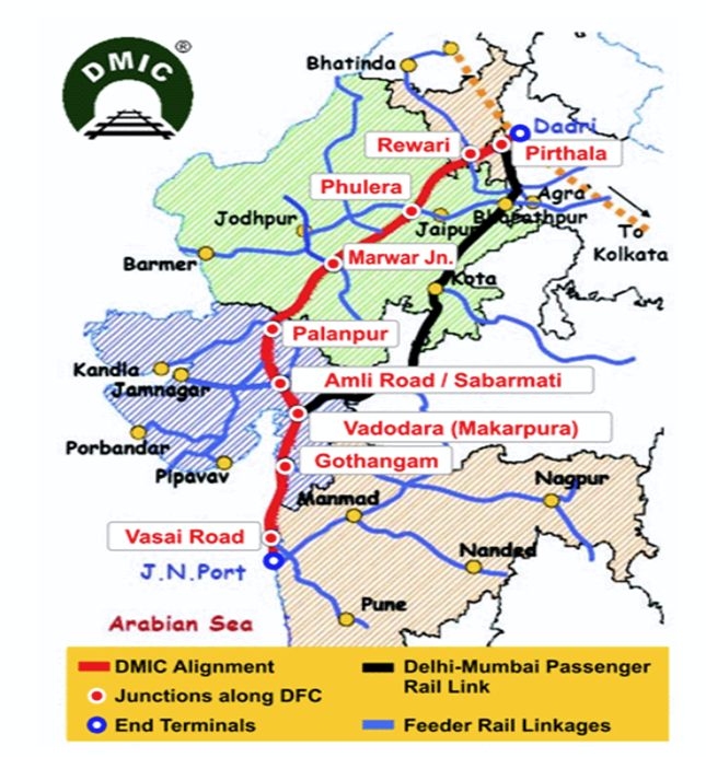
DELHI MUMBAI INDUSTRIAL CORRIDOR AND REGIONAL PLANNING
Delhi-Mumbai Industrial Corridor (DMIC) is one of the largest infrastructure projects in India, aimed at developing new industrial cities as "Smart Cities" and expanding manufacturing and services. It spans six states: Uttar Pradesh, Haryana, Rajasthan, Madhya Pradesh, Gujarat, and Maharashtra.
- Length: ~1,504 km
- Coverage: Over 24 industrial nodes across 8 investment regions and 13 industrial areas.
- Investment: Over ₹1,00,000 crore (US$12 billion) projected in the initial phase.
- Partnership: Jointly developed by the Government of India and Japan (Japan Bank for International Cooperation - JBIC).
- Created 24 new townships and smart cities like Dholera (Gujarat) and Shendra-Bidkin (Maharashtra).
- Job creation: 3 million+ direct and indirect employment opportunities.
- Catalyzes growth in backward regions of Rajasthan and Madhya Pradesh.
- Land acquisition issues in Rajasthan and Maharashtra due to resistance from farmers.
- Water stress concerns in arid zones; Dholera requires extensive water management planning.
- Regional disparities asl development creates uneven growth zones.
Where to use :
Paper II ( Geography Optional ) : Industrial Corridor and Regional Planning
Places in News - 24 July 2025
1. Pakyong
Why in news : Yakten, a village in Sikkim’s Pakyong district, has been officially declared India’s first digital nomad village under the ‘Nomad Sikkim’ initiative.
About :
- Pakyong got its name from the lepcha word "pa yong" meaning "bamboo of the bow”.
- It is located in East Sikkim at an altitude of 1700m (5577 ft) with hilly topography and a good agricultural area.
- The "National Research Centre for Orchids" (ICAR Institute) is also located here.
- Pakyong lies on National Highway-717A connecting Bagrakote to Gangtok via Labha, Algarah.
- Approx : East Sikkim
2. Chandipur
Why in news : India has successfully test-fired its indigenously developed ballistic missiles Prithvi-II and Agni-I from the Integrated Test Range in Chandipur, Odisha.
About :
- Chandipur is a resort town in Balasore District, Odisha, India.
- The town is located on the shore of Bay of Bengal and is approximately 16 kilometers from Balasore Railway Station.
- Chandipur beach is unique in a way that the water recedes up to 5 kilometers during the low tide.
- It is also the location of DRDO's only missile testing lab,
- Approx : Balasore
3. Ranthambhore TIger Reserve
Why in news : India is building its first large-scale animal overpasses on the Delhi-Mumbai Expressway under the Bharatmala Pariyojana, allowing wildlife to cross safely through the Ranthambore Tiger Reserve’s (RTR) buffer zone.
About :
- It is a national park in the Indian state of Rajasthan.
- It covers a total area of 1,334 km2 (515 sq mi).
- It is bounded to the north by the Banas River and to the south by the Chambal River.
- It is named after the historic Ranthambore Fort, which lies within the park.
- The ecoregion includes Khathiar-Gir dry deciduous forests.
- Approx : Sawai Madhopur
4. Mahisagar River
Why in news : The collapse of the Mahisagar River Bridge in Vadodara due to structural failure, killing 20 people, highlights growing concerns over infrastructure quality amid similar incidents nationwide.
About :
- Mahisagar or Mahi River is one of the few west-flowing rivers in peninsular India, revered for its cultural and ecological significance.
- Origin: Near Minda village in Dhar district, Madhya Pradesh
- States It Flows Through: Madhya Pradesh, Rajasthan, and Gujarat.
- Empties into: Arabian Sea via the Gulf of Khambhat.
- Major Dams on Mahi River: Mahi Bajaj Sagar Dam (Rajasthan), Kadana Dam (Gujarat), and Wanakbori Weir.
- Intersects the Tropic of Cancer twice — a rare geographic occurrence unique to Indian rivers.
5. Wular Lake
Why in news : After three decades of ecological dormancy caused by the 1992 flood, lotus flowers have once again begun blooming in Kashmir’s Wular Lake due to focused conservation efforts led by Wular Conservation and Management Authority (WUCMA).
About :
- Situated in Bandipore district of Jammu & Kashmir, approximately 50 km northwest of Srinagar.
- Fed by the Jhelum River, playing a vital role in the hydrology of the Kashmir Valley.
- Formed due to tectonic activity and believed to be a remnant of the ancient Satisar Lake.
- It is the largest freshwater lake in India and the second largest in Asia, spanning 200 sq. km
- Approx : Bandipore

Fortnightly KOSMOS MCQs Practice - 24th July 2025
Q1. Consider the following statements regarding the Mhadei Wildlife Sanctuary:
1. It has been recognized as an International Bird Area due to the presence of various bird species, including the Malabar parakeet and Rufous babbler.
2. The Netravati River flows through the sanctuary.
Which of the statements given above is/are correct
- Only 1
- Only 2
- Both 1 and 2
- Neither 1 nor 2
Q2. Consider the following statements regarding Similipal National Park:
1. Similipal has been included in UNESCO's Biosphere Reserves list since 2009 and was declared a tiger reserve under Project Tiger.
2. Its rivers provide a habitat for Gharials.
Which of the statements given above is/are correct
- Only 1
- Only 2
- Both 1 and 2
- Neither 1 nor 2
Q3. Consider the following statements regarding Greenhouse Gas.
1. Carbon dioxide (CO₂) is the most prevalent greenhouse gas in the atmosphere.
2. Methane (CH₄) is primarily emitted from livestock farming and landfill sites.
3. Industrial fluorinated gases have a much lower Global Warming Potential (GWP) compared to carbon dioxide (CO₂).
Select the correct answer using the code given below:
- 1 and 2 only
- 2 only
- 1 only
- 1, 2 and 3
Q4. 30 by 30 target sometimes seen in news is related to which of the following?
- Reducing carbon emissions by 30% by 2030.
- Increasing the number of electric vehicles on roads by 30% by 2030.
- Protecting 30% of the earth’s land and oceans by 2030.
- Achieving 30% renewable energy in the global energy mix by 2030
Q5. Cryptobiosis, recently in the news, is related to which of the following?
- process in which organisms harness light to produce energy despite a lack of nutrients.
- A novel blockchain technology designed for secure transactions involving living modified organisms.
- A technique where plants are genetically modified to enhance their resistance to pests.
- A metabolic condition that enables organisms to endure extreme environmental conditions.
Q6. Consider the following statements:
1. The Sun shows differential rotation, with its equator completing a rotation in about 25 days, while the poles take approximately 35 days.
2. The chromosphere is a thin layer of plasma situated between the Sun's visible surface and its outer atmosphere.
Which of the statements given above is/are correct?
- Only 1
- Only 2
- Both 1 and 2
- Neither 1 nor 2
Q7. Consider the following statements:
1. Reduce pesticide-related risks by 50% by 2030.
2. Address climate change using nature-based solutions.
3. Restore 30% of degraded ecosystems worldwide by 2030.
How many of the above is/are key goals of the Kunming-Montreal Global Biodiversity Framework?
- Only one
- Only two
- All three
- None
Q8. Consider the following statements:
1. The Infrastructure for Resilient Island States (IRIS) initiative, launched at COP21 in Paris, seeks to help Small Island Developing States (SIDS) attain sustainable development.
2. In 2022, the Infrastructure Resilience Accelerator Fund (IRAF) was created with the backing of the United Nations Development Programme and the United Nations Environment Programme.
Which of the statements given above is/are correct?
- Only 1
- Only 2
- Both 1 and 2
- Neither 1 nor 2
Q9. Consider the following statements:
1. The tailless Hoolock Gibbon is the only ape species native to India.
2. The Western Hoolock Gibbon, found across all northeastern states, is classified as Endangered on the International Union for Conservation of Nature's Red List.
Which of the statements given above is/are correct?
- Only 1
- Only 2
- Both 1 and 2
- Neither 1 nor 2
Q10. Consider the following statements related to Millets:
1. De-branning makes millets softer but decreases their shelf life.
2. Millets are rich in bioactive flavonoids.
3. India is the top producer and exporter of millets.
How many of the above statements is/are correct?
- Only one
- Only two
- All three
- None
Share the article
Edukemy’s Current Affairs Quiz is published with multiple choice questions for UPSC exams
MCQ
Get Latest Updates on Offers, Event dates, and free Mentorship sessions.

Get in touch with our Expert Academic Counsellors 👋
FAQs
Geography Current Affairs focuses on the contemporary issues, events, and developments in the field of geography. It covers recent geographical phenomena, environmental changes, geopolitical shifts, and related news. This differs from regular geography studies which may focus more on foundational concepts, historical contexts, and theoretical frameworks.
Updates are provided regularly to ensure that subscribers stay informed about the latest developments in geography. Typically, updates are provided on a fortnightly basis, depending on the frequency of significant events and changes in the field.
Absolutely. Geography Current Affairs serves as a valuable resource not only for Geography optional but also for GS papers, especially GS Paper 1 (covering Indian Heritage and Culture, History, and Geography of the World and Society) and GS Paper 3 (covering Technology, Economic Development, Biodiversity, Environment, Security, and Disaster Management). It aids in building a holistic understanding of various topics and strengthens answer-writing skills by incorporating contemporary examples and perspectives.
Geography Current Affairs holds immense importance for UPSC preparation, particularly for aspirants opting for Geography optional. It helps candidates stay updated with the latest developments, geographical phenomena, environmental issues, and geopolitical shifts worldwide, aligning them with the dynamic nature of the subject as tested in the UPSC examinations.