26 Feb
Disasters in India & Disaster Risk Management
In News
First responders for disaster management to be set up in 350 districts in India.
Background
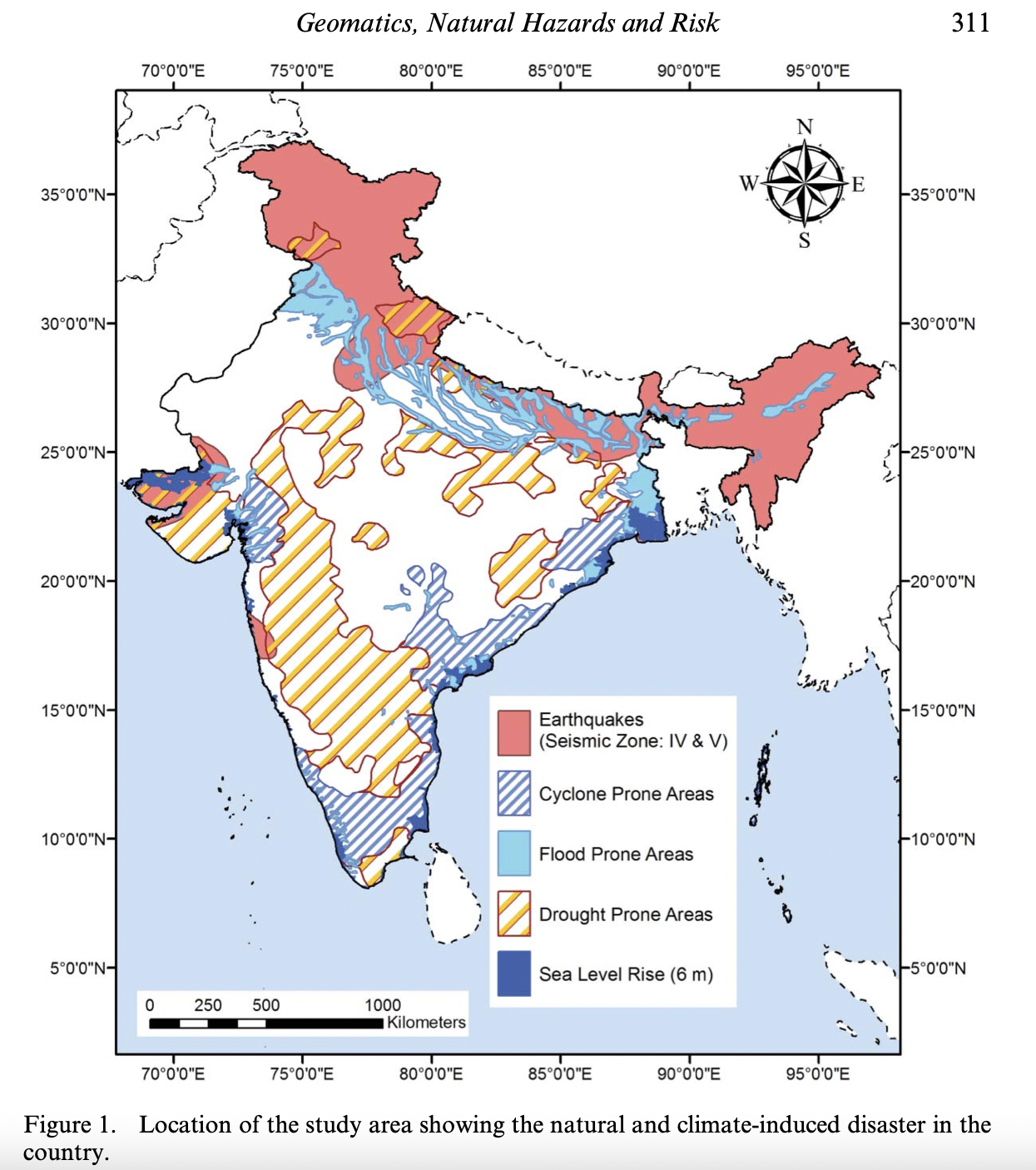
- As per India’s National Policy on Disaster Management, India is one of the most disaster-prone countries in the world. The locational and geographical features render it vulnerable to several natural hazards such as cyclone drought, floods, earthquakes, fire, landslides, and avalanches.
- India is among the world’s most disaster-prone countries with 27 of its 29 states and seven union territories exposed to recurrent natural hazards such as cyclones, earthquakes, landslides, floods, and droughts.
- The high population density combined with poor preparedness, planning and management, and rescue and relief measures inevitably lead to huge losses of lives and property every year in the country.
- Climate change and environmental degradation have further compounded the frequency and intensity of disasters along with increasing the vulnerability of key assets including people. In addition, almost one third of the country is also affected by civil strife.
- Disaster proneness in India: Almost 58.6 per cent of the landmass is prone to earthquakes of moderate to very high intensity; over 40 million hectares (12 per cent of land) are prone to floods and river erosion; of the 7,516 km long coastline, close to 5,700 km is prone to cyclones and tsunamis; 68 per cent of the cultivable area is vulnerable to drought and hilly areas are at risk from landslides and avalanches.
Reasons associated with regional vulnerability of disaster in India
- The natural geological setting of the country is the primary basic reason for its increased vulnerability.
- The geo-tectonic features of the Himalayan region and adjacent alluvial plains make the region susceptible to earthquakes, landslides, water erosion, etc.
- The tectonic features, characteristics of the Himalaya are prevalent in the alluvial plains of Indus, Ganga and Brahmaputra too, as the rocks lying below the alluvial pains are just extension of the Himalayan ranges only. Thus, this region is also quite prone to seismic activities. As a result of various major river systems flowing from Himalaya and huge quantity of sediment brought by them, the area is also suffering from river channel siltation, resulting into frequent floods, especially in the plains of Uttar Pradesh and Bihar.
- The disturbance in the pressure conditions over oceans, results into cyclones in coastal regions.
- The Geo-tectonic movements going on in the ocean floor make the coastal region prone to tsunami disaster too.
- Though peninsular India is considered to be the most stable portions, but occasional earthquakes in the region shows that geo- tectonic movements are still going on within its depth.
- The extreme weather conditions, huge quantity of ice and snow stored in the glaciers, etc. are other natural factors which make the country prone to various forms of disasters.
- Along with the natural factors discussed in the preceding text, various human induced activities like increasing demographic pressure, deteriorating environmental conditions, deforestation, unscientific development, faulty agricultural practices and grazing, unplanned urbanization, construction of large dams on river channels etc. are also responsible for accelerated impact and increase in frequency of disasters in the country.
Consequence of disaster in India
- Loss of infrastructural property: there is devastating loss of infrastructure, like roads, buildings, social infrastructure like schools and hospitals, bridges, dams etc when a disaster of high intensity strikes them.
- For example: the towns of Bhuj, Bhachau, Anjar, Gandhidham, and Ratnal were completely destroyed by the earthquake which struck Bhuj on 26th January 2001.
- Food insecurity: According to Food and Agriculture Organization, the impact of disasters on agriculture and food security reveals that disasters can cause considerable damage to physical agricultural assets.
- They destroy standing crops, irrigation systems, livestock shelters, veterinary services, and aquaculture equipment and hatcheries.
- The post-production infrastructure such as storage facilities, processing, marketing and transport, buildings, farm equipment, and cooperatives get impaired to a great extent.
- These lead to a decline in output from the crop, livestock, fisheries, aquaculture, and forestry production.
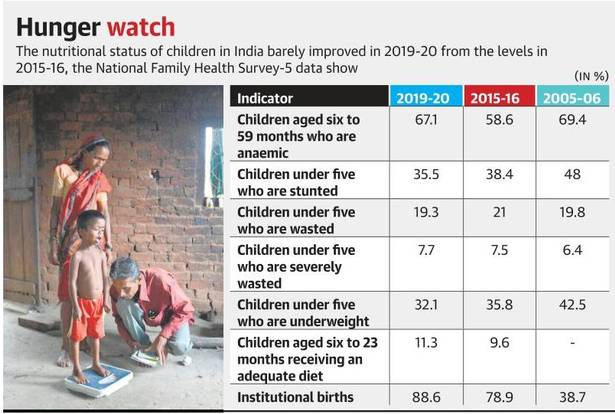
- The domino effect on the food value chain, agro-industries, imports and exports, and sector growth. This leads to poverty thereby increasing food insecurity and malnutrition.
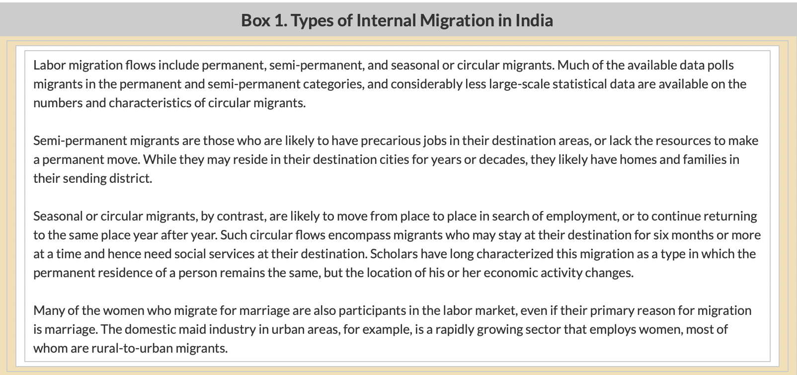
- Displacement of large groups of people: Disasters like drought, floods, landslides, earthquakes, wildfires, and tsunami have caused many to displace from their homes. In India, the rural population migrating to nearby cities after the severe drought is a common sight. Their livelihood is taken away and they have to make do with whatever work available in cities. This creates a burden on the resources of the cities also. Further, most of the displaced population get stagnated in the cities permanently. The problems faced by the displaced population include:
- Poor shelters and sanitation facilities
- Unsafe water
- Poor quality food which leads to malnutrition
- Loss of property and fear of future
- Experiencing trauma and depression
- Women and children needing better protection
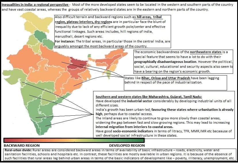
- Loss of important documents to ascertain the identity needed to receive aid. This leads to poor quality of life and livelihood opportunities, aggravating regional inequalities and disparities.
- Alter demographic profile of the region: Over the last few decades, millions of people got killed by natural disasters. Apart from a million deaths, its aftereffects on people linger. Also, the lives of billions of people were severely affected. But there are also other diseases which threaten the world.
- Communicable diseases spread immediately after each disaster more due to population displacement.
- Diarrheal disease outbreak due to contaminated water occurs after a flood.
- The cholera epidemic is also common.
- Hepatitis A and E are also transmitted due to a lack of access to safe water and sanitation.
- Topographical changes: the main effects of disasters, like earthquake, on topographical features are seen in the form of offsets along known faults, fissures, scarp elevations, depressions etc.
- For instance: cracks and fissures occur because of severe earthquake facilitate landslides, earth avalanches, slump etc.
Disaster management in India
- Institutional framework
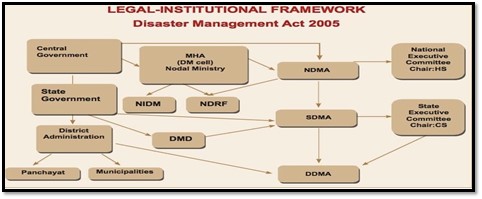
Initiatives taken for Disaster Management and Mitigation:
- Disaster Management Act, 2005: provides for the effective management of disaster and provides institutional mechanisms for drawing up and monitoring the implementation of the disaster management. The Act also ensures measures by the various wings of the Government for prevention and mitigation of disasters and prompt response to any disaster situation.
- The National Disaster Management Plan, 2019 provides a framework and direction to the government agencies for all the phases of the disaster management cycle. It is in accordance with the provisions of the Disaster Management Act, 2005 and the guidance given in the National Policy on Disaster Management (NPDM) 2009. The plan is identified as a “dynamic document,” which is to be periodically improved, keeping up with the emerging global best practices and knowledge base in disaster management. It focuses on building disaster resilience.
- NDMA Guidelines: NDMA is engaged in the formulation of guidelines through a consultative process involving multiple stakeholders, including the government, non-government organizations, academic and scientific institutions, the corporate sector, and community. Since its inception, NDMA has so far released various disaster specific and thematic guidelines such as:
- Management of Landslide and Snow Avalanches
- Management of Cyclones
- Management of Earthquake
- Management of Floods
- Chemical Disasters (Industrial)
- National Cyclone Risk Mitigation Project: The scheme aims to upgrade cyclone forecasting, tracking, and warning systems, build capacity in multi-hazard risk management and to construct major infrastructures including multi-purpose cyclone shelters and embankments.
Way forward
Understanding regional geomorphology and gaining geomorphic knowledge helps in the identification, prediction and assessment of probable effects and management of natural geomorphic hazard. For instance: geomorphic knowledge of behavior of river system and its morphological characteristics like channel geomorphology, channel geometry, channel pattern etc, may help in controlling river flood through several flood control measures like
- To delay the return of runoff resulting from torrential rainfall to rivers,
- To hasten discharge of water,
- To divert water flow through diversion channel etc.
Sources:
Sweet Revolution in India
In News
As part of the Sweet revolution, KVIC launched the country’s first Mobile Honey Processing Van at Village Sirora in Ghaziabad, UP recently.
Background
- Sweet revolution is an ambitious initiative of the Government of India, which is aimed at promoting apiculture, popularly known as ‘beekeeping’, for accelerating the production of quality honey and other related products.
- The demand for good quality honey has grown over the years as it is considered a naturally nutritious product. Other apiculture products such as royal jelly, beeswax, pollens, etc., are also used extensively in different sectors like pharmaceuticals, food, beverage, beauty, and others.
- Scaling up beekeeping will double farmers’ income, generate employment, ensure food security and bee conservation, and increase crop productivity and pollination.
- To provide a booster shot to Sweet Revolution, the government launched the National Beekeeping and Honey Mission, for the overall promotion and development of scientific beekeeping in mission mode.
Sweet revolution prospects in India
As the diversified agro climatic conditions in India provide great potential and opportunities for beekeeping/honey production, India is among the world’s top five honey producers. According to the Economic Survey, the export of honey has increased by about 110 per cent between 2013-14 to 2019-20.
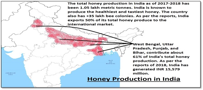
Benefits of apiculture in India
- Promote sustainable agriculture: Honeybees are vital in sustaining plant bio-diversity and also improves yields of crops by cross-pollination. This increase has been shown to be in the range of 5 to 3000% depending upon the type of crop.
- The ecological importance of bees in crop pollination and the preservation of the biodiversity of both flora and fauna are unquestionable. Pollination is a valuable ecosystem service for the production of fruits, vegetables, cotton, and oilseed crops among many other agricultural crops.
- Honeybees are the single most important insect pollinator species for the diverse crop yield, both quantitatively and qualitatively. Thus, assure crop yields and helping maintaining plant biodiversity in natural ecosystems.
- Promote rural region development:
- Like dairying, apiculture is also practiced mostly by marginal and landless farmers. Small and marginal holders face several problems in agriculture like small and fragmented land holdings, shortage of good quality seeds, problem of irrigation, lack of mechanization, etc. These factors make agriculture economically unviable for small holders. However, small scale agriculture can be made profitable through product diversification and entrepreneurship.
- Beekeeping is an agro-based activity which is being undertaken as an integrated farming practice. It supplements income & employment generation and nutritional intake of rural population.
- Beekeeping can contribute effectively to the empowerment of disadvantaged people and communities and makes a multifaceted contribution to rural livelihoods.
- Development of primary industries and regional development: Apiculture can emerge as a potential agricultural enterprise in accelerating the growthof economy. Apiculture produces wide range of products such royal jelly, bee toxin, pollen and propolis, which have a very high demand in international markets. Developing primary and small scale industries in backward regions such as hill regions, dry land regions, etc, can minimize disparities in the level of development as observed in differential access to resources and differences in the economic structure and social transformation.
Way Forward
Bibek Debroy led beekeeping development committee has made following recommendations to enhance the contribution of the beekeeping sector for achieving the target of doubling of farmer incomes by 2022
- Institutionalizethe National Bee Board and rename it as the Honey and Pollinators Board of India as it will help in advancing beekeeping through multiple mechanisms such as by creating an integrated bee development centers, Creating a honey price stabilization fund, data collection et
- Beekeeping should not be restricted to honey and wax only, instead marketing of bee products such as pollen, propolis, royal jelly, and bee venom etc should be done.
- Recognition of apiculture as a subjectfor advanced research under the aegis of Indian Council for Agricultural Research.
- Recognize honeybees as inputs to agricultureand consider landless beekeepers as farmers.
- Training and developmentof beekeepers should be provided by state governments.
- National and regional infrastructureshould be developed for storage, processing, and marketing of honey and other bee products.
- Plantation ofbee-friendly flora at appropriate places and engaging women self-help groups in managing such plantations.
Sources:
Threats to Western Ghats
In News
Mindless construction in the Western Ghats and the Himalayas is worsening climate disasters, ecologist Madhav Gadgil said in an interview.
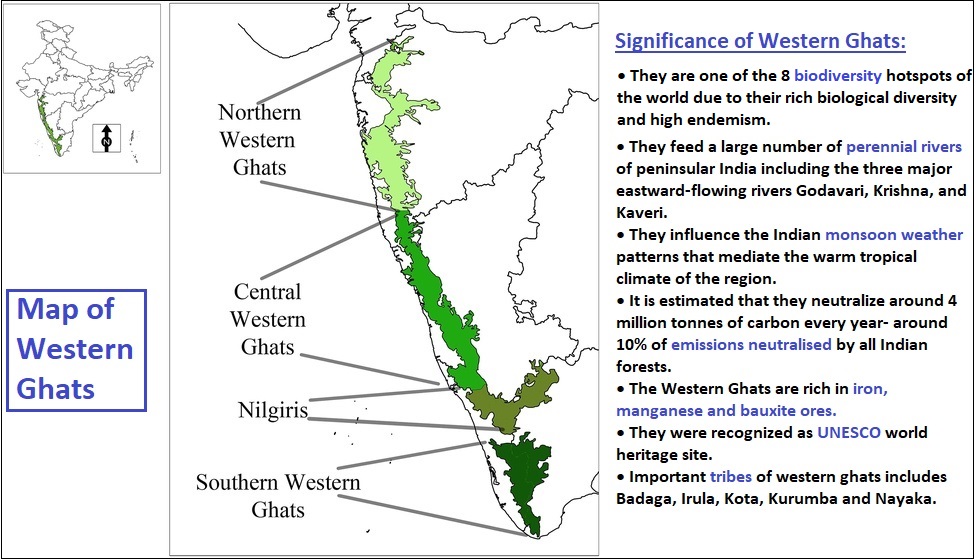
Major threats faced by Western Ghats
- Unchecked mining: With a steep increase in iron ore prices and demand for lower grade ores, mining activities have grown rapidly especially in Goa and often in violation of all laws, resulting in serious environmental damage and social disruption.
- Sand mining has emerged as a major threat in Kerala. Unsustainable mining has increased vulnerability to landslides, damaged water sources and agriculture, thus negatively affected the livelihoods of the people living in those areas.
- Livestock grazing: Livestock grazing within and bordering protected areas by high densities of livestock (cattle and goats) is a serious problem because it causes habitat degradation. Growth in livestock densities often accompany human population growth, resulting in serious conflicts between villagers and forest department officials.
- Human-Wildlife conflict: Given that the Western Ghats exists within an intensely human-dominated landscape, human-wildlife conflicts are a common phenomenon. For example, villagers living close to Bhadra Wildlife Sanctuary in the State of Karnataka, lose approximately 11 percent of their annual grain production to raiding elephants annually (CEPF).
- Extraction of forest produce: Human communities living within and adjacent to protected areas in the Western Ghats are often dependent on extraction of NTFPs to meet a diversity of subsistence and commercial needs. With rising population and changing consumption patterns, sustainability of NTFP is a critical issue.
- Encroachment by human settlements: Human settlements where legal and/or traditional rights of land ownership occur both within and outside protected areas all across the Western Ghats and represent a significant landscape level threat.
- Plantations: Agroforestry systems in the Western Ghats are today dominated by tea, coffee, rubber and monocultures of various species, including the recently introduced oil palm. Over the years, plantations of cash crops have displaced extensive patches of natural forests throughout the Western Ghats and are frequently associated with encroachment of surrounding forest areas.
- Hydropower projects: Large dam projects in Western Ghats have resulted in environmental and social disruption despite cost benefit analyses and environmental impact assessments being done by the government and companies.
- Pollution: The unrestricted use of agrochemicals in the vicinity of forests, particularly in tea and coffee estates, causes serious damage to aquatic and forest ecosystems.
- Deforestation: Conversion of forest land into agricultural land or for commercial purpose like tourism, illegal logging for timber have had significant negative effects on biodiversity.
- Climate change: According to the Second National Communication on Climate Change (NATCOM, 2012), the Western Ghats is expected to experience increase in temperature regimes, rainfall and extreme events due to climate change.
- According to a research, Climate change in the next half a century could severely reduce the extent of suitable habitats for wildlife endemic to the Western Ghats, such as the Indian brown mongoose.
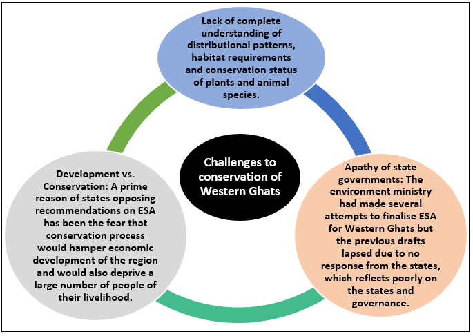
Committees for Western Ghats and their recommendations:

Way forward
- There is a need for better understanding of the role of biodiversity in ecosystem functions and related ecosystem services. This would also help in eliciting greater civil society support and enhanced political will to conserve the Western Ghats.
- Land use policy and law enforcement should ensure that illegal hunting, deforestation, land use change and other human actions that contribute to livelihoods but hamper biodiversity conservation are kept in check.
- There is a need for policy changes that promote better management of human-wildlife conflict, financial incentives to encourage biodiversity-friendly farming and other incentive schemes such as payments for ecosystem services.
- A balance between conservation efforts and development should be sought and concerned state governments should come to a consensus for implementation of ESA in Western Ghats.
Where it can be used?
It can be used in topics related to Paper 1 (problems of deforestation and conservation measures, environmental degradation, and environmental conservation), Paper 2 (Forest and wildlife resources and their conservation, Natural vegetation, Sustainable development) and GS 3 (Environmental degradation).
Sources:
Soil catena
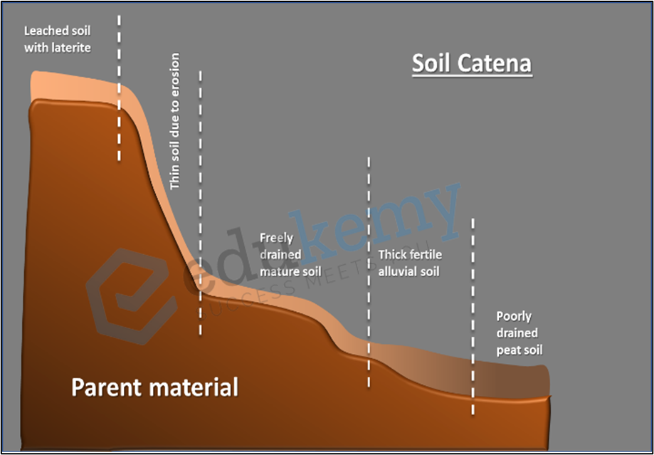
- A soil catena is a series of various soil profiles that run down a slope in a particular order.
- They are found on hill slopes with homogenous geology (same parent material) and little variance in climate from the top to the bottom of the slope.
- Scientist Geoffrey Milne coined the term catena to designate these soil-topography units.
- Changes in slope gradient are mostly responsible for differences in soil profile that occur down the slope.
- As the gradient increases, the depth of the soil will decrease.
- As the gradient rises, the moisture in the soil will decrease
- Where the gradient is lowest, soil acidity is highest, and leaching is most prevalent. In these areas, Terra Rossa soils can be found.
- Where the slope gradient is greatest and clay particles are most numerous, the soil texture will be sandier.
- Organic content will be highest where slope gradient is lowest and soil depth greatest.
- Thus, analysis of soil catena reflects the type of topography on which soil is formed and could help to understand the influence of soil hydrology on soil formation.
Source:
Altiplanation
It is a process of relief reduction or planation under periglacial conditions. It is found in periglacial regions of Greenland, Alaska, Norway, etc.
Features of Altiplanation
- Flattened submit and benches like features developed on higher altitude of spurs and hillsides due to altiplanation are called altiplanation terraces.
- These terraces are separated by scarps which range in height from 2m to 12m.
- Terraces are 10 to 90 m long and up to 800m wide.
- The angle of the scarps varies from 15° to 22°.
The process of altiplanation includes frost sapping, congelifraction and congelifluction. The terrace and having stones are called stone bank terraces. These terraces are the good examples of erosional surfaces.

Source:
Amphidromic Point
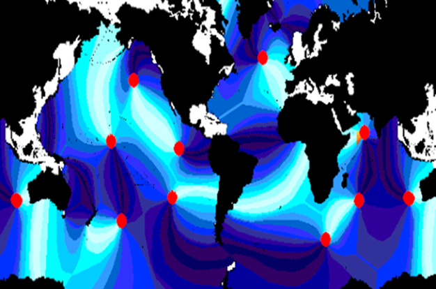
- An amphidromic point, also called a tidal node, is a geographical location which has zero tidal amplitude for one harmonic constituent of the tide.
- KELVIN WAVEs rotate around Amphidromic Point. The rotation is caused by the CORIOLIS FORCE acting on the flow induced by a standing tidal wave in large basins.
- Amphidromic points are approximately constant in location but may show seasonal or periodic variation.
- Knowledge of these location helps us to better understand the relation between tide/waves and the relief features. These points are taken into consideration while deciding the sea navigation route.


Sources:
Managing the Adverse Consequences of Drought, Syria
Background: The Eastern Mediterranean region is subject to frequent soil moisture droughts, and in areas where annual rainfall ranges between 120 to 400 mm, rain-fed crops are strongly affected.
Challenges faced by this region
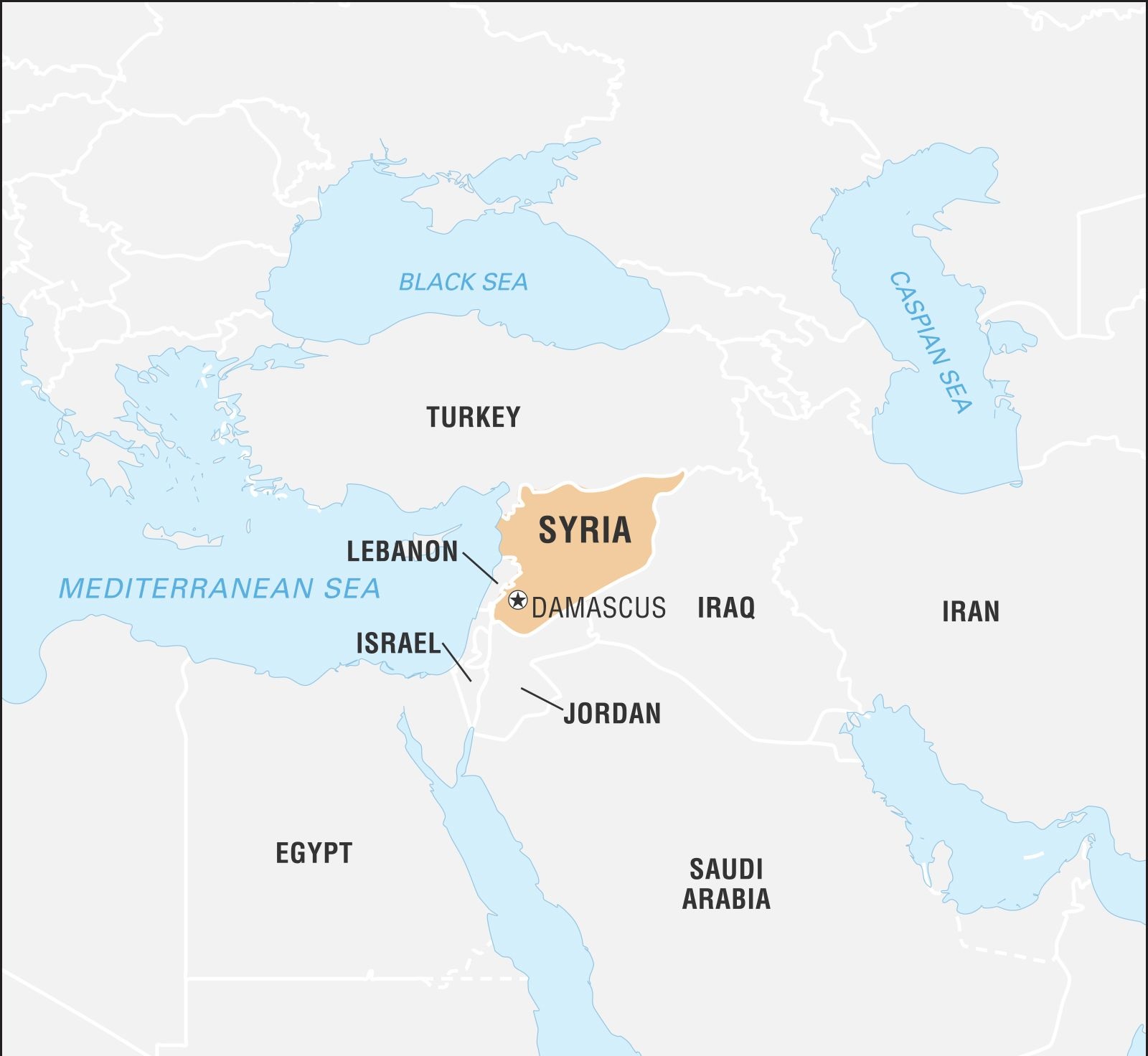
- Syria is considered to be a dry and semi-arid country. Three-quarters of the cultivated land depends on rainfall and the annual rate is less than 350 mm in more than 90% of the overall area.
- The prolonged drought has affected 1.3 million people, and the loss of the harvest has accelerated migration to urban areas and increased levels of extreme poverty.
- Of the farmers who depended on rain-fed production, most suffered complete or near-total loss of crops. Approximately 70% of the affected farmers in the rainfed areas have produced minimal to no yields because seeds were not planted due to poor soil moisture conditions or failed germination.
- Drought has affected the livelihoods of small-scale farmers and herders, threatening food security and having negative consequences for entire families living in affected areas.
- Herders in the region were reported to have lost around 80% of their livestock due to barren grasslands, and animal feed costs rose by 75%, forcing sales at 60 to 70% below cost.
- One of the most visible effects of the drought was the large migration of between 40,000 and 60,000 families from the affected areas.
Interventions to tackle the situation
The UN Syria Drought Response Plan was designed to address the emergency needs of, and to prevent further impact by protracted drought. The Response Plan identified as its strategic priorities the rapid provision of humanitarian assistance, the strengthening of resilience to future drought and climate change, and assisting in the return process and ensuring socioeconomic stability among the worst-affected groups. Syria also welcomed international assistance provided to the drought-affected population through multilateral channels. Various loans to those affected, including farmers and women entrepreneurs, were provided.
Outcomes/Consequences of the Interventions
These interventions were aimed at providing support through four main approaches:
- the rapid distribution of wheat, barley, and legume seeds to 18,000 households in the affected areas, potentially assisting 144,000 people;
- sustaining the remaining asset base of herders by providing animal feed and limited sheep restocking;
- the development of a drought early warning system to facilitate the government taking early actions before serious and significant losses occur and to develop this to ensure sustainability; and
- building capability to implement the national drought strategy by developing and addressing all stages of the disaster management cycle.
Conservation agriculture (which has been defined as no-tillage, direct drilling/seeding, and drilling/seeding through a vegetative cover) is considered to be a way forward for sustainable land use.
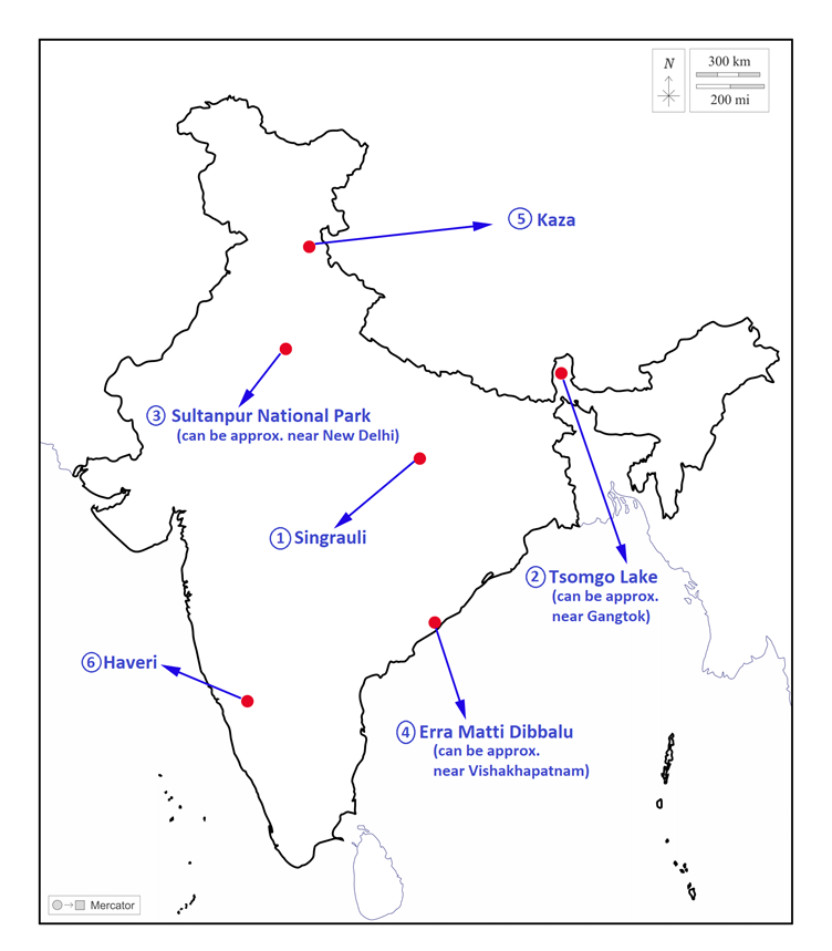
Places in news - Singrauli
|
Singrauli
|
|
Tsomgo Lake
|
|
Sultanpur National Park
|
|
Erra Matti Dibbalu
|
|
Kaza
|
|
Haveri
|
Share the article
Get Latest Updates on Offers, Event dates, and free Mentorship sessions.

Get in touch with our Expert Academic Counsellors 👋
FAQs
Geography Current Affairs focuses on the contemporary issues, events, and developments in the field of geography. It covers recent geographical phenomena, environmental changes, geopolitical shifts, and related news. This differs from regular geography studies which may focus more on foundational concepts, historical contexts, and theoretical frameworks.
Updates are provided regularly to ensure that subscribers stay informed about the latest developments in geography. Typically, updates are provided on a fortnightly basis, depending on the frequency of significant events and changes in the field.
Absolutely. Geography Current Affairs serves as a valuable resource not only for Geography optional but also for GS papers, especially GS Paper 1 (covering Indian Heritage and Culture, History, and Geography of the World and Society) and GS Paper 3 (covering Technology, Economic Development, Biodiversity, Environment, Security, and Disaster Management). It aids in building a holistic understanding of various topics and strengthens answer-writing skills by incorporating contemporary examples and perspectives.
Geography Current Affairs holds immense importance for UPSC preparation, particularly for aspirants opting for Geography optional. It helps candidates stay updated with the latest developments, geographical phenomena, environmental issues, and geopolitical shifts worldwide, aligning them with the dynamic nature of the subject as tested in the UPSC examinations.

