
02 Oct
Fertilizers misuse in Indian agriculture-Hazardous implications
Why in news: GoI is working on a plan to cap the number of subsidised fertiliser bags that individual farmers can buy in any cropping season to tackle the excessive use in agriculture.
The extent of fertilizer consumption and misuse in Indian agriculture:

Hazardous implications of fertilizer misuse:
- Deadly algal blooms: Transfer of excessive nutrients into water bodies through agricultural run-off leads to exponential growth of harmful algae in the water bodies. The abundance of algae uses up the oxygen in the water, the dies, floating to the surface as rotting green or red scum that is toxic and which further depletes water oxygen levels which is called ‘Eutrophication’. E.g. Researchers have found that the toxic algal blooms had increased by around 15% over the last 12 years in Indian seas due to agricultural run-off and sewage discharge.
- Loss of aquatic biodiversity: Eutrophication leads to rapid depletion of oxygen levels in the water and creates a very dangerous living environment for fish and other aquatic animals leading to formation of hypoxic or dead zones. E.g. Every year during winter’s north-western Arabian Sea experiences of outbreak of Noctiluca algal blooms. This bloom at times causes fish mortality on Oman coast due to hypoxia.
- Altered bio-geo chemical cycles (Nitrogen & Phosphorus): Excessive use of N & P fertilizers in agriculture leads to disruptions in natural bio-geo chemical cycles of Nitrogen and Phosphorus. It is evident from the fact that’ altered bio-geo chemical cycles (N&P) is among the four of nine planetary boundaries have now been crossed as a result of human activities’, which ultimately keeps our survival at risk.
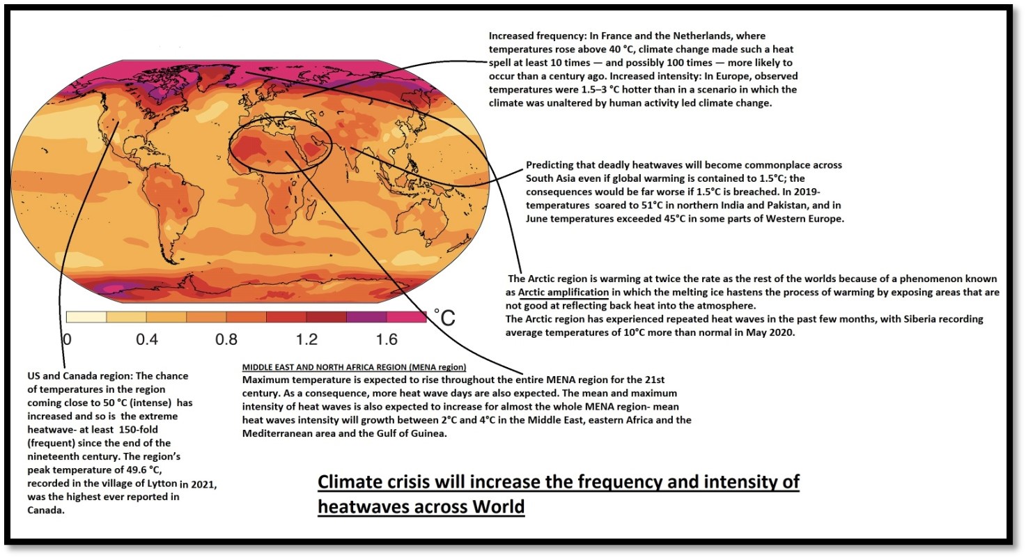
- Global Warming: Nitrous Oxide (N2O) emissions due to excessive use of nitrogen fertilizers in agriculture is leading to rapid warming of earth’s atmosphere as N2O is 300 times more potent GHGthan CO2.India’s agricultural N2O emissions have been increased by around 265% from 1970 to 2018.
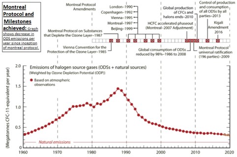
- Ozone depletion: Nitrous oxide has now become the largest ozone depleting substance emitted through human activities especially agriculture.
- Soil Pollution: Excessive use of fertilizers cause soil acidification and degradation of soil health which effects natural soil decomposition. g.Soils of Punjab, Haryana and west UP are facing severe nitrogen pollution due to excessive use of fertilizers.
- Threatens food security: Soil pollution due to excessive fertilizer usage leads to nutrient disorders and increased toxicity in plants. Also, harmful algal blooms leads to toxicity in aquatic organisms which ultimately threatens our food security.
- Health Impacts: Agricultural ammonia emissions can combine with pollution from vehicle exhausts to create dangerous particulates in the air and exacerbate respiratory diseases, including COVID-19. And, the blooms turn lethal for human beings when they consume marine organisms that feed on harmful algae. E.g. Incidents of paralytic shell fish poisoning following an algal bloom was reported in 1981 from Tamil Nadu, Karnataka and Maharashtra which led to several deaths.
- Effect on livelihoods: Soil pollution leads to decrease of crop yields and productivity which affects the livelihood and income and And, aquatic pollution puts the livelihoods of fishing communities at stake.
Way Forward:
- Several SDGs are linked with the efficient use of fertilizers in agriculture.

- Deployment of sustainable agricultural practices: such as inter-cropping of Nitrogen-fixing legumes, planting of cover crops that hold nutrients in soil after harvests, tightening up storage of manure and introducing agro-forestry buffer zones.
- Implementation of Regenerative agricultural practices: which involves restoring of degraded soils using practices based on ecological principles such as minimum tillage, bio composting and integrated livestock farming systems.
- Use of precision agricultural practices: that uses Information Technology (IT) to ensure optimum and efficient use of fertilizers in agriculture.
- Recently, Indian Farmers Fertilizers Cooperative Limited (IFFCO), developed a Nano-technology based Nano Urea (liquid) fertilizer which can improve the Nitrogen Use Efficiency (NUE)& help in reducing the N20 and ammonia emissions into atmosphere.
- Soil Heath Card (SHC) scheme: launched in 2015 under National Mission on Sustainable Agriculture, aims to regulate and minimize the use of fertilizers in agriculture.
Where it can be used?
This can be used in topics related to Paper 1 (Soil degradation, Environmental degradation, Climate Change, Food security, Sustainable development), Paper2 (Fertilizers, Aqua-culture, Sustainable agriculture) and GS3 (Environmental degradation).
Need for coastal zone management in India
Why in News? Kovalam beach in Kerala and Eden beachof Puducherry in India have been awarded “Blue Flag” certification recently, an international eco-level tag, taking the total number of such beaches in the country to 10.
- Coastal zone management (CZM) is a process of managing the coast, in all aspects including geographical and political boundaries, to achieve sustainability. It is critical for utilizing these resources efficiently leading to inclusive growth.
- It is estimated that approximately 4800 billion tons of household waste and 65 million tons of solid waste is dumped annually in the sea. Due to these ongoing attacks on the mangroves, and coral reefs, fish breeding is constantly decreasingand affecting the livelihood of 200 million people living along our country’s 7517 kilometer long coastline.(Map 1)
- The Indian Ocean includes large amounts of minerals including products including cobalt, copper, manganese and rare earth.
- Seawater also contains commercially useful salts including gypsum and common salt.

Map 1: Need for Coastal Management in India
How to Manage?
- Management of the coastal zone depends on the knowledge available on aspects of coastal ecosystems, coastal processes, natural hazards and their impacts, quality of water and living resources awareness and adequate response from the government agencies concerned is the key. (Fig 3)
- In general, the relationship between wetland safety and fish stocks is linear. Wetlands, i.e. the wave attenuation service which protects coasts from storms and tsunamis, provide the ecological services. The relationship between this service area and the wetlands is non-linear. These partnerships have management implications and should be taken into consideration. Impacts of these processes need to be modeled and adaptation and mitigation strategies must be devised for the coastal zone’s sustainable development. Geospatial information technology may make a significant contribution to the creation of these models.


Fig 3: Model for Integrated coastal management
Where it can be used:
- Geography Optional
- P1: Climatology(Climate change) , Environmental Geo (Management and Hazards), Regional Planning and development (coastal area development).
- P2: Regional Development and planning (Drought prone area planning), Contemporary (Tsunamis etc).
- GS: GS3( Environmental management, disaster managemen.)
Polynya
Why in news? - More heat and moisture is released through a large hole in sea ice called polynya, which fuels formation of more clouds, trapping heat in the atmosphere, says new NASA study.
Polynyas are large, persistent regions of open water and thin ice that occur within much thicker pack ice, at locations where climatologically, thick pack ice would be expected.
Polynyas tend to be roughly oval or circular in shape, but they can be irregularly shaped too. Polynyas are generally believed to be of two types (fig 1):

Coastal Polynyas characteristically lies just beyond landfast ice i.e., ice that is anchored to the coast and stays in place throughout the winter. They are thought to be caused chiefly by persistent local off-shore winds, such as foehn or katabatic, winds typically found off the coasts of Greenland and Antarctica, for example, North Water Polynya.
Open Ocean Polynya, the larger and longer-lasting of the two types, form within the ice cover and are behind to be caused by the upwelling of deep warmer water. For example- Weddel Polynya in the Antarctic Weddel Sea.


Fig. Geographic distribution of polynyas. (A) The Arctic, where SLIP is the St. Lawrence Island Polynya, NEW is the North-east Water, and K is the Kashevarov Bank polynya. (B) The Antarctic, where W is the Weddell polynya, M is the Maud Rise polynya and C is the Cosmonaut Sea polynya. On both figures the dashed line indicates the position of the maximum ice edge.
Kelp Forests
- Why in news: Imaginary satellites show that that the area covered by kelp forests off the coast of Northern California has dropped by more than 95 percent and are replaced by “urchin barrens”.

- Background:
- Kelps are large brown algae that live in cool, relatively shallow waters close to the shore. Under ideal physical conditions, kelp can grow 18 inches (45 cm) in a single day.
- Kelp forests are extensive underwater habitats that range along 25% of the world’s coastlines.
- Kelp recruits most successfully in regions of and regions with continuously cold, high-nutrient waters.
- Conditions for growth:
- They grow along rocky coastlines in depths of about 2 m to more than 30 m- relies on sunlight to generate food and energy, therefore kelp always require shallow, relatively clear water.
- Favours nutrient-rich, cool waters that range in temperature from 5° to 20°
- Significance of kelp and their forest:
- Giant kelp forests are among Earth’s most productive habitats and harbour a greater variety and higher diversity of plants and animals. These organisms use the thick blades as a safe shelter from predators or rough storms. Example: Many fish species use kelp forests as nurseries for their young, while seabirds and marine mammals like sea lions, sea otters and even gray whales use them as shelter.
- Act as shelter belt against cyclonic storms.
- Kelp is used as a binding agent in products like ice cream, cereal, ranch dressing, yogurt, toothpaste, lotion and more.
- Threats – faced by kelp ecosystems:
- Sea urchins can destroy entire kelp forests at a rate of 30 feet (9 m) per month- Sea urchins, spiny-globular animals, often completely remove kelp plants by eating through their holdfasts.
- Destructive fishing practices, coastal pollution, and accidental damage caused by boat entanglement are known to negatively affect kelp forests.
- Climate change: regional warming has devastating effect as it alters favourable conditions in which kelp forests thrive.
- Storms and large weather events, like El Niño, can tear and dislodge the kelp.

Primate city
- The concept of the primate citywas first proposed by the geographer Mark Jefferson in 1939.
- He defines a primate city as being “at least twice as large as the next largest city and more than twice as significant.
- Besides from size and economic influence, a primate city will usually have precedence in all other aspects of its country’s society, such as being a center of politics, media, culture and education and receive most internal migration.
How and where primate city concept developed?
It is the result of sucking of resources from periphery to core region. As a result, there is a progressive core & un-progressive periphery. Many factors are responsible for the primate city development, some important factors are: Advantages - Primate City dominates the country's influence due to large size; its strong pull factors lead to the city becoming even larger as compared to other cities. Having a large population means a huge brain, ideas, and flow of information. Agglomeration of economic activities. Large markets of goods and services attract FDI, capital, and the brain from the surrounding region. Disadvantages- Brain drain, migration, huge sucking of capital from the surrounding region leads to unequal economic, political, and resource development. Overpopulation leads to resource depletion and unsustainable urban growth. It is prone to epidemic spread like the coronavirus.


World’s 1st five country transboundary biosphere reserve
Why in news: Recently, UNESCO has designated Mura-Drava-Danube (MDD) as the world’s first five-country Trans boundary biosphere reserve.

Several challenges faced by the region:
- Conflicting land use practices: As borders between states are political rather than ecological, ecosystems often occur across national boundaries, they are subjected to different, or even conflicting management and land use practices.
- River Degradation: A century of river canalization, the building of flood dykes, extraction of gravel and sand and the construction of hydropower projects have led to a loss of up to 80% of the former flood plain areas and the alteration of about 1,100 Kms of natural river banks and stretches.
- Loss of Biodiversity: Long-term river degradation and changes in ecosystem functions has led to severe loss of biodiversity in the region especially the population of river birds. E.g. nearly 80% of sand martin population along the Drava River has been lost in the last 10 years.
How creation of a Transboundary Biosphere Reserve (TBR) will benefit the environment and people in the region?
- Tool for common management: As TBR has international recognition at UN level, it provides a political will to co-operate in the conservation and sustainable use, through common land use practices and management, of a shared ecosystem.
- Flood plain restoration: By removing of river bank reinforcements and reconnection of side-channels and culminating with large-scale reconnection of flood plain areas with rivers.
- Conservation of biodiversity: Significant reduction of river degradation and construction of ecological corridors will safeguard the long term survival of the habitats and species.
- Nature-friendly and sustainable development: through implementation of nature-based solutions involving local communities by inspiring feelings of both provincial and regional pride.
Establishing of such Transboundary Biosphere Reserves (TBR) can help in effective management of biodiversity in regions like Manas BR (spread across India & Bhutan) and Kanchenjunga BR (spread across India &Nepal).
Where it can be used?
It can be used in topics related to Paper 1 (Environmental Degradation, Biodiversity, Sustainable development), Paper 2 (Floods, Wildlife conservation, Tribal area development) and GS3 (Environmental degradation).
DeeporBeel Wildlife Sanctuary
|
DeeporBeel Wildlife Sanctuary
|
|
Corbett Tiger Reserve
|
|
Nagapattinam
|
|
Rushikulya River
|
|
Kalingapatnam
|
|
Zojila Pass
|

Share the article
Get Latest Updates on Offers, Event dates, and free Mentorship sessions.

Get in touch with our Expert Academic Counsellors 👋
FAQs
Geography Current Affairs focuses on the contemporary issues, events, and developments in the field of geography. It covers recent geographical phenomena, environmental changes, geopolitical shifts, and related news. This differs from regular geography studies which may focus more on foundational concepts, historical contexts, and theoretical frameworks.
Updates are provided regularly to ensure that subscribers stay informed about the latest developments in geography. Typically, updates are provided on a fortnightly basis, depending on the frequency of significant events and changes in the field.
Absolutely. Geography Current Affairs serves as a valuable resource not only for Geography optional but also for GS papers, especially GS Paper 1 (covering Indian Heritage and Culture, History, and Geography of the World and Society) and GS Paper 3 (covering Technology, Economic Development, Biodiversity, Environment, Security, and Disaster Management). It aids in building a holistic understanding of various topics and strengthens answer-writing skills by incorporating contemporary examples and perspectives.
Geography Current Affairs holds immense importance for UPSC preparation, particularly for aspirants opting for Geography optional. It helps candidates stay updated with the latest developments, geographical phenomena, environmental issues, and geopolitical shifts worldwide, aligning them with the dynamic nature of the subject as tested in the UPSC examinations.