10 Aug to 24 Aug, 2024
KOSI - MECHI RIVER LINKING PROJECT
Why in news : The Kosi-Mechi River Linking Project, part of India’s ambitious National Perspective Plan (NPP) for interlinking rivers, has become a point of contention. Flood victims in Bihar have protested against its implementation.
About :
National Perspective Plan : The National Perspective Plan (NPP) was prepared by the then Ministry of Irrigation (now Ministry of Jal Shakti) in August 1980 for water resources development through inter basin transfer of water, for transferring water from water surplus basins to water-deficit basins. Under the NPP, the National Water Development Agency (NWDA) has identified 30 links (16 under Peninsular Component & 14 under Himalayan Component) for preparation of Feasibility Reports.
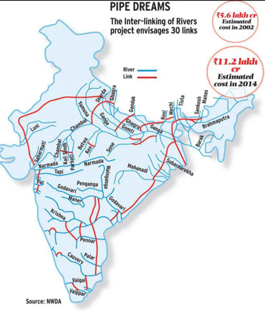
Significance of NLP
- Redistribution of Water for Flood and Drought Control: States like Bihar and Assam frequently face devastating floods due to the overflow of rivers like the Kosi and Brahmaputra. By redistributing excess water to the drought-prone regions of western and peninsular India, such as Rajasthan, Gujarat, Andhra Pradesh, Karnataka, and Tamil Nadu, the project aims to alleviate water scarcity.
- Enhanced Irrigation and Agricultural Productivity: Availability of consistent water supply could revolutionize farming in Rajasthan’s Thar Desert and the drought-prone districts of Tamil Nadu, increasing agricultural productivity. This enhancement in irrigation facilities is expected to contribute to food security and support the government's goal of doubling farmers' income
- Hydropower Generation: In states like Himachal Pradesh and Uttarakhand, hydropower has already proven to be a game-changer for rural electrification and industrial growth. The energy generated can help bridge the power deficit in several states, fostering economic development and improving living standards.
- Commercial and Logistical Benefits: The National Waterway-1 on the Ganga river, which already supports cargo movement, could be connected to other parts of the country, enhancing the logistics infrastructure. The project could also bolster the ‘Make in India’ initiative by providing cost-effective transportation for industrial products.
- Contribution to Sustainable Development: The Central Ground Water Board (CGWB) has reported alarming declines in groundwater levels across states like Punjab, Haryana, and Uttar Pradesh. By utilizing river water for agriculture and drinking purposes, the project could recharge aquifers and prevent the flow of freshwater into the sea, thereby promoting sustainable water management practices.
- Socio-economic and Gender-related Benefits: The interlinking project will reduce the burden on women who currently have to walk long distances to fetch water, particularly in rural areas. Additionally, the project is expected to create employment opportunities in rural areas through construction activities, maintenance of canals, and related industries. These jobs can provide stable income sources and contribute to poverty alleviation. Moreover, the multiplier effects through backward and forward linkages—such as the growth of agro-based industries and enhanced market connectivity—can further stimulate regional economies.
Challenges with Interlinking of Rivers
- Environmental Challenges: Narmada Canal has experienced substantial water loss due to evaporation in the arid regions it passes through. In addition, large-scale irrigation projects in regions like Punjab have led to waterlogging and salinity, rendering vast tracts of land unproductive.
- Developmental Displacement: Construction of the Sardar Sarovar Dam on the Narmada River displaced more than 200,000 people, leading to prolonged legal and social conflicts.
- Lack of Transparency and Information: Kosi-Mechi River Interlinking Project has faced criticism for not conducting thorough environmental impact assessments (EIAs) or public consultations.
- Impact of Climate Change: The Intergovernmental Panel on Climate Change (IPCC) has projected increased frequency of extreme weather events, including droughts and floods, which could disrupt the water availability in interlinked rivers. Changing monsoon patterns in India have already affected water storage in reservoirs like those on the Krishna and Godavari rivers, complicating the management of water resources.
- Federal Aspects: Water is a state subject under the Indian Constitution, making it challenging to resolve issues of water sharing between states. The longstanding dispute between Kerala and Tamil Nadu over the Mullaperiyar Dam is a prime example.
- Challenges in Coordination with Neighboring Countries: Coordinating river interlinking projects with neighboring countries like Bhutan, Nepal, and Bangladesh presents significant diplomatic challenges. Ganga Water Treaty between India and Bangladesh has faced periodic tensions
- Unexplored Alternatives: Alternatives like watershed development, rainwater harvesting, and optimizing existing infrastructure could effectively address India's water woes without the environmental and social costs of river interlinking.
Key Facts About the Kosi-Mechi River Linking Project
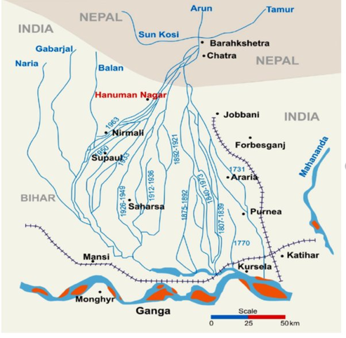
- The project involves linking the Kosi River with the Mechi River, a tributary of the Mahananda River, impacting regions in Bihar and Nepal.
- The project is aimed to provide annual irrigation to 4.74 lakh hectares (2.99 lakh hectares in Bihar) and 24 million cubic meters (MCM) of domestic and industrial water supply.
Concerns
- Despite government claims, the project does not have a significant flood control component, which is a major concern for the flood-prone region.
- Flooding and land erosion have destroyed homes and inundated crops, affecting local livelihoods and villagers living between embankments.
- The project's focus on irrigation does not address these immediate and recurring challenges.
Solutions For Interlinking of RIvers
- Virtual Water Trade (VWT): Virtual Water Trade involves the exchange of water-intensive goods (like agricultural products) between regions with abundant water resources and those experiencing water scarcity. This concept can help alleviate water stress by reducing the need for water-intensive crops in arid areas. For example, Egypt imports wheat, which is water-intensive to grow, from countries with more water resources, thereby conserving its own limited water supply.
- Government Road Map: Road map should be based on rigorous Environmental Impact Assessment (EIA) studies. World Bank-supported Maharashtra Water Sector Improvement Project included detailed EIAs to assess and mitigate the environmental impacts of water infrastructure projects.
- Sustainable Future: The revival of traditional water harvesting structures, such as Johads in Rajasthan, has successfully recharged groundwater levels, transforming barren lands into fertile agricultural areas. The Jal Shakti Abhiyan, a campaign by the Indian government, emphasizes protecting recharge zones to enhance groundwater resources, which can be integrated into the river interlinking strategy.
- Comprehensive Water Law: The National Water Policy (2012) provides a framework, but it needs to be expanded and enforced to cover the challenges posed by large-scale projects like river interlinking. Australia’s National Water Initiative serves as a model for integrating water law, policy, and management across states, ensuring sustainable water use.
Where to use :
Paper II ( Geography Optional ) : River Interlinking and Contemporary issues
Paper I ( General Studies ) : Resources
CLIMATE CHANGE AND EARTH’S ROTATIONAL DYNAMICS
Why in news : Recent research highlights that melting polar ice caps due to climate change are causing the Earth to spin more slowly, leading to minute changes in the duration of a day.
About:
How is Climate Change Affecting Earth's Rotation?
- Melting Ice Caps and Earth's Rotation: The melting of polar ice sheets shifts water towards the equator, increasing the Earth's oblateness and moment of inertia. This redistribution of mass causes a slowdown in Earth's rotation, which has decelerated by about 1.3 milliseconds per century over the past two decades.
- This effect is explained by the principle of angular momentum, where an increase in moment of inertia near the equator leads to a decrease in rotational speed.
- Projections indicate that with continued high emissions, this rate may double to 2.6 milliseconds per century, making climate change a key factor in Earth's rotational slowdown.
- Axis Shifts and Chandler Wobble: Melting ice also causes a slight shift in Earth's axis of rotation, highlighting the broader impact of climate change on fundamental Earth processes. This axis shift contributes to the Chandler wobble, a natural oscillation in Earth's rotational axis, which can affect rotational stability and timing.
Factors Affecting the Earth's Rotation Speed
- Groundwater Depletion: Loss of groundwater alters Earth's mass distribution, affecting rotational dynamics.
- Torsional Waves: Convection currents in the Earth's outer core generate torsional waves, which twist around the Earth's axis, impacting rotational speed and correlating with changes in the length of a day.
- Influence of Celestial Bodies: Earth's rotation is affected by the Moon and other celestial bodies. About 1.4 billion years ago, the Moon's closer proximity resulted in shorter days (18 hours and 41 minutes). The gradual distancing of the Moon continues to slow Earth's rotation, contributing to the current 24-hour day.
- Earth's Interior Dynamics: Movements within the Earth's mantle and core, such as inner core tilt and core density fluctuations, influence rotational speed.
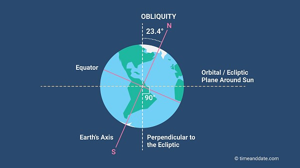
Impact of Slowdown of Earth's Rotation
- Leap Seconds: Earth's rotation affects the need for leap seconds to align atomic clocks with solar time. Slower rotation may require additional leap seconds, potentially causing issues in technology like network outages and timestamp discrepancies.
- GPS Accuracy: GPS systems, reliant on precise timing, can experience minor navigation errors due to variations in Earth's rotation.
- Sea Level Rise and Ocean Currents: Melting polar ice redistributes mass, altering sea levels and ocean currents like the Global Mean Ocean Circulation (GMOC). Slower rotation can influence these currents, affecting regional climates and worsening sea level rise.
- Tectonic Activity: Changes in Earth's rotation and mass distribution may impact tectonic stress, potentially influencing earthquakes and volcanic activity.
- Climate Change Impact: These rotational changes underscore the profound effects of climate change, extending beyond weather and sea levels to the Earth's rotational mechanics.
https://www.jpl.nasa.gov/news/nasa-funded-studies-explain-how-climate-is-changing-earths-rotation
Where to use :
Paper I ( General Studies ) : Climate change impact on earth surface
NEW LANDSLIDE HOTSPOTS FOUND IN HIMALAYAS , WESTERN GHATS
Why in news : Frequency of landslides is increasing in vulnerable areas due to infrastructural development and deforestation.
About :
Types of Landslide
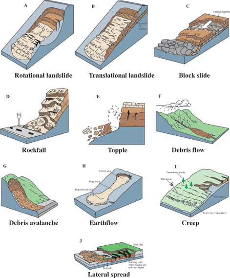
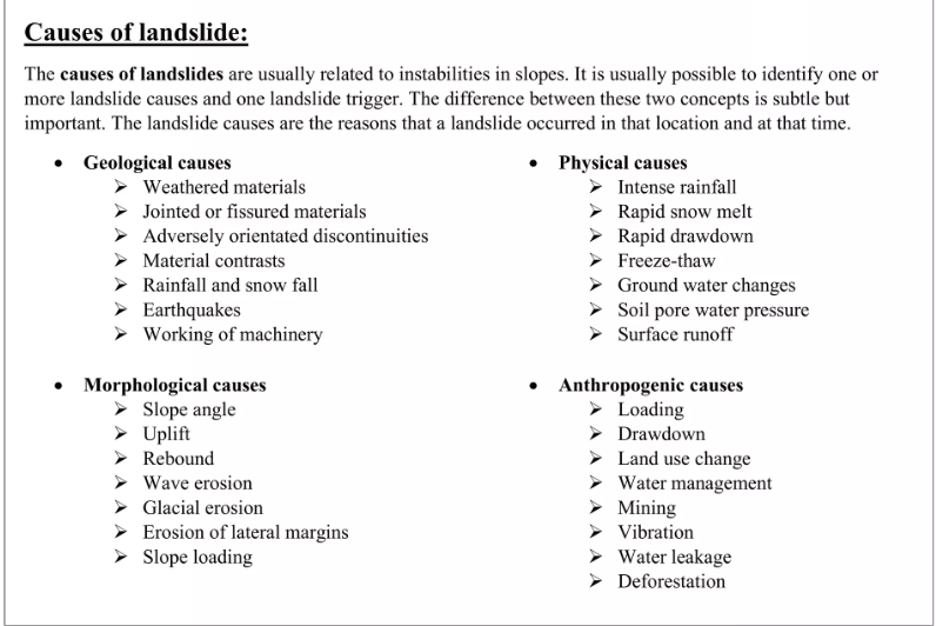
Impact of Landlsides
- Loss of Life and Property: Landslides often result in tragic loss of life and destruction of property. 2024 landslides in Wayanad, Kerala, claimed the lives of around 300 people and displaced thousands, leaving entire villages devastated.
- Infrastructure Damage: The 2020 landslides in Uttarakhand's Chamoli district destroyed key roads and bridges, cutting off remote villages from the rest of the region and hampering rescue and relief efforts.
- Economic Losses: In Darjeeling, West Bengal, recurrent landslides have severely impacted the region's tea industry, a major economic driver.
- Environmental Degradation: The 2018 landslides in Kodagu, Karnataka, caused severe soil erosion, leading to loss of fertile topsoil and significant deforestation. This, in turn, polluted rivers and streams with sediments, affecting aquatic ecosystems and water quality downstream.
- Disaster Relief and Rehabilitation: The 2017 landslide in Mandi, Himachal Pradesh, required extensive relief operations, including the deployment of the National Disaster Response Force (NDRF). The financial burden of these operations diverted funds from planned developmental projects, delaying their implementation.
- Psychological Impact: The 2014 Malin landslide in Maharashtra, which buried an entire village, left survivors with lasting emotional scars. Many reported symptoms of PTSD, anxiety, and depression, necessitating long-term mental health support for the affected population.
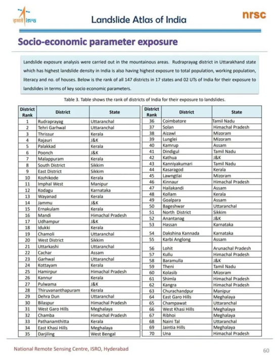
Comparison between landslides in the Western Ghats and the Himalayas
|
Factor |
Western Ghat |
Himalayas |
|
Topography |
Lower altitude, less steep slopes |
Higher altitude, steeper slopes |
|
Geological formations |
Older, more stable rock formations (generally) |
Younger, weaker rock formations |
|
Rainfall |
High Rainfall: Heavy monsoon rains contribute to frequent landslides. |
Variable Rainfall: Heavy monsoon rains in foothills and significant snowfall in higher elevations. |
|
Landslide Frequency |
High Frequency: Frequent landslides during monsoon season; numerous events annually. |
Very High Frequency: Frequent landslides year-round due to intense rainfall and seismic activity. |
|
Landslide Triggers |
Monsoon Rains, Deforestation, Construction: Heavy rains, human activities like deforestation and construction. |
Rainfall, Snowmelt, and Earthquakes: Intense rainfall, snowmelt, and seismic activity are major triggers. |
|
Mitigation Measures |
Afforestation, Drainage Systems, Land Use Planning: Focus on vegetation and engineering solutions. |
Slope Stabilization, Early Warning Systems, Engineering Solutions: Emphasis on monitoring and robust engineering practices. |
Way Forward
- Strengthened Disaster Management and Early Warning Systems like Kerala.
- Comprehensive Land Use Planning and Zoning as in Karnataka .
- Investment in Research and Technology:
- Community-Based Disaster Risk Reduction as done by The Nilgiri District Administration
- Sustainable Development and Ecosystem Restoration:
- Infrastructure Development with Resilience
https://indianexpress.com/article/india/wayanad-kerala-why-landslides-occur-9488271/
Where to use
Paper III ( General Studies ) : Disaster Management
Paper II ( General Studies ) : Landslides and Disaster
Optically stimulated luminescence (OSL) dating
Optically stimulated luminescence (OSL) dating: Optically Stimulated Luminescence (OSL) dating is a method used to determine the last time mineral grains, typically quartz or feldspar, were exposed to light. When these minerals are buried, they accumulate a luminescence signal due to exposure to natural radiation. OSL dating measures this trapped energy released as light when the minerals are stimulated by light in the laboratory.
Carbon capture & Storage
Carbon capture & Storage : Carbon Capture, Utilization, and Storage (CCUS) encompasses methods and technologies to remove CO2 from the flue gas and from the atmosphere, followed by recycling the CO2 for utilization and determining safe and permanent storage options. CO2 captured using CCUS technologies is converted into fuel (methane and methanol), refrigerants and building materials.
Biomass Co firing
Biomass Co firing : Biomass co-firing is a promising technology to decrease the use of fossil fuels for energy generation and hence mitigate greenhouse gas emissions. It stands for adding biomass as a partial substitute fuel in high efficiency coal boilers.
Cavern based storage
Cavern based storage : Cavern-based storage facilities are storage facilities for crude oil or petroleum products that utilize naturally occurring underground caverns for storage purposes. These caverns are typically formed in salt formations or other geological formations through processes such as solution mining or excavation.
Tail Water streams
Tail Water streams : Tail water streams are found below dams and their water source flows from the reservoir. The outlet comes from controlled head gates which release water out from the bottom of the dam.As a result, the most dense and coldest water is released.
IMPACT OF BRICK KILN EMISSIONS ON SOIL QUALITY
- There are more than 7000 active brick kilns in Bangladesh to meet the country's growing demand for building materials. Urban air pollution has become a great concern in this region due to the stack emissions during the brick manufacturing period.
- However, study has also assessed the effect of heavy metals released from brick kiln emissions during their production period on the adjacent soil environment of the region.
- The concentration level of cadmium resulted to be very high than its threshold limit in the majority of the sampling locations. Study findings indicate prospective damage to the studied soil environment and ecological settings of Ashulia, due to the emissions from the brick kilns which require suggested emission control and soil remediation actions, and implementation of eco-brick manufacturing technologies without further delay.
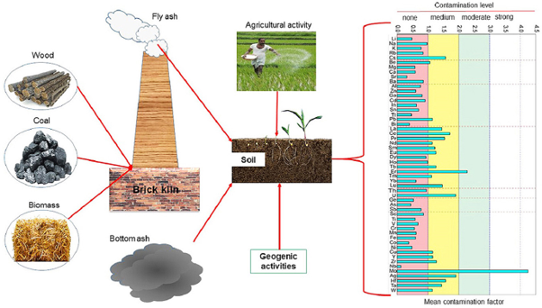
Where to use ?
Paper I ( Geography optional ) : Soil erosion and degradation , Influence of man on ecology
Source :
https://www.sciencedirect.com/science/article/pii/S2667010022001962
Places in News - 24 August 2024
1. Khandwa
Why in news : Recently, SJVN Green Energy Limited (SGEL) commissioned a 90 MW Omkareshwar Floating Solar Project in Khandwa.
- It is formerly known as the East Nimar district in Madhya Pradesh
- It includes the lower valley of the Narmada River, Kherkhali River, Choti Tawa River, Shiva River.
- Burhanpur District was separated from Khandwa District on 15 August 2003.
- Khandwa District is part of Indore Division.
- Approx : Indore
2. Kunthi River
Why in news : The scientific name of the Neelakurinji is named after the Kunthi River in Kerala's Silent Valley National Park where it is abundantly found.
- The Kunthipuzha River is a waterway located in the state of Kerala, India.
- It flows through the Silent Valley National Park.
- This river is also called the 3Thuthapuzha by the local population.
- Kunthipuzha is one of the main tributaries of the Bharathapuzha River
- Approx : Palakkad district
3. Sakleshpur
Why in news : Landslides in key coffee-growing areas like Sakleshpur and Wayanad resulted in significant plant and plantation losses.
- Situated on the foothills of the Western Ghats, Sakleshpur is a picturesque town near Bengaluru in Karnataka
- The region has a number of stunning waterfalls, such as Murkannu Gudda And Hadlu Waterfall, Magajahalli Waterfalls, and Magajahalli Waterfalls.
- Approx . Bengaluru
4. Sulur
Why in news : Phase one of the exercise was concluded at Sulur in Tamil Nadu from the 6th-14th August and four countries including France, Germany, Spain and the United Kingdom participated with their assets.
- Sulur is a town located in the Coimbatore district of Tamil Nadu, India.
- It is a medieval period trade centre situated in the left bank of the river Noyyal.
- It is a popular location for various textile mills and weaving slots.
- Approx : Coimbatore
5. Nanjarayan Bird Sanctuary
Why in news : Recently, the centre declared the Nanjarayan Bird Sanctuary and Kazhuveli Bird Sanctuary in Tamil Nadu and Tawa Reservoir in Madhya Pradesh as three new wetlands as Ramsar Sites.
- It is a protected area and bird sanctuary located in Tiruppur district of the Indian state of Tamil Nadu.
- The sanctuary covers an area of 1.26 km2 and was notified in 2022.
- It was designated as a Ramsar site of International importance in 2024.
- The lake derived it's name from King Nanjarayan who repaired and restored the lake during his reign
- Approx : Tirrupur
Fortnightly KOSMOS MCQs Practice
Q1. Consider the following statements regarding Hoolock Gibbon:
- These are the smallest and fastest apes found in Asia's tropical and subtropical forests.
- They have distinct white eyebrows, long arms, and a vocal sac for calls.
- In India, they are protected under Schedule 1 of the Wildlife Protection Act, 1972.
Which of the statements given above is/are correct?
- 1 and 2 only
- 2 and 3 only
- 1 and 3 only
- 1, 2, and 3
Q2. Consider the following statements regarding the Pangong Tso Lake:
- It is a long, narrow, and deep endorheic lake situated at over 14,000 feet in Ladakh.
- Approximately one-third of the lake lies in China, while two-thirds are in India.
- It is a tectonic lake, formed when India separated from Gondwanaland and collided with Asia.
How many of the statements given above is/are correct?
- Only one correct
- Only two correct
- All three correct
- None
Q3. Consider the following statements about Cloudbursts:
- It happens when strong upward currents of hot air stop raindrops from falling, allowing them to grow larger while new, smaller drops form below.
- This phenomenon is common in hilly regions, where the complex topography aids in orographic lifting.
Which of the above statements is/are not correct?
- Only 1
- Only 2
- Both 1 and 2
- Neither 1 nor 2
Q4. Consider the following statements related to Pulses Production in India,
- India is the world's largest producer and importer of pulses.
- Kharif pulses account for over 60% of the country's total production.
- The leading pulses-producing states are Madhya Pradesh, Maharashtra, and Rajasthan.
How many of the above statements is/are correct?
- Only one
- Only two
- All three
- None
Q5. Consider the following statements regarding India State of Forest Report (ISFR) 2021:
- Arunachal Pradesh has seen the highest increase in forest cover.
- Madhya Pradesh has the largest forest cover in India.
- Mizoram has the highest percentage of forest cover w.r.t. total geographical area of the state.
Which of the above statements is/are correct?
- 1 and 2 only
- 2 and 3 only
- 1 only
- 2 only
Q6. Consider the following pairs:
Mangroves. : State
- Dhamra mangroves : West Bengal
- Coringa mangroves : Andhra Pradesh
- Coondapur mangroves : Karnataka
- Vaitarna mangroves : Maharashtra
Which of the above mentioned pairs are correct ?
- One pair
- Two pairs
- Three pairs
- Four pairs
Q7. Consider the following pairs :
Tiger reserve : State / Places
- Pench Tiger reserve : Maharashtra
- Amrabad Tiger reserve : Andhra Pradesh
- Palamau : Chhattisgarh
- Dandeli- Anshi. : Karnataka
Which of the above mentioned pairs are correctly matched ?
- One pair
- Two pairs
- Three pairs
- Four pairs
Q8. Consider the following statements about Bhakra Dam.
- It is located on the Beas river near Punjab-Himachal Pradesh border.
- It is the 2nd largest reservoir in India by storage capacity.
- It is renowned as a ‘New Temple of Resurgent India’ by Jawaharlal Nehru.
Which of the following statements is/are correct?
- 1 and 2 only
- 2 and 3 only
- 1 and 3 only
- 1, 2 and 3
Q9. Which among the following are not included in process of carbon capture and storage ?
- Co2 is isolated from other gases generated during industrial processes or power generation.
- Co2 is compressed and transported to designated sites frequently through pipelines.
- Co2 injected into subterranean rocks , when it remains stored for extended periods.
- None of the above
Consider the following :
- Vishakhpatnam
- Padur
- Digboi
- Chandikole
Q10. Which of the above mentioned places have Strategic petroleum reserves in India ?
- Only one
- Only Two
- Only three
- All four
Share the article
Edukemy’s Current Affairs Quiz is published with multiple choice questions for UPSC exams
MCQ
Get Latest Updates on Offers, Event dates, and free Mentorship sessions.

Get in touch with our Expert Academic Counsellors 👋
FAQs
Geography Current Affairs focuses on the contemporary issues, events, and developments in the field of geography. It covers recent geographical phenomena, environmental changes, geopolitical shifts, and related news. This differs from regular geography studies which may focus more on foundational concepts, historical contexts, and theoretical frameworks.
Updates are provided regularly to ensure that subscribers stay informed about the latest developments in geography. Typically, updates are provided on a fortnightly basis, depending on the frequency of significant events and changes in the field.
Absolutely. Geography Current Affairs serves as a valuable resource not only for Geography optional but also for GS papers, especially GS Paper 1 (covering Indian Heritage and Culture, History, and Geography of the World and Society) and GS Paper 3 (covering Technology, Economic Development, Biodiversity, Environment, Security, and Disaster Management). It aids in building a holistic understanding of various topics and strengthens answer-writing skills by incorporating contemporary examples and perspectives.
Geography Current Affairs holds immense importance for UPSC preparation, particularly for aspirants opting for Geography optional. It helps candidates stay updated with the latest developments, geographical phenomena, environmental issues, and geopolitical shifts worldwide, aligning them with the dynamic nature of the subject as tested in the UPSC examinations.

