01 Jan
Menace of water pollution in India-Consequences & Road ahead
In News
India is facing a huge menace of water pollution as reported regularly.
Introduction
Water pollution is the contamination of natural water bodies by direct or indirect addition of pollutants into the water bodies without proper treatment. With growing and urbanizing India, its water bodies are getting toxic too. Around 70% of surface water in India is estimated to be unfit for consumption.
Extent of Water Pollution in India
Both the groundwater and surface water in the country are heavily polluted.
- River Water Pollution
- According to an assessment by the CPCB in 2018, there were 351 polluted river stretches (302 in 2015) in the country, with 45 of them being critically polluted.
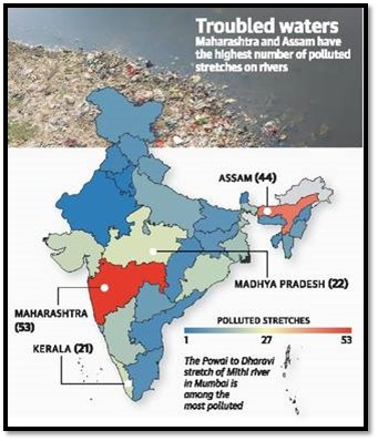
- Nearly one-third of the polluted river stretches are in Maharashtra, Assam and Gujarat.
- The assessment has highlighted four significant stretches of pollution which includes the Mithi river—Powai to Dharavi; the Godavari—Someshwar to Rahed; the Sabarmati—Kheroj to Vautha; and the Hindon—Saharanpur to Ghaziabad.
- Maharashtra has the highest number of polluted river stretches (53), followed by Assam (44), Madhya Pradesh (22), Kerala (21), Gujarat (20), Odisha (19), and West Bengal and Karnataka (17).
- Sources of Pollution: discharge of untreated or partially treated sewage from cities / towns and industrial effluents in their respective catchments, problems in operation and maintenance of sewage / effluent treatment plants, lack of dilution, dumping of solid waste on river banks and other non-point sources of pollution.
- Rapid urbanisation and industrialisation have compounded the problem. According to a CPCB report (2021), sewage generation from urban areas is estimated at 72,368 million litres per day (MLD), but sewage treatment capacity of only 44% was available. This gap between sewage generation and treatment remains a major point source for increasing river pollution.
- Ground Water Pollution
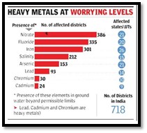
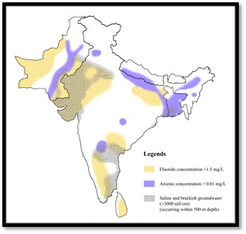
- According to a government reply in Parliament in 2018, Overall, the groundwater is contaminated with the presence of excess nitrate in as many as 386 districts followed by fluoride in 335 districts, iron in 301 districts, salinity in 212, arsenic in 153 districts, lead in 93 districts, chromium in 30 districts and cadmium in 24 districts of different states across India. Many districts have more than one, two or three toxic elements in their groundwater.
- States like Punjab, Haryana, Uttar Pradesh, Tamil Nadu, Telangana and West Bengal reported presence of all types of toxic elements, including heavy metals, in the groundwater of their one or the other district.
- Industrial discharges, landfills, fertilisers and pesticides are possible sources of contamination of groundwater. Experts believe geological sources also cause contamination when GW levels fall steeply to levels where these toxic elements are present. Indiscriminate extraction has already pushed down these levels in many parts of the country.
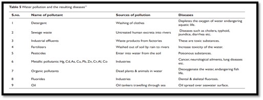
- Marine pollution: It is the pollution of the water of oceans and seas through various sources. Point sources of marine pollution are domestic sewage and industrial effluents. Non-point sources draining to coastal waters include surface run-off from agricultural areas, wash out of agrochemicals, and transport of sediments due to coastal erosion or desertification and deforestation in the hinterland. Oil spill is also prominent pollutant.
Consequences of Poor Water Quality: Various Water Risks
- Social and Political Risks
- Food Security: India hosts over one-sixth of the global population, and serving the food needs of its entire population will be a daunting task. Water shortages due to lack of potable water will make this task harder.
- The declining Groundwater resources, which account for nearly two-third of irrigation water, highlight serious water concern for the agriculture sector. Being downstream of polluted stretches in India is associated with a 9% reduction in agricultural revenues and a 16% drop in downstream agricultural yields.
- Production challenges are being felt across agrarian states as regions run out of their primary irrigation sources. Climate change will only further exacerbate the country’s food security challenges.
- Water Security: As per as the National Sample Survey Office’s (NSSO) 76th round, 21.4% households in India has piped drinking water connections,. The situation is worse in rural India, where just 11.3% households receive potable water directly at homes. In urban India, 40.9% households have piped water connections. The current water pollution poses a significant challenge to government’s Jal Jeevan Mission- Rural and Urban to provide potable tap water 24X7.
- Exceeding the carrying capacity of urban hubs: India’s urban population is expected to reach 600 million by 2030 with water demand expected to double by that time.
- Hampered Gender Mainstreaming: Women are always at the receiving end of water crisis as they have to travel far in search of good quality water.
- Disease burden and Inequality may rise as health impact and other related aspects of poor water quality affects the poor the most.
- Interstate water river dispute may also be worsened due to political compulsions to fulfuill the water needs of the population.
- Food Security: India hosts over one-sixth of the global population, and serving the food needs of its entire population will be a daunting task. Water shortages due to lack of potable water will make this task harder.
- Economic risks: The worsening water quality may lead to a water crisis thus hampering the production capacity utilization and new investments, threatening the livelihoods of millions and rising commodity prices. Such circumstances can lead to economic instability and disrupt growth.

- Environmental risks: As India’s water crisis worsens, environmental damage will intensify with increased attempts towards finding additional water resources. This will lead to serious harm to the country's biodiversity, environment, and ecological balance.

-
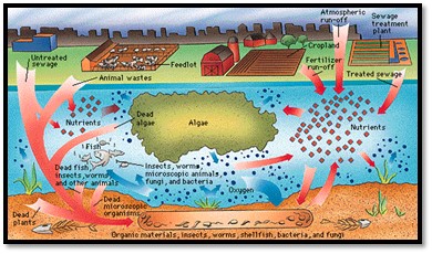
- Risk of biodiversity destruction: Poor water quality creates dead zone and biological deserts in the freshwater ecosystem. This leads to mass mortality and further deterioration of biodiversity and water quality.
- Risk of desertification: Water management and desertification have a two-way relationship. Extensive groundwater extraction due to loss of good quality surface water resources contributes to loss of vegetation cover, which eventually leads to desertification. Increasing desertification and land degradation diminish green cover, which reduces the land’s capacity to recharge groundwater and regional water tables.
Control of Water Pollution: The Way Forward
The key challenges to better management of the water quality in India comprise of temporal and spatial variation of rainfall, uneven geographic distribution of surface water resources, persistent droughts, overuse of ground water and contamination, drainage and salinisation and water quality problems due to treated, partially treated and untreated wastewater from urban settlements, industrial establishments and runoff from irrigation sector besides poor management of municipal solid waste and animal dung in rural areas.
Some of the control measures are given below:
- Decentralised and Participatory approach: Involvement of Panchayats and cities along the river to prepare river cleaning plans and continuous monitoring of river water quality with the help of central agencies such as CPCB, SPCBs and Ground Water authorities.
- Watershed and River basin based approach: This entails the planning for entire river system including the tributaries. This will ensure holistic development of river basin in terms of water quality and river ecosystem.
- Both the above approaches are being utilised under the National Mission for Clean Ganga (NMCG) by developing Ganga Grams, Ganga Prahari (A cadre of motivated volunteers from the local community) and Ganga River Basin.

- Urban waterbodies restoration: All the urban waterbodies such as lakes, wetlands, ponds etc. must be revived and restored to naturally clean the groundwater, raise its level and support biodiversity. The revival of Jakkur lake, with integrated wetlands ecosystem in Bangalore, is an example of community effort.
- The lake was revived by treating the wastewater entering the lake in three parts. First, all solid material and chemicals were removed. Second, the sewage treatment plant (STP) removed nutrients and ions from entering the water body. Third, natural algae ponds or ecosystem were created for the lake to undergo a biophysical and chemical process. Such self-sustainable ways, along with the confidence of stakeholder, can help restore the lake by 90 per cent.
Where to use
P1 – Environment Geography, Settlement
P2 – Water resources, Settlement, Contemporary issues
References
Changing monsoon patterns in peninsular India-causes and consequences
Context: Incessant heavy rains and floods over peninsular India during this October and November (even though the two rain-bearing systems are generally inactive during this period)-indicating a drastic change in the monsoon patterns.
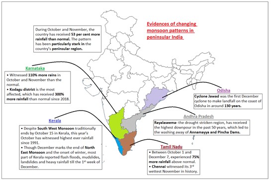
Causes of changing monsoon patterns over peninsular India:
- Changing climate: The entire northern hemisphere, including the oceans, has remained warm from January through October in 2021, with the only exception of the Siberian High. This warming leads to the formation of local low-pressure systems which are attributed to the delayed monsoon withdrawals.
- Madden-Julian Oscillation (MJO): Presently, La Niña conditions are prevailing over the equatorial Pacific Ocean and neutral Indian Ocean Dipole (IOD) conditions over the Indian Ocean. Normally, during La Nina conditions, rainfall is normal or below normal during the northeast monsoon in southern Peninsular India. But this time rainfall is higher because of the favourable location of MJO.
- Arctic sea-ice loss: The Arctic sea-ice loss this year led to high sea-level pressure over western Europe and northeastern China, which steered planetary waves southeastward instead of their eastward trajectory. These
waves, which produce circulation anomaliesin the upper atmosphere, entered India latein the season and delayed the monsoon - La-Niña: During which the sea surface temperatures over the eastern and central Pacific Ocean remain cooler than average, affects the trade winds which carry this weather disturbance across the world. In India, La-Niña generally triggers the formation of low-pressure areas, which contribute to increased rainfall. Thus, a moisture-laden
atmosphere combined with La Niña conditions is likely to have created conducive conditions for the formation of more low pressure areas, and rainfall events.
|
An analysis of IMD data shows between October 1 and December 1, the Indian Ocean saw the formation eight low-pressure areas; five of them intensified to become depressions. On an average, India records three depressions during the two months. Such high number of depressions during the months of October and November have been recorded only in 10 years since 1901. |
- Warming Arabian Sea: The other reason for the unusual rains is the warming up of the Arabian Sea over the past decade. This causes higher evaporation which increases the chances of the formation of a low-pressure areas. On some occasions, the pairing of these low-pressure systems resulted in the formation of troughs (elongated regions carrying winds and rain) over the Indian landmass and it resulted in widespread rainfall.
Consequences of changing monsoon patterns:

The country’s first ever official climate change report, the Assessment Of Climate Change Over The Indian Region, published by the ministry of earth sciences (MoES) in 2020, lays out the state of the monsoon in a rapidly heating world quite clearly. Since 1951, the monsoon circulation has weakened, especially in regions like the Western Ghats and the Indo-Gangetic plains. Simultaneously, however, incidents of localized heavy rainfall have increased. What has also increased is the duration of dry spells between rainy days during the monsoon.
Where it can be used?
It can be used in topics related to Paper 1 (Climate Change, Indian Ocean, Tropical cyclones) and Paper 2 (Mechanism of Indian monsoons and rainfall patterns, agriculture, floods).
Sources:
Increasing droughts in South-East Asia- Analysis of ASEAN REGIONAL PLAN OF ACTION FOR ADAPTATION TO DROUGHT
In news: Recently, COP26 report highlighted that Southeast Asia needs to boost disaster resilience, as climate change could have severe economic impact.
- Background:
- South-East Asia has long endured severe droughts, which occur on average every five years. The prolonged 2015 and 2018 droughts were the worst on record for two decades. They simultaneously affected more than 70 per cent of the land area, with over 325 million people exposed.
- The drivers of drought risk in South-East Asia are inherently complex- heavily influenced by various climatic drivers, mainly the El Niño-Southern Oscillation (ENSO) and Indian Ocean Dipole (IOD).
- According to report by the ESCAP and ASEAN - statistically significant increase in temperature from 1981-2020 is expected to continue.
- The ASEAN Leaders recognized the urgency of the issue when they commended the adoption of the ASEAN Declaration on the Strengthening of Adaptation to Drought in 2020 with an aims to enhance coordination at the regional and national (international) level for achieving sustainable management of drought.
- Regional drought prevalence in South East Asia:
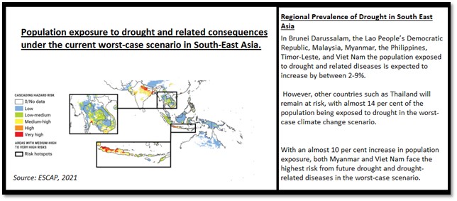
- ASEAN regional plan of action for adaptation to drought:
- Goal and objectives of the Regional Plan of Action for Adaptation to Drought:

-
- Analysis of Regional plan of action for adaptation of drought:
- Positive aspects:
- Institutionalization, localization and multi-sectoral strategic actions against drought: droughts trigger major economic and social disruption, humanitarian disasters and food insecurity. Keeping this in view, ASEAN through this plan will aim to implement multi-sectoral strategic actions on drought adaptation, mitigation, and emergency response at and encourage communication exchange among all stakeholders.
- Gender and social inclusion- Plan considers a whole-of-society approach in disaster management by recognizing the key roles and unique needs of those most affected, including women, children, youths, the elderly, the poor and people with disabilities as well as other vulnerable groups. Thus help address gender dimension of droughts.
- Multi-hazards and pro-active approach- Enhance regional capacities to assess, mitigate, prepare for, and respond to a wider range of national hazards and disaster risks beyond drought in the region. States take the proactive approach that considers drought early warning and preparedness as the fundamental tools for taking action on drought adaptation.
- Will bring in Innovation and technology- Enhance the efficiency and effectiveness of ASEAN’s drought adaptation and emergency response mechanism through technological advancement science-based approaches for better drought mitigation and adaptation.
- Plan will strengthen and develop stronger multi-stakeholder partnerships among ASEAN Member States and with regional and international institutes and organizations to support the implementation of ARPA-AD, 2021-2025.
- Analysis of Regional plan of action for adaptation of drought:
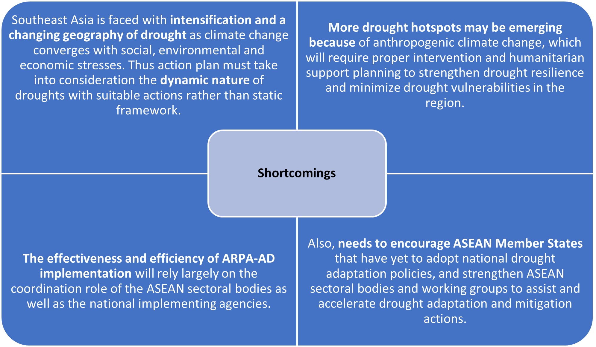
- The way forward:
- Ecosystem approach -international initiative on climate change, disaster management and biodiversity loss should have linkages and synergies with steps against drought and desertification.
- Ecosystem restoration through 3 Rs: Reclamation, Re-vegetation and Re-habilitation’.
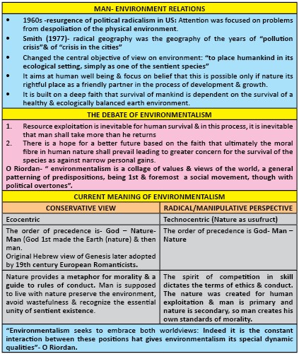
- Environmentalism approach- accord nature its right-full place as a friendly partner in the process of development and growth as survival of humankind is dependent on the survival of a healthy and ecologically balanced environment.
- Where this article can be used - Multi-level Planning, Sustainable Development, Limits to growth,Human ecology, Development strategies, Environmental Issues, Climate change in present times, Impact of climate change.
- Tags:UPSC, Geography, droughts in South-East Asia
Links
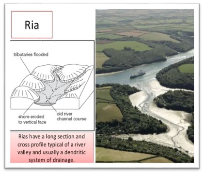
Ria Coast
Ria is a coastal formation (due to Submergence) that was once a river valley. It is found along an unglaciated land, which is an area that has not been formed by glaciers. A ria coast is a coastline that houses several ria formations. These rias run parallel to one another and are separated by a raised piece of land, or ridgeline.
Example: coast of south-west Ireland, Narragansett Bay, Rhode Island, USA.
Features of Ria coast
- Often, rias serve as the major drainage basin for the surrounding area.
- The drowning of river valleys along a stretch of coast and formation of rias results in an extremely irregular and indented coastline.
- A Ria coast differ from the fiords in two ways viz. they are not glaciated, & their depth increases seaward.
- All rias are generally backed by highlands & support few large commercial ports & extensively used for sitting fishing ports & naval bases.
Sources:
Sastrugi
Sastrugi, or zastrugi, are features formed by erosion of snow by wind. They are erosional bedforms scoured into hardened snow. They are distinguished by regular points that face into the wind. They may retreat downwind.
Sastrugi are the most widespread snow bedforms and cover much of Antarctica and Greenland.
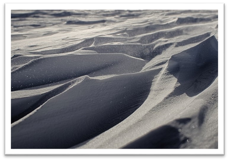
Key Features:
- They are found in Polar Regions, and in snowy, wind-swept areas of temperate regions, such as frozen lakes or mountain ridges.
- Sastrugi are more common on old surfaces than young ones because they do not devolve into other bedforms.
- Sastrugi grow out of transient bedforms that are shaped by multiple processes.
- Large sastrugi are troublesome to skiers and snowboarders.
Sources:
Pradhan Mantri Krishi Sinchai Yojana
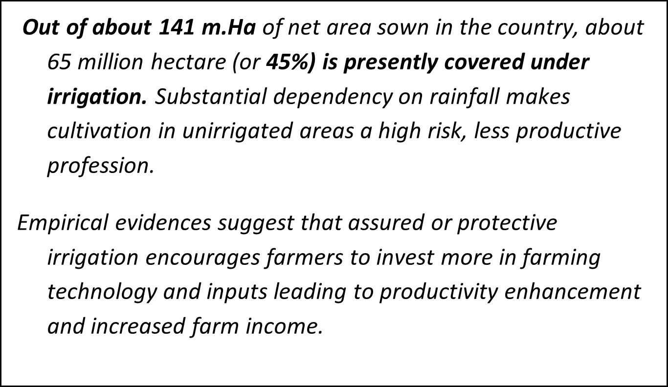
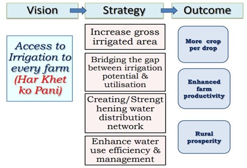
PMKSY was initiated in 2015 with an aim to enhance physical access of water on farm and expand cultivable area under assured irrigation, improve on-farm water use efficiency, introduce sustainable water conservation practices, etc.
It is an umbrella scheme, consisting of two major components being implemented by this Ministry, viz., Accelerated Irrigation Benefits Programme (AIBP), and Har Khet Ko Pani (HKKP).
Objectives
- Convergence of investments in irrigation at the field level (prepare district and sub district level water use plans).
- Har Khet Ko Pani: Enhance physical access of water on the farm and expand cultivable area under assured irrigation.
- More Crop Per Drop: Enhance the adoption of precision - irrigation and other water saving technologies.
- Integration of water source, distribution and its efficient use, to make best use of water through appropriate technologies and practices.
- Improve on - farm water use (OFWU) efficiency to reduce wastage and increase availability both in duration and extent.
- Enhance recharge of aquifers and introduce sustainable water conservation practices.
- For rainfed areas, use watershed approach towards soil and water conservation, arresting runoff, providing livelihood etc.
- Explore the feasibility of reusing treated municipal waste water for peri - urban agriculture.
- Attract greater private investments in irrigation.
- It uses area development approach; adopting decentralized state level planning i.e. States can make their irrigation development plans and take up projects.
Sources:
CASE STUDY – Odi River Revival
- BACKGROUND:
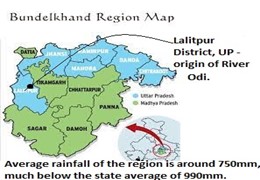
- Origin of river- Lalitpur district, Bundelkhand region, Uttar Pradesh.
- Average rainfall of the region is around 750 mm, much below the state average of 990 mm.
- Development of large dams and changing water regimes resulted in
- Accumulation of silts in check dams resulting in changes in channel morphology of river losing it natural form and force.
- Drop in water table.
- Water scarcity for agriculture, food resulting in livelihood crises (LC).
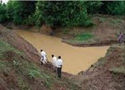
- PLAN OF ACTION:
- 3 Step Revival plan was implemented under the MGNREG Act:
- Removal of silt from the check dams
- Identification of 42 points for increasing the depth of the river.
- Silt collected from the check dams was used to build embankments.
- 3 Step Revival plan was implemented under the MGNREG Act:
- RESULTS:
- Water Availability-
- Villages on river course now have water throughout the year.
- Downstream, the Odi river now recharges wells and ensures functional hand-pumps throughout the yea
- Agriculture-
- The river irrigates nearly 3,885 hectares (ha) and 283 ha of barren land have been made fertile.
- Farmers can irrigate their fields three to four times for one crop, resulting in increased production by 20–50%.
- Farmers are able to increase cropping intensity (double cropping) and cultivate water-intensive crops like vegetables.
- Allied activities- Water and fodder are available for cattle.
- Progress- The increased yield has raised the average income of a farming family to R68,000 from R40,200 a year. Thus improving socio economic indicators of the region.
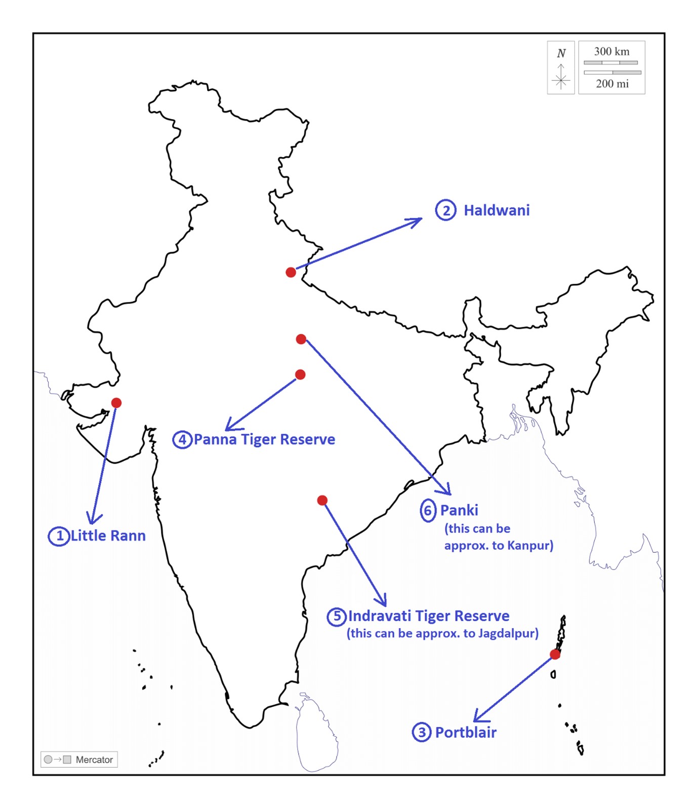
Little Rann
|
Little Rann
|
|
Haldwani
|
|
Portblair
|
|
Panna Tiger Reserve
|
|
Indravati Tiger Reserve
|
|
Panki
|
Share the article
Get Latest Updates on Offers, Event dates, and free Mentorship sessions.

Get in touch with our Expert Academic Counsellors 👋
FAQs
Geography Current Affairs focuses on the contemporary issues, events, and developments in the field of geography. It covers recent geographical phenomena, environmental changes, geopolitical shifts, and related news. This differs from regular geography studies which may focus more on foundational concepts, historical contexts, and theoretical frameworks.
Updates are provided regularly to ensure that subscribers stay informed about the latest developments in geography. Typically, updates are provided on a fortnightly basis, depending on the frequency of significant events and changes in the field.
Absolutely. Geography Current Affairs serves as a valuable resource not only for Geography optional but also for GS papers, especially GS Paper 1 (covering Indian Heritage and Culture, History, and Geography of the World and Society) and GS Paper 3 (covering Technology, Economic Development, Biodiversity, Environment, Security, and Disaster Management). It aids in building a holistic understanding of various topics and strengthens answer-writing skills by incorporating contemporary examples and perspectives.
Geography Current Affairs holds immense importance for UPSC preparation, particularly for aspirants opting for Geography optional. It helps candidates stay updated with the latest developments, geographical phenomena, environmental issues, and geopolitical shifts worldwide, aligning them with the dynamic nature of the subject as tested in the UPSC examinations.

