
24 Jul to 10 Aug, 2025
STATE OF FOOD SECURITY AND NUTRITION 2025
Why in news ?
The State of Food Security and Nutrition in the World (SOFI) 2025 report, shows global hunger dipped to 673 million, but India still has the highest number of wasted children under five.
Background :
The global assessment of the state of food security and nutrition is a snapshot of the world still recovering from a global pandemic and now grappling with the consequences of the war in Ukraine, which has rattled food and energy markets. Encouraging signs of economic recovery from the pandemic and projections of a decline in poverty and hunger have been tempered by rising food and energy prices.
About :
Food security and nutrition are crucial aspects of global well-being and development. They refer to the availability, accessibility, utilization, and stability of food and the nutritional status of individuals and populations.

Urbanization and Food Insecurity
- Changing Dietary Patterns: Urbanization often brings changes in dietary preferences and consumption patterns. As people move from rural to urban areas, their diets may shift towards more processed and calorie-dense foods, high in sugars, unhealthy fats, and salt. This transition is influenced by factors like increased availability of convenience foods, aggressive marketing by food industries, and changing lifestyles.
- Fragmentation of Food Supply Chains: As cities expand, they often become more complex, leading to the fragmentation of food supply chains. This can result in increased transportation distances, delays, and higher costs, affecting the affordability and accessibility of nutritious food, particularly for low-income urban populations.
- Socioeconomic Disparities: Urbanization can exacerbate socioeconomic disparities, leading to unequal access to healthy diets. Low-income populations in urban areas may face financial constraints that limit their ability to afford nutritious food. Moreover, urban food environments often have price differentials, with healthier food options being relatively more expensive compared to less nutritious alternatives.
Climate change and Food Insecurity
- Crop Production: Climate change affects agricultural productivity by altering temperature and precipitation patterns. Rising temperatures can lead to heat stress, reduced crop yields, and changes in planting and harvesting seasons.
- Pests and Diseases: Climate change influences the distribution and prevalence of pests, diseases, and invasive species that can harm crops and livestock. This increases the risk of crop and livestock losses, further threatening food security.
- Displacement and Migration: Climate change-induced events, such as droughts, floods, and storms, can lead to forced displacement and migration. Communities affected by these events often face challenges in accessing food and other basic necessities.
Conflict , Political Instability and Food Insecurity
- Restricted Access to Agricultural Inputs and Markets: Conflict and political instability can restrict farmers' access to essential agricultural inputs such as seeds, fertilizers, and pesticides. Markets may be disrupted, preventing farmers from accessing necessary supplies and selling their produce. Trade restrictions, road blockades, and insecurity can impede the movement of goods, including food, exacerbating food insecurity.
- Disrupted Markets and Inflation: Conflict disrupts market systems, leading to price volatility and inflation. Trade routes may be disrupted, making it challenging to import and distribute food. Disruptions in supply chains and market systems can lead to significant price increases, making food unaffordable for many vulnerable populations, particularly those living in poverty.
- Disrupted Humanitarian Assistance: Conflict and political instability can hamper the delivery of humanitarian assistance, including food aid. Insecurity, limited access to affected areas, and logistical challenges can hinder the timely and effective delivery of food assistance to populations in need.
Global Trade , Market Dynamics and Food Insecurity:
- Price Volatility: Fluctuations due to global trade and market dynamics in commodity prices, driven by factors such as weather conditions, supply and demand imbalances, and speculation, can significantly impact food security.
- Export-Oriented Agriculture: Some countries prioritize export-oriented agriculture, focusing on producing crops for the global market rather than for domestic consumption. When export-oriented agriculture takes precedence, it can disrupt local food systems and contribute to food insecurity, especially if there is a lack of diversification in agricultural production.
- Trade Liberalization and Market Distortions: Removal of trade barriers without adequate safeguards can expose vulnerable domestic food producers to unfair competition from highly subsidized foreign imports. This can lead to a decline in domestic agricultural production, loss of livelihoods, and reduced food availability.
Food Insecurity in Covid 19 pandemic and Russia Ukraine war
COVID-19 Pandemic
- Disruptions in the food supply chain resulted in labor shortages, transportation disruptions, and reduced access to inputs, leading to disruptions in agricultural production, processing, and distribution.
- School closures during the pandemic disrupted school feeding programs, depriving millions of children of nutritious meals they relied on. This had adverse effects on their nutrition and overall well-being.
- Export restrictions imposed by some countries like Russia to secure domestic food supply further strained global food markets.
Russia Ukraine war
- The conflict between Russia and Ukraine led to significant displacement of people from conflict-affected regions. Displaced populations face challenges in accessing food and income-generating opportunities, leading to heightened food insecurity.
- The war resulted in the destruction of agricultural infrastructure, including farms, storage facilities, and irrigation systems.
- The conflict disrupted trade flows and market systems, making it difficult to transport and distribute food.
|
CASE STUDY : FOOD INSECURITY AND SHORTAGE IN SOUTH SUDAN, 2017 For South Sudan, a triangle of misery confronts families as people struggle with conflict, poverty and the effects of climate change. Causes of malnutrition in South Sudan include mass displacement, increased Inflation, deep economic recessions, unemployment, climate change and eroded finances for social protection and health. Over 4 million people – 1 in 3 – have been forced to flee their homes due to the food crisis. Nearly 2.5 million have fled to neighboring countries. There were 1 million South Sudanese refugees in Uganda, making up about half of the country’s total refugee population. |

CONSEQUENCES OF FOOD INSECURITY AND NUTRITION
- Malnutrition and Health Issues: Food insecurity often leads to inadequate access to nutritious and diverse food, resulting in malnutrition. This can lead to communicable diseases like diarrhea, measles , bowel syndrome and intestinal failure.
- Economic Consequences: Food insecurity reduces productivity , limits ability to work, trapped people in poverty and hinder economic opportunities.
- Social and Political Instability: In times of severe food insecurity, social unrest can arise as populations protest against food shortages, price hikes, or unequal distribution of resources. Eg. Pakistan Competition for scarce resources, including food and water, can exacerbate existing tensions and lead to social upheaval. Eg. Syria unrest.
- Intergenerational Effects: Malnourished mothers are more likely to give birth to undernourished children, continuing the cycle of poor nutrition and its associated consequences.
GLOBAL INITIATIVES TO ADDRESS FOOD INSECURITY
- United Nations Sustainable Development Goals (SDGs): The SDGs, adopted by UN member states in 2015, include Goal 2: "Zero Hunger," which aims to end hunger, achieve food security, improve nutrition, and promote sustainable agriculture.
- Global Agriculture and Food Security Program (GAFSP): The GAFSP is a public-private partnership that provides financial support to low-income countries for agriculture and food security programs.
- Zero Hunger Challenge: Zero Hunger Challenge calls for an end to hunger, malnutrition, and food insecurity. It promotes sustainable agriculture and resilient food systems to achieve the goal of zero hunger.
- Global Alliance for Improved Nutrition (GAIN): An international organization that works to improve nutrition and public health by partnering with businesses, governments, and civil society.
Initiatives to ensure food security in India :
- NFSA act 2013: To provide subsidized food grains to approximately two thirds of the country’s people. It includes the Midday Meal Scheme, Integrated Child Development Services scheme and the Public Distribution System.
- Integrated Child Development Services (ICDS): It is the most visible symbol of the country’s commitment to its children and nursing mothers, as a response to breaking the malnutrition food cycle, morbidity, reduced learning capacity, and mortality on the other.
- The Integrated Scheme of Oilseeds, Pulses, Oil Palm and Maize (ISOPOM): Introduced in 2010 in 14 main states for the production of oilseeds, maize and oil palm to serve as a tool for crop diversification.
- Poshan Abhiyaan : Poshan Abhiyaan, also known as the National Nutrition Mission (NNM), was launched to reduce the level of under-nutrition and also enhance the nutritional status of children in the country.
WAY FORWARD
- Sustainable Agricultural Practices: Promote climate-smart agriculture such as agroforestry, encourage organic farming practices that minimize the use of synthetic inputs, conserve soil health, and promote biodiversity.
- Social Safety Nets and Nutrition Programs: Implement social protection programs, including cash transfers and food assistance, to ensure vulnerable populations have access to sufficient and nutritious food.
- Fortification of government distributed food: Boost the nutritional value of the Government’s Midday Meal school feeding programme, rice fortification with iron to tackle anemia.
- Enhancing Market Access and Trade: Reduce trade barriers and promote fair trade practices to facilitate the movement of food across borders and ensure equitable access to markets.
- Research, Innovation, and Technology: Promote the use of digital technologies, such as remote sensing, precision agriculture, and mobile applications, to improve farming practices, data collection, and market access.
Where to use ?
Paper I ( Geography optional ) : Food and nutrition problems, Food security
Source :
https://www.fao.org/statistics/events/detail-events/en/c/1642435/
EARTHQUAKE IN KAMCHATKA PENINSULA
Why in news : Recently, a high magnitude earthquake struck the Kamchatka Peninsula, triggering a tsunami that hit several countries on both sides of the northern Pacific Ocean.
About :
An 8.8 magnitude earthquake struck the Kamchatka Peninsula in Russia's Far East, triggering a tsunami affecting multiple countries across the northern Pacific Ocean.
Seismic Context
- The Kamchatka earthquake was the strongest since the 9.1 magnitude quake in Japan in 2011.
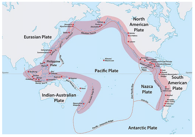
- This region falls along the Circum-Pacific seismic belt, commonly known as the "Ring of Fire".
- The Ring of Fire is responsible for over 80% of the world's largest earthquakes.
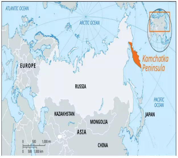
Geography of Kamchatka Peninsula
- It is a large peninsula in the Russian Far East, located between the Sea of Okhotsk to the west and the Pacific Ocean and Bering Sea to the east.
- Mountain Ranges - The Sredinny and Vostochny that run along its length.
- Kamchatka River - It flows through a valley separating the two main mountain ranges.
- Volcanoes - Kamchatka is known for its high density of volcanoes, with about 160 volcanoes, including 29 active volcanoes.
- Many are included in the Volcanoes of Kamchatka UNESCO World Heritage Site.
- Glaciers - The higher parts of Kamchatka are glaciated.
- Kuril-Kamchatka Trench - Immediately offshore of the peninsula and below the Bering Sea runs the 9,600-meter-deep Kuril–Kamchatka Trench.
- Siesmic activity - It lies on the Circum-Pacific seismic belt, more popularly known as the “Ring of Fire”.
Why the Pacific Ring of Fire is Highly Vulnerable to Earthquakes and Tsunamis
- The Pacific Ring of Fire is a horseshoe-shaped belt (~40,000 km) encircling the Pacific Ocean, hosting ~75% of the world’s active and dormant volcanoes.
- It is also the most seismically active region on Earth, accounting for ~90% of global earthquakes and the majority of tsunami events.
- Its extreme vulnerability is rooted in plate tectonic interactions—particularly subduction zones, transform faults, and volcanic arc systems.
(a) Geographic & Tectonic Basis of Vulnerability
- Plate Boundary Concentration
- The Ring of Fire coincides with convergent and transform plate boundaries—places of maximum lithospheric stress.
- Convergent boundaries (subduction zones) dominate, where an oceanic plate sinks beneath a continental or another oceanic plate, generating both megathrust earthquakes and tsunami-triggering vertical displacements.
Examples:
- Japan Trench – Pacific Plate subducting beneath the North American Plate → 2011 Tōhoku earthquake (Mw 9.1) & tsunami.
- Peru–Chile Trench – Nazca Plate subducting beneath South American Plate → 1960 Valdivia earthquake (Mw 9.5, largest recorded).
(b) Elastic Rebound & Strain Accumulation
- According to Elastic Rebound Theory, tectonic plates get locked at subduction interfaces, storing massive elastic strain, which is eventually released as high-magnitude quakes.
- Subduction megathrusts here are longer and deeper than in most other regions, allowing Mw > 8.5 earthquakes to occur.
(c) Island Arc Systems & Volcanic Chains
- The volcanic arcs (e.g., Aleutian, Mariana, Kuril, Philippines, Sunda) are directly above subduction zones where magma generation also coincides with earthquake foci.
- Volcanic flank collapses and submarine landslides here can trigger local tsunamis (e.g., 1883 Krakatoa eruption).
(d) Bathymetric & Coastal Topography
- Many Ring of Fire coastlines are narrow, funnel-shaped bays (fjords in Alaska, rias in Japan, island chains in Indonesia), which amplify tsunami wave height due to wave shoaling.
- Steep submarine slopes also promote submarine landslides post-earthquake, further intensifying tsunami hazards.
(e) Chain Reaction Events
- Earthquake → Landslide → Tsunami → Volcanic activity → Secondary tsunamis.
- Example: 1998 Papua New Guinea tsunami was triggered not by direct seabed uplift but by an earthquake-induced submarine landslide.
Geographic Concepts Linking to Vulnerability
- Plate Tectonics Theory – explains convergence/subduction.
- Seismic Gap Theory – predicts high risk in segments with long quake dormancy.
- Wave Shoaling Principle – explains tsunami amplification in shallow coasts.
- Hazard-Risk-Vulnerability Framework – high hazard + high exposure (dense coastal population) + variable preparedness = extreme vulnerability.
MEASURES TO COMBAT MENACE
1. Technological & Model-Based Solutions
- Tsunami Early Warning Systems (TEWS)
- Concept: Detect seismic activity + model tsunami propagation in real-time.
- Core Technology:
- Seismic Networks – High-sensitivity accelerometers & GPS strain meters (detect Mw > 6.5 quakes within seconds).
- DART Buoys (Deep-ocean Assessment and Reporting of Tsunamis) – Pressure sensors detect wave height changes in open ocean.
- Satellite Communication Links – Instant relay of data to forecasting centers.
- Example:
- Japan’s Nationwide System – Detects tsunamis in under 3 min post-quake.
- U.S. NOAA Pacific Tsunami Warning Center (PTWC) – Covers Pacific & Caribbean.
- Tsunami Numerical Modeling
- Models Used:
- COMCOT, MOST, TUNAMI-N2 – simulate tsunami travel time, wave height, inundation mapping.
- GIS-based Vulnerability Mapping – overlays hazard maps with population, infrastructure, and evacuation routes.
- Example: Indonesia’s InaTEWS uses real-time GPS + bathymetric modeling to predict inundation zones.
- Models Used:
- Structural & Coastal Defense Measures
- Seawalls & Breakwaters – Reduce tsunami wave height (e.g., Kamaishi Seawall, Japan – 63 m deep, though overtopped in 2011).
- Mangrove & Coral Reef Restoration – Nature-based solutions; studies show 30–50% reduction in wave energy.
- Elevated & Earthquake-Resistant Infrastructure – Raised evacuation shelters in Aceh, Indonesia.
- Offshore Artificial Reefs – Reduce kinetic energy of incoming tsunami waves.
- Land-Use & Zoning Policies
- Coastal setback laws → no construction in high-inundation risk areas.
- Relocation of critical facilities (hospitals, power plants) to higher ground.
- Example: Post-2004, Sri Lanka implemented a 100 m buffer zone along affected coasts.
2. Global Initiatives
|
Initiative |
Scope & Objective |
Key Features |
|
UNESCO Intergovernmental Oceanographic Commission (IOC) – Tsunami Programme |
Global |
Coordinates Pacific Tsunami Warning System (PTWS), Indian Ocean Tsunami Warning and Mitigation System (IOTWS), Caribbean Early Warning System |
|
Sendai Framework for Disaster Risk Reduction (2015–2030) |
UN-led |
Focus on early warning, community preparedness, resilient infrastructure |
|
Pacific Tsunami Warning Center (PTWC) |
Global Pacific |
Real-time quake & tsunami alerts, forecasting, training |
|
Indian Ocean Tsunami Warning & Mitigation System (IOTWS) |
28 countries |
Post-2004 system with seismic monitoring + DART buoys |
|
Global Seismographic Network (GSN) |
150+ stations worldwide |
High-precision seismic data for global hazard monitoring |
3. National-Level Initiatives (India)
- Indian National Centre for Ocean Information Services (INCOIS)
- Operates Indian Tsunami Early Warning Centre (ITEWC) in Hyderabad.
- Network of bottom pressure recorders, tide gauges, seismic stations.
- Can issue alerts within 10–12 minutes after an earthquake in Indian Ocean.
- National Disaster Management Authority (NDMA) – Coastal evacuation drills, public awareness campaigns.
- Coastal Regulation Zone (CRZ) Notification – Restricts infrastructure in vulnerable coastal zones.
- Sagar Vani Mobile App – Real-time ocean state and hazard information.
4. Innovative Technological Ideas for the Future
- AI & Machine Learning Models – Predict tsunami impact faster by learning from historical seismic + bathymetric data.
- Underwater Fiber-Optic Cables as Seismic Sensors – Dual use for internet + earthquake detection (Google/Caltech pilot projects).
- Drone-Based Rapid Damage Assessment – For post-tsunami relief and mapping inundation extent.
- Community IoT Warning Networks – Solar-powered sirens linked to early warning centers for rural coasts.
- Mobile-Based "Last-Mile" Alerting Systems – Using cell broadcast tech to reach even basic-feature phones.
Where to use :
Multi Modal Transit
Multi Modal Transit : Multi-modal transit refers to an integrated transportation system that combines different modes—such as buses, metro rail, cycling, and walking—to provide seamless, efficient, and sustainable mobility. It reduces reliance on private vehicles, cuts greenhouse gas emissions, and optimises land use. In environmental planning, it promotes low-carbon urban transport networks, encouraging public transport adoption and reducing congestion, air pollution, and energy consumption in cities.
Planetary Boundaries - 10th August 2025
Planetary Boundaries : Planetary Boundaries, proposed by Johan Rockström (2009), define nine ecological limits within which humanity can safely operate, such as climate change, biodiversity loss, and nitrogen cycles. Crossing these thresholds risks destabilising Earth’s life-support systems. The framework guides sustainable development by quantifying environmental limits, helping policymakers avoid tipping points that could cause irreversible ecological damage and threaten global stability.
Rewilding
Rewilding : Rewilding is a conservation strategy that restores ecosystems to their natural state by reintroducing native species, removing human-made barriers, and allowing natural processes to shape the landscape. It enhances biodiversity, strengthens ecosystem resilience, and supports carbon sequestration. Examples include wolf reintroduction in Yellowstone or wetland restoration in Europe, aiming to reverse habitat fragmentation and counteract the impacts of industrialisation and urbanisation.
Commensalism
Commensalism : Commensalism is a type of ecological interaction in which one species benefits while the other is neither harmed nor helped. In environmental science, examples include barnacles attaching to whales for transport or epiphytic plants growing on trees for sunlight. Such relationships contribute to ecological diversity and stability without imposing a cost on the host organism, highlighting the complexity of natural ecosystems.
ARAL SEA (CENTRAL ASIA)
The Aral Sea lay between present-day Kazakhstan and Uzbekistan, fed primarily by two rivers: the Amu Darya and Syr Darya.
In the 1950s the Aral Sea was one of the world’s largest inland lakes (order of magnitude ~60–70 thousand km² surface area historically).
Over 50–60 years it experienced catastrophic shrinkage due to large-scale diversion of its feeder rivers for irrigated agriculture (mainly cotton) under Soviet planning.
Surface area decline: from tens of thousands km² (≈60–70k km² mid-20th century) to a small fraction by early 21st century — the sea split into separate smaller basins (Northern and Southern Aral) and in many years >80–90% volume loss is reported in literature.
Water volume loss: on the order of ~80–90% decline compared with mid-20th century estimates (orders of magnitude).
Salinity rise: salinity increased manyfold, converting a freshwater/brackish ecosystem into a hyper-saline environment unsuitable for native freshwater fish.
Fisheries collapse: fishing towns that once supported thousands of fishers lost their livelihoods — fish species richness dropped sharply; commercial catches fell to near zero before partial local recoveries where water restored.
Where to use
Paper I ( Geography Optional ) : Regional Planning
Paper II ( Geography Optional ) : Human and ecological changes , Environment conservation
Places in News - 10 August 2025
1. Sharavathi Hydroelectric project
Why in news : Sharavathi Pumped Storage Hydroelectric Project in Karnataka has got in-principle approval from the National Board for Wildlife (NBWL), despite ecological concerns over its impact on the Sharavathi Valley Lion-tailed Macaque Sanctuary in the Western Ghats.
About :
- It is a pumped storage power project on the Sharavathi River in Karnataka.
- The Sharavathi River serves as a crucial source of hydroelectric power in Karnataka, and this project, with its planned total power generation capacity of 2000 MW, stands as the largest pumped storage power generation unit in the country
- Modelled on the lines of Telangana’s Kaleshwaram project, it also aims to supply drinking water to Bengaluru.
- Five tunnels and eight pumping stations are critical parts of the plan .
- Approx : Shimoga
2. Puga valley
Why in news : Scientists in Puga Valley hot springs, Ladakh, discovered travertine (calcium carbonate) deposits capable of trapping organic molecules like amino acids, fatty acids, and formamide.
About :
- Puga Valley is situated in the Changthang Valley in the south-eastern part of Ladakh, about 22 km away from the Salt Lake Valley.
- It is a region of great significance known for its natural beauty and geothermal activities.
- Puga is also visited for its hot sulphur spring.
- Approx : Ladakh
3. Kadmat
Why in news : A study tracking coral health at three major atolls —Agatti, Kadmat, and Kavaratti—has revealed alarming findings, showing a 50% decline in coral cover in the Lakshadweep reefs, from 37.24% in 1998 to 19.6% in 2022.
About :
- Situated in the Amindivi group of Lakshadweep islands, in the Arabian Sea.
- Popular for its beaches, water sports like snorkeling and scuba diving, and its serene environment.
- Characterized by a tropical climate with moderate temperatures and humidity.
- The islanders are primarily Muslim and follow traditional customs and practices.
- Kadmat has been recently connected with Kochi via a submarine optical fiber cable, enhancing communication and digital services
- Approx : Lakshadweep
4. Anamudi Shola National Park
Why in news : A road project through the Anamudi Shola National Park in Kerala's Idukki district has been stalled, impacting access to tribal settlements.
About :
- It is a biodiversity hotspot in the southern Western Ghats designated as a National Park in 2003, and forms part of the Anamalai sub-cluster, a UNESCO World Heritage Site.
- It is home to Anamudi (2,695 m) peak, (highest in South India), and is crucial for watershed conservation, forming the catchment area for rivers like the Pambar and Chinnar.
- A unique feature of the park is its dense shola forests, characterized by stunted trees and an abundant growth of lichens, mosses, and climbers.
- Approx : Idukki
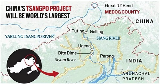
5. Gelling
Why in news : China is building a 60,000 MW hydropower project on the Yarlung Zangbo River (known as the Brahmaputra in India and Jamuna in Bangladesh) in Tibet, near Gelling in Arunachal Pradesh.
About :
- It is a village and the headquarters of an eponymous circle in the Upper Siang district in the Indian state of Arunachal Pradesh.
- The Brahmaputra River enters India near Gelling. Gelling village is located around 35 km upstream from Tuting.
- The Gelling Circle contains the basin of the Siang river on both the sides, on the border of the Medog County of China's Tibet Autonomous Region.
- Approx : Siang

Fortnightly KOSMOS MCQs Practice - 10th August 2025
Q1. ‘ Lone Pine Creek' , sometimes , mentioned in news is related to :
- Xerophyte species
- Wildfire
- Peatlands
- Cotton Grass
Q2. Consider the following pairs :
Mangroves : State
1. Dhamra mangroves : West Bengal
2. Coringa mangroves : Andhra Pradesh
3. Coondapur mangroves : Karnataka
4. Vaitarna mangroves : Maharashtra
Which of the above mentioned pairs are correct ?
- One pair
- Two pairs
- Three pairs
- Four pairs
Q3. Consider the following pairs :
Tiger reserve : State / Places
1. Pench Tiger reserve : Maharashtra
2. Amrabad Tiger reserve : Andhra Pradesh
3. Palamau : Chhattisgarh
4. Dandeli- Anshi. : Karnataka
Which of the above mentioned pairs are correctly matched ?
- One pair
- Two pairs
- Three pairs
- Four pairs
Q4. Which of the following statements about Bisphenol (BPA) is incorrect?
- Bisphenol (BPA) is commonly used in the production of certain types of plastics, such as polycarbonate and epoxy resins.
- BPA has been linked to potential health concerns, including its potential to mimic estrogen and disrupt hormonal balance.
- Bisphenol (BPA) is primarily used in the manufacturing of textiles and clothing materials.
- BPA exposure can occur through the consumption of certain food and beverage containers made with BPA-containing plastics.
Q5. Consider the following pairs :
Tribes : states
1. Limboo. : Sikkim
2. Karbi. : Himachal Pradesh
3. Dongaria Kondh. : Odisha
4. Bonda. : Tamil Nadu
Which of the above are correctly matched ?
- One pair
- Two pairs
- Three pairs
- Four pairs
Q6. Consider the following :
1. Ice cores
2. Tree Rings
3. Coral records
4. Pollen records
Which of above mentioned are used for “ Palaeo proxies “ or measurements of climate and environmental conditions ?
- Only one option is correct
- Only two options are correct
- Only three options are correct
- All four options are correct.
Q7. With reference to Western Tragopan , consider the following statements:
1. They are among the rarest of all living pheasants.I.e a large long tailed bird
2. The growing population of it signals climate change as they are known to grow and thrive in dry conditions.
Which of the above mentioned statements is / are correct ?
- Only 1
- Only 2
- Both 1 and 2
- Neither 1 nor 2
Q8. Consider the following :
1. Arunachal Pradesh
2. Manipur
3. Nagaland
4. Meghalaya
With reference to the states mentioned above , in terms of percentage of Forest cover to the total area of State , which one of the following is correct ascending order?
- 2-3-1-4
- 2-3-4-1
- 3-2-4-1
- 3-2-1-4
Q9. Which among the following are not included in process of carbon capture and storage ?
- Co2 is isolated from other gases generated during industrial processes or power generation.
- Co2 is compressed and transported to designated sites frequently through pipelines.
- Co2 injected into subterranean rocks , when it remains stored for extended periods.
- None of the above
Q10. Consider the following statements regarding Vultures :
1. Vultures thrive in densely forested habitats , where they primarily feed on carcasses.
2. Ketoprofen drug have been found to be harmful to vultures causing their death
Which of the above mentioned statements is/ are correct ?
- Only 1
- Only 2
- Both 1 and 2
- Neither 1 nor 2
Share the article
Edukemy’s Current Affairs Quiz is published with multiple choice questions for UPSC exams
MCQ
Get Latest Updates on Offers, Event dates, and free Mentorship sessions.

Get in touch with our Expert Academic Counsellors 👋
FAQs
Geography Current Affairs focuses on the contemporary issues, events, and developments in the field of geography. It covers recent geographical phenomena, environmental changes, geopolitical shifts, and related news. This differs from regular geography studies which may focus more on foundational concepts, historical contexts, and theoretical frameworks.
Updates are provided regularly to ensure that subscribers stay informed about the latest developments in geography. Typically, updates are provided on a fortnightly basis, depending on the frequency of significant events and changes in the field.
Absolutely. Geography Current Affairs serves as a valuable resource not only for Geography optional but also for GS papers, especially GS Paper 1 (covering Indian Heritage and Culture, History, and Geography of the World and Society) and GS Paper 3 (covering Technology, Economic Development, Biodiversity, Environment, Security, and Disaster Management). It aids in building a holistic understanding of various topics and strengthens answer-writing skills by incorporating contemporary examples and perspectives.
Geography Current Affairs holds immense importance for UPSC preparation, particularly for aspirants opting for Geography optional. It helps candidates stay updated with the latest developments, geographical phenomena, environmental issues, and geopolitical shifts worldwide, aligning them with the dynamic nature of the subject as tested in the UPSC examinations.