
24 May to 10 Jun, 2024
RANGE LANDS AND THEIR SIGNIFICANCE IN ENVIRONMENT
Why in news : About half of the world’s rangelands are degraded and need policy interventions, and communities depending on them need focused support, according to a new report of the United Nations Convention on Combating Desertification (UNCCD).
About :
Rangelands are vast natural landscapes that are primarily utilized for grazing livestock and wildlife. Rangelands are crucial for biodiversity conservation, carbon sequestration, and supporting livelihoods in many regions. They generate 16% of global food production and 70% of feed for domesticated herbivores, most significantly in Africa and South America.
Types of Rangelands
- Grasslands: Includes prairies, steppes, and savannas. These areas are dominated by grasses and have few trees. Examples: The Great Plains in North America, the Pampas in South America, the steppes of Central Asia.
- Shrublands: Characterized by the dominance of shrubs and small trees. Examples: The chaparral in California, the maquis in the Mediterranean region.
- Woodlands: Areas with widely spaced trees and an understory of grass and shrubs.Examples: The oak savannas of North America, the miombo woodlands in Africa.
- Deserts: Arid regions with sparse vegetation, including cacti and drought-resistant shrubs. Examples: The Sahara in Africa, the Mojave in North America.
Significance of Rangelands :
- Biodiversity Conservation : Rangelands support a diverse array of plant and animal species. Eg , the Serengeti in Tanzania is home to iconic wildlife such as wildebeests, zebras, and lions.
- Carbon Sequestration: According to the World Resources Institute, grasslands sequester about 10-30% of the world’s carbon stock in soil.
- Hydrological Cycle: The Pampas in Argentina are critical for the region’s water supply.
- Erosion Control: Vegetation in rangelands helps prevent soil erosion, maintaining soil health and reducing sedimentation in water bodies.
Social and Cultural Significance
- Indigenous Practices: The Maasai people of East Africa , have a deep cultural connection to their rangelands, which is reflected in their traditional pastoral practices.
- Sustainable Livelihoods: Programs that involve local communities in rangeland management, such as the Holistic Management approach in Zimbabwe, have shown positive outcomes in terms of both conservation and economic benefits .

How Global Change Affecting Rangelands ?
- Changes in Land Use and Productivity : In a 15 year period from 1982 to 1997,more than 12 million acres of privately held rangeland was shifted into urban development only in the USA.
- Overgrazing: The United Nations estimates that 70% of the world's drylands, including rangelands, are affected by land degradation .
- Invasive Species : In Northern Australia , gamba grass has led to more frequent and severe fires, endangering native woodlands and biodiversity, and posing risks to human settlements.
- Fragmentation : Fragmentation of rangelands due to roads, fences, and other infrastructure can disrupt wildlife migration routes and reduce the resilience of ecosystems.
- Loss of Traditional Knowledge : In East Africa, the loss of traditional Maasai grazing practices, which involve rotating livestock to prevent overgrazing, has led to land degradation.
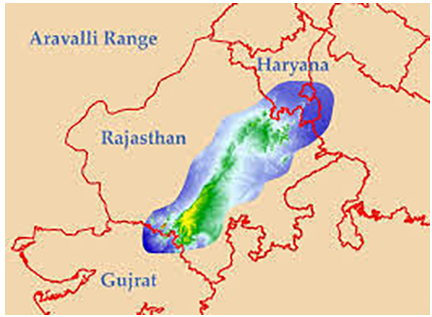
Rangelands in India
- In India, rangelands cover approximately 1.21 million square kilometers, stretching from the Thar Desert to the Himalayan meadows.
- They act as carbon sinks (which absorb more carbon from the atmosphere than they release), storehouses of freshwater, and prevent desertification of land. Millions of people worldwide depend on rangelands for food security, and livelihoods.
|
CASE STUDY OF RANGELAND MANAGEMENT IN RAJASTHAN IN INDIA According to a study by the Central Arid Zone Research Institute (CAZRI), areas under rotational grazing saw a 20% increase in grass biomass within two years . The Rajasthan Watershed Development Project reported a 30% increase in groundwater levels in areas with water harvesting structures. Removal of Prosopis juliflora and replanting with native grasses and shrubs. According to National Institute of Rural Development , surveys indicate that over 70% of households in project areas reported improved rangeland conditions and increased livestock productivity. The Rajasthan Livestock Development Board reported a 25% increase in milk yield and a 15% increase in livestock numbers in managed rangelands |


Key Highlights of UNCCD
- Approximately 50% of the world’s rangelands are classified as “degraded” and are in decline.
- Factors contributing to this degradation include climate change, unsustainable land and livestock management practices, biodiversity loss, and conversion of rangelands to farmlands.
- Uncertainty over land rights among pastoralist communities exacerbates degradation.
- Impact on Communities:
- Deterioration of rangelands adversely affects communities dependent on them.
- Consequences include reduced soil fertility, biodiversity loss, decreased incomes, and increased conflicts over grazing rights with authorities.
Mitigation Strategies
- Rotational Grazing : In Rajasthan, India, the Central Arid Zone Research Institute (CAZRI) implemented rotational grazing, resulting in a 20% increase in grass biomass within two years
- Invasive Species Control : In the Western United States, efforts to control cheatgrass (Bromus tectorum) have included mechanical removal and reseeding with native species.
- Soil Conservation Techniques : In Kenya, contour plowing and terracing in rangelands have reduced soil erosion by 50%, improving soil fertility and water retention.
- Community-Based Management : In Mongolia, community-based rangeland management has led to improved grazing practices and enhanced pasture conditions, with a 15% increase in livestock productivity.
Conclusion
Integrated climate change mitigation and adaptation strategies boost pastoralist resilience by reducing rangeland conversion and preserving their diversity and multifunctionality. Supporting pastoralism-based practices mitigates harm to rangeland health, fostering sustainable livelihoods and ecosystem balance.
Source :
CYCLONE REMAL AND DISASTER
Why in news : Cyclone Remal caused heavy rainfall, triggering landslides at several locations
About :
Major Disaster Threats in India
- Floods: States like Bihar ( 2023 ) and Assam ( 2022 ) are frequently experiencing floods during the monsoon season, and further exacerbated by Glacial Lake Outburst Floods.
- Cyclones and Storms: Cyclone Biporjoy ( 2023 ) and Cyclone Fani ( 2019) have already devastated and eroded the long vulnerable coastline of India.
- Earthquakes : Himalayan States like Mizoram , Sikkim are vulnerable to moderate to very high intensity earthquakes due to several fault lines.
- Droughts: Erratic rainfall and prolonged dry spells affect 68% of the cultivable area, leading to severe droughts. Eg Vidarbha in Maharashtra
- Heat Waves: : Nationwide heat waves (2022, 2023, 2024).
- Forest Fires: States like Odihsa and Uttarakhand are exposed to occasional fires due to dry conditions and human activities.

Why risk of Disasters is Increasing in India ?
- Urbanization and Unplanned Development: 2023 Chennai floods due to rampant development and encroachment
- Climate Change Impact: The devastation caused by Cyclone Renal has exceeded expectations, due to climate change
- Aging Infrastructure : Aging dams, bridges and building further increasing the risk
- Environmental Degradation: Land subsidence in Joshimath in 2023 due to unregulated construction and mining.
Measures to be Taken
- Promote Disaster-Resilient Infrastructure
- Develop Disaster-Resilient Agricultural Practices: Eg : Burkina Faso's Zai pit farming technique, to enhance soil moisture during droughts.
- Promote Ecosystem-based Disaster Risk Reduction (Eco-DRR): Sustainably managing natural ecosystems for carbon sequestration and biodiversity conservation benefits.
- Strengthen Multi-Hazard Early Warning Systems: Integrated early warning systems and timely alerts for multiple hazards.
- Mental Health Response Teams: Efforts to provide psychological support to survivors dealing with trauma, anxiety, and displacement.
- Enhanced Institutional Capacity: Local bodies should receive substantial Disaster Readiness Reserves to support proactive disaster measures.
India’s Initiatives for Disaster Management in India
- Disaster Management Act of 2005
- National Disaster Management Authority (NDMA)
- Cabinet Committee on Management of Natural Calamities (CCMNC)
International Initiatives
- Sendai Framework for Disaster Risk Reduction
- Hyogo Framework For Action
Conclusion :
Effective disaster management in India requires robust coordination between national, state, and local authorities, backed by comprehensive policies and frameworks. Emphasizing proactive measures like preparedness and mitigation, along with community involvement, is crucial.
Source :
Where to use :
Paper III (General Studies ) : Disaster Management
Paper II ( Geography Optional ) : Ecological issues and Environmental Hazards
URBAN SUSTAINABILITY
Why in news : Fires in Rajkot and Delhi have reignited the debate over the sustainability of urban areas in India.
About :
Major Challenges Related to Urban Spaces in India
- Inadequate Housing and Slum Proliferation : The urban housing shortage in India was around 18.78 million units between 2012-27, with over 65 million people living in slums or informal settlements (Ministry of Housing and Urban Affairs).
- Air Pollution and Environmental Degradation: According to the World Air Quality Report 2023, 9 of the top 10 most polluted cities are in India.
- Traffic Congestion and Mobility Challenges: In Bengaluru, the average traffic speed during peak hours is around 18 km/h, resulting in significant economic losses due to lost productivity and fuel wastage.
- Inadequate Solid Waste Management: According to the Central Pollution Control Board, Indian cities generate approximately 62 million tons of municipal solid waste annually, with only around 20% being processed or treated properly.
- Cybersecurity and Resilient Digital Infrastructure: The ransomware attack on AIIMS Delhi in 2022 highlights the vulnerability of urban digital systems.
- Water Scarcity and Inadequate Water Management: Chennai faced a severe water crisis in 2019, with residents relying on water tankers and desalination plants. Bengaluru also faced a significant water crisis recently.
- Urban Heat Island Effect and Lack of Green Spaces: The extreme heatwave in Delhi in May 2024 drove the city's power demand to a record high of over 8,000 megawatts.
Major Government Initiatives Related to Urban Areas
- Smart Cities : Aims to develop 100 smart cities with efficient urban infrastructure, sustainable environment, and high quality of life.
- AMRUT Mission : Focuses on providing basic services like water supply, sewerage, and urban transport in 500 cities.
- Swachh Bharat Mission-Urban : To make urban areas open defecation free and achieve 100% scientific waste management.
- Pradhan Mantri Awas Yojana-Urban : Aims to provide affordable housing to all urban poor by 2022.
- Aspirational District Programme : Aims to transform the quality of life in 112 backward districts.
Strategies to rejuvenate India's urban landscape
- Waste Management: Encourage small-scale waste-to-energy plants for renewable energy production.
- Water Management: Invest in wastewater treatment and recycling facilities for non-potable uses.
- Digital Urban Planning: Use predictive modeling and AI for data-driven decision-making and citizen engagement.
- Sponge City Concept: Preserve natural water bodies and wetlands for water retention and flood mitigation.
- Biophilic Design: Incorporate nature into urban architecture and infrastructure. Examples include green roofs and rain gardens.
- Smart City Infrastructure: Enhance citizen's quality of life and reduce carbon emissions.
- Fire Risk Management: Deploy sensors for real-time monitoring of air quality and fire risks.
- Cybersecurity: Implement robust cybersecurity measures and digital infrastructure resilience to protect against cyber threats and ensure continuity of essential services.
Conclusion :
To ensure urban sustainability, it is imperative to integrate smart technologies, promote efficient resource management, and prioritize green infrastructure. Community engagement and government collaboration are key, along with stringent policies for waste management, water conservation, and renewable energy adoption.
Source :
https://indianexpress.com/article/opinion/columns/rajkot-delhi-fires-safer-cities-9355131/
Where to use :
Paper I ( Geography Optional ) : Urban cities , Primate Cities
Paper II ( Geography Optional ) : Problems of urbanization and remedies
Vertical Wind shear
Vertical Wind shear : Vertical wind shear refers to the change in wind speed or direction with height in the atmosphere. Vertical wind shear is measured using radiosondes, wind profilers, Doppler radar, and other meteorological instruments. Tropical cyclones require low vertical wind shear to maintain their structure and intensify.
Sympatric Speciation
Sympatric Speciation : Sympatric speciation occurs when new species evolve from a single ancestral species while inhabiting the same geographic region. Sympatric speciation does not require large-scale geographic distance to reduce gene flow between parts of a population.
Oceanic Nino Index ( ONI )
Oceanic Nino Index ( ONI ): It is the primary indicator for monitoring the ocean part of El Niño-Southern Oscillation, or “ENSO”. The ONI tracks the running 3-month average sea surface temperatures in the east-central tropical Pacific between 120°-170°W, near the International Dateline.
Karman Line
Karman Line : It is an imaginary line located above 100km, demarcates the earth’s atmosphere from space. The line was established to regulate airspace and marks the altitude beyond which a traditional aircraft can't fly..
Bathymetry
Bathymetry : It is the study and mapping of the underwater topography of water bodies, such as oceans, rivers, lakes, and streams. It involves measuring the depth of the water and is similar to mapping the topography of land.
INTEGRATED COASTAL MANAGEMENT (ODISHA)
One third of the coastline of India is vulnerable to erosion and three states - West Bengal , Odisha and Gujarat are the most affected ones. Integrated Coastal Management programme in Odisha is backed by the World Bank with an aid of 800 crore rupees. Following are the steps taken:
- Geoengineering tubes are deployed near the coastal areas along the villages of Podampetti villages
- Hard engineering structures like walls and dykes have also been erected to withstand strong sea waves .
- Plantation of Mangrove species to prevent decline in number of Olive Ridley Turtles. Mangrove gene bank was also set up at Kendrapara district of Odisha .
- Local boats have been transformed into eco friendly boats to mitigate pollution.
- Nearly 3000+ volunteers have been trained to work as guards and tourist guide to prevent poaching activities.
![]()

Source :
https://www.osdma.org/integrated-coastal-zone-management-project/
Where to use ?
Paper II ( Geography Optional ) : Coastal Erosion
Paper I ( General Studies ) : Geographical features and their location , Important Geophysical Phenomena.
Places in the news
1. Ashtamudi lake
Why in the news : A recent study conducted by the “Department of Aquatic Biology and Fisheries”, University of Kerala, has revealed alarming levels of microplastic pollution in Ashtamudi Lake.
- Ashtamudi Lake is located in the Kollam district of Kerala.
- The lake is also called the “gateway to the backwaters of Kerala”.
- It is a brackish water lake, meaning it contains a mix of freshwater and saltwater.
- It covers an area of approximately 61 square kms (23.5 square miles).
- Kallada River is a major river discharging into the Ashtamudi Lake.
- Approx : Kollam
2. Gahirmatha Marine Sanctuary
Why in the news : Recently, the traditional Chinese sky lantern festival was scheduled near a nesting site of the endangered Olive Ridley turtles.
- It is a marine wildlife sanctuary located in Odisha and is a very popular tourist attraction of Odisha in India.
- It is the world's largest nesting beach for Olive Ridley Turtles.
- It extends from Dhamra River mouth in the north to Brahmani river mouth in the south.
- Approx : Kendrapara
3. Sundarbans National Park
Why in the news: The International Union for Conservation of Nature (IUCN) has issued a new report cautioning that half of the world's mangrove ecosystems are at risk of collapsing.
- It is situated in the coastal districts of West Bengal, i.e., South 24-Parganas and part of North 24-Parganas.
- It lies at the southernmost extremity of the lower Gangetic delta, bordering the Bay of Bengal.
- It is a part of the famous "Sundarbans," the largest delta in the world, formed by the convergence of two Himalayan rivers, the Ganga and the Brahmaputra, both of which flow into the Bay of Bengal.
- It is not only a Tiger Reserve but also a National Park and a Biosphere Reserve.
- Approx : 24 Paragnas
4. Hailakandi
Why in the news : Recently a landslide after Cyclone Remal has killed three persons in Hailakandi.
- It is a town and the district headquarters of Hailakandi district in the Indian state of Assam.
- Bengali and Meitei are the official languages of this place.
- Hailakandi's huge verdant tea gardens are a significant attraction. The Siddyashar Bari temple and Pach Pirr Mukam are also prominent attractions of the quaint town.
- Approx : Cachar hills
5. Karaivetti Bird Sanctuary
Why in the news : Karaivetti Bird Sanctuary in Ariyalur district, was recently recognised as a Ramsar site.
- The Site is one of the largest inland freshwater lakes in the State of Tamil Nadu.
- It provides an important stopover and foraging ground for birds migrating along the Central Asian Flyway.
- The Site also provides breeding habitat for the vulnerable Indian flap-shelled turtle.
- During the driest period, between July and October, the water level of the Site is maintained with water from the Mettur Dam.
- Approx : Thanjavur

Fortnightly KOSMOS MCQs Practice
Q1. Consider the following statements about Loss and Damages Fund :
- It is an initiative of the Convention of Biological Diversity .
- It is aimed to compensate for the losses incurred by communities, and ecosystems due to the impacts of climate change.
- It is coordinated by World Resources Institute (WRI) and World Business Council for Sustainable Development (WBCSD)
Select the correct answer using the code given below:
- 1 and 2 only
- 2 only
- 2 and 3 only
- 1, 2 and 3
Q2. With reference to heat waves, consider the following statements :
- Heat wave is considered if the maximum temperature of a station reaches at least 40°C or more for Plains and at least 30°C or more for Hilly regions.
- India is the only country in Asia, recognizing the heat waves as natural disaster .
Select the correct answer using the code given below:
- 1 only
- 2 only
- Both 1 and 2
- Neither 1 nor 2
Q3. Bridge fuel , sometimes in news is related with :
- Biofuels
- Petroleum
- Natural gas
- Fuel Cells
Q4. National Disaster Relief Funds, some time in news is monitored by which among the following ministries :
- Ministry of Home Affairs
- Ministry of Agriculture
- Ministry of Environment and Climate Change
- Both “ a” and “ b “
Q5. With reference to recently released data on forest by Global Forest Watch , consider the following
- Indonesia topped the ranking of tropical countries with the most primary forest losses.
- In India, Assam had the maximum tree cover loss at 324,000 hectares.
- Between 2001 and 2022, forests in India emerged as a net carbon sink .
How many of the above statements are correct ?
- Only one
- Only two
- All three
- None
Q6. Consider the following statements regarding Great Indian Bustards (GIBs):
Statement-I : The significant decline in the population of Great Indian Bustards (GIBs) is primarily due to frequent collisions with overhead power transmission lines.
Statement-II : Great Indian Bustards (GIBs) have lateral vision because their eyes are located on the sides of their heads, making it difficult for them to change their flight path when encountering a live wire.
Which one of the following is correct in respect of the above statements?
- Both Statement-I and Statement-II are correct and Statement-II is the correct explanation for Statement I
- Both Statement-I and Statement-II are correct and Statement-II is not the correct explanation for Statement-I
- Statement-I is correct but Statement-II is incorrect
- Statement-I is incorrect but Statement-II is correct
Q7. Consider the following statements regarding Caracal :
- They are considered harmful to marine organisms .
- They are the indicator species in the ecosystem
- They are nocturnal animals.
- It is listed in Schedule I of Wildlife protection Act , 1972
How many of the above statements are correct ?
- Only one ‘
- Only two
- Only three
- All four
Q8. Consider the following statements regarding Cicadas :
- Cicadas are insects that spend the majority of their lives underground, emerging primarily to mate.
- India and Bangladesh have the highest genetic diversity of cicadas in the world, followed by China.
Select the correct answer using the code given below:
- 1 only
- 2 only
- Both 1 and 2
- Neither 1 nor 2
Q9. Consider the following statements regarding Swell Waves:
- It is the formation of long wavelength waves on the surface of the seas.
- They occur under the influence of the local winds.
- They sometimes even occur in enclosed or partially enclosed bodies of water
How many of the above statements are correct ?
- Only one
- Only two
- Only three
- None
Q10. Consider the following statements:
Statement-I: India's effort to enhance early warning systems emphasizes the significance of international collaboration in tackling the increasing risks posed by natural disasters and climate change.
Statement-II: According to a report by the World Meteorological Organization (WMO), natural disasters have increased more than fivefold from 1970 to 2019, with water-related disasters being the most common worldwide.
Which one of the following is correct in respect of the above statements?
- Both Statement-I and Statement-II are correct, and Statement-II is the correct explanation for Statement-I.
- Both Statement-I and Statement-II are correct, and Statement-II is not the correct explanation for Statement-I.
- Statement-I is correct, but Statement-II is incorrect.
- Statement-I is incorrect, but Statement-II is correct.
Share the article
Edukemy’s Current Affairs Quiz is published with multiple choice questions for UPSC exams
MCQ
Get Latest Updates on Offers, Event dates, and free Mentorship sessions.


Get in touch with our Expert Academic Counsellors 👋
FAQs
Geography Current Affairs focuses on the contemporary issues, events, and developments in the field of geography. It covers recent geographical phenomena, environmental changes, geopolitical shifts, and related news. This differs from regular geography studies which may focus more on foundational concepts, historical contexts, and theoretical frameworks.
Updates are provided regularly to ensure that subscribers stay informed about the latest developments in geography. Typically, updates are provided on a fortnightly basis, depending on the frequency of significant events and changes in the field.
Absolutely. Geography Current Affairs serves as a valuable resource not only for Geography optional but also for GS papers, especially GS Paper 1 (covering Indian Heritage and Culture, History, and Geography of the World and Society) and GS Paper 3 (covering Technology, Economic Development, Biodiversity, Environment, Security, and Disaster Management). It aids in building a holistic understanding of various topics and strengthens answer-writing skills by incorporating contemporary examples and perspectives.
Geography Current Affairs holds immense importance for UPSC preparation, particularly for aspirants opting for Geography optional. It helps candidates stay updated with the latest developments, geographical phenomena, environmental issues, and geopolitical shifts worldwide, aligning them with the dynamic nature of the subject as tested in the UPSC examinations.