24 Aug to 10 Sep, 2024
CLIMATE TIPPING POINTS
Why in news : As global temperatures continue to rise, businesses face an increasingly urgent challenge: adapting to the risks posed by climate tipping points.
About :
What are Climate Tipping Points ?
According to IPCC, tipping points are ‘critical thresholds in a system that, when exceeded, can lead to a significant change in the state of the system, often with an understanding that the change is irreversible.’
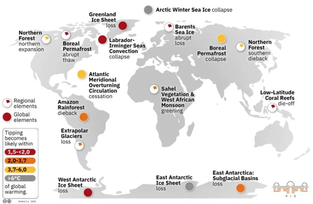
What evidence do we have that tipping points exist?
- Greenland Ice Sheet Melting : Ice sheet is losing around 280 billion tons of ice per year, contributing to about 0.8 mm of global sea level rise annually.
- Thawing of Permafrost : The Arctic region contains about 1,700 gigatons of carbon in permafrost, nearly twice the amount currently in the atmosphere. A 2°C increase could release vast amounts of methane.
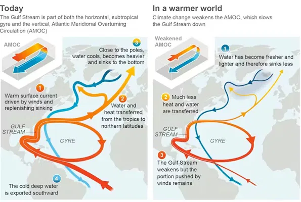
- Collapse of the Atlantic Meridional Overturning Circulation (AMOC) : Weakening or collapse of AMOC could cause extreme cooling in Europe, disrupt monsoons, and trigger more frequent heatwaves in the U.S.
- West Antarctic Ice Sheet Instability : Thwaites Glacier alone contributes about 4% of annual sea-level rise, and its complete collapse could lead to an additional rise of over 2 meters.
Climate tipping points interactions with Earth Climate System
- Albedo Feedback : As Arctic sea ice melts due to global warming, the Earth's albedo (reflectivity) decreases, causing more solar radiation to be absorbed by the darker ocean surface. This amplifies warming, creating a feedback loop that further accelerates ice melt and raises global temperatures.
- Disruption carbon cycle : Estimate suggest that once 20-25% of the Amazon is deforested, the system may no longer support the humid, rainforest conditions and could enter a state of irreversible dieback. Dieback could release this stored carbon, exacerbating climate change.
- Indian Monsoon Shift : As the global climate warms, the differential heating balance is altered, leading to changes in wind patterns and moisture availability. This affects not only the regional climate of South Asia but also the global atmospheric circulation.
- Expansion of Subtropical Deserts : The Sahara Desert has been expanding southward into the Sahel region, leading to increased desertification and a loss of arable land.
Climate Tipping Point and other mechanisms
- Disruption of Heat Budget : The Arctic’s temperature is rising nearly three times faster than the global average, leading to significant changes in the heat budget of the region.
- Atmospheric instability : Hurricane intensity has been shown to increase with ocean temperature; the 2020 Atlantic hurricane season recorded 30 named storms, the highest number in history.
- Weak Polar Jet Streams : Weakening jet stream could become a permanent feature, resulting in increased weather extremes globally.
- Ocean Acidification : The pH of the ocean has dropped by 0.1 units since the industrial revolution, representing a 30% increase in acidity. Incidences like Coral Bleaching is common.
- Hydrological cycle : Collapse of ice sheets contributes to sea-level rise, which can contaminate freshwater aquifers with saltwater intrusion, especially in coastal areas like Bangladesh.
- Cryosphere : The Siberian permafrost is showing alarming signs of thawing, contributing to methane emissions that further amplify the greenhouse effect.
- Vegetation Shift : In the Boreal Forest, increasing temperatures are causing tree lines to shift northward. Forests are migrating towards the poles, and grasslands are replacing forests in some regions.
Consequences
- Ecological Impact : Arctic Sea Ice Loss affects habitats for polar bears, seals, and seabirds. Melting ice also disrupts the entire Arctic ecosystem.
- Socioeconomic Impacts : The Economic Survey of India (2021) reported that a 1°C rise in temperature could reduce crop yields by 10%, risking food security for millions of Indians.
- Bangladesh faces significant internal displacement due to sea-level rise.
- Global Impact : The Gulf Stream (AMOC), is weakening, which could drastically affect the climate in Europe, bringing colder winters and increased storm activity.
- Increased Frequency of Extreme Events: Heatwaves are becoming more frequent and intense. The 2019 European Heatwave resulted in over 1,500 deaths in Europe .
- Economic Costs : The insurance costs from the Australian bushfires are estimated at AUD $2 billion.
- Loss of Resources : The Great Plains of the U.S. face declining water resources due to overuse of the Ogallala Aquifer, compounded by climate change.
Strategies & Mitigation
- Rapid Decarbonization : The European Union has committed to reducing emissions by 55% by 2030 under the European Green Deal by investing in renewable energy sources.
- Afforestation and Reforestation: Africa’s Great Green Wall aims to plant millions of trees to combat desertification and capture carbon.
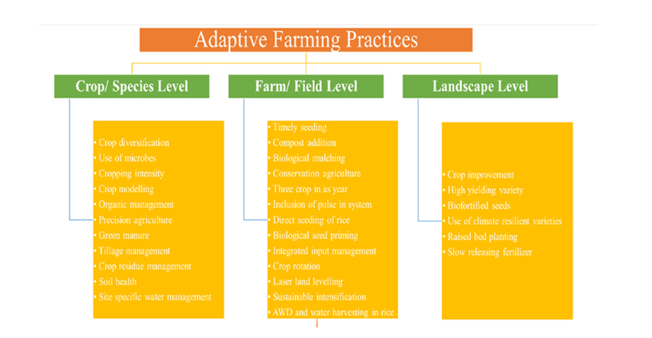
- Nature based solutions : Promote practices that mimic natural processes, such as sustainable agriculture and wetland restoration. Eg Carbon Farming
- Ecosystem-Based Adaptation : Indonesia has initiated projects to restore degraded mangrove forests, which protect coastal areas from storm surges and absorb carbon.
Indian Strategies for Mitigation and Adaptation
- Heat Action Plan ( Ahmedabad heat action plan )
- Restoring traditional water bodies ( Mission Kakatiya of Telangana )
- Disaster preparedness : ( Early warning system & Stronger shelters )
- Coastal Adaptation strategies : Integrated Coastal Zone Management
Way Forward :
Currently the world is heading toward ~2 to 3°C of global warming, at best, if all net-zero pledges and nationally determined contributions are implemented it could reach just below 2°C. This would lower tipping point risks somewhat but would still be dangerous as it could trigger multiple climate tipping points.
Source :
Where to use :
Paper I ( Geography Optional ) : Climatology
Paper I ( General Studies ) : Global climatic changes
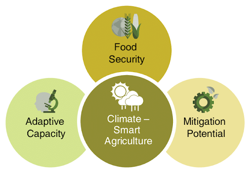
ADAPTIVE AGRICULTURE
Why in news : The recent report of Centre for Science and Environment highlights that organic and natural farming offer several advantages over chemical-dependent inorganic methods.
About :
What is Adaptive Agriculture ?
It refers to the necessity to adapt to the reality of climate change in our world, and to develop food systems to healthily feed our world. It acknowledges the need for individuals to develop and grow their own healthy personal relationships with all aspects of food production.
Why does India need Adaptive Agriculture ?
- Increased Extreme Weather Events : According to the Global Climate Risk Index by Germanwatch, India ranks among the top countries severely impacted by extreme weather events from 2000 to 2019.
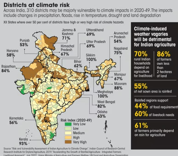
- Elevated Climate Risks : The Indian Council of Agricultural Research (ICAR) has reported that 90% of India's districts are exposed to climate risks, with 54% categorized as having "high" or "very high" risk levels.
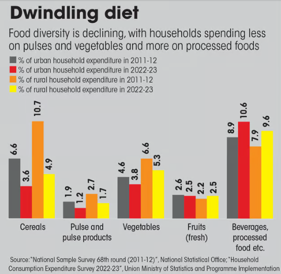
- Agricultural Vulnerability : Rainwater is crucial for 55% of India's net sown area, making it extremely vulnerable to climate change. Therefore, a significant portion of food security and the livelihood of 61% of farmers, who depend on rainfed agriculture, hinges on the timely and adequate arrival of rainfall.
- Rural Vulnerability : Nearly 70% of rural households rely on agriculture, with 86% being small and marginal farmers.

Government Initiatives
- National Initiative on Climate Resilient Agriculture : Launched in 2011 and led by the ICAR-Central Research Institute for Dryland Agriculture (CRIDA), this initiative focuses on developing climate-resilient agricultural practices.
- National Mission for Sustainable Agriculture : The National Mission for Sustainable Agriculture (NMSA), introduced in 2014-15, aims to enhance agricultural productivity, sustainability, and climate resilience.
- Paramparagat Krishi Vikas Yojana : Promotes organic farming practices.
- Mission Organic Value Chain Development for North East Region: This initiative targets the northeastern states of India, aiming to establish a complete organic value chain encompassing production, processing, marketing, and consumption.
- National Mission on Natural Farming : This mission seeks to advance natural farming practices nationwide, encouraging methods that improve soil health, reduce reliance on chemical inputs, and enhance agricultural sustainability.
- National Cooperative Organics Limited : In 2023, the Union Ministry of Cooperation established the National Cooperative Organics Limited (NCOL) to boost the marketing of organic produce through cooperatives, introducing the "Bharat Organics" brand to facilitate better sales.
- Bio-input Resource Centres : Under the National Mission on Natural Farming (NMNF), bio-input resource centres are being set up to bridge knowledge gaps, improve the availability of inputs, and support the preparation of organic and bio-inputs.
- Promoting FPOs : The Union and state governments are actively encouraging the formation of Farmer Producer Organisations (FPOs).
Source :
Where to use :
Paper II ( Geography Optional) : Agriculture
Paper III ( General Studies ) : Cropping Pattern
12 NEW INDUSTRIAL SMART CITIES
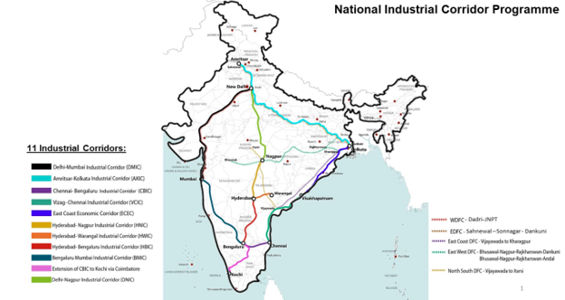
Why in news : Recently, the Union Cabinet, under the leadership of Prime Minister has approved the establishment of 12 industrial smart cities across 6 major industrial corridors in 10 states under the National Industrial Corridor Development Programme.
About :
What is an Industrial Smart City ?
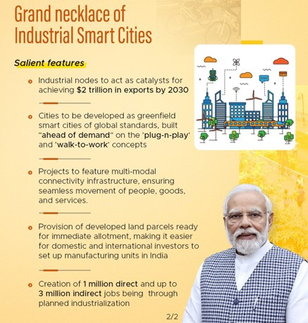
An industrial smart city is a modern urban zone that leverages advanced technologies and data analytics to optimize industrial operations while promoting sustainable development. These cities are designed to attract foreign investment, strengthen domestic manufacturing, and stimulate job creation.
Significance of Industrial Smart Cities
- Spatial Planning and Growth Poles: The industrial smart cities are located along major industrial corridors such as the Delhi-Mumbai Industrial Corridor (DMIC), Bengaluru-Chennai Industrial Corridor (BCIC), and others. These corridors act as growth poles, a concept by French economist François Perroux, where the development of key industrial areas stimulates growth in surrounding regions. By placing smart cities along industrial corridors, the government aims to leverage regional development, pushing economic activities from urban cores to peripheral areas, fostering balanced spatial development.
- Agglomeration Economies: The clustering of industries within these smart cities will generate agglomeration economies. This encourages higher productivity and competitiveness. Examples from existing industrial clusters such as Chennai's auto industry or the Ludhiana hosiery industry showcase the benefits of agglomeration in fostering innovation and job creation.
- Urbanization and Infrastructure: The establishment of smart cities ties into the urbanization trends in India, where urban population growth is driven by migration to regions with better infrastructure and job prospects. Smart cities are designed to provide sustainable urban living with advanced infrastructure such as integrated transport networks, green energy solutions, and digital connectivity, essential for managing urban sprawl and reducing ecological footprints.
- Industrial Location Theories: According to Alfred Weber’s theory of industrial location, industries tend to cluster around areas with lower transportation costs and access to resources and markets. The industrial smart cities are strategically located along corridors to maximize their connectivity to major transport routes, ports, and raw materials, which aligns with this theory. For example, the Delhi-Mumbai Industrial Corridor benefits from its proximity to major ports on the western coast, reducing export-import costs and promoting global competitiveness.
Case Study of Industrial Smart Cities : Dholera Special Investment Region (SIR), Gujarat
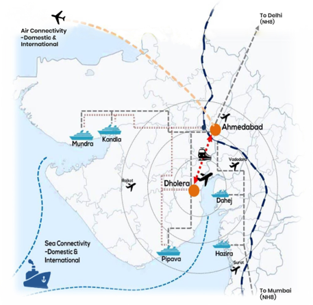
Dholera, located along the DMIC, is an example of an industrial smart city with state-of-the-art infrastructure. It is designed to host industries ranging from electronics to heavy engineering and provides plug-and-play facilities, ensuring ease of doing business. With green infrastructure, such as renewable energy integration, it aims to be a model for sustainable industrialization.
Challenges and Opportunities
- Ecological Balance and Sustainability: The industrial smart cities must balance growth with environmental sustainability. Urban ecology needs to be a focal point, with smart cities integrating green technologies such as solar energy, smart water management systems, and sustainable waste disposal. Dholera’s plan to harness solar power for industrial energy needs sets a precedent for other smart cities.
- Regional Disparities: While these cities are expected to promote regional growth, there is a risk of exacerbating regional disparities if resources and infrastructure are not equitably distributed. States such as Bihar and Odisha, which are not part of the initial corridors, could lag in development if similar industrial and infrastructural opportunities are not extended.
- Human Capital and Migration: Industrial smart cities will attract a large influx of skilled and semi-skilled workers, leading to migration from rural areas. This may lead to rural depopulation and increased pressure on urban resources. However, this also presents an opportunity to improve human capital development through skill training and education programs tailored to the industries within these smart cities.
Source :
Where to use :
Paper II ( Geography Optional ) : Industries , Regional Development
Paper III ( General Studies ) : Infrastructure, Economic growth
Solar Atmosphere
Solar Atmosphere: It refers to the outer layers of the Sun that are visible or near-visible from Earth. These layers extend above the Sun's surface, or photosphere, and consist of multiple regions, each with distinct properties and characteristics. The main layers of the solar atmosphere are Photosphere , Chromosphere and Corona.
White Gold
White Gold : Lithium (Li), sometimes also referred as ‘White gold’ due to its high demand for rechargeable batteries, is a soft and silvery-white metal. It is an important component of electrochemical cells used in batteries of EVs, Laptops, Mobiles etc. It is also used in thermonuclear reactions.
Hygroscopy
Hygroscopy : A substance that has the ability to adsorb and absorb moisture or water from the surrounding environment is known as hygroscopic and its property is called hygroscopy.Examples - Silica gel, honey, methanol, concentrated sulphuric acid, glycerine, ethanol, etc. are hygroscopic substances that absorb moisture.
HighSeas
High Seas : The high seas are defined by international law as all parts of the ocean that aren't included in the exclusive economic zone, the territorial sea, or the internal waters of a country, or in the archipelagic waters of an archipelagic country.
Oil zapping
Oil zapping : It is a bio-remediation technique involving the use of 'oil zapping' bacteria. Oilzapper feeds on hydrocarbon compounds present in crude oil and the hazardous hydrocarbon waste generated by oil refineries. It converts oil sludges into harmless CO2 and water.
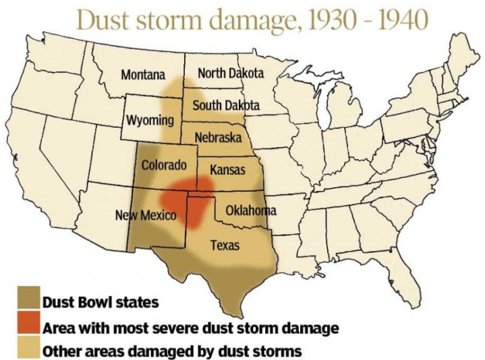
DUST BOWL IN USA IN 1930s
Dust Bowl was one of the most devastating environmental disasters in the history of the United States. Over-cultivation of marginal lands without proper soil conservation measures led to the removal of natural grasslands, leaving the soil vulnerable. Approximately 850 million tons of topsoil were blown away in just the year 1935, leaving large tracts of land infertile. Over 100 million acres of farmland (roughly the size of Texas) were rendered unsuitable for agriculture.
Source :
Where to use ?
Paper II ( Geography Optional ) : Environmental Disaster
Places in News - 10 September 2024
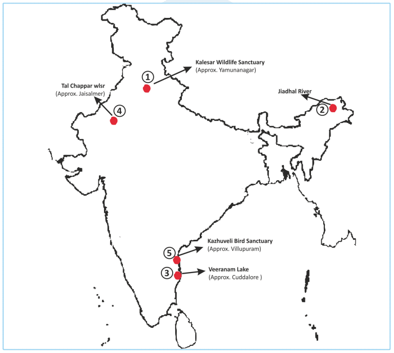
1. Kalesar Wildlife Sanctuary
Why in news : Recently, the Supreme Court stayed the construction of four proposed dams inside Kalesar Wildlife Sanctuary in Haryana’s Yamunanagar district as the construction will not only negatively impact the wildlife and local community but also harm the ecosystem.
- It is situated in the foot hills of Shiwalik ranges of mighty Himalayas.
- It falls under Yamunanagar District of Haryana, sharing boundary with three States viz., Himachal Pradesh, Uttranchal & U.P.
- The Yamuna river form the Eastern boundary with Uttar Pradesh, the main Shiwalik ridge separates State boundary among Haryana, Himachal Pradesh & Uttaranchal in the north.
- The park was declared as National Park on 8th December 2003 having an area of 11570 acres.
- Approx : Yamunanagar
2. Jiadhal River
Why in news : Heavy precipitation in Assam is actively reshaping the path of the Jiadhal River, leading to soil erosion and posing a significant threat to agriculture.
- It originates in the sub-Himalayan mountains of Arunachal Pradesh at an altitude of 1247m.
- After passing through a narrow gorge in Arunachal Pradesh, the river enters the plains of Assam in Dhemaji district, where it flows in braided channels.
- The river finally debouches into the Brahmaputra near Selamukh in Lakhimpur district.
3. Veeranam Lake
Why in news : According to data from the Chennai Metropolitan Water Supply and Sewerage Board (CMWSSB), Veeranam Lake, a primary water source for Chennai has dried up.
- Veeranam Lake, a vital water source for Chennai, lies in Tamil Nadu's Cuddalore district.
- It was regarded as one of the longest man-made lakes in the world with a length of 14 km.
- The source of Veeranam is the river of Kollidam, which is the Northern distributary of the Cauvery River, where the Vadavaru River links both the Veeranam and Kollidam.
- Approx : Cuddalore
4. Tal Chappar wls
Why in news : MoEF proposes to designate Tal Chhapar Sanctuary as Eco-Sensitive Zone
- The Tal Chhapar Sanctuary is situated on the border of the Great Indian Thar Desert.
- Tal Chhapar is a distinctive shelter of the most graceful Antelope seen in India, “the Blackbuck”.
- This Sanctuary has nearly flat territory and combined thin low-lying region. It has got open and wide grasslands with spread Acacia and Prosopis plants that offer it a look of a characteristic Savanna.
- Approx : Jaisalmer
5. Kazhuveli Bird Sanctuary :
Why in news : Kazhuveli Bird Sanctuary have been designated as Ramsar site of International importance .
- It is a protected area and bird sanctuary located in Villupuram district of Tamil Nadu.
- After Pulicat lake, Kazhuveli, at 5,151.6 hectares, attracts many long-distance migrant birds from Central Asia and Siberia and is believed to be the second-largest brackish lake in southern India.
- Kazhuveli wetland is one of the 94 identified wetlands under the National Wetland Conservation and Management Programme launched by the Union government. The state has three other wetlands Point Calimere, Pallikaranai marsh, and Ousteri lake, under the same programme.
- Approx : Villupuram
Fortnightly KOSMOS MCQsPractice
Q1. Consider the following statements:
- The Tawa Reservoir is situated within the Satpura Tiger Reserve and is adjacent to the Satpura National Park and Bori Wildlife Sanctuary.
- The Tawa River, the longest tributary of the Narmada River, has its source in the Mahadeo Hills located in the Chhindwara district.
Which of the statements given above is/are correct?
- 1 Only
- 2 Only
- Both 1 and 2
- Neither 1 nor 2
Q2. Consider the following statements regarding the Mahananda River:
- It originates in the Darjeeling hills of West Bengal and flows through Assam, Bihar, and Bangladesh.
- It is a distributary of the Ganga River.
- The Ganges river dolphin is found in the Mahananda River.
How many of the above is/are correct?
- Only one
- Only two
- All three
- None
Q3. Consider the following statements regarding the Gross Environment Product (GEP):
- GEP is an element of Green GDP that assesses the value of ecosystem services for human well-being and sustainable development.
- The GEP Index accounts for both natural processes and human-led conservation initiatives, such as Amrit Sarovars.
Which of the statements given above is/are not correct?
- 1 Only
- 2 Only
- Both 1 and 2
- Neither 1 nor 2
Q4. Consider the following statements about Volcanoes:
- Shield volcanoes are among the most explosive, often collapsing inward during eruptions instead of growing taller.
- Calderas are the largest and most gently sloping volcanoes on Earth, mainly formed from basaltic lava.
- Magma refers to the molten rock and associated materials found beneath the Earth's surface.
Which of the above statements is/are correct?
- 3 only
- 1 and 2 only
- 2 only
- 1, 2 and 3
Q5. Gumti Wildlife Sanctuary, Rowa Wildlife Sanctuary and Clouded Leopard National Park are located in?
- Assam
- Arunachal Pradesh
- Tripura
- Meghalaya
Q6. Callisto, Europa, and Ganymede are moons of which of the following planets?
- Mars
- Saturn
- Jupiter
- Neptune
Q7. Consider the following characteristics:
- These highly intelligent, long-haired primates are native to the islands of Borneo and Sumatra.
- Their primary mode of communication is through facial expressions.
- They are listed as Critically Endangered on the IUCN Red List.
Which of the following species best matches the above description?
- Eastern Gorilla
- Orangutan
- Javan Slow Loris
- Western Lowland Gorilla
Q8. Consider the following statements related to Horseshoe Crabs:
- They are the last remaining members of the order Xiphosura.
- Tachypleus gigas is found in Odisha and West Bengal, while Carcinoscorpius rotundicauda is found in Andhra Pradesh.
- Their blood is a vivid blue and contains immune cells that are extremely sensitive to toxic bacteria.
How many of the above statements is/are correct?
- Only one
- Only two
- All three
- None
Q9. Consider the following statements related to natural rubber:
- It is cultivated in loamy or laterite soils.
- India ranks as the second largest producer of natural rubber globally.
- Kerala leads as the largest rubber-producing state in India.
How many of the above statements is/are correct?
- Only one
- Only two
- All three
- None
Q10. Consider the following:
- Antimony and copper
- Erbium and Rhodium
- Potash and Barite
Which of the above mentioned pairs are considered as Critical minerals in India ?
- One pair
- Two pairs
- Three pairs
- None
Share the article
Edukemy’s Current Affairs Quiz is published with multiple choice questions for UPSC exams
MCQ
Get Latest Updates on Offers, Event dates, and free Mentorship sessions.

Get in touch with our Expert Academic Counsellors 👋
FAQs
Geography Current Affairs focuses on the contemporary issues, events, and developments in the field of geography. It covers recent geographical phenomena, environmental changes, geopolitical shifts, and related news. This differs from regular geography studies which may focus more on foundational concepts, historical contexts, and theoretical frameworks.
Updates are provided regularly to ensure that subscribers stay informed about the latest developments in geography. Typically, updates are provided on a fortnightly basis, depending on the frequency of significant events and changes in the field.
Absolutely. Geography Current Affairs serves as a valuable resource not only for Geography optional but also for GS papers, especially GS Paper 1 (covering Indian Heritage and Culture, History, and Geography of the World and Society) and GS Paper 3 (covering Technology, Economic Development, Biodiversity, Environment, Security, and Disaster Management). It aids in building a holistic understanding of various topics and strengthens answer-writing skills by incorporating contemporary examples and perspectives.
Geography Current Affairs holds immense importance for UPSC preparation, particularly for aspirants opting for Geography optional. It helps candidates stay updated with the latest developments, geographical phenomena, environmental issues, and geopolitical shifts worldwide, aligning them with the dynamic nature of the subject as tested in the UPSC examinations.

